Showing 19137 items matching "left"
-
 City of Moorabbin Historical Society (Operating the Box Cottage Museum)
Photographs, 7 x B&W Circa 1918 Cheltenham Methodist Youth Group, Circa 1918 Photos of Cheltenham Methodist Youth Group, 1918
Circa 1918: Various Photos of the Cheltenham Methodist Youth Group. Row 1 and 2: "At Flinders". Row 3: 1st Left, "Holidaying at Cockatoo". in 1852 Stephen Charman, who had arrived in Melbourne 1842 aged 21 years as one of Henry Dendy's emigrants, purchased 160 acres in Spring Grove ( now Cheltenham). Stephen and his family lived in a wattle and daub hut and worked hard to establish a market garden, poultry and pig farm. The first Methodist Church Services were held at their home. In 1855 Stephen gave 1 acre of his land on Balcombe Road to the Methodist Church for a School, Burial ground and a Chapel which was built in 1857.The Methodist Church, Balcombe Road was the 2nd religious building to be erected in Spring Grove now known as Cheltenham c 18577 small black and white photographs of the Cheltenham Methodist Youth Group at Flinders, Cockatoo and unkown locations, c 1918 . First 3 photos are of male cyclists on a trip to Flinders, Victoria. Photo 4 shows 6 ladies and a man on holiday at Cockatoo in the Dandenong Ranges ,Victoria . Photos 5 to 7 show men, women and children in bushland surroundings of unrecorded locations.Photo 1 - 3 on back : Flinders 1918 Photo 4 left on back : Holiday at Cockatoo right on back : Whitehead Photo 5-7 nilcheltenham, cheltenham methodist youth group, 1914, 1918, charman stephen, gettens mary, spring grove, methodist church, charman road, balcombe road, dendy henry, henry dendy's special survey 1841, youth groups, social groups, market gardners, early settlers, pioneers, dairy farmers, poultry farmers, pig farmers,moorabbin, brighton, -
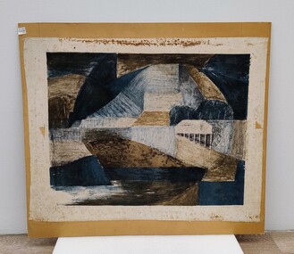 Royal Australian and New Zealand College of Obstetricians & Gynaecologists (RANZCOG)
Painting, John 'Jack' Courier, Blue Landscape
It is likely this item was received from the estate of John 'Jack' Courier. Courier left a bequest to the College consisting of a significant number of artworks by himself and others.Abstract artwork on paper. Artwork consists of a range of geometric shapes in shades of blue, brown and black. The artwork has been adhered to a piece of brown board. Title of work written at bottom left is partly obscured, but appears to read 'Blue Landscape'. The artist's name is handwritten at bottom right and reads 'J. Courier 5/12'. The board appears to have been previously housed inside a frame, as the back edges of the board have suffered losses from the removal of tape. Handwritten inscription on the back of the work has been partially lost, but reads '...E LANDSCAPE/J. COURIER/368 TOORAK RD/STH YARRA/Price $22'. There are four small stickers from Gibson's Auctioneers attached to the back of the artwork. -
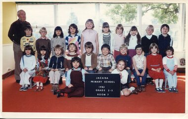 Broadmeadows Historical Society & Museum
Photograph - School Photograph, Jacana Primary School: Grade 2-3, Room 7, 1982, 1982
This 1982 photograph of Grade 2–3, Room 7 at Jacana Primary School offers a vivid snapshot of suburban school life in Melbourne during a period of significant social and urban transformation. Established in 1959, Jacana Primary served as a central educational and community hub until its closure in the early 2000s. More than just a place of learning, the school was a space where generations of students and teachers developed a strong sense of identity, connection, and shared experience. The image reflects the school’s commitment to fostering an inclusive and supportive environment for all learners. It also subtly captures the growing cultural diversity of Jacana in the late 20th century, as suburban development brought together families from a wide range of backgrounds. As part of the school’s visual archive, this photograph contributes to a broader understanding of how public education shaped community identity, promoted social cohesion, and left a lasting legacy in the lives of children and families.This 1982 classroom photograph of Grade 2–3, Room 7 at Jacana Primary School is of historical and cultural significance as a representation of suburban public education in Melbourne during a time of considerable social and demographic change. Taken during a period when Jacana and its surrounding suburbs were experiencing rapid development and increasing cultural diversity, the image reflects the evolving identity of the local community. Jacana Primary, established in 1959 and operating until the early 2000s, played a vital role as both an educational institution and a community anchor. This photograph captures more than a moment in a school year—it documents the lived experiences of students and teachers who contributed to the school’s inclusive and supportive environment. As part of the school’s visual archive, the image provides valuable insight into the role of public education in shaping community identity, fostering social cohesion, and creating lasting intergenerational connections. It stands as a testament to the everyday lives and shared histories of families in Melbourne’s northern suburbs.Colour Photograph mounted on white card, and laminatedBack: Top Left Corner in pencil: J.P.S Top right Corner: (Blue Label): PH-2129 Manufacturers mark; Sakurcolorjacana primary school, education, photograph, group photograph, 1982 -
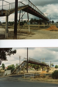 Stawell Historical Society Inc
Photograph, Railway Step Bridge Stawell 1991 -- 4 Photos 2 on one page & 2 Individual Photos
Series of four photos of Railway Step Bridge Stawell 1991Four (4) Colour Photographs, two on one page and 2 individual Photographs.The Two photographs one showing a footbridge in the distance with two cement pipes in front, and a pile of soil further back. A Truck is parked under the bridge. Buildings are in the distance on the lsft side. The Lower photograph is showing the bridge almost dismantled with the surfces of the bridge being held by two cranes with a person on the brdge. The other two photgraphs show the bridge from the groundlooking across the railway tracks one is a clsoe up of the bridge. On the rear of the tow Individual Photographs 224-2a on the top from the left Stawell Old Railway Bridge Bottom left corner ST1-2 224-2b From top left Stawell Old Railway bridge 1991. Bottom left ST1-4stawell, railways -
 Glenelg Shire Council Cultural Collection
Drawing - Drawing, botanical, Collin Elwyn Woolcock, Olearia speciosa (Netted Daisy-bush), 1984
Part of "Woolcock Gallery Collection". Exhibited CEMA 1989.Drawings of a cutting and flower and leaf details of plant with pale orange and green stems, large green crinkle-edged foliage and white daisy-like flowes with orange centres. Six drawings include one branch with foliage and flowers, one flower head detail in orange, white and green (side view), one flower detail (above) one stamen detail (orange and grey) (sideview) and two leaf details, one front (green) and one back (grey). The work is on white paper mounted in a double matt (off-white on pale apricot), framed under glass in a gold and grey-green frame.Front: CEW/84 (lower left in image, next to stem) (maroon pencil) Olearia speciosa (Netted Daisy-bush) (lower left) (pencil) Back: 17 (upper left) (pen)collin woolcock, botanical, woolcock collection, cema -
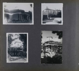 Glen Eira Historical Society
Album - Album page, Craigellachie, 273 Orrong Road, Circa 1972
This photograph is part of the Caulfield Historical Album 1972. This album was created in approximately 1972 as part of a project by the Caulfield Historical Society to assist in identifying buildings worthy of preservation. The album is related to a Survey the Caulfield Historical Society developed in collaboration with the National Trust of Australia (Victoria) and Caulfield City Council to identify historic buildings within the City of Caulfield that warranted the protection of a National Trust Classification. Principal photographer thought to be Trevor Hart, member of Caulfield Historical Society. Most photographs were taken between 1966-1972 with a small number of photographs being older and from unknown sources. All photographs are black and white except where stated, with 386 photographs over 198 pages. From Victorian Heritage Database citation for HO40 Craigellachie 2b & 2c Lynedoch Avenue Caulfield North https://vhd.heritagecouncil.vic.gov.au/places/35209 as at (28/10/2020) Craigellachie" is situated at No. 2B Lynedoch Avenue, Caulfield North, and was built for the noted investor, pastoralist and politician, William Pearson, not earlier than 1864 and possible in 1876, undergoing several substantial and contributory extensions during the nineteenth century. It is historically and aesthetically significant. From Victorian Heritage Database citation for HO40 Craigellachie https://vhd.heritagecouncil.vic.gov.au/places/35209 as at (28/10/2020) It is historically significant (Criterion A) as the Melbourne home of William Pearson, MLA, MLC and principal shareholder in Walhalla's Long Tunnel Extended Gold Mining Co. which sustained the township well past the turn of the twentieth century and occupied fifth place amongst Victoria's richest mines. It is aesthetically significant (Criterion E) for its capacity to demonstrate Pearson's continuing financial success throughout the mid to late nineteenth century, the additions associated with the tower being most noteworthy as an example of the lasting appeal of the Italian Style, popularized in the pattern books of the day. The Ailanthus altissima (Tree of Heaven) is significant as an outstanding example of a species that is rare in cultivation, as well as for its very high aesthetic value. The Araucaria bidwilli is notable as a fine example of a species infrequently planted in Melbourne and rarely found in private suburban gardens.Page 157 - four photographs of Craigellachie - exterior views. Handwritten: CRAIGELLACHIE [top left] / Neg 212 1973 [under bottom right photo] / 157 [bottom left]trevor hart, verandah, orrong road, tower, cast iron lacework, curved windows, decorative brackets, italianate, mansion, 1870's, william pearson, inkerman street, apartments, spire, decorative plaster work, rendered walls, arched windows, moulded ornaments, 1860's, lynedoch avenue, classical style, caulfield north, craigellachie, st kilda east, late victorian style, garages (private), gardens, cast iron work, ailanthus altissima, araucaria bidwilli, trees -
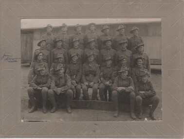 Rutherglen Historical Society
Image, c1915
Black and white photograph, mounted on cardboard, of 25 young men in military uniform.Written on mount to the left of the photo: "Jim Downs" with a mark on photo pointing to man on far left, second row.soldiers, world war i, world war 1, ww1, wwi -
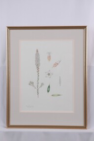 Glenelg Shire Council Cultural Collection
Drawing - Drawing, botanical, Collin Elwyn Woolcock, Epacris lanuginosa (Woolly-style Heath), 1970-1990
Part of Woolcock Gallery Collection Exhibition, CEMA, 1989.Drawings of a cutting and flower heads of a plant with brown stem, green long and narrow foliage and star-shaped flowers in clusters. Seven drawings, including one branch with flowers and foliage, two white and brown flower heads (side view), one star-shaped flower head (above view), one detail of flower stamen and two leaf details. The work is mounted in a double matt (pale grey on apricot) and framed under glass in a gold and grey-green frame.Front: Epacris lanuginosa Woolly-style Heath (lower left) (pencil) Back: 7 (upper left) (pen)collin woolcock, botanical, cema, woolcock collection, botanical drawings, illustrations -
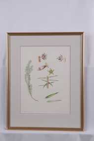 Glenelg Shire Council Cultural Collection
Drawing - Drawing, botanical, Collin Elwyn Woolcock, Acrotriche serrulata (Honeypots), 1989
Part of "Woolcock Gallery Collection" Exhibition 1989, CEMAFramed drawing of cutting, flower and leaf details of plant with brown stem, long pointed green leaves and green and purple flowers. Eight drawings, including one cutting, four flower details (3 side views, 1 above view) and 3 leaf details. The work is mounted on pale purple (first layer) and pale Grey (second layer) matt. It is framed under glass in a gold and grey-green frame.Front: CEW (born pencil - next to stem). Acrotriche serrulata (bottom left) Back: 8 (upper left)botanical, woolcock, woolcock collection, collin woolcock, botanical drawings -
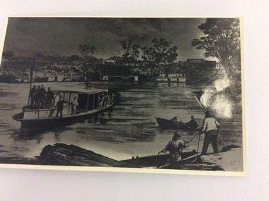 Port of Echuca
Black and white photograph of an engraving, Approximately 1970
This is a photograph of an engraving showing the first train arriving at the Echuca Wharf on 25/09/1865. The photograph appeared in the Illustrated Australian News on 25/09/1865. It also appeared in Susan Preiestly's book, 'Echuca; A centenary history' in 1965 on page 46.. The picture is of interest because it shows the size of the wharf in 1865. It also shows all the crowds to welcome the first train. It also shows the buildings along Murray Esplanade. In the far left the Steam Packet Hotel, Shackell's Bond Store and the St George's Hall, next the The Bridge Hotel. Five large steam ships are visible, all carrying crowds of people. In the foreground is the S.S Melbourne. Two rowing boats are in the left foreground.This engraving is significant because it shows the welcoming of the first train onto the wharf. The photograph shows the size of the wharf in 1865, as well as the street scape and the vessels on the water at the wharf. There is also some activity at Evan's sawmill. There are crowds on the wharf, and lining Murray Esplanade. It also shows that most of the crowd are males, which helped describe the role that women played in public life in the 1880's. A black and white photograph of an engraving of a busy Echuca wharf scene in 1865. The first train is arriving at the wharf. There are crowds of people, and in the foreground is the S.S. Melbourne. On the front of the photograph in the bottom right hand corner are the letters R.G. (Is this the Artist's initials?) On the back of the photo, written in pencil are the words "Day first train came through to the wharf. Of interest because of buildings far left. Steam Packet 1865. From Ilustrated Australian News. 25th September 1865."echuca wharf, susan preistley, railways, state library of south australia., illustrated australian news., s.s.melbourne, steam packet hotel, shackell's bond store, st george's hall, bridge hotel -
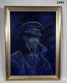 Bendigo Military Museum
Painting - PORTRAIT, FRAMED, Post WW2
Gold coloured wooden frame, blue oil paint portrait of soldier C PERRY, in hat.Handwritten bottom left: “C PERRY”illustrations-oil, military history, portrait -
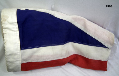 Bendigo Military Museum
Flag - FLAG, UNION JACK, 1965
Flag, colours red white and blue British Union Jack“OGOF” stamped in ink on left sideflags - national - british, military history, passchendaele trust collection -
Glenelg Shire Council Cultural Collection
Photograph, Crucifix, n.d
Con Kroker Private CollectionBlack & white photo of part of bluestone external wall of All Saints Catholic Church, Portland, with a large wooden cross and statue of Christ, attached to it.Back: Kroker, top left, pencilcon kroker, kroker, photography, all saints church, portland, crucifix -
Glenelg Shire Council Cultural Collection
Photograph - Photograph - Machinery, n.d
Port of Portland Authority ArchivesBack: (1) - ink top leftport of portland archives -
 City of Moorabbin Historical Society (Operating the Box Cottage Museum)
Document, laminated photocopy of 'Plan of Moorabbin 1850', 1853
Weston Bate, 'A history of Brighton' 1962 informs us that in 1840 Henry Dendy, who was a farmer in Sussex England, paid 5,120 pounds sterling @ 1pound per acre for a 'Special Survey of Land in Port Phillip , Australia. Henry arrived in Australia in 1841 on the frigate 'York' with his wife, son, and three servants. He also took advantage of the Government Assistance of Free Immigrants for Survey Purchasers, to help on his estate and persuaded some Sussex men with their families to follow him. However when Dendy arrived in Port Phillip he found that LaTrobe and Gipps were trying to raise the price of land close to Town to 15pounds per acre. Dendy asked merchant J.B.Were to manage his affairs and they went ahead with plans to subdivide the surveyed land called 'The Brighton Estate' This area of land extended easterly from the Port Phillip Bay to East Boundary Road and from North Road to South Road in the Parish of Bourke Victoria. The Privy Council, England , decide that Henry Dendy could purchase the land at 1pound per acre. Land Sales proceeded from 1844 as more immigrants established market gardens, farms and varied businesses in 'Moorabbin'This is a photocopy of a Map of the Moorabbin , County of Bourke c1850 showing the 'Henry Dendy Special Survey 1841'A photocopy of a Map of the Moorabbin , County of Bourke c1850. A3 size laminatedLeft corner : MOORABBIN / COUNTY OF / BOURKEdendy henry, dendy special survey 1841, brighton, moorabbin, ormond, bentleigh, market gardeners, pioneers early settlers, box william, box elizabeth -
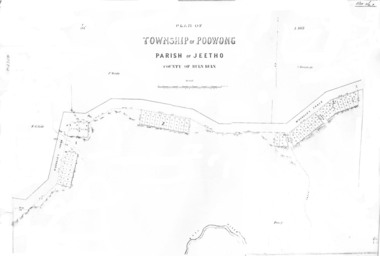 Poowong Historical Group
Poowong Township Map 1
Photocopy of original map - fair quality41584 pencilled on top left corner -
 Glen Eira Historical Society
Album - Album page, St Stephen's Presbyterian Church, Balaclava Road, Circa 1972
This photograph is part of the Caulfield Historical Album 1972. This album was created in approximately 1972 as part of a project by the Caulfield Historical Society to assist in identifying buildings worthy of preservation. The album is related to a Survey the Caulfield Historical Society developed in collaboration with the National Trust of Australia (Victoria) and Caulfield City Council to identify historic buildings within the City of Caulfield that warranted the protection of a National Trust Classification. Principal photographer thought to be Trevor Hart, member of Caulfield Historical Society. Most photographs were taken between 1966-1972 with a small number of photographs being older and from unknown sources. All photographs are black and white except where stated, with 386 photographs over 198 pages. From: Glen Eira Heritage Management Plan (1996) by Andrew Ward and Associates In 1905, the land was vacant in Balaclava Road, north side, from Kooyong Road east to the right of way, except for one house. A block of this land was acquired by the Presbyterian community and a timber church erected there in 1910. In time, a larger church was required. After several years of fund raising led by George Kinross, a new red brick St Stephen's church was built in 1926 to the design of architects Haddon and Henderson. George Currie was the builder and the cost of construction was £5,100.From: Glen Eira Heritage Management Plan (1996) by Andrew Ward and Associates: St Stephens has architectural importance as a noteworthy example of a Gothic Transitional design in the Arts and Crafts eclectic manner (see Stylistic Typology in National Trust's Historic Church's Study}. The facade treatment successfully combines Christian symbols with Gothic forms in the Arts and Crafts mode (comparable with Haddon's Presbyterian Church, Malvern (1906) and Haddon and Henderson's Oakleigh Church (1928). It is locally important as an example of Robert Haddon's work in Caulfield, where he also lived (4 Glenferrie St q.v.).Page 25 of Photograph Album - four black and white photographs of St Stephen's Presbyterian Church, with two photographs in landscape mode across the top showing information about who designed the building in one and showing the church name and year founded in the other; and two in portrait mode in the bottom section showing 2 different heavy wooden doors.Hand written: 25 [bottom left]trevor hart, caulfield north, balaclava road, george kinross, haddon and henderson, george currie, st stephen's, 1900's, 1920's, gothic transitional, christian symbols, arts and crafts, robert haddon, stylistic typology, gothic, presbyterian church, architects, red brick, doors, memorials -
 Glen Eira Historical Society
Album - Album page, Halstead, Bambra Road, Circa 1972
This photograph is part of the Caulfield Historical Album 1972. This album was created in approximately 1972 as part of a project by the Caulfield Historical Society to assist in identifying buildings worthy of preservation. The album is related to a Survey the Caulfield Historical Society developed in collaboration with the National Trust of Australia (Victoria) and Caulfield City Council to identify historic buildings within the City of Caulfield that warranted the protection of a National Trust Classification. Principal photographer thought to be Trevor Hart, member of Caulfield Historical Society. Most photographs were taken between 1966-1972 with a small number of photographs being older and from unknown sources. All photographs are black and white except where stated, with 386 photographs over 198 pages.From the Victorian Heritage Register Database - Citation for Halstead, 23 Bambra Road as at (as at 12/10/2020) https://vhd.heritagecouncil.vic.gov.au/places/276: Halstead is believed to be the oldest standing residence in Caulfield constructed in 1857 with subsequent additions during the 19th Century. The house was built for and owned by James Dickson, a stock agent, until his death in 1880. Although on a much reduced parcel of land, Halstead is one of the few remaining remnants of Caulfield when it was an area of mansion houses occupied by town residing squatters, professional and business men. It is important for its place in the socio-economic history of south eastern suburban Melbourne, the inland pattern of development stretching from Malvern through Murrumbeena. Architecturally the single storey building displays a history of alteration and addition. Its main front presents with a single storey cast iron verandah across the full width, including the two pavilion wings at each end. Located towards the rear on the Halstead Street side is the substantial three storey tower with its Mansard roof and cast-iron balustrade which makes the house clearly visible from Halstead Street and Bambra Road. Because of internal alteration the importance of the building relates to the exterior only of the main house. Halstead is believed to be the oldest standing residence in the city of Caulfield. https://vhd.heritagecouncil.vic.gov.au/places/43645: "Halstead" is regionally important as a surviving large villa from the early Victorian (1850's) period, offering insights into the lifestyles of the privileged in Caulfield at that time. The later tower is of architectural interest for its use of Medieval Romanesque enrichment.Page 33 of Photograph Album with one landscape photograph of the exterior of Halstead, taken from the street.Hand written: 33 [bottom left] trevor hart, caulfield north, bambra road, 1850's, halstead, james dickson, mansion, villa residence, cast iron verandah, pavillion wings, halstead street, victorian, tower, balustrading, decorative brackets, mansard roof, brick, slate roof, curved windows, single storey mansions, cast iron work, medieval romanesque style, slate roofs, gardens -
 Glen Eira Historical Society
Album - Album page, Glenferrie Street, 4, Circa 1972
This photograph is part of the Caulfield Historical Album 1972. This album was created in approximately 1972 as part of a project by the Caulfield Historical Society to assist in identifying buildings worthy of preservation. The album is related to a Survey the Caulfield Historical Society developed in collaboration with the National Trust of Australia (Victoria) and Caulfield City Council to identify historic buildings within the City of Caulfield that warranted the protection of a National Trust Classification. Principal photographer thought to be Trevor Hart, member of Caulfield Historical Society. Most photographs were taken between 1966-1972 with a small number of photographs being older and from unknown sources. All photographs are black and white except where stated, with 386 photographs over 198 pages. From Glen Eira Heritage Management Plan 1996 by Andrew Ward: In 1905, most of portion 27 was vacant land, however Glenferrie Street had been formed and the land subsequently subdivided. In 1906, Robert Joseph Haddon, architect and painter, designed and built for his private residence, a brick house on the west side. Haddon named the house "Anselm". Also built on the property were a garage and fibro cement studio. "Anselm" is architecturally important at the State level as a substantially intact, highly personalised and boldly expressed house expressive the Arts and Crafts movement and incorporating Art Nouveaux enrichment in a variety of forms, the use of ornamental terra cotta tiles to the comer tower being of special note. Its importance at the State level is strengthened by its place as the home of the noted architect and Melboume's most influential exponent (Freeland, J.M., Architecture in Australia, p. 213) of the Art Nouveaux movement. Victorian Heritage Register https://vhd.heritagecouncil.vic.gov.au/places/4442 What is significant? Anselm was designed by noted English born architect Robert Joseph Haddon(1866-1929) as his own house and constructed in 1906. A single storey Arts and Crafts influenced red brick house with attic, Anselm has a pyramidal slate roof with prominent chimney stacks. There is a octagonal corner tower with saucer shaped domed roof surmounted by a weather vane, and the tower has decorative terracotta panels immediately below the eaves line. The front door opens immediately into a large living or common room, screened from view by a timber and bottle glass screen. The large room was designed to function as a drawing and dining room. The house is rich with hand crafted details including door and window furniture, wrought iron gutter brackets, fireplaces (one with built in wood box), and fire tools. The interior decoration includes hand painted frieze of Port Phillip in the study, and a hand painted frieze of turbulent sea with sailing boats in the tiled bathroom. There is a small hand painted tile at the base of the tower which states ?This building was erected AD1906 from designs by Robt J Haddon FRIBA,Lond FRIVA Melb Architect?. He also designed an attic addition which was constructed in 1927. Anselm is substantially intact although the double casement window immediately to the south of the front door was originally circular....Page 61 of Photograph Album with one exterior photograph (portrait) of Anselm.Hand written: 61 [bottom left] trevor hart, anselm, art nouveaux, arts and crafts, tower, bay window, glenferrie street, robert joseph haddon, 1900's, terra cotta tiles, double storey, caulfield north, corner tower, brick house, attics -
 Glen Eira Historical Society
Album - Album page, Congregational Church, Grange Road, Circa 1972
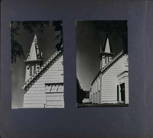
This photograph is part of the Caulfield Historical Album 1972. This album was created in approximately 1972 as part of a project by the Caulfield Historical Society to assist in identifying buildings worthy of preservation. The album is related to a Survey the Caulfield Historical Society developed in collaboration with the National Trust of Australia (Victoria) and Caulfield City Council to identify historic buildings within the City of Caulfield that warranted the protection of a National Trust Classification. Principal photographer thought to be Trevor Hart, member of Caulfield Historical Society. Most photographs were taken between 1966-1972 with a small number of photographs being older and from unknown sources. All photographs are black and white except where stated, with 386 photographs over 198 pages. This church has since become the Greek Orthodox Church. From Victorian Heritage Database: Citation for Greek Orthodox Church HO84 https://vhd.heritagecouncil.vic.gov.au/places/43587 (as at 19/10/2020) The former Primitive Methodist, later Congregational, church at 152 Grange Road, Glen Huntly, is a small timber building, erected in 1885 (89?) in South Melbourne and relocated to Glenhuntly in 1909. It is a highly individual picturesque timber structure with distinctive spire and timber enrichment. It has aesthetic, historical and social significance. Its aesthetic value is derived from the choice of materials and picturesque Gothic Revival character showing American influence. Its historical value is derived from its survival as a rare example of a Primitive Methodist Church building whilst its social value hinges on its early roles as a place of worship for the Primitive Methodists in South Melbourne and the Congregationalists in Glenhuntly.Page 73 of Photograph Album with two photographs (both portrait) of front and side views of the spire of the Congregational Church on Grange RoadHand written: 73 [bottom left] trevor hart, congregational church, grange road, gothic revival, carnegie, glen huntly, glenhuntly, greek orthodox church, primitive methodist church, spire, timber buildings -
Glenelg Shire Council Cultural Collection
Photograph - Photograph - Port of Portland with Henty Beach, n.d
Port of Portland Authority ArchievesBack: Top left -fd010 -pencilport of portland archives, henty beach -
Glenelg Shire Council Cultural Collection
Photograph - Photograph - loading frozen food onto ship, n.d
Port of Portland Authority archivesFront: (no inscriptions) Back: if(?) (pencil, left)port of portland archives, cargo, food, frozen food -
Glenelg Shire Council Cultural Collection
Photograph - Photograph - loading frozen food onto ship, n.d
Port of Portland Authority archivesFront: (no inscriptions) Back: if(?) (pencil, left)port of portland archives, cargo, food, frozen food -
Glenelg Shire Council Cultural Collection
Photograph - Photograph - loading frozen food onto ship, n.d
Port of Portland Authority archivesFront: (no inscriptions) Back: if(?) (pencil, left)port of portland archives, cargo, crane, frozen food -
Glenelg Shire Council Cultural Collection
Photograph - Photograph - Portland Harbour, n.d
Port of Portland Authority ArchivesBack: (1) - in pen, top leftport of portland archives -
Glenelg Shire Council Cultural Collection
Photograph - Photograph - Machinery, n.d
Port of Portland Authority ArchivesBack: (2) - ink, top left -
Glenelg Shire Council Cultural Collection
Photograph - Photograph - Machinery, n.d
Port of Portland Authority ArchivesBack: (2) - in ink, top leftport of portland archives -
Glenelg Shire Council Cultural Collection
Photograph - Photograph - Machinery, n.d
Port of Portland Authority ArchivesBack: (2) - ink, top left -
Glenelg Shire Council Cultural Collection
Photograph - Photograph - Machinery, n.d
Port of Portland Authority ArchivesBack: (1) - ink top leftport of portland archives -
Glenelg Shire Council Cultural Collection
Photograph - Photograph - loading frozen food onto ship, n.d
Port of Portland Authority archivesFront: (no inscriptions) Back: if(?) (pencil, left)port of portland archives, cargo, food, frozen food