Showing 1407 items matching "lockable"
-
 Phillip Island and District Historical Society Inc.
Photograph, Family Photographs and Back to Phillip Island
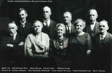
1041-01 Family of Elizabeth Rebecca Bryant & Solomon West - family identified c1924 - ?? 1926 1041-02 Back to Phillip Island c 1924. People identified in 1989 by Mrs Beth Freeman, daughter of William Otway MorrisonHistorical1041-01 Photograph: Family of Elizabeth Rebecca Bryant & Solomon West 1041-02 Photograph: Back to Phillip Island c 1924 with names1041-01: Family of Elizabeth Rebecca Bryant & Solomon West Back L-R Alfred Ernest West, Albert Bryant, Edwin Calver, William Joseph Front L-R Charles Solomon, Alice Elizabeth McDonald, Fanny Maria Morrison, Emily Elizabeth Lock, Harry Thomas 1041-02: Back to Phillip Island c.1924 Identification 1989, Mrs Beth Freeman daughter of William Otway Morrison Front L-R 1. Dan Morrison 2. Ted West 3. Norman McDonald 4. William West s/o Solomon 5. ? 6. William Otway Morrison Second Row L-R 1.? 2. Miriam West Henderson d/o John 3. ? 4. Emily West Lock d/o Solomon 5. ? 6. Fanny West Morrison w/o No. 6 above, d/o Solomon 7. Child to 10 (man with pipe) not identified Back Row L-R 1 to 5 not identified 6. Albert West, s/o Solomon 7. Marion Somerville West 8. Janet Morrison w/o Wm West (obscured) 9. Harry Brown 10. Nell West Brown d/o William West 11-13 unidentified 14. Alice West McDonald d/o Solomon 15. Jenny?west, back to phillip island c1924, morrison family, bryant, solomon -
 Phillip Island and District Historical Society Inc.
Photograph Album, Kodak, Phillip Island Cemetery, c 1990
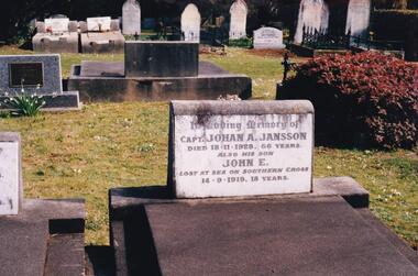
The Album was compiled by Nancy McHaffie late 1990's, with the assistance of Edith Jeffery's, with her book "Garden of Memories" and extensive knowledge of Phillip Island. The Cemetery lies back from the road and is surrounded by Manna Gums, rare Peppermint Gums, Blackwoods and other native trees. In all 25 acres of land were set aside as Crown Land in the land settlement of 1868. There are 6.2 acres of wetlands near the cemetery entrance.466-44: Captain Johan Jansson. Capatain Jansson was born in 1862 and came to Australia on the ship "Nosstaljee" in 1886. In 1887 he came to the Island and started work with Captain Lock. He bought land at Rhyll in 1891 and built a house two years later, now known as Jansson's Cottage. Johan married Evelyn Power.. a daughter of Captain Powell. He purchased the ketch "Swan" and later :Stephen" in 1914. They took chicory, seaweed, hay and other farm produce to Melbourne, returning with general cargo. Captain Jansson died in 1928 aged 66 years. 466-45: Evelyn Jansson. Evelyn was the daughter of Captain Powell. She married Johan Jansson on her 18th birthday. She died 1971 aged 95 years. Their daughter Mavis is buried with Evelyn - died 1971 aged 72 years.phillip island cemetery, johan jansson, evelyn jansson, mavis jansson, nancy mchaffie, edith jeffery -
 Flagstaff Hill Maritime Museum and Village
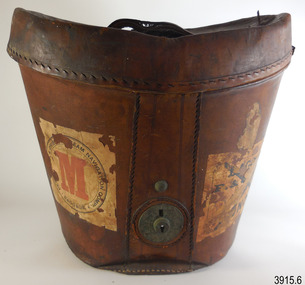
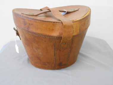
Functional object - Hat Box, John Brush, Son & Co, 1920s
This sturdy, deep hat box has been carefully constructed to give the contents utmost protection in the roughest of travel conditions. At the same time, attention to detail and quality of materials makes the box an attractive, desirable and useful piece of luggage. The supports inside the hat box show that the hat’s brim dipped at the front and back in the popular 1920s Homburg or Derby style. The hat box was likely to have been purchased, complete with its fashionable hat and personalised with the initials ‘G.M.’. The five shipping labels on the hat box tell that the owner traveller overseas with it on more than one occasion. The owner had first travelled with the shipping line Peninsular & Orient Steam Navigation Company, and may have been one the first Australian passengers in 1932, as the remnant of label on the base reads Sydney. The owner later voyaged under the company’s new name of P & O. and travelled from at least one of the voyages from Melbourne to London The square label, with “P & O” and red printed “M” in centre of circle, refers to alphabetical organisation of baggage by surname, connecting the owner ‘G.M.’ to the owner’s voyage with P & O. The P & O shipping line’s early beginnings started with the partnership of London ship broker Brodie McGhie Willcox and Scottish sailor Arthur Anderson in 1822. The partnership was joined by Irish shipowner Captain Richard Bourne in 1835 and they began operation as the Peninsular & Orient Steam Navigation Company with a service between London- Spain - Portugal. In 1932 the company expanded to include Australia with its passenger services departing from Sydney; in 1840 the company was incorporated. After various take-overs of other shipping lines and businesses, it operated under the name P & O. JOHN BRUSH The hat box was made by Australian saddle designer and maker, John Brush, Sons & Co. Brush began his saddlery trade in Roma, Queensland, His designing process included consulting with the men who rode and worked the horses. He was described in the Sydney Morning Herald of December 15, 1897, as a leading Sydney saddler, well known and reliable, with every kind of English and Australian saddle on view. John Brush established his business in 1840, operating from 371 George Street Sydney. A catalogue from that era jointly advertises John Brush (371 George Sty Sydney) and Butlers & Brush (432-4 Queen Street Sydney), both under the name of Edward Butler & Co. Pty. Ltd. The catalogue included saddlery, harness equipment, riding wear and travel goods, and strongly promoted the Wienkek made saddles, which he distributed Australia wide. John Brush, So & co. advertised its ‘new’ address in 1887, as 403 George Street Sydney. In 1898 Brush made a side-saddle for a customer, a design popular with gentlewomen of the era. The business was still operating over 100 years later, producing a catalogue in the 1950s.This early 20th century hat box is significant for being one of a kind in our Collection. Its fitted design shows the shape of the hat, dating it from the 1920s men’s fashions. The hat box is significant for being a high quality hat box made in Sydney, Australia by prominent and successful early colonial saddler and leather goods business, John Brush, Son & Co. The labels on the outside of the hat box are also significant, representing the prosperous lifestyle of an Australian traveller who purchased quality goods and cared for them. The traveller was able to depart from firstly the Port of Sydney and later the Port of Melbourne. Hatbox, oval shape, brown leather, strong, sturdy construction, six pieces, and metal lock on base. Wide lid, then tapers to a narrower base that has a red leather trim. Brown velvet fabric lining inside and covers some accessories. Other internal accessories are trimmed with plain red paper and blue and white striped paper. The lid has two attached leather tabs and a leather handle and underneath it has a drawstring liner and oval, gold-lettered maker’s label. The internal oval box has a leather retention strap and brim support. Separate moulded brim support is included. A detached leather strap with catch is inside the base. Inscriptions are stamped on the lid, printed on the maker’s label, attached as printed paper labels to the lid, sides, and under the base. Maker is John Brush, Son & Co. of Sydney. The owner’s initials “G.M” are embossed on the lid.Stamped on lid “G. M.” Label, oval, inside lid “JOHN BRUSH, SON & CO. / MANUFACTURERS & IMPORTERS / of / SADDLERY AND HARNESS / 403, GEORGE ST. / SYDNEY” Label, paper: “BAGGAGE, MELBOURNE TO LONDON’, part of word ‘CABIN’ and “P & O” Label, square, white background, black print, circular emblem: ‘PE - - - - - & ORIEN-’, ‘STEAM NAVIATION COMPY.’ BAGGAGE’ and a red printed “M” in centre of circle. Label, rectangular, white background, black print; narrow line border, text in rows and an ‘X’ overprinted, from corner to corner of the border: “BAGGAGE / P. & O. S. N. Co. / MELBOURNE / To / LONDON” Label, paper, rectangular, white background, black print, an “X” across the label: “CABIN / P & O / “ Label, paper, on base, “– aid” [Paid], “SYDNEY” flagstaff hil, warrnambool, flagstaff hill maritime museum, maritime museum, shipwreck coast, flagstaff hill maritime village, great ocean road, hat box, leather hat box, vintage hat box, top hat, homburg hat, derby hat, travel ware, luggage, leather goods, travel goods, clothing accessory, men’s clothing, john brush, son & co, saddler, sydney firm, peninsular & orient steam navigation company, p & o, g.m., melbourne to london, sydney port, melbourne port, hat case -
 Bendigo Historical Society Inc.
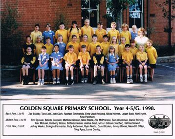
Photograph - GOLDEN SQUARE LAUREL STREET P.S. COLLECTION: PHOTOGRAPH - GSPS YEAR 4-5/G 1998
Coloured photograph of the Golden Square Primary School Year 4-5/G, 1998 class and their teacher. Children are wearing school uniform. Their names are: Back Row, L to R: Zoe Braddy, Tara Lock, Joel Clark, Rachael Simmonds, Elma-Jean Hosking, Nikita Holmes, Logan Buck, Noni Hyett, Arna Packham. Middle Row, L to R: Tim Sproule, Belinda Caldwell, Matthew Gordon, Nikki Steele, Zoe McPherson, Sam Woodman, Daniel Stirling, Alex McLean, Kimberly Rosos, Brittany Hercus, Joshua Boyd, Mrs J Gibson (Teacher), Katrina Stewart. Front Row, L to R: Jeffrey Weeks, Brohgan Parmenter, Ruby Anderson, Ryan Needs, David Doolan, Jimmy Weeks, Meredith O'Neil, Toby Apps, Lorne Dunlop. Oval sketch of the school on the right of the names.education, primary, golden square laurel st p.s., golden square laurel street p.s. collection - photograph - golden square primary school year 4-5/g 1998, zoe braddy, tara lock, joel clark, rachael simmonds, elma-jean hosking, nikita holmes, logan buck, noni hyett, arna packham, tim sproule, belinda caldwell, matthew gordon, nikki steele, zoe mcpherson, sam woodman, daniel stirling, alex mclean, kimberly rosos, brittany hercus, joshua boyd, mrs j gibson (teacher), katrina stewart, jeffrey weeks, brohgan parmenter, ruby anderson, ryan needs, david doolan, jimmy weeks, meredith o'neil, toby apps, lorne dunlop -
 Kew Historical Society Inc
Photograph, J F C Farquhar, Bird's Eye View Looking West, 1891
At the beginning of the 1890s, the Kew businessman and Town Councillor, Henry Kellett, commissioned J.F.C. Farquhar to photograph scenes of Kew. These scenes included panoramas as well as pastoral scenes. The resulting set of twelve photographs was assembled in an album, Kew Where We Live, from which customers could select images for purchase.The preamble to the album describes that the photographs used the ‘argentic bromide’ process, now more commonly known as the gelatine silver process. This form of dry plate photography allowed for the negatives to be kept for weeks before processing, hence its value in landscape photography. The resulting images were considered to be finely grained and everlasting. Evidence of the success of Henry Kellett’s venture can be seen today, in that some of the photographs are held in national collections.It is believed that the Kew Historical Society’s copy of the Kellett album is unique and that the photographs in the book were the first copies taken from the original plates. It is the first and most important series of images produced about Kew. The individual images have proved essential in identifying buildings and places of heritage value in the district.Before true aerial photography became possible, photographers such as J.F.C. Farquhar were compelled to shoot their images from the highest vantage point. Here, it is presumed to be the roof of Xavier College, from which the panoramic view extends west towards the rise of Studley Park. The houses in the foreground face the southern end of Gellibrand Street. Wellington Street is at an angle to the camera with the Queen Street intersection on the near right. The wooden building behind the large horse paddock on the other side of Gellibrand Street is the Kew Recreation Hall, built 1888, demolished 1960. It was reputed to have one of the finest dancing floors in or around Melbourne. The Bowling Green at the rear of the Hall belonged to the Kew Bowling Club. Further west is the Kew Railway Station on Denmark Street, opened to the public in 1887. At this period, much of Studley Park was locked up in large landholdings, dominated by large mansions such as ‘Byram’. Bird's Eye View Looking Westkew illustrated, kew where we live, photographic books, henry kellett, denmark street, kew recreation hall, kew bowling club, wellington street -
 Bendigo Historical Society Inc.
Document - NEW CHUM & VICTORIA LINES OF REEF - NEW CHUM & VICTORIA LETTER & NOTES
Handwritten letter to Mr. Blake with reference to meeting students and the changes in Bendigo. Mentioned are the Log Lock-Up, the Central Deborah Mine, the ex-manager of the mine, Mr. Rowe acting as a guide, Victoria Hill and the Bendigo Pottery. The notes titled ''To replace Around the Goldfields'' mentions the Third Edition, 'Historic Guide to Bendigo', published in 1969 of land reclamation schemes rapidly removing all traces of several mines. Those affected on the New Chum Line of Reef are: The Victoria Consols, Ironbark and Hercules and Energetic. The Sheepshead Line - the Ironbark and Ironbark South. On the Garden Gully Line - The Cornish United, Koch's Pioneer and Confidence Extended. The Paddy's gully Line - The British American, Lansell's Sandhurst (Needle) and the Collman and Tacchi. On the Derby Line - Johnson's No 3 (Nelson) and on the Hustlers Line are the United Hustlers and Redan and the K. K. Mines. Also, a carbon copy of the notes.document, memo, new chum & victoria letter & notes, mr blake, mr hattam, log lock-up, central deborah mine, mr rowe, victoria hill, bendigo pottery, historic guide to bendigo third edition, new chum line of reef, the victoria consols, ironbark, hercules and energetic, sheepshead line, ironbark, ironbark south, garden gully line, cornish united, koch's pioneer, confidence extended, paddy's gully line, the british american, lansell's sandhurst (needle), collman and tacchi. derby line, johmson's no 3 (nelson), hustlers line, united hustlers and redan, k k mines -
 Stawell Historical Society Inc
Tool - Realia, 3 Large wooden boxes, with carpenter, Shipwright tools beloning to G Pert of Stawell
41 items of Woodworking equipment and tools once belongng to G. Pert, 25 Seaby Street, Stawell, Victoria, Australia. Toolbox - Timber box with hinged lid and removable tray. Contents include woodworking tools. L 83.5 x D 41 x 211 cm. Toolbox - Timber Box black, hinged lid, lock. l 88 x H 32 x w 35 cm. Toolbox - tiber box, black metal handle, lock mechanism and tools. L 82 x H 30 x w 29 cm. 1 Plane Smoothing plane, coffin type, 1 Plane, Rabbet moulding plane, 1 Plane - Jack-type Farquarson, blade and wedge. 1 Auger - Ring auger. 1 Auger - Ring Auger, Mathieson. 1 Auger - Ring Auger. 1 Auger - Ring Auger, Matieson. 1 Auger - Ring Auger, Mathieson. 1 Ring Auger, Mathieson. 1 auger - Ring Auger. 1 Auger - Ring auger. 4 Auger - Ring Auger Mathieson. 1 Auger - Nose bit Auger JB & co. 1 Auger - Nose Bit auger. 2 Auger - Nose Bit Auger Mathieson 1 Auger - Nos bit Auger Sheffield. 1 Auger - nos bit auger Mathersion, L Vernes & co. 1 Auger Nosebit auger Matheison. 1 Auger Nose bit Auger Mathieson & Son. 3 Auger - nose bit Auger 1 uger head and ga=shaft. 1 Bit - Bit Double twist Matherison 1 Bit - Bit Double Twist, Barnsly (Broken end) BIt double twist symbol (3 Clovers) Mallet - Caulking Mallet wooden Head, iron Ferrules. Tool - Imporovised tool wooden handle metal ferrules. 1 Screwdriver - wooden handle Sheffield, Thos Well & sons. 1 Gauge - Bevel gauge wooden adjustable. 1 Nippers - wire nippers, pivoted, spring loaded, symbol (footprint) 1 Drill - drill hand operated, wooden handles an some red paint. 1 Maul - Shipwright maul, metal head, replaced handle. dotted embosssed inscription of name h 9.5 x L 63 x w 17 cm2 Black & 1 Brown boxes wiyh G Pert 25 Seaby St Stawell Victoria Australia painted on the lids. -
 Bendigo Military Museum
Uniform - SHIRT, TROUSERS - COMBAT DRESS ARMY, Australian Defence Industries, 2018
AMCU (Australia Multi Camouflage Uniform) Combat Dress colours - light to dark green through to mid to dark brown. Cotton/polyester fabric. Green colour plastic buttons. Nylon and metal zippers. 1. Shirt - polo style, with collar, long sleeves with adjustable velcro and strap at cuff. Two large sleeve pockets with hook and pile closure flaps, one small pocket left sleeve. Half zipper closure. Front and back of shirt - plain khaki colour knit fabric. No manufacturers label. 2. Trousers - waist band with belt loops, two front pockets, two large side pockets with zipper closure, two small pockets with hook and pile flap closure, zipper fly. White colour polyester fabric manufacturers label on right pocket lining. Green cotton fabric pocket lining. At ankle - elastic drawstring with plastic lock clip.Manufacturers information on label - black ink print. 2. "ADA/ MADE IN AUSTRALIA/ NOV 2018/ PO: CC36LD/ NSN:8415 66 161 6292/ SIZE: 34l/ 84-89 cm/^/ NAME/ PM KEYS NO:/ MAIN:/ 75% COTON/ 25% POLYESTER/ STRETCH/ 91% NYLON 9% ELASTANE/ KNEE PADS MUST BE REMOVED BEFORE/ CLEANING. HOT MACHINE/WASH. NO BLEACH/ NO FABRIC SOFTENERS/ MAY BE TUMBLE DRIED HOT/ DO NOT IRON OVER/ STRETCH PANELS OR HOOK AND PILE" .uniform, army, combat dress, amcu -
Clunes Museum
document
INFORMATION ABOUT A STAMP SHOE FROM A CORNISH STYLE SQUARE-HEAD STAMP BATTERY POSSIBLY USED BY PORT PHILLIP MINE, CLUNES, FROM MATTHEW CHURCHWARD, SENIOR CURATOR, ENGINEERING & TRANSPORT, MUSEUM OF VICTORIA LETTER DATED 15 OCTOBER, 1997. THE GOLDFIELDS AND MINERAL DISTRICTS OF VICTORIA. GOLD ITS OCCURRENCE AND EXTRACTION, PLAN OF GOLD MINING COMPANIESINFORMATION RECEIVED REGARDING THE PORT PHILLIP MINE; Including .1 COPY OF ARTICLE 12TH MAY, 1858 FROM "THE ARGUS." MELBOURNE. .2 LETTER FROM "SCIENCEWORKS" TO MR. ALAN KEEBLE DATED 15/10/1997 (3 Pages) .3 SECTION OF MERCURY, TROUGHS, STAKES & STAMPS (Extract taken from publication, The Gold Fields, Mineral Districts of Victoria, by R. Brough Smyth F.G.S, published by Queensberry Hill Press 1979) .4 GOLD. ITS OCCURRENCE AND EXTRACTION (Extract taken from publication, Gold: Its Occurrence and Extraction by Alfred G. Lock F.R.G.S published by E. & F. N. Spon 16 Charing Cross London 1882) .5 PLAN OF GOLD MINING CO'S. CLUNES (Extract taken from Dicker's Mining Record 26/3/1867, page 173. https://trove.nla.gov.au/work/32734386?q&versionId=39944948) local history, mining, company exploration -
 Victoria Police Museum
Police Stations (Ascot Vale)
Ascot Vale is an inner suburb 6 km north-west of Melbourne, Victoria, Australia in the local government area of the City of Moonee Valley. Ascot Vale police station was opened on 31 October 1887 in the Melbourne Police District. From 1900-1905 it was located at 54 Parade, Ascot Vale; from 1910-1925 at 71 St Leonards Road; from 1930-1953 at 37 St Leonards Road. In 1953 it was relocated to government owned premises at 111 Union Road until the police station closed on 1st May 1970 and the Sub-district was divided between Flemington and Moonee Ponds police stations. The former police station was used by the Crime Car Squad until about 1987 when the premises were damaged by fire. The police station at 37 St Leonards Road was described as a six-roomed brick dwelling with slate and iron roof on land measuring 150' x 50'. There was also a bathroom and W.C., wash-house, office and lock-up with one cell. It was staffed by one second-class sergeant and four foot constables. The purpose-built police station at 111 Union Road included a four-roomed residence with the exterior clad in rough cast Conite and a tile roof. There was also a kitchen, bathroom, laundry and separate garage. 4 black and white photospolice stations; ascot vale police station -
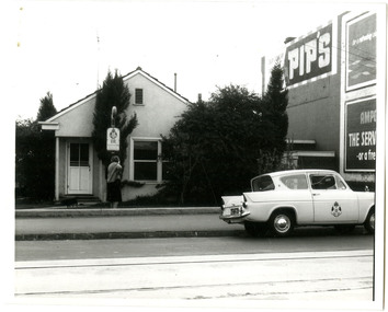
 Kiewa Valley Historical Society
Camera Box Brownie Folding, Six 20 Folding Brownie KodetteII, Circa 1948 to late 1970s
This camera was made for the mobile photographer and the camera manufacturer Kodak was at the peak of production. Mr. George Eastman, the company's founder, who invented roll film, which could withstand the outdoor activities and therefor replaced photographic plates. In 1900, the Box Brownie camera was first released Kodak's motto was' "You push the button, we do the rest," The film used in this camera was Kodak Verichrome 620 introduced in 1936 and only went out of production 2009. This camera was a vintage 1970s one. Between 1963 and 1970 the company sold 50 million of this type of camera. The production of smaller and more user friendly digital cameras, mainly from Japan finally nailed the coffin lid on the Kodak Company. Ironically, one of Kodak's engineers called Steve Sasson, devised a camera that could save images using electronic circuits. The images were transferred onto a tape cassette and were viewable by attaching the camera to a TV screen, however Kodak tried to maintain its photographic film products beyond its "use by date". In1975 Kodak becomes the first company to make a digital camera, however the Japanese manufacturers could make smaller and more compact cameras ending Kodak's monopoly and eventual demise.This particular "box brownie" was used by Margaret Shefford, nee Turner, who with her husband retired, in the 1980s, to Mount Beauty. The camera was purchased in the 197's and used on their cruise to England. The significance of this item is that at the time of its introduction to Mount Beauty the camera was a "state of the art", for general public, camera introduced by an ever increasing influx of retirees. This identifies the Kiewa Valley not only as an attraction for sightseers and overseas tourists but also retirees. The social implications of this trend will continue to provide a broader requirement for medical and other facilities geared up to the requirements of an aging population. As a lot of cities in Australia have increasing levels of violence (mainly drug related) rural "retreats" are becoming more sought after by sections of "the gentle populous"This is a black metal rectangular camera, rounded on the ends and has silver colored fittings(stainless steel) and a small leather handle on hinges the left side (facing the lens). The folding lens and shutter component fold out from the main compartment. Two metal arms swing out and hold the lens and collapsible lens body to the required length. When not in use this collapsible (folding) lens extension is fastened to the main body structure providing security and preventing damage to the folding material. The camera has a collapsible eye piece or view finder at the top end. The right hand bottom end has a cylindrical film wider (polished steel). Inside there are two cylindrical cavities, one holding the roll of unexposed film and the other (winder) end a cylinder onto which the unexposed film is wound through for each picture frame. There is a locking mechanism to hold the folding lens structure to the main box structure. See KVHS 0419B for its carrying caseNo external makings but when the lens is folded out it exposes manufacturing information on metal base around the lens " Kodette II B I shutter"(B= Bulb and I= Instant), underneath this, in larger print, is "'FOLDING 'BROWNIE' SIX - 20" below the lens and in smaller print, "made in Great Britain" and underneath this "by KODAK ltd"kodak kodette ii, folding brownie camera, photography, hobby personal item, tourist gadgets. -
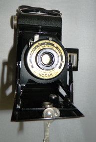
 National Wool Museum
Machine - Shearing Motor, Sunbeam, 1960-69
With more and more woolsheds being connected to power lines, the need for electric shearing gear markedly increased from the 1960s onwards. The greater economy made electric gear an attractive proposition to many graziers. Requiring only an electric shearing motor, for small and medium scale operations, electric shearing motors were a more economical way of shearing a wool clip. The other option for graziers was Overhead shearing gear, which also required an Engine to provide shared power to a row of shearing stations. Still working, this Sunbeam Electric Shearing Motor – Heavy Duty Model, features a slow speed motor totally enclosed for protection against dust and insects. The full bearing down tube is easily removed and stored to be out of the way when not in use (not pictured). Providing 0.5 hp, which is twice the power ever needed for shearing sheep, this buffer allows for fluctuations in voltages that can occur in rural districts. Inventor Frederick Wolseley made the world's first commercially successful power-shearing system in Australia in 1888. US company Cooper, which had been founded in 1843 as a maker of sheep dip, began selling Wolseley equipment in the USA in 1895. The Chicago Flexible Shaft Company successfully entered the power-shearing market a few years later and entered into a joint venture with Cooper. It set up a branch in Sydney and sold shearing sets, and engines to power them, into the Australian market. In 1921 the US parent company, realising it needed to make products whose sales were not as seasonal as those of shearing equipment, made its first household appliances and branded them Sunbeam. In 1933, changes in exchange rates and taxes led the company to manufacture engines and shearing equipment in Australia via subsidiary Cooper Engineering, which changed its name to Sunbeam in 1946. Although most Australians know of this company as a major manufacturer of household appliances, its rural division flourished and retained the Sunbeam name for shearing equipment even after it was taken over by New Zealand company Tru-Test in 2001. This 0.5 horsepower vertical brushed motor air-cooled engine was designed to drive a single shearing plant. From the central cylinder which features a yellow “Sunbeam” sticker, a grey 240v power lead can be found on the left-hand side. A blue capacitor is located next to this power lead. Below, two legs extend and meet to form a foot which is fastened to a wall. On the right-hand side of the engine, a specification plate is located on the central cylinder. A yellow directional arrow sticker is located on the rotating section of the engine below the specification plate (location for photography, this section is designed to rotate and hence this sticker is not fixed in this location). At the rear of the cylinder, a plastic cap with small air cut outs protects the air-cooled engine from contaminants. At the front of the engine, the location for securing the bearing down tube is located. On the right-hand side of the lock for the bearing down tube is the handle, to which a string is often attached for switching the motor on and off by a shearer bent at the waist (not pictured). Sticker. Gold writing. Front of shearing motor “Sunbeam” Plate. Inscribed. Side of shearing motor. “Sunbeam / SHEARING MOTOR / MADE IN AUSTRALIA / 0.5 H.P. / 220/240 V / 1 PHASE A.C. / 4.0 AMPS / 50 C/S. / CONT. RTG. / 1425 R.P.M. / CLASS A INSUL / NO. J244560 / TYPE: NSB5C2/49." sheep sheering, shearing equipment, sunbeam, electric shearing motor -
 Warrnambool RSL Sub Branch
WW2 Field Telephone/Communication Instrument; German
Used in WW2. Basically of german origin and manufacture but 'English' handset suggests capture and use by Australian forces possibly in Middle East Desert warfare.Black Rectangular Metal Box with Lid. Total Height 215mm (with lid closed), Body Height 140mm. Lid Height 75mm.Lid attached by full length Hinge on rear and locking Clip at front.Depth 90mm. Length 275mm. Lid Outside: has overlapping lip to body when closed.Reinforcing metal attachment on left side rolls over to inside of lid and is attached by two screws. Front locking clip is spring loaded and attached to lid by 3 screws. Lid Inside: Flexible metal plate to clip on handset. 2 inscription plates on left and right ends and telephone handset described separately Body Outside:Front: 2 Jack plug points, vertically aligned 85mm from left, 25mm apart either side of mid point of height of bodyprotedted by protective pivot plate. Air vent plate attached with 2 screws adjacent to Jack plug holes (same on Back). Left side at top; metal plate for carry strap (same on right side). carry strap not with item.Right side; hole covered by protective cover plate centred 70mm from base , Wind-Up handle attached (described seoarately. Body Inside: 2/3 filled with visible metal and bakelite components in separate compartment containing unseen working parts. Left side contains morse code key in canvas bag (described separately). Contents Inside Lid. Two schematics of wiring layouts attached to left and right ends. Removable Bakelite handset clipped into postion for carrying, attached cable has 4-pronged attachment connected to main section in body. Contents Inside Body. Most working parts hidden inside metal container. White plastic button 'Pruttaste' is a test button; threaded screws on top for attachments not present.Two pieces of loose wire purpose unknown. Canvas Bag with zip, labelled DD with arrow between (Department of Defence) containing Morse Code Key; wire with large jackplug attachment connected to MC Key through the bag. Jackplug connects via front of body of object. The whole of this item is stored in left inside of body.underside of handset says PRESS KEY WHILE SPEAKING and in smaller font size TELE HD NO 2 -
 Victoria Police Museum
Police Stations (Altona)
Altona is a suburb of Melbourne, 13 km south-west of Melbourne's CBD and located within the City of Hobsons Bay Altona Police Station opened as a temporary police station in 1919 in the Melbourne District. It was on the corner Sargood and Blyth Streets. It was staffed by one 1st Constable. The original police station was in a small room attached to the front of a 5-roomed weather-board dwelling with an iron roof on land measuring 66' x 165'. There was also a kitchen, vestibule, wash-house, office, one W.C. and a lock-up. In 1929 it became part of the Bourke District. On 31 March 1958 it moved into newly built government premises at 51-53 Blyth Street, on the corner of Bent Street. The building consisted of a cream brick veneer police residence and police station with cell. Staff was increased to a Sergeant in Charge and 3 Constables. A new police station was opened in Altona North on 7th October 1979. The Altona Police Station remained as a sub-station for a few a short time until the building was sold. July 2019 - a new police station is being constructed at 1 Galvin Street, Altona. Galvin Street was names after S/C Michael Arthur Galvin, 3651, who was appointed on 5 Jan 1886 and resigned on 4 Dec 1913. He was Werribee Shire President 1926-1927 and 1940-1941 8 black and white photos of new police station, 1963police stations; altona police station -
 Puffing Billy Railway
Large Electric Staff Instrument, Webb-Thompson
Electric staff - Electric staff instruments The staff and ticket system was still too inflexible for busy lines, as it did not allow for the situation where the train intended to carry the actual token was cancelled or running very late. To provide for this, the electric train token system was developed. Each single-line section is provided with a pair of token instruments, one at the signal box at each end. A supply of identical tokens is stored in the instruments, which are connected by telegraph lines. A Staff can be removed from one instrument only if both signalmen co-operate in agreeing to the release. Once a Staff has been removed, another cannot be removed until the token which is "out" is replaced in either instrument. (There are variations on this sequence of events.) By this means, it can be ensured that at any one time, only one token is available to be issued to a driver. Staff belonging to adjacent sections have different configurations to prevent them being inserted into the wrong instrument. Nevertheless, in the Abermule train collision in 1921 and lax working procedures allowed the safeguards provided by the electric Staff system to be circumvented; a driver was handed a Staff for the wrong section, and without reading the information listed on the staff, proceeded on the mistaken belief that the Staff was correct. To prevent this, it became a requirement in the UK for the signals controlling entry to the single line section (starting or section signals) to be locked at danger unless a token has been released from the relevant Staff instrument. Historic - Victorian Railways Electric Staff Instrument Electric Staff Instrument made of Iron , Brass and Glasspuffing billy, electric staff instrument, victorian railways -
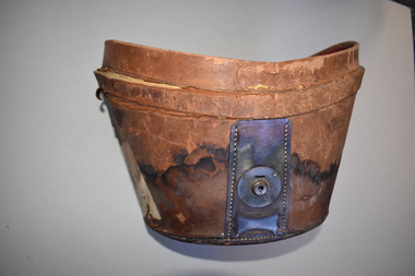
 Bendigo Historical Society Inc.
Clothing - LEATHER HAT BOX, 1887
Leather, oval shaped hat box (in which is stored a men's silk top hat - 11400.834). Lined in blue velvet, and blue silk. Looped handle, 29cm long, attached with 2.5cm circular metal studs - possibly brass. An oval shaped insert, lined with blue velvet and silk, hold the inverted top hat. This hat was owned by John Sargood ( refer enclosed notes) whose initials are marked on trhe hat-box - J.S. - two cms high. An internal strap of black fabric, has a leather tab at one end with a metal key shaped fastener. Unfortunately the other end is broken off. This strap would hold the hat in the cavity. An outer leather strap, 4cm wide passes over the lid, and fastens at a 6.5cm diameter, circular metal disk with key lock. End of this strap is also broken - a piece of leather is inside the hat box. Strap is marked with a two cm high letter H which lines up with the owners initials when closed J.H.S..Sargood Family Notes in Clothing Box 157.costume accessories, male, leather hat box -
 Royal District Nursing Service (now known as Bolton Clarke)
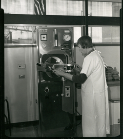
Photograph - Photograph, black and white, c.1967
This photograph is taken in the Sterilizing room in the Royal District Nursing Service (RDNS) Footscray Centre. Sister Short is closing the door of the Autoclave to sterilize equipment and dressings which will then be used by a RDNS Sister when she is visiting a patient in the community. Sterilizing of equipment and dressings were carried out at each RDNS Centre. Royal District Nursing Service (RDNS) supplied sterilized equipment, such as ready set up catheter trays and dressing trays, as well as dressing packs for their trained staff (Sisters) to take to the home when attending to specific patient care. When the Sisters returned to the Centre they washed and set up the trays again ready for re-sterilization. Each RDNS Centre had an Autoclave room and equipment and dressings were sterilized each day.Black and white photograph showing Royal District Nursing Service (RDNS), Sister Margaret Short, who has short dark hair, and is wearing a white gown over her uniform, with the grey peaks seen. She is using the Autoclave in the Sterilizing room. The tall rectangular metal sterilizer stands in the centre of the photograph. There are several small dials and a larger square dial on its upper left, with a long encased thermometer in the centre and a large round dial to its right. Below this is the partly open large metal door of the sterilizing section. A thick horizontal metal piece runs from the left side of the sterilizer, across, and attached at the centre, of the door. Sister Short has her left hand on the turning bar attached to the centre section, and her right hand is on the locking section as she closes the door. Below the door are two switches and several small dials. To the left of the sterilizer is a cabinet, and to the right of Sister Short, eight small wrapped dressing packs are on a shelf. At the rear of the photograph the wall goes halfway up, with windows above.Photographer's Stamp. Quote No. GX 12 Handwritten informationroyal district nursing service, rdns, footscray centre, sterilizing, sister margaret short -
 Mission to Seafarers Victoria
Photograph - Photograph, colour, c. 2001
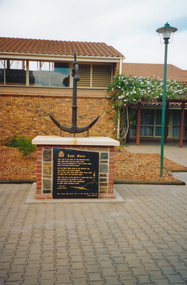
Opened by His Excellency Sir Eric Neal AC CVO on 30 September 2001, the Memorial is located in City Park, Port Pirie, South Australia. The monument commemorates those who were lost at sea while serving with the Merchant Navy. Mr Noel Smith, a resident of Port Pirie, former Merchant Navy seaman and Port Pirie tugboat officer designed the memorial, found the anchor located on the top of the memorial during a dredging operation in a creek near the Nystar plant and wrote the poem inscribed on the main plaque. Front Inscription Lost Ones They live in the curl of the breaking wave, They sing when the sea winds blow, They lay not confined in a land locked grave, Nor in dim dark depths below. Do you hear them laugh in the rippling tide, Call free in the ocean breeze ? Do you see them soar where great gulls glide At peace with the fearsome seas ? They live still in the hearts of those who wait Held strong in the bonds of love 'Til their souls unite and congregate In God`s great harbour above. Noel Smith Merchant Seaman For those who were lost to the depths of the sea Emma Hindmarsh Left Side Inscription Memorial unveiled by His Excellency Sir Eric Neal AC CVO Governor of South Australia and His Worship the Mayor Ken Madigan Port Pirie Regional Council Memorial blessed and consecrated by Right Reverend Garry Weatherill Bishop of Willochra 30 September 2001Colour photograph of the memorial made of an anchor on a bricks and stones base with a black marble plaque titled The Lost Ones. The logo of the Merchant Navy, MN, on the top left corner of the plaque.merchant navy, mn, port pirie, memorial -
 City of Moorabbin Historical Society (Operating the Box Cottage Museum)
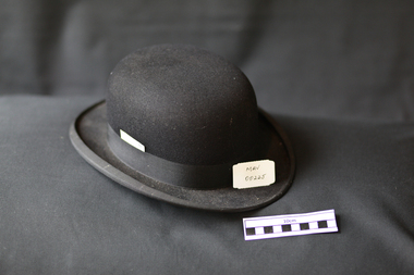
Headwear - Clothing, Bowler Hat black, 20thC
The Bowler hat, characterised by its dome-like crown, was invented in 1849 by a pair of hat-makers: brothers Thomas and William Bowler. They were commissioned by the famous London hat retailer “Lock & Co” to invent a close-fitting, low-crowned hat for their customer Mr. Edward Coke. It would be sturdy and not easily knocked or blown off the wearer’s head. The difference between a Bowler hat and a Derby hat is simply that Bowler hats are British, Derby hats are American. The Bowler / Derby hat was devised in London during a time when the top hat was the upper-class men’s hat of choice and the lower social class wore soft, cloth caps. However, the top hat was impractical and inconvenient for those on horseback as it easily toppled over and was easily damaged. Bowler hats were termed “stiff” hats– they were given a coat of shellac in the construction process and therefore never conformed to the shape of the wearers head. While very stiff, the hat is lined in a beautiful, soft silk to ensure comfort. The Bowler hat marked the first middle ground between formality and casual wear. c1900 The Derby hats were very popular for all classes in USA including criminals like Butch Cassidy & Sundance Kid and c1920 many fashionable women also wore them. In England and Commonwealth the Bowler hat remained popular throughout the 1800s and through the first half of the 1900s, being worn by everyone from politicians, actors, accountants, bankers, and the 'everyman' on the street.The family of Nance Blackman were early settlers in Moorabbin ShireA black felt Bowler hat with cream silk lining and black ribbon bandInside Crown & Band ; The Cobweb Felt / easiest/ fitting / extra light / Inside Band Best Quality / 6111hats, hatters, blackman nance, clothing, suits, fashion wear, bankers, actors, politicians, bowler hats, derby hats, top hats, social classes, moorabbin, cheltenham, bentleigh, brighton, market gardeners, pioneers, early settlers, bowler thomas, bowler william, lock & co. ltd. london, england, america, canada -
 Flagstaff Hill Maritime Museum and Village
Functional object - Bottle Seal, circa 1843-1878
This lead sealing capsule was recovered from the tragic wreck of the sailing ship ‘Loch Ard’. It may have once been on a bottle amongst the ship's cargo, its provisions or the passengers’ personal luggage. It is now part of the John Chance collection. Bottles in the early 19th century were handmade. They were not necessarily uniform in size or shape, so sealing was not always successful. If the bottles were stored they often became contaminated by rats and mice breaking the cork or wax seals, or by insects attracted to the contents if the seal on the bottle leaked. Lead sealing capsules were used from 1843 to overcome this problem. The lead was heated until it was malleable, then moulded by hand to fit over the sealed bottle’s mouth and neck. This was more successful if wire was also used under the capsule for added security (similar to modern champagne bottles). The capsule couldn’t be re-fitted so it was discarded after the bottle was opened. Capsule designs from about 1862 used tin-plated lead foil and often had the inscriptions and trademarks of the content makers on them. Eventually it was found that the lead was toxic. The lead was replaced by tin, aluminium, and later plastic. Today’s home brewers can buy readymade plastic capsules that fit over the bottle then twist to lock it firmly into place and can be re-used. Digs at archaeological sites often reveal lead sealing capsules. These are collected and catalogued. The information gathered from inscriptions, makers’ marks, logos and descriptions of the bottle contents has provided valuable insights into the history and the dating of other items on the sites. This lead sealing capsule was made to seal a handmade glass bottle and is historically significant for representing its invention to solve a preservation and integrity issue with bottle seals in the mid-to-late 19th century. Its design has evolved and is still in use today. This sealing capsule is representative of their historical use of capsules as a tool for dating and interpreting archaeological sites around the world. The sealing capsule is also significant as it was recovered by John Chance, a diver from the wreck of the Loch Ard in the 1960s-70s. Items that come from several wrecks along Victoria's coast have since been donated to the Flagstaff Hill Maritime Village’s museum collection by his family, illustrating this item’s level of historical value. The sealing capsule is also significant for being connected to the wreck of the Loch Ard (1873-1878), which is historically significant to both Victoria and Australia. The loss of the ship has been described as one of the ‘worst shipwreck tragedies’ and is well known in Victoria for the tragic death of 52 out of the 54 lives on board. The Loch Ard wreck's historical significance as a large international passenger and cargo clipper ship has been recognised and it is now registered on the Victorian Heritage Database, VHR S417. The wreck site is labelled as ‘one of Victoria’s most spectacular diving sites’ and the area is a popular tourist site. It is part of Victoria’s Underwater Shipwreck Discovery Trail.Bottle sealing capsule, cylindrical with thin, round top separated from thicker body (taped in place and fragile). Made from grey-white lead, uneven in thickness and shape. Remnants of a thick substance are inside the capsule.flagstaff hill, warrnambool, flagstaff hill maritime museum, maritime museum, shipwreck coast, flagstaff hill maritime village, great ocean road, john chance, loch ard, bottle seal, bottle capsule, handmade bottle, antique bottle, sealing capsule, lead capsule, bottle closure, bottle foil, bottle preservation, bottle finish -
 Chiltern Athenaeum Trust
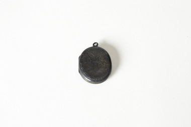
Accessory - Locket
This locket is from the museum's collection of objects relating to Wilfred Clarence Busse. Busse was born in Chiltern in 1898, completed his secondary education as Wesley College in the early twentieth century, and went on to study law at the University of Melbourne. As a lawyer, he spent time in the room of Supreme Court Judge Bernard Cussen (1859-1933). Judge Cussen was popular, known for being just and precise and for completing through statutory consolidation in his spare time. As well as working as a lawyer, Busse wrote historical fiction inspired by his life in Chiltern, these included The Blue Beyond; A Romance of the Early Days in South Eastern Australia" and "The Golden Plague: A Romance of the Early Fifties," which won the T.E.Role gold medal for the best historical novel in 1930 and went on to become a best seller. He was a member of the Chiltern Athenaeum until his death in 1960. The placing of hair in lockets was a common 19th and early 20th century, with Queen Victoria wearing a locket containing a piece of Albert’s hair after his death in 1861. Wearing a loved one’s hair or giving a lock of your hair to someone for wearing, could be a gesture of love and friendship, or of mourning. The tangibility and personal nature of hair made it a common keepsake, especially in cases of high mortality or where family members were separated by oceans without the possibility of air travel. The intention and origin of this locket is currently unknown, but it is likely it was a keepsake of love or mourning, either way, a emotional object. This object artistically significant as an example of late 19th/early 20th century jewellery, and social and spiritual sigifiicance as locket containing a piece of hair, which, regardless of exact intention, imbues it with a strong emotional aura. A small dark metal locket with a decorative leaf pattern on the exterior. The locket contains a small amount of reddish hair, supposedly from a loved one or family member of the original owner, and a degraded image that may have ocne represented a person. busse, w.c. busse, wilfred clarence busse, chiltern, chiltern athenaeum, "the blue beyond, a romance of the early days in south eastern australia”, "the golden plague: a romance of the early fifties.", "the golden plague”, wesley college, university of melbourne, sir leo finn bernard cussen, supreme court of victoria, locket, hair locket, hair jewellery, jewellery -
 National Wool Museum
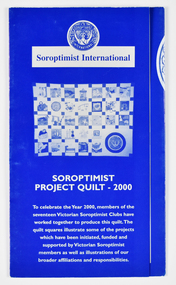
Archive - Soroptimist Project Quilt 2000 Brochure, Soroptimist International, 2000
Brochure to accompany the Soroptimist Quilt Project 2000. The quilt was made by members of seventeen Soroptimist International clubs across Victoria to celebrate the Year 2000. The quilt squares illustrate some of the projects initiated, funded and supported by Victorian Soroptimists as well as illustrations of broader affiliations and responsibilities, including to the UN. Examples include the S.I.A.M. (Soroptimist International Aids Mediation) project by SI Berwick in Northern Thai villages which established industries and health programs for women and girls as viable alternatives to the sex industry. Revegetation of woodlands, wetlands and cleared land by SI Deakin. Donation of toiletries to women's shelters, police lock ups and church emergency centres in the western suburbs of Melbourne by SI Cut Paw Paw. Founded in 1921, Soroptimist International is a global volunteer movement with a network of around 72,000 club members in 121 countries. Advocating for human rights and gender equality, at the heart of Soroptimist International’s advocacy is its work across seven UN Centres, where UN representatives ensure that the voices of women and girls are heard. Memberships work on grassroots projects that help women and girls achieve their individual and collective potential, realise aspirations and have an equal voice in communities worldwide. It has a flourishing Club in Geelong. The quilt has been displayed in Soroptimist Headquarters Victoria at 383 Toorak Road, South Yarra (Soroptimist House) since touring the State of Victoria in 2000. Soroptimist House has been sold with the funds raised to go to furthering the objects of Soroptimism.A3 sized folded brochure printed in blue and white depicting images and text relating to squares of the Soroptimist Project Quilt 2000.front: [printed] SOROPTIMIST / INTERNATIONAL / Soroptimist International / SOROPTIMIST / PROJECT QUILT - 2000 / To celebrate the Year 2000, members of the / seventeen Victorian Soroptimist Clubs have / worked together to produce this quilt. The / quilt squares illustrate some of the projects / which have been initiated, funded and / supported by Victorian Soroptimist / members as well as illustrations of our / broader affiliations and responsibilities.quilt, women, soroptimist, victoria, community, clubs, human rights, gender equality, united nations -
 National Wool Museum
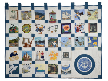
Textile - Soroptimist Project Quilt, Soroptimist International, 2000
The quilt was made by members of seventeen Soroptimist International clubs across Victoria to celebrate the Year 2000. The quilt squares illustrate some of the projects initiated, funded and supported by Victorian Soroptimists as well as illustrations of broader affiliations and responsibilities, including to the UN. Examples include the S.I.A.M. (Soroptimist International Aids Mediation) project by SI Berwick in Northern Thai villages which established industries and health programs for women and girls as viable alternatives to the sex industry. Revegetation of woodlands, wetlands and cleared land by SI Deakin. Donation of toiletries to women's shelters, police lock ups and church emergency centres in the western suburbs of Melbourne by SI Cut Paw Paw. Founded in 1921, Soroptimist International is a global volunteer movement with a network of around 72,000 club members in 121 countries. Advocating for human rights and gender equality, at the heart of Soroptimist International’s advocacy is its work across seven UN Centres, where UN representatives ensure that the voices of women and girls are heard. Memberships work on grassroots projects that help women and girls achieve their individual and collective potential, realise aspirations and have an equal voice in communities worldwide. It has a flourishing Club in Geelong. The quilt was displayed from 2001 until 2023 in Soroptimist Headquarters Victoria at 383 Toorak Road, South Yarra (Soroptimist House) since touring the State of Victoria in 2000. Soroptimist House has been sold with the funds raised to go to furthering the objectives of Soroptimism.Cream patchwork quilt with 31 squares depicting various scenes and motifs. The Soroptimist logo features in the bottom right corner.quilt, women, soroptimist, victoria, community, clubs, human rights, gender equality, united nations -
 Bendigo Historical Society Inc.
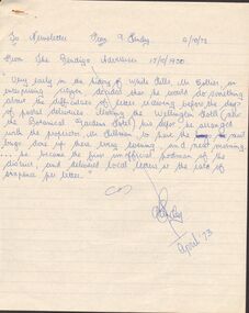
Document - ARTICLES FOR ROYAL HISTORICAL SOCIETY (BENDIGO BRANCH) NEWSLETTER APRIL 1973
Articles for Royal Historical Society (Bendigo Branch) Newsletter - April 1973. 1. From Bendigo Advertiser 15/10/1950 re Bendigo's first unofficial postman, Mr Collier, White Hills. 2.''Inaugurating the New Lock Up'' from Bendigo Advertiser 20/9/1861; mention of Detective Thompson and first inhabitant of Market Square lockup (man named Diamond). 3. Chinese Testimonial (Bendigo Advertiser 27/11/1856) re ring presented to Mr Lysaght as their ''first lawyer''. 4. Bendigo City Coat of Arms - description of this in detail and the representations of the Coat of Arms that are incorrect (eg on three sides of the City Hall) Suggestion - '' see the old Council Chambers'' for ''portraits'' of the (full and correct?) Bendigo Coat of Arms.5. Article from Bendigo Advertiser 4th Jan 1864 re storm of 31/1/1864 (sic) December? Mention of Axe Creek Bridge Hotel of Mr Costelloe. A note from 1973 from author that this hotel might later have been renamed 'The Perseverance' hotel; details of severed storm and flash flood of the day. [Two copies].document, names of bendigo pioneers, bendigo -
 National Vietnam Veterans Museum (NVVM)
Photograph, Gibbons, Denis, Briefing Denis Gibbons
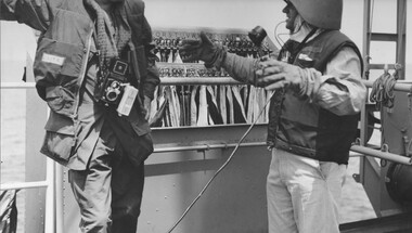
Denis Gibbons (1937 – 2011) Trained with the Australian Army, before travelling to Vietnam in January 1966, Denis stayed with the 1st Australian Task Force in Nui Dat working as a photographer. For almost five years Gibbons toured with nine Australian infantry battalions, posting compelling war images from within many combat zones before being flown out in late November 1970 after sustaining injuries. The images held within the National Vietnam Veterans Museum make up the Gibbons Collection.A black and white photograph of Tonkin Gulf, North Vietnam 25th May 1967 Lt Stanley L Masterton briefs Australian War Correspondent, Denis Gibbons, during his visit to the Australian Guided Missile Destroyer HMAS Hobart. the briefing is taking place on the flag deck, where a large set of signal flags are visible in a ready use locker behind them. the ship, was at that time engaging, with ship to shore gunfire, a major "choke point" (an area where the North Vietnamese were preparing war supplies to be shipped to their units in South Vietnam) at the township of "Vinh". Hobart was expecting, at any moment, counted battery fire from North Vietnamese coastal batteries after radar stations on Hainan Island, Near Haiphong Harbour and at Vinh had locked onto Horart's position with very accurate triangular positioning. Lt Masterton was informing Gibbons of the incoming enemy fire and was worried he (Gibbons) was not wearing a helment, gibbons, most respectfully advised Lt Masterton that he could not operate his cameras with a helmet on. Hobart immediately turned and saled, very rapidly, out to sea as the counter battery fire commencedAustralian War memorial negative: Navy 13503hmas hobart, lt stanley l masterton, denis gibbons, vinh, hainan island, haiphong harbour, gibbons collection catalogue, tonkin gulf, australian war correspondent, australian guided missile destroyer, photograhp, enemy fire -
 Warrnambool and District Historical Society Inc.
Top Hat and Bowler Hat, Woodrow & Sons, Early 20th century (.1 Top Hat)
This top hat, with the initials J.H.H., belonged to John Hunter Henderson, a doctor who practised in Warrnambool from 1904 to 1939. For many years he was a member of the Warrnambool Hospital Board of Management. On his retirement in 1939 he went to live in Melbourne where he died aged 81. The John Hunter Henderson fund was established at the Warrnambool Hospital to develop the training facilities for medical and nursing staff. The bowler hat belonged to his driver (name unknown) and it is presumed that he drove a horse and buggy in the early years of the 20th century. These items are of considerable significance as they are associated with Dr Henderson, a long-serving doctor in Warrnambool and they show the status and comparative affluence of doctors in the first half of the 20th century. .1 This is a black top hat with the crown covered in beaver fur or felt of some kind. The upturned brim is slightly worn on one edge. The crown has a black corded band with a bow on one side. There is a stud with an air hole on the crown. Inside there is a brown leather lining with information on the maker on the inside base and a crown image. .2 This is a bowler hat made of black felt with lining on the edges of black cotton material. The brim is slightly turned up on the sides. The crown has a black corded band with a bow at one side. There is a circle of air holes on the side of the hat. Inside there is leather lining with some information on the maker on the inside base. .3 This is a hat box lid with a leather covering over cardboard. It is a spherical shape with some side damage where the leather is peeling. There is a leather strap handle with a metal buckle. There are remnants of travel labels pasted on to the lid. .4 This is a hat box made of leather with a metal lock on one side. It has remnants of paper travel labels on the sides. Inside the box is an insert made of maroon-coloured cardboard for storing the top hat. This insert has a leather strap to stabilize the hat. There is a name on the base of the box written on a piece of adhesive plaster. .1 J.H.H. Woodrow & Sons Hat Manufacturers to H.M. the King 13 Market St Manchester, 8 Castle St Liverpool, 45 Piccadilly London, 42 Cornhill, London, 11 Gordon St Glasgow, 40 Westmoreland St Dublin, Made in England Lincoln, Stuart & Coy Proprietary Limited Flinders St Melbourne .2 The Tropical Hat .3 Midland Railway .4 Dunedin, F.H.Moreton doctor john henderson, warrnambool, history of warrnambool, top hat -
 Kiewa Valley Historical Society
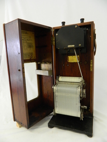
Meter Ammeter Recorder, Circa 1950
This testing voltmeter recorder was last certified by SEC Vic laboratories on the 17/4/77. It was used extensively as mobile recorder placed for periods of one month at locations experiencing unacceptable fluctuations of power. These locations would cover the North East regions of Victoria. They cover voltage drops at domestic and business properties especially those that were experiencing regular fluctuations(daily) at approximately the same time of the day. As the electrical network is required to operate within a set level of voltage, fluctuations outside of this has to be investigated and necessary remedial action taken. This is especially so for rural properties where power "drainage" can occur through animal/bird and tree interference. It can also be the result of defective wiring and overloading at peek operational times (milking machines).This mobile voltage recorder is very significant to the Kiewa Valley because it highlights the difficulties that can occur in maintaining a power supply that experiences fluctuating power demands by the rural industries that it supplies. The requirement of a mobile testing apparatus to cover the various sections in the Kiewa Valley and other rural areas in the northeast region is one of necessity as electricity once connected to a rural property is a labour saving supply as generators on rural properties require a higher degree of maintenance an ultimately at a higher cost. The testing of the SEC Vic supplied electricity to rural properties,those who had previously run on generators, had to be quick and unassuming with certainty of correct supply levels.The mechanism of this voltage recorder has been installed(by the manufacturer) into its own protective wooden box. This box has a front (swing open) lockable section which permits direct access to the installed measuring equipment (for servicing and data collection). The top section of the box has two screw on terminals for access to the machine being tested. This tester has its own inbuilt ink supply facilities and a mechanical clockwork device that unwinds a roll of paper onto a second roll at a rate of 10 mm per hour. The recording chart is marked with time slots against voltage. There is a recording arm which has an ink pen at the end. Both arm and pen carry the ink supply from the ink reservoir, located on the left side of the cabinet door in specially constructed bottle holder( three small bottle capacity). To record a suspect power problem to a home or business establishment the voltmeter is connected to a power supply outlet being tested and wind the recording clockwork mechanism (gives a four week running time). Before leaving the recorder in situ the electrician checks to see if the chart is recording the correct voltage and that the clock mechanism is advancing correctly.On the front of the access "door" at the top a metal label "RECORDING AMMETER" below this "MURDAY SYSTEM" below this "ALTERNATING CURRENT" and below this the manufacturer's registered number "No. 139156" Below this is a metal tag with State Electricity Commission of Victoria Electrical Engineer's Section equipment number "338" Below these tags and above the viewing window is the manufacturer's dtails "EVERSHED & VIGNOLES Led LONDON"sec vic kiewa hydro scheme, alternate energy supplies, alpine feasibility studies temperature, rainfall, power outages -
 National Wool Museum
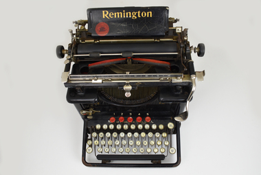
Functional object - Typewriter, Remington Typewriter Company, c.1925
This Remington No.12 typewriter is of the typebar, front-strike class. It was made by the Remington Typewriter Company of Ilion, New York, U.S.A. in about 1925. The Model No. 12 was introduced in 1922 and was one of the first 'visible writer' machines, in which the typed characters were visible to the operator. Previous models were of the upstrike class in which the characters were typed on the underside of the platen. To see what had been typed the operator had to raise the platen, meaning the typist was typing blind much of the time. This machine was used by Margaret Ganly née Burn in the 1930s. It was purchased for her by one of the sons of William Pride, a famous saddle maker in Geelong, William was Margaret’s grandfather. The typewriter was donated with original sales receipt and servicing tools. Margaret worked at Dennys for 7 years during the 1930s. The typewriter is accompanied with a story written by Margaret about her time working at the company. Margret married Jack Ganly, a fellow employee of Dennys. The Ganly name was well known within Dennys, with three generations of the Ganly family working at the company. WORKING CONDITIONS & OFFICE WORK DUTIES. Written by Margaret Burn in 2021. Worked at Dennys Lascelles in the 1930s. In the 1930s coming out of the Depression, jobs were hard to come by and had to be clung to by efficiency and subserviency. There was no union to protect workers – bosses could be tough and rough. Dennys Lascelles revolved around fortnightly wool sales in the “season” – September to May. Sale day was always a day of suppressed excitement. Preparation from a clerical point of view was complete and we now awaited the aftermath of the actual wool auction. The building teemed with people. There were country people down to see their wool sold, buyers of many nationalities, or from the big cities, who were coming in and out of the building all day. Their role was to inspect the acres of wool bales displayed on the show floors; however, caterers were present to feed clients, and there was plenty of social interactions on top of business. The office staff did not go home but waited until the first figures came back from the wool sales and the machines went in to action, both human and mechanical, preparing the invoices for the buyers’ firms. This comprised of lists of lot numbers, weights, prices per lb., and the total prices paid. A lot of this was done by old-school typewriters, making this work a big, heavy, tiring job. Before the finished lists could be dispatched, they were collated on an “abstract”. The lists had to balance with the catalogue from which the invoices had been prepared. This never happened automatically. All the paperwork had to be split up amongst pairs of workers and checked until discrepancies were found. This would happen until midnight but occasionally went until 2 or 3 am. Once complete, the invoices could then be rushed off to the buyers’ firms usually in Melbourne, and hire cars took the staff home. It was back on the job the next morning, usually around 8.30. The office hours varied according to the size of the sale and work involved. Some days started as early as 8 and could finish around 5.30. The second phase of work began with the account sales to be prepared for the sellers of the wool. These detailed all the weights, descriptions of wool, brands, and prices. One Sales account could have multitudes of lot numbers, all needing to be individually described. Various charges needed to be deducted such as finance for woolpacks, extra stock, or farmers who were given a loan to live on during the season. Details of how payment was to be made was also noted, whether the seller was to be paid by cheque, to a bank, or credited to their account with the company (which often left the seller still in debt). For a couple of months in the winter, things were quieter when staff took holidays and were sometimes given afternoons off. But there were still weekly skin sales and stock sales around the state. The annual end of June figures to be prepared for a big company like Dennys with branches all around the state also kept the staff busy. In good years there was sometimes a bonus. On sale days there was a bar open for the clients and wool buyers. This added to the excitement for the young girls, who were strictly barred from using it, but somehow managed to sneak a gin and tonic. This is how I had my first ever, before the evening meal. There was also the romantic notion in some minds, with all the influx of males, that some of us might end up on a wealthy station, or be noticed by an exotic buyer. To my knowledge, this never happened at Dennys Lascelles Limited. Group staff photo at Dennys Lascelles Limited. Margaret Burn. Age 18 or 19. Jack Ganly (Margaret’s future husband). 22.The typewriter has a black painted metal frame. The top section of the typewriter consists of a cylindrical platen on a carriage featuring plated metal fittings. A curved folding paper guide sits behind the platen and moves on the horizontal axis when the user types on the keyboard. A horizontal semicircular type basket with typebar links the top section to the lower keyboard. The ink ribbon is carried between two spools on a horizontal axis, one on each side of the type-basket. At the rear, a paper tray features gold lettering which reads ‘Remington’. At the front, a four-row QWERTY keyboard is found with 42-character keys total. 'SHIFT LOCK' and 'SHIFT KEY' are to the left of the keyboard, 'BACK SPACER' and 'SHIFT KEY' to the right. All keys are circular, white with black lettering. At the top of the keyboard are five circular red keys with the numbers 1-5 displayed behind their respective keys. A Spacebar is found along the front of the keyboard. The typewriter is accompanied by a cardboard box. This box contains the original sales receipt, on blue paper with grey lead handwriting. It also contains spare parts, a spare ribbon stretched between two spools, and cleaning tools such as brushes of differing sizes. Serial Number. Engraved. "LX45395" Gold lettering. Paper tray. “Remington” Gold Lettering. Behind keyboard. “Made in Ilion, New York, U.S.A. Gold Lettering. Mirrored both sides of type-basket. “12”remington, dennys lascelles ltd, worker conditions 1930s -
 Bendigo Historical Society Inc.
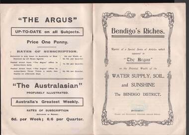
Book - BOOK: BENDIGO'S RICHES
Small booklet titled 'Bendigo's Riches'. Reprint of a Special Series of Articles which appeared in 'The Argus' on the Potential Wealth of the Water Supply, Soil, and Sunshine of The Bendigo District. Printed by Wilson and Mackinnon, Printers, Collins Street. Booklet mentions the potential wealth of Bendigo's Water, Soil and Sunshine; Orchards, Dairying, Tomato Growing, Fruitgrowing, Land, and Water Supply. Also discussed are Antiquated Mining Regulations, City Trust suggested, and its Advantages, Opportunities, 'The Argus' suggestions endorsed, Mine-owner's Opinion, The Mayor of Bendigo's Opinion, Statement by Strathfieldsaye Shire Secretary, Locked-up Area Useless for Timber, Shire Appeals for Unlocking the Land, 'The Argus' Thanked, Bendigo Chamber of Commerce, Bendigo City Council and Preserving Factory at Bendigo. Photos include: Irrigated pastures, rye-grass and clovers on Mr James Cumming's Farm; Irrigating Tomatoes on Mr Elliot Borley's Farm, White Hills; Junction of Huntly and White Hills Irrigation Channels; Packing Tomatoes at Mr B. Puig Y. Ventura's Garden, White Hills; and Tomato Patch on the Holding of Mr T. L. Sweeny, Jun. Back of the booklet has subscription rates and price of The Argus. Missing 8/07/2021place, land, agricultural, book - bendigo's riches, the argus, wilson and mackinnon, councillor carolin, james cumming, dairying, mr elwood mead, tomato growing, mr b puig y ventura, mr elliot borley, fruitgrowers, bendigo fruitgrowers' co-operative society, mr w a hamilton ex-mla, upper coliban, coliban system, antiquated mining regulations, lands department, chaffey bros, mr g h crawford, mine-owners' association, councillor andrew, mr baillieu, miners' association, agricultural society, sir thomas bent, strathfieldsaye shire, mr r b brennan, mr t l sweeny jun, bendigo sewerage farm, councillor osborne, councillor lowndes, councillor t r long, bendigo chamber of commerce, bendigo city council, councillor andrew, councillor h a ross, councillor wilkie, h m leggo and co -
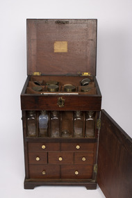 Mission to Seafarers Victoria
Furniture - Volum Medicine chest
This chest is the typical mid-18th century model. Thought to have belonged to captain James Volum.A medicine chest was a necessity for all sea journeys. Sometimes surgeons were onboard ships if there were passengers but on merchant ships, the captain had to be able able to look after his crew. A medium size mahogany cabinet with four protruding feet, small free hinged handles on left and right sides which are positioned approximately 5/8ths up from the bottom of the item, these handles can hinge 100 degrees upwards. The front and back 6/8ths of the cabinet can hinge open, as can the top of. Both front and back doors can be locked closed with their own respective hook latch which is on both sides of the cabinet. The top lid can be locked by interacting with a metallic keyhole which is present on the front of the cabinet close to the top. Revealed by opening the top lit is storage location with two rows of three storage spaces and one row of four. Revealed by opening the front door, is a single shelf with six divided locations for an equal number of glass containers, though only five remain in complete form. Below this self are three rows of drawers of differing dimensions, each with a small white knob. There are two drawers of equal width in the first row. Each drawer has four equally divided sliding pieces on its top face. When removed, these lids reveal a respective small space. Present on small paper labels on each of these lids are identifiers of the material which was stored. There are three equally sized drawers in the second row, which are less wide than the previous row. Only two of the drawers in this row have lids, of which each only have a single lid which covers a single compartment, each of these have a single label on them. The middle drawer contains a small glass mortar and pestle which are restrained by small wooden fixtures within the drawer. There are two drawers of equal width and greater height than any of the previous drawers in the third row. The first drawer has a single compartment containing multiple vials of varying dimensions, some of which feature a paper label with a respective inscription. Some of these vials are broken. In the second drawer has no lid which covers its four equally sized glasses. These are restricted by a wooded piece with four circular cut-outs. Revealed by opening the back door are two equally sized and spaced shelves which both have four divided locations which are filled by eight respective glass containers. These glass containers are of similar design to those in the front compartment but are larger. Some of these glass jars have paper labels like those found on previous glass containers.Label on top lid:volum collection, medecine chest, portable furniture, geelong, peterhead, scotland, captain, seafaring, whaling, london, bishopsgate, old gravel lane, london docks, tobacco dock, james burrows