Showing 1432 items matching "planning development"
-
 Ballarat Tramway Museum
Document - Photocopy, M. Sayers, "The Development of Ballarat's Electricity Supply", 2000?
Photocopy of an article in the State Electricity Commission of Victoria Magazine, Contact, Vol 3, No. 2, Aug 1938 titled "The Development of Ballarat's Electricity Supply". Two A3 sheets. The item with six photographs details the history of the development of Ballarat's Power Supply. Details development of the initial power supply in Dana St, the take over by ESCo, DC power initially, expansion, introduction of AC in 1925 to Ballarat, the takeover by the SEC in 1934, changeover from DC to AC, expansion to outlying areas, Buninyong, Creswick etc. Gives description of installed plan, boilers, storerooms and the stores systems. Has photos of the Dana St. building, Ballarat A power station, Ljungstrom Turbo Alternator and three of the stores area. Record revised 3/4/2019 to add digital images with those from Andrew Cook CD. Each item had a thin strip of paper attached by staple to the top left hand corner, giving the Vol. No. details.On rear of 2nd A3 sheet in blue ink details of contact with the BTM by M. Sayers prior to sending the material.trams, tramways, sec, power supply, power station, ballarat a power station, esco -
 Moorabbin Air Museum
Manual (item) - CAC Production of Turbine and Compressor Blades, Development Plan Production of Compressor & Turbine Blades at CAC
... Development Plan Production of Compressor & Turbine Blades... Moorabbin melbourne CAC Collection Development Plan Production ...CAC Collection -
 Ballarat Tramway Museum
Newspaper, The Courier Ballarat, "Tramway museum on track" - "funding sought for tourist attraction development", 28/03/2014 12:00:00 AM
Newspaper clipping from The Courier, Friday 28/3/2014, page 7, titled "Tramway museum on track" - "funding sought for tourist attraction development", with an image of the Museums plan for the addition to the existing building. Includes information provided by Paul Mong, business case, creating jobs. Two copies collected.On front or rear of the cutting, information re dates etc.btm, museum -
 Bendigo Historical Society Inc.
Document - PHOTO RECORD OF THE FORMER LYRIC THEATRE
Spring bound photographic record of the former Lyric Theatre, 19 High Street (Charing Cross), Bendigo, by Bruce Trethowan, B.arch, FRAIA, dated June, 2005. A letter in the front of the document mentions as part of the Bendigo Bank Development, it was necessary to demolish the former Lyric Theatre. Before doing so, the Bank commissioned a heritage architect to produce a photographic record of the building. It is addressed to Mr Jim Evans, President, Bendigo Historical Society and dated 10 August 2005. The beginning has the Historical Background, Building Description and three pages of Plans and Elevations. There are sixty colour photographs of the building depicting the front outside of the building, other outside photos and a number of the interior.buildings, commercial, former lyric theatre, photographic record of the former lyric theatre, bruce trethowan, gallagher jeffs consulting, gallagher jeffs pty ltd, jim evans, bendigo bank development, ted gallagher, richard hasseldine, city of greater bendigo planning department, keogh & austen, state savings banks, sydney smith and ogg, godfrey and spowers, colonial life building, johnson morley warehouse, j g austen, muioof building eaglehawk, george austen, backhaus building, allawah, william cowling, taylor, soilleux, overend, plaza theatre, backhaus trust, princess theatre, the annals of bendigo vol 8 p163, the annals vol 8 p180, fernwood women's health club, bendigo real estate -
 Queenscliffe Maritime Museum
Plaque - Plaque, brass inscribed with Naval countermine information
Found in garden shed of Mr Harry Barratt [WWI Gallipoli] and donated by his grandson. In 1877 Swan island was designed to defend shipping in Port Phillip and Hobson's Bays. The scheme, involving massive expenditure, comprised a forward defence system of forts at Port Phillip heads dominated by Fort Queenscliff and South Channel Fort (artificial island), and a network of coastal batteries. Some development of fortification had occurred in the 1850s, but it was the impetus of the Jervois-Scratchley reports which led to major work being undertaken in the 1880s. The overall defence plan involved a combination of guns, mines (known as electric torpedo) and ships to defend the entrance to Port Phillip Bay. Swan Island Fort would be used to protect the minefields in the harbour, Naval observation countermine charge 500lbs wet G.C Standard mine from 1877 to 1905 when charge was removed and mines used as buoys. In 1914 mines were recharged and used for defensive mining until Armistice.Brass plaque inscribed with information on naval countermineNaval observation or countermine charge 500lbs wet G.C. Standard mine from 1877 to 1905 when charge was removed and mines used as buoys. In 1914 mines were recharged and used for defensive mining until the Armistice.sea mine, plaque, pre wwi, naval countermine, swan island -
 Bendigo Historical Society Inc.
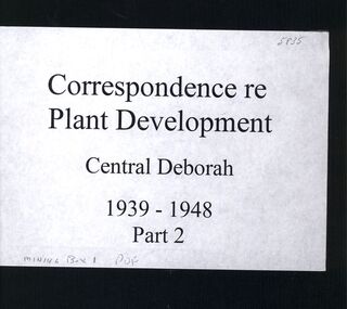
Book - CENTRAL DEBORAH MINE CORRESPONDENCE RE PLANT DEVELOPMENT PART 2
Black folder containing photocopied documents pertaining to the setting up and running of the Central Deborah Mine, Bendigo. 1939 - 1948. Original copies held in McColl,Rankin & Stanistreet Collection. Application for Permit. Ministry of Post War Reconstruction. War Organisation of Industry. Quotes, Tenders. Hume & Iser. T.J Jorgensen. Electricity Supply Department. Saunders & Ross. District Telephone Office. R Toma. Stock Exchange. Building Site Plan. Abbott Supply Co. F.W. Milne & Son. The Golden City Agricultural Implements. Department of Labour and National Service.Miller & Co. Thompson Engineering and Pipe Co. Gold Boring and Prospecting. Costs. J.l. Howard. A.J. William Electrical Instruments.bendigo, mining, central deborah gold mine -
 Bayside Gallery - Bayside City Council Art & Heritage Collection
Map - print, Melbourne and Metropolitan Board of Works, Interim development order: Brighton, Moorabbin and Sandringham, 1959
... Town Planning cartographic material Interim development order ...The Melbourne and Metropolitan Board of Works (now Melbourne Water) was established in 1891. From that time, as part of their work laying water and sewerage connections, they created detailed plans of houses and other buildings in the Melbourne metropolitan area. In 1956 it acquired powers to construct and maintain highways and bridges, protect and improve the foreshores and create and maintain parks within the metropolitan region. This Interim development order comprises part of the municipalities of Brighton, Moorabbin and Sandringham and was made on 20 October 1959.brighton, moorabbin, sandringham, melbourne and metropolitan board of works, map, town planning, cartographic material, interim development order, bayside -
Bendigo Historical Society Inc.
Letter - Kangaroo Flat Gold Mine Collection: Mining Lease 1345
One page letter from Department of Industry, Technology and Resources to George H. White, Development Manager, Western Mining Corporation, Eaglehawk, re mining lease no. 1345, Bendigo Gold Project. Approval of a working proposal for evaluation at the Carshalton Shaft has been sought by Western Mining Corporation. The Department of Industry, Technology and Resources 'hereby approves the proposed underground exploration at South Carshalton Shaft including the dewatering activities outlined in your report dated July 1987'. The Minister for Planning, Jim Keenan, has exempted the exploration works from the Environment Effects Statement. Shire of Strathfieldsaye have issued a planning permit. western mining corporation, department of industry, technology and resources, dewatering, carshalton shaft, environment effects, shire of strathfieldsaye -
 Kew Historical Society Inc
Plan, Melbourne & Metropolitan Board of Works : Borough of Kew : Detail Plan No.1576, 1904
The Melbourne and Metropolitan Board of Works (MMBW) plans were produced from the 1890s to the 1950s. They were crucial to the design and development of Melbourne's sewerage and drainage system. The plans, at a scale of 40 feet to 1 inch (1:480), provide a detailed historical record of Melbourne streetscapes and environmental features. Each plan covers one or two street blocks (roughly six streets), showing details of buildings, including garden layouts and ownership boundaries, and features such as laneways, drains, bridges, parks, municipal boundaries and other prominent landmarks as they existed at the time each plan was produced. (Source: State Library of Victoria)This plan forms part of a large group of MMBW plans and maps that was donated to the Society by the Mr Poulter, City Engineer of the City of Kew in 1989. Within this collection, thirty-five hand-coloured plans, backed with linen, are of statewide significance as they include annotations that provide details of construction materials used in buildings in the first decade of the 20th century as well as additional information about land ownership and usage. The copies in the Public Record Office Victoria and the State Library of Victoria are monochrome versions which do not denote building materials so that the maps in this collection are invaluable and unique tools for researchers and heritage consultants. A number of the plans are not held in the collection of the State Library of Victoria so they have the additional attribute of rarity.Original survey plan, issued by the MMBW to a contractor with responsibility for constructing sewers in the area identified on the plan within the Borough of Kew. The plan was at some stage hand-coloured, possibly by the contractor, but more likely by officers working in the Engineering Department of the Borough and later Town, then City of Kew. The hand-coloured sections of buildings on the plan were used to denote masonry or brick constructions (pink), weatherboard constructions (yellow), and public buildings (grey). Development in the 20th century has irreparably altered that part of Kew represented in this plan. In the block bounded by Cotham Road, Charles Street, Wellington Street and Gellibrand; just one house standing in 1903 remains. This block included two of the most historic houses in Kew: ‘Ordsall’ (later ‘Southesk’) and ‘Madford’ (previously ‘Elm Lodge’). Ordsall was the home of the second chairman of Kew, John Halfey. It contained some of the most significant interior murals in Kew, created for Halfey by artists working for Cullen & Co. It was demolished in 1960 to make way for the Kew Civic Centre. Elm Lodge had been built for William Siddeley in ca. 1864. Arthur Septimus King purchased it in 1874. The lower paddocks of Madford were sold in 1905 by his wife to the Borough of Kew and, after landscaping by George and Thomas Pockett, opened as the Alexandra Gardens in 1908. Elm Lodge/Madford was in 1922 to become St. Anthony’s Home for Little Children before its subsequent demolition in the 1980s.melbourne and metropolitan board of works, detail plans, maps - borough of kew, mmbw 1576, cartography -
 Kew Historical Society Inc
Plan, Borough of Kew Detail Plan No.1577, 1904
The Melbourne and Metropolitan Board of Works (MMBW) plans were produced from the 1890s to the 1950s. They were crucial to the design and development of Melbourne's sewerage and drainage system. The plans, at a scale of 40 feet to 1 inch (1:480), provide a detailed historical record of Melbourne streetscapes and environmental features. Each plan covers one or two street blocks (roughly six streets), showing details of buildings, including garden layouts and ownership boundaries, and features such as laneways, drains, bridges, parks, municipal boundaries and other prominent landmarks as they existed at the time each plan was produced. (Source: State Library of Victoria)This plan forms part of a large group of MMBW plans and maps that was donated to the Society by the Mr Poulter, City Engineer of the City of Kew in 1989. Within this collection, thirty-five hand-coloured plans, backed with linen, are of statewide significance as they include annotations that provide details of construction materials used in buildings in the first decade of the 20th century as well as additional information about land ownership and usage. The copies in the Public Record Office Victoria and the State Library of Victoria are monochrome versions which do not denote building materials so that the maps in this collection are invaluable and unique tools for researchers and heritage consultants. A number of the plans are not held in the collection of the State Library of Victoria so they have the additional attribute of rarity.Original survey plan, issued by the MMBW to a contractor with responsibility for constructing sewers in the area identified on the plan within the Borough of Kew. The plan was at some stage hand-coloured, possibly by the contractor, but more likely by officers working in the Engineering Department of the Borough and later Town, then City of Kew. The hand-coloured sections of buildings on the plan were used to denote masonry or brick constructions (pink), weatherboard constructions (yellow), and public buildings (grey). MMBW Plan No.1577 includes some of the most significant houses in Kew: Herbert Henty’s ‘Roxeth’ (now part of Trinity Grammar), ‘Butleigh Wooton’, ‘Bokara’ and ‘Harrow’. It also includes the streets that have since changed their names. That part of College Parade linked to Glenferrie Road is now named College Place, College Parade now extends further north, and Charles Street did not yet reach Barkers Road. Roxeth is one of a number of Henty houses in Kew. Herbert Henty made his home here and was elected a member of Kew Municipal Council in 1864 and mayor in 1868-69. Walter Henry Serle, of Harrow served in the First World War. He was awarded the Military Medal ‘’For conspicuous bravery and devotion to duty. On 29th September near BELLICOURT he showed the greatest bravery and determination when his platoon was attacked by enemy bombing parties. It was due largely to his personal efforts that all the attacks were repulsed. Until wounded, his utter disregard of personal safety and boldness in dealing with the attacks were the means of saving the situation and were an inspiring example to his men.’melbourne and metropolitan board of works, detail plans, maps - borough of kew, mmbw 1577, cartography -
 Kew Historical Society Inc
Plan, Melbourne & Metropolitan Board of Works : Borough of Kew : Detail Plan No.1578, 1904
The Melbourne and Metropolitan Board of Works (MMBW) plans were produced from the 1890s to the 1950s. They were crucial to the design and development of Melbourne's sewerage and drainage system. The plans, at a scale of 40 feet to 1 inch (1:480), provide a detailed historical record of Melbourne streetscapes and environmental features. Each plan covers one or two street blocks (roughly six streets), showing details of buildings, including garden layouts and ownership boundaries, and features such as laneways, drains, bridges, parks, municipal boundaries and other prominent landmarks as they existed at the time each plan was produced. (Source: State Library of Victoria). This plan forms part of a large group of MMBW plans and maps that was donated to the Society by the Mr Poulter, City Engineer of the City of Kew in 1989. Within this collection, thirty-five hand-coloured plans, backed with linen, are of statewide significance as they include annotations that provide details of construction materials used in buildings in the first decade of the 20th century as well as additional information about land ownership and usage. The copies in the Public Record Office Victoria and the State Library of Victoria are monochrome versions which do not denote building materials so that the maps in this collection are invaluable and unique tools for researchers and heritage consultants. A number of the plans are not held in the collection of the State Library of Victoria so they have the additional attribute of rarity.Original survey plan, issued by the MMBW to a contractor with responsibility for constructing sewers in the area identified on the plan within the Borough of Kew. The plan was at some stage hand-coloured, possibly by the contractor, but more likely by officers working in the Engineering Department of the Borough and later Town, then City of Kew. The hand-coloured sections of buildings on the plan were used to denote masonry or brick constructions (pink), weatherboard constructions (yellow), and public buildings (grey). MMBW Plan No.1578 is significant in that it defines the extent of two private schools: Xavier College and Kew High School (now part of Trinity Grammar) by 1904. In relation to the latter, the plan clarifies which buildings the High School operated from behind the mansion ‘Molina’. Established in 1902, Trinity Grammar was to later lease and subsequently buy Molina (now ‘Merritt House’) and ‘Elsinore’ (now ‘Roberts House’). Xavier College had been established in 1872. This 1904 plan delineates the West Wing and the Great Hall (built in 1890).melbourne and metropolitan board of works, detail plans, maps - borough of kew, mmbw 1578, cartography -
 Kew Historical Society Inc
Plan, Melbourne & Metropolitan Board of Works. Borough of Kew Detail Plan No.1579, 1904
The Melbourne and Metropolitan Board of Works (MMBW) plans were produced from the 1890s to the 1950s. They were crucial to the design and development of Melbourne's sewerage and drainage system. The plans, at a scale of 40 feet to 1 inch (1:480), provide a detailed historical record of Melbourne streetscapes and environmental features. Each plan covers one or two street blocks (roughly six streets), showing details of buildings, including garden layouts and ownership boundaries, and features such as laneways, drains, bridges, parks, municipal boundaries and other prominent landmarks as they existed at the time each plan was produced. (Source: State Library of Victoria). This plan forms part of a large group of MMBW plans and maps that was donated to the Society by the Mr Poulter, City Engineer of the City of Kew in 1989. Within this collection, thirty-five hand-coloured plans, backed with linen, are of statewide significance as they include annotations that provide details of construction materials used in buildings in the first decade of the 20th century as well as additional information about land ownership and usage. The copies in the Public Record Office Victoria and the State Library of Victoria are monochrome versions which do not denote building materials so that the maps in this collection are invaluable and unique tools for researchers and heritage consultants. A number of the plans are not held in the collection of the State Library of Victoria so they have the additional attribute of rarity.Original survey plan, issued by the MMBW to a contractor with responsibility for constructing sewers in the area identified on the plan within the Borough of Kew. The plan was at some stage hand-coloured, possibly by the contractor, but more likely by officers working in the Engineering Department of the Borough and later Town, then City of Kew. The hand-coloured sections of buildings on the plan were used to denote masonry or brick constructions (pink), weatherboard constructions (yellow), and public buildings (grey). While MMBW Plan No.1579 does not include many buildings, those that it does show are significant to Kew’s history. These include the ‘Kew [Railway] Station’ in Denmark Street and the ‘Recreation Hall’ and rear courts off Wellington Street. The plan shows the outline of the Recreation Hall, constructed in 1880, at the rear of which is listed a bowling green, two tennis courts, a ‘skittle alley’ and a pavilion. When the Hall was first built, the Kew Cricket Club occupied an adjacent ground, however in 1885 this was acquired by the State Government as the future location of the Kew Railway Station. The Plan also shows a single oval at Xavier College. This oval was completed in 1883. One of the current ovals conforms to this oval’s original shape and position in the school grounds.melbourne and metropolitan board of works, detail plans, maps - borough of kew, mmbw 1579, cartography -
 Kew Historical Society Inc
Plan, Melbourne and Metropolitan Board of Works, Borough of Kew : Detail Plan No.1580, 1904
The Melbourne and Metropolitan Board of Works (MMBW) plans were produced from the 1890s to the 1950s. They were crucial to the design and development of Melbourne's sewerage and drainage system. The plans, at a scale of 40 feet to 1 inch (1:480), provide a detailed historical record of Melbourne streetscapes and environmental features. Each plan covers one or two street blocks (roughly six streets), showing details of buildings, including garden layouts and ownership boundaries, and features such as laneways, drains, bridges, parks, municipal boundaries and other prominent landmarks as they existed at the time each plan was produced. (Source: State Library of Victoria)This plan forms part of a large group of MMBW plans and maps that was donated to the Society by the Mr Poulter, City Engineer of the City of Kew in 1989. Within this collection, thirty-five hand-coloured plans, backed with linen, are of statewide significance as they include annotations that provide details of construction materials used in buildings in the first decade of the 20th century as well as additional information about land ownership and usage. The copies in the Public Record Office Victoria and the State Library of Victoria are monochrome versions which do not denote building materials so that the maps in this collection are invaluable and unique tools for researchers and heritage consultants. A number of the plans are not held in the collection of the State Library of Victoria so they have the additional attribute of rarity.Original survey plan, issued by the MMBW to a contractor with responsibility for constructing sewers in the area identified on the plan within the Borough of Kew. The plan was at some stage hand-coloured, possibly by the contractor, but more likely by officers working in the Engineering Department of the Borough and later Town, then City of Kew. The hand-coloured sections of buildings on the plan were used to denote masonry or brick constructions (pink), weatherboard constructions (yellow), and public buildings (grey). The area represented in this detail plan has undergone significant change during the 20th century. The widening of High Street in the 1930s and 1950s involved the shops on the south side of High Street being demolished and later rebuilt to fit the widened street. Another significant loss was the mansion ‘Drayton’ fronting Wellington Street, owned at this stage by Susannah Fenton. Her family name would later to be given to Fenton Way, which was to be built over the grounds of the house following its demolition. The plan of the garden is particularly interesting, containing a batten dome fronting Wellington Street, an ornamental pond, a fountain and a brick and glass conservatory. The notes by the plumbing contractor on this plan are particularly detailed. Pink borders delineate the ownership of the varying parcels of land. Some of the better known owners listed include the real estate agent Cr. Henry de Castres Kellett (bt) and John Padbury, the funeral director. This particular plan provides a clear view of the configuration of the Kew Junction in 1903 and the commercial buildings that surrounded it.melbourne and metropolitan board of works, detail plans, maps - borough of kew, mmbw 1580, cartography -
 Kew Historical Society Inc
Plan, Melbourne & Metropolitan Board of Works : Borough of Kew : Detail Plan No.1581, 1904
The Melbourne and Metropolitan Board of Works (MMBW) plans were produced from the 1890s to the 1950s. They were crucial to the design and development of Melbourne's sewerage and drainage system. The plans, at a scale of 40 feet to 1 inch (1:480), provide a detailed historical record of Melbourne streetscapes and environmental features. Each plan covers one or two street blocks (roughly six streets), showing details of buildings, including garden layouts and ownership boundaries, and features such as laneways, drains, bridges, parks, municipal boundaries and other prominent landmarks as they existed at the time each plan was produced. (Source: State Library of Victoria)This plan forms part of a large group of MMBW plans and maps that was donated to the Society by the Mr Poulter, City Engineer of the City of Kew in 1989. Within this collection, thirty-five hand-coloured plans, backed with linen, are of statewide significance as they include annotations that provide details of construction materials used in buildings in the first decade of the 20th century as well as additional information about land ownership and usage. The copies in the Public Record Office Victoria and the State Library of Victoria are monochrome versions which do not denote building materials so that the maps in this collection are invaluable and unique tools for researchers and heritage consultants. A number of the plans are not held in the collection of the State Library of Victoria so they have the additional attribute of rarity.Original survey plan, issued by the MMBW to a contractor with responsibility for constructing sewers in the area identified on the plan within the Borough of Kew. The plan was at some stage hand-coloured, possibly by the contractor, but more likely by officers working in the Engineering Department of the Borough and later Town, then City of Kew. The hand-coloured sections of buildings on the plan were used to denote masonry or brick constructions (pink), weatherboard constructions (yellow), and public buildings (grey). The streets and built structures in this plan were surveyed in 1903 and released to contractors in 1904. In addition to the designation of building types by colour, the plan includes detailed descriptions of land use and ownership. While many buildings remain from this period, a number of the buildings represented have been demolished including the original Kew Town Hall, and the Congregational and Roman Catholic churches in Walpole Street. While the mansion ‘Illapa’ in Princess Street is still extant – now part of ‘Rylands’ – the neighbouring mansion ‘Elsmere’ was demolished some decades ago. Rivalling Illapa and Elsmere in size were two mansions in Walpole Street, one named on the plan as ‘Gnarlbine’. Over time, Kew Junction and the south side of High Street have been reconfigured and widened, so that the commercial buildings on the corner of Princess and High Street no longer exist. A surprising feature of this part of central Kew to the northwest of Kew Junction is the amount of vacant land. In a number of cases, this land is noted by the contractor as used for vegetable gardens.melbourne and metropolitan board of works, detail plans, maps - borough of kew, mmbw 1581, cartography -
 Kew Historical Society Inc
Plan, Melbourne & Metropolitan Board of Works : Borough of Kew : Detail Plan No.1582, 1904
The Melbourne and Metropolitan Board of Works (MMBW) plans were produced from the 1890s to the 1950s. They were crucial to the design and development of Melbourne's sewerage and drainage system. The plans, at a scale of 40 feet to 1 inch (1:480), provide a detailed historical record of Melbourne streetscapes and environmental features. Each plan covers one or two street blocks (roughly six streets), showing details of buildings, including garden layouts and ownership boundaries, and features such as laneways, drains, bridges, parks, municipal boundaries and other prominent landmarks as they existed at the time each plan was produced. (Source: State Library of Victoria)This plan forms part of a large group of MMBW plans and maps that was donated to the Society by the Mr Poulter, City Engineer of the City of Kew in 1989. Within this collection, thirty-five hand-coloured plans, backed with linen, are of statewide significance as they include annotations that provide details of construction materials used in buildings in the first decade of the 20th century as well as additional information about land ownership and usage. The copies in the Public Record Office Victoria and the State Library of Victoria are monochrome versions which do not denote building materials so that the maps in this collection are invaluable and unique tools for researchers and heritage consultants. A number of the plans are not held in the collection of the State Library of Victoria so they have the additional attribute of rarity.Original survey plan, issued by the MMBW to a contractor with responsibility for constructing sewers in the area identified on the plan within the Borough of Kew. The plan was at some stage hand-coloured, possibly by the contractor, but more likely by officers working in the Engineering Department of the Borough and later Town, then City of Kew. The hand-coloured sections of buildings on the plan were used to denote masonry or brick constructions (pink), weatherboard constructions (yellow), and public buildings (grey). Public buildings, coloured grey on the Plan 1582 include the police station and post office, churches and schools. The earliest church school, Common School No.356 was located at the rear of the Congregational Church in Peel Street. It was constructed in 1859. The first buildings of Kew Primary School No.1075 on the other side of Peel Street were constructed in 1871. The school in 1903 only occupied a small fraction of its current site. In 1903, where the rear playground is now located, were two weatherboard and one brick villa. Trinity Grammar School was founded in 1902 and opened in the Parish Hall at the rear of Holy Trinity Anglican Church. It was not to move to its current site until 1906. The outline of the building housing the Kew Fire Brigade in the centre of the north side of Walton Street is shown but not named on the plan. Further down Pakington Street stood the two-storey Italianate mansion ‘Overton’. The home of Stanford Chapman, it was to be featured in the Imperial Institute series of bromide photographs of Victoria, Vol. 1: Homes and scenery. It was later to become a boarding house before it was later demolished.melbourne and metropolitan board of works, detail plans, maps - borough of kew, mmbw 1582, cartography -
 Kew Historical Society Inc
Plan, Melbourne & Metropolitan Board of Works : Borough of Kew : Detail Plan No.1585, 1904
The Melbourne and Metropolitan Board of Works (MMBW) plans were produced from the 1890s to the 1950s. They were crucial to the design and development of Melbourne's sewerage and drainage system. The plans, at a scale of 40 feet to 1 inch (1:480), provide a detailed historical record of Melbourne streetscapes and environmental features. Each plan covers one or two street blocks (roughly six streets), showing details of buildings, including garden layouts and ownership boundaries, and features such as laneways, drains, bridges, parks, municipal boundaries and other prominent landmarks as they existed at the time each plan was produced. (Source: State Library of Victoria)This plan forms part of a large group of MMBW plans and maps that was donated to the Society by the Mr Poulter, City Engineer of the City of Kew in 1989. Within this collection, thirty-five hand-coloured plans, backed with linen, are of statewide significance as they include annotations that provide details of construction materials used in buildings in the first decade of the 20th century as well as additional information about land ownership and usage. The copies in the Public Record Office Victoria and the State Library of Victoria are monochrome versions which do not denote building materials so that the maps in this collection are invaluable and unique tools for researchers and heritage consultants. A number of the plans are not held in the collection of the State Library of Victoria so they have the additional attribute of rarity.Original survey plan, issued by the MMBW to a contractor with responsibility for constructing sewers in the area identified on the plan within the Borough of Kew. The plan was at some stage hand-coloured, possibly by the contractor, but more likely by officers working in the Engineering Department of the Borough and later Town, then City of Kew. The hand-coloured sections of buildings on the plan were used to denote masonry or brick constructions (pink), weatherboard constructions (yellow), and public buildings (grey). This plan, which covers parts of High Street, Pakington Street and Derby Street is dominated by two historic Kew mansions: ‘Konetta’ and ‘Ramornie’. Ramornie was constructed in 1890 for James Maitland Campbell, three times Mayor of Kew. Sold in 1940, it became a boarding house known as ‘The Towers’. Now a private residence again, it has only one of its three balconies remaining. The location of the missing two balconies can be seen on the plan. In 1903, the grounds of Ramornie included a large tennis court fronting Pakington Street. The rear of the property is shown as extending to Cobden Street. One of Kew’s oldest hotels, the Prospect Hill Hotel on the corner of High and Cobden Street was established in 1858. The outline of the hotel shown on the plan represents the second building on the site. During the 19th century it was often used for electoral meetings. The Prospect Hill Hotel was to be redeveloped again in 1928, by the local architect Robert McIntyre. Since the 1980s, the hotel has been a live music venue, the home of the Melbourne Jazz Club, a restaurant and a liquor outlet.melbourne and metropolitan board of works, detail plans, maps - borough of kew, mmbw 1585, cartography -
 Kew Historical Society Inc
Plan, Melbourne & Metropolitan Board of Works : Borough of Kew : Detail Plan No.1588, 1904
The Melbourne and Metropolitan Board of Works (MMBW) plans were produced from the 1890s to the 1950s. They were crucial to the design and development of Melbourne's sewerage and drainage system. The plans, at a scale of 40 feet to 1 inch (1:480), provide a detailed historical record of Melbourne streetscapes and environmental features. Each plan covers one or two street blocks (roughly six streets), showing details of buildings, including garden layouts and ownership boundaries, and features such as laneways, drains, bridges, parks, municipal boundaries and other prominent landmarks as they existed at the time each plan was produced. (Source: State Library of Victoria)This plan forms part of a large group of MMBW plans and maps that was donated to the Society by the Mr Poulter, City Engineer of the City of Kew in 1989. Within this collection, thirty-five hand-coloured plans, backed with linen, are of statewide significance as they include annotations that provide details of construction materials used in buildings in the first decade of the 20th century as well as additional information about land ownership and usage. The copies in the Public Record Office Victoria and the State Library of Victoria are monochrome versions which do not denote building materials so that the maps in this collection are invaluable and unique tools for researchers and heritage consultants. A number of the plans are not held in the collection of the State Library of Victoria so they have the additional attribute of rarity.Original survey plan, issued by the MMBW to a contractor with responsibility for constructing sewers in the area identified on the plan within the Borough of Kew. The plan was at some stage hand-coloured, possibly by the contractor, but more likely by officers working in the Engineering Department of the Borough and later Town, then City of Kew. The hand-coloured sections of buildings on the plan were used to denote masonry or brick constructions (pink), weatherboard constructions (yellow), and public buildings (grey). This plan shows the original configuration of the Kew Post Office, Court House and Police Station, which had opened in 1888. This configuration was to essentially remain until the purchase of the Court House and Police Station by the City of Boroondara in 2007 and its subsequent renovation. Interestingly, the MMBW surveyors incorrectly labelled parts of the complex. In the triangle in front of the Post Office, before the erection of the Kew Cenotaph in 1925, was located a lawn and the Queen Victoria Jubilee Fountain. While many of the shops on the south side of High street had been constructed by 1903 a number of sites were still used as vegetable gardens. Further along High Street, on the corner of Charles Street, the Salvation Army Barracks can be seen on the plan. These Barracks predate the later Citadel and ‘Young People’s Hall’ that were opened in 1919. At 22 Charles Street can be seen the house of James Venn Morgan. Hailed as the ‘father of Kew’, Morgan arrived in Melbourne in 1840. He was first engaged as a bookmaker, but a fortunate venture on the goldfields enabled him to purchase land in Kew. He conducted a market garden and dairy in Kew for many years.melbourne and metropolitan board of works, detail plans, maps - borough of kew, mmbw 1588, cartography -
 Kew Historical Society Inc
Plan, Melbourne & Metropolitan Board of Works : Borough of Kew : Detail Plan No.1591, 1905
The Melbourne and Metropolitan Board of Works (MMBW) plans were produced from the 1890s to the 1950s. They were crucial to the design and development of Melbourne's sewerage and drainage system. The plans, at a scale of 40 feet to 1 inch (1:480), provide a detailed historical record of Melbourne streetscapes and environmental features. Each plan covers one or two street blocks (roughly six streets), showing details of buildings, including garden layouts and ownership boundaries, and features such as laneways, drains, bridges, parks, municipal boundaries and other prominent landmarks as they existed at the time each plan was produced. (Source: State Library of Victoria)This plan forms part of a large group of MMBW plans and maps that was donated to the Society by the Mr Poulter, City Engineer of the City of Kew in 1989. Within this collection, thirty-five hand-coloured plans, backed with linen, are of statewide significance as they include annotations that provide details of construction materials used in buildings in the first decade of the 20th century as well as additional information about land ownership and usage. The copies in the Public Record Office Victoria and the State Library of Victoria are monochrome versions which do not denote building materials so that the maps in this collection are invaluable and unique tools for researchers and heritage consultants. A number of the plans are not held in the collection of the State Library of Victoria so they have the additional attribute of rarity.Original survey plan, issued by the MMBW to a contractor with responsibility for constructing sewers in the area identified on the plan within the Borough of Kew. The plan was at some stage hand-coloured, possibly by the contractor, but more likely by officers working in the Engineering Department of the Borough and later Town, then City of Kew. The hand-coloured sections of buildings on the plan were used to denote masonry or brick constructions (pink), weatherboard constructions (yellow), and public buildings (grey). That area of Kew bordered by Cotham Road, Park Hill Road, Ermington Lane (now Ermington Place), and Belmont Avenue contained some of the significant homes owned by Kew pioneers. Chief among these was ‘Park Hill’ on an enormous lot facing Park Hill Road. The Jubilee History of 1910 noted, six years after this plan was drawn, that: ‘Park Hill Road, forming the southern boundary of the cemetery, takes its name from Park Hill, the residence of Mr. Thomas Judd, who has resided there since December, 1852.’ Other named houses on the plan include ‘Ferndale’ facing Cotham Road; ‘Ermington’ adjacent to Judd’s Park Hill, facing Park Hill Road; and ‘Gilden’ and ‘Mont Belmont’ facing Belmont Avenue. Mont Belmont was designed by the architectural firm of Reed, Henderson and Smart for William George Lilley in 1887 and was completed in 1888. Lilley was Mayor of Kew in 1887-88, a Justice of the Peace and a member of the first Board of Guardians of Kew’s St. Hilary’s Church of England.melbourne and metropolitan board of works, detail plans, survey plans - borough of kew, mmbw 1591, cartography -
 Kew Historical Society Inc
Plan, Melbourne & Metropolitan Board of Works : Borough of Kew : Detail Plan No.1592, 1905
The Melbourne and Metropolitan Board of Works (MMBW) plans were produced from the 1890s to the 1950s. They were crucial to the design and development of Melbourne's sewerage and drainage system. The plans, at a scale of 40 feet to 1 inch (1:480), provide a detailed historical record of Melbourne streetscapes and environmental features. Each plan covers one or two street blocks (roughly six streets), showing details of buildings, including garden layouts and ownership boundaries, and features such as laneways, drains, bridges, parks, municipal boundaries and other prominent landmarks as they existed at the time each plan was produced. (Source: State Library of Victoria). This plan forms part of a large group of MMBW plans and maps that was donated to the Society by the Mr Poulter, City Engineer of the City of Kew in 1989. Within this collection, thirty-five hand-coloured plans, backed with linen, are of statewide significance as they include annotations that provide details of construction materials used in buildings in the first decade of the 20th century as well as additional information about land ownership and usage. The copies in the Public Record Office Victoria and the State Library of Victoria are monochrome versions which do not denote building materials so that the maps in this collection are invaluable and unique tools for researchers and heritage consultants. A number of the plans are not held in the collection of the State Library of Victoria so they have the additional attribute of rarity.Original survey plan, issued by the MMBW to a contractor with responsibility for constructing sewers in the area identified on the plan within the Borough of Kew. The plan was at some stage hand-coloured, possibly by the contractor, but more likely by officers working in the Engineering Department of the Borough and later Town, then City of Kew. The hand-coloured sections of buildings on the plan were used to denote masonry or brick constructions (pink), weatherboard constructions (yellow), and public buildings (grey). In MMBW Plan No.1592, the pink line indicates that area of the plan for which the contracting engineer was responsible. Included in the Plan are a number of primarily brick villas in a section of Belmont Avenue off Cotham Road. The house ‘Uvadale’ north of Belmont Avenue, and facing Cotham Road is also included in the contract. Excluded from the contract but shown on the Plan are ‘Glendonald’, ‘Mont Belmont’ and ‘Gilden’.melbourne and metropolitan board of works, detail plans, survey plans - borough of kew, mmbw 1592, cartography -
 Kew Historical Society Inc
Plan, Melbourne & Metropolitan Board of Works / Borough of Kew, Detail Plan No.1593, 1905
The Melbourne and Metropolitan Board of Works (MMBW) plans were produced from the 1890s to the 1950s. They were crucial to the design and development of Melbourne's sewerage and drainage system. The plans, at a scale of 40 feet to 1 inch (1:480), provide a detailed historical record of Melbourne streetscapes and environmental features. Each plan covers one or two street blocks (roughly six streets), showing details of buildings, including garden layouts and ownership boundaries, and features such as laneways, drains, bridges, parks, municipal boundaries and other prominent landmarks as they existed at the time each plan was produced. (Source: State Library of Victoria)This plan forms part of a large group of MMBW plans and maps that was donated to the Society by the Mr Poulter, City Engineer of the City of Kew in 1989. Within this collection, thirty-five hand-coloured plans, backed with linen, are of statewide significance as they include annotations that provide details of construction materials used in buildings in the first decade of the 20th century as well as additional information about land ownership and usage. The copies in the Public Record Office Victoria and the State Library of Victoria are monochrome versions which do not denote building materials so that the maps in this collection are invaluable and unique tools for researchers and heritage consultants. A number of the plans are not held in the collection of the State Library of Victoria so they have the additional attribute of rarity.Original survey plan, issued by the MMBW to a contractor with responsibility for constructing sewers in the area identified on the plan within the Borough of Kew. The plan was at some stage hand-coloured, possibly by the contractor, but more likely by officers working in the Engineering Department of the Borough and later Town, then City of Kew. The hand-coloured sections of buildings on the plan were used to denote masonry or brick constructions (pink), weatherboard constructions (yellow), and public buildings (grey). The laborious task of hand-tinting these Board of Works plans was not without hazards as is evidenced by Plan No. 1593. On the Plan, the original colourist spilt black and green ink, partially obscuring some parts. The most obvious casualty is ‘Clifton’ located on the corner of Cotham Road and Park Street [now Adeney Avenue]. Included in this Plan, and outlined in pink is that part of the section that the contracting engineer was tasked with completing. This included sewering on both sides of this part of Cotham Road, but excluded properties such as ‘Glendonald’ and ‘Monnington’. This area was to undergo a series of subdivisions including the ‘Clifton Estate’, which created housing lots on Adeney Avenue and Florence Avenue in 1916. The most notable occupant of Clifton was William Adeney [died 1893], a pioneer of Camperdown, after which Park Street was later renamed.melbourne and metropolitan board of works, detail plans, survey plans - borough of kew, mmbw 1593, cartography -
 Kew Historical Society Inc
Plan, Melbourne & Metropolitan Board of Works : Contour Plan of Melbourne & Suburbs : Melbourne Sewage, 1894
The Melbourne and Metropolitan Board of Works (MMBW) plans were produced from the 1890s to the 1950s. They were crucial to the design and development of Melbourne's sewerage and drainage system. This plan forms part of a large group of MMBW plans and maps that was donated to the Society by the Mr Poulter, City Engineer of the City of Kew in 1989. Within this collection, thirty-five hand-coloured plans, backed with linen, are of statewide significance as they include annotations that provide details of construction materials used in buildings in the first decade of the 20th century as well as additional information about land ownership and usage. The copies in the Public Record Office Victoria and the State Library of Victoria are monochrome versions which do not denote building materials so that the maps in this collection are invaluable and unique tools for researchers and heritage consultants. A number of the plans are not held in the collection of the State Library of Victoria so they have the additional attribute of rarity.Digital copy of an original MMBW plan. This contour plan shows the area identified by the MMBW for purposes of drainage and sewerage in 1894. The suburbs represented extend from Williamstown in the west to Bulleen in the east, and from Preston in the north, south to Sandringham. Suburbs are outlined in coloured ink. Red lines indicate main and branch sewers in existence at the beginning of 1894 in central and inner Melbourne. These extended as far as Williamstown and Brighton, but not yet as far as Kew, where sewering did not commence until 1901. Contour lines show the topography, which was important for indicating the fall of the land for the laying of sewers and drainage channels. Kew appears to be fairly undeveloped at this date except for railway lines and stations (the Kew and Outer Circle lines), main roads, the Kew Lunatic Asylum Reserve and Studley Park. However, the contour plan does not accurately represent the density of settlement, nor the large number of houses, which were being built in Kew and other suburbs from the 1850s to the land boom of the late 1880’s and early 1890’s. This plan is part of a large and historically significant group of MMBW plans and maps that was donated to the Society by the Mr Poulter, City Engineer of the City of Kew in 1989.mmbw contour plan of melbourne and suburbs, melbourne and metropolitan board of works, melbourne sewage, cartography -
 Kew Historical Society Inc
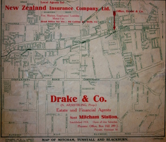
Map - Street Map, R L Jarrett, Map of Mitcham, Tunstall and Blackburn, 1929
Tunstall was originally the name of Nunawading Railway Station. Tunstall opened on 4 June 1888 and was renamed on 1 November 1945. An historically significant advertising map that can be used to ascertain the extent of urban development in 1929 in the areas of Nunawading, Blackburn and Mitcham.A map of Mitcham, Tunstall and Blackburn found on the reverse of a real estate subdivision plan published by R. L. Jarrett of Elizabeth Street. This promotional street map is overprinted with the business address of the sponsors and advertising. Map overlaid in red print: "Drake & Co. / (N. Armstrong, Prop.) / Estate and Financial Agents / next Mitcham Station / Established 1914. Open all day Saturday. / Phones: Office, Box Hill 289 J. / Private, Vermont 10."real estate agents, mitcham, tunstall, blackburn, road maps, drake & co, new zealand insurance co ltd -
 Kew Historical Society Inc
Plan - Subdivision Plan, J R Mathers & McMillan, Myrtle Hill Estate, East Kew, circa 1949, c.1949
... dramatically altered through extensive subdivision and development... and development. The subdivision plan of the ‘Myrtle Hill Estate ...The Kew Historical Society's map collection includes a substantial number of real estate subdivision plans, mainly of Kew but also of surrounding suburbs in Melbourne. Most of the subdivision plans date from the 1920s and 1930s when the districts old homes and local farmland were being split up to accommodate residential growth in the postwar period. These early plans were assembled by a local firm, Jas R Mather & McMillan, which had an office in Cotham Road. Many of the plans, and sometimes photos, were annotated by the agents.Subdivision plans are historically important documents used as evidence for the growth of suburbs in Australia. They frequently provide information about when the land was sold as well as evidence relating to surveyors and real estate and financial agents. The numerous subdivision plans in the Kew Historical Society's collection represent working documents, ranging from the initial sketches made in planning a subdivision to printed plans on which auctioneers or agents listed the prices for which individual lots were sold. In a number of cases, the reverse of a subdivision plan in the collection includes a photograph of a house that was also for sale by the agent. These photographs provide significant heritage information relating house design and decoration, fencing and household gardens.The photograph may also be aesthetically significant depending on the importance of the photographic atelier.Myrtle Hill, at 14 Vista Avenue, Kew, is of local historical and architectural significance as a good example of a large and imposing single-storey Italianate house of the early 1870s surviving in Kew. Originally sited on a large allotment overlooking Normanby Road, the setting of the house has been dramatically altered through extensive subdivision and development. The subdivision plan of the ‘Myrtle Hill Estate’ indicates that in one such subdivision, 11 allotments were created fronting Bowyer Avenue, Myrtle Avenue, and Normanby Road. The outline and building profile of Myrtle Hill is shown on the west side of Bowyer Avenue.The full (typed) title of this subdivision plan is :"Plan of SUBDIVISION of part of CROWN PORTION 83. / at KEW / PARISH OF BOROONDARA. / COUNTY OF BOURKE". / "MYRTLE HILL ESTATE / EAST KEW" In addition to the Title and subtitle, the plan also lists the advantages of the subdivision. -
 Kew Historical Society Inc
Plan - Subdivision Plan, Kew Golf Links Estate, 1936, 1936
The Kew Golf Links Estate was a major subdivision in North Kew. It derived its title due to the land being previously occupied by the Kew Golf Club, which transferred its course to a number of locations before occupying its current site. The Plan advertises 180 choice home sites. The street names are somewhat different today as those on the map are named after the proposed Kodak Factory to be built on the site. The subdivision of the Kew Golf Links Estate was a major subdivision of farmland in Kew. The site was at one stage designated for industrial development and the building of a new Kodak factory. The decision by Council to oppose the redevelopment makes the beginning of the period when all industrial development was banned in Kew.Monochrome printed, folded subdivision plan for the Kew Golf Links Estate, to be auctioned on 7 November 1936. Streets named include: Carnegie Avenue, Willsmere Road, Kilby Boulevarde, Kodak Avenue, Coleman Avenue, Beresford Avenue, McConchie Avenue, Cole Avenue, White Avenue, Baker Avenue, Spruzen Avenue, Tanner Avenue, Ratten Avenue, Mathers Avenue, Railway Avenue, Sutherland Avenue, and Belford Road. The position of the Yarra River and a large Drainage Reserve are marked on the plan. Lots for sale are numbered. Existing buildings are designated with a square.subdivision plans - kew (vic), kodak factory - kew (vic) -
 Kew Historical Society Inc
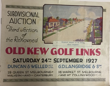
Booklet, Duncan & Weller Pty Ltd, Old Kew Golf Links Estate, 1927, 1927
The booklet advertises the third sale within the Old Golf Links Estate which was a major subdivision of farmland in North Kew in the 1920sThe subdivision of the Kew Golf Links Estate was a major subdivision of farmland in Kew. The site was at one stage designated for industrial development and the building of a new Kodak factory. The decision by Council to oppose the redevelopment makes the beginning of the period when all industrial development was banned in Kew.6 page illustrated brochure advertising the third section of a major subdivision in Kew in 1927 including 75 charming home allotments and 7 valuable building sites. The brochure includes the subdivision plan. The front cover includes a colour illustration of the almost completed houses in Woolcock Avenue. Streets named include: Kilby Road, Kodak Avenue, Baker Avenue, Mathers Avenue, Coleman Avenue, White Avenue and Belford Road. Lots for sale are numbered. Existing buildings are designated with a square.subdivisions - kew (vic), kew golf links estate -
 Kew Historical Society Inc
Book, Plan of General Development, Melbourne : Report of the Metropolitan Town Planning Commission
... Plan of General Development, Melbourne : Report of the... Legislation Part XI Conclusion Plan of General Development, Melbourne ...The 1929 report of the Metropolitan Town Planning Commission covering Melbourne and its suburbs. Includes photographs and 15 folding maps (some in rear pocket) This was a planning scheme to prevent 'misuse' of land and protect property values. It highlighted traffic congestion, the distribution of recreational open space and haphazard intermingling of land uses. The plan identified a number of problems, such as the congestion at St Kilda Junction, that were not addressed until decades later. The plan also recognised the value of Melbourne's waterways as an open space network.xii, 308 p., [25] leaves of plates (24 folded) : ill., maps (some col.), ports., plans ; 34 cm. CONTENTS Part 1 Surveys and studies Part II Communications Part III The execution of improvement schemes - a programme of urgent works Part IV Zoning Part V Public Recreation Part VI Public Utilities Part VII Housing and Land Subdivision Part VIII Civic Art and Amenities Part IX Miscellaneous Part X Legislation Part XI Conclusionnon-fictionThe 1929 report of the Metropolitan Town Planning Commission covering Melbourne and its suburbs. Includes photographs and 15 folding maps (some in rear pocket) This was a planning scheme to prevent 'misuse' of land and protect property values. It highlighted traffic congestion, the distribution of recreational open space and haphazard intermingling of land uses. The plan identified a number of problems, such as the congestion at St Kilda Junction, that were not addressed until decades later. The plan also recognised the value of Melbourne's waterways as an open space network.city planning -- victoria. -- maps, city planning -- victoria -- melbourne, city planning -- victoria, civic improvement -- victoria -- melbourne, melbourne -- (vic.), cartography -
Kew Historical Society Inc
Journal, Kewriosity : September 1992
Opportunity for employers & unemployed young people / p1.Kew Festival and education / p1. Kew's Community Bus / p1. Chief Executive's Column [Influences on rates and charges for 1992/93]; City of Kew Streetscaping Committee / Malcolm Hutchinson p2. Mayor's Comment / Cr Roger Streeton p3. Diary Dates for September/October [1992] / p4. Municipal Health Plan have your say? / p5. Volunteer wanted [Kew Cottges] / p5. Work at home as a family day care giver / p5. Nutrition information win prizes / p6. Holiday fun for children & teenagers / p7. What do women at mid-life want? / p7. Be wise with medicines month / p7. 12 month trials of multi-dwelling development code / p7. Pictures of Kew [Mrs June Stratford, Head of Carey Junior School; Octagonal shelter, Boroondara Cemetery; St Anthony's Home for Children 1922-76; The Hartwell Players] / p8.Kewriosity was a local newsletter combining Kew Council and community news. It was published between November 1983 and June 1994, replacing an earlier Kewriosity [broad] Sheet (1979-84). In producing Kewriosity, Council aimed to provide a range of interesting and informative articles covering its deliberations and decision making, together with items of general interest and importance to the Kew community and information not generally available through daily media outlets.non-fictionOpportunity for employers & unemployed young people / p1.Kew Festival and education / p1. Kew's Community Bus / p1. Chief Executive's Column [Influences on rates and charges for 1992/93]; City of Kew Streetscaping Committee / Malcolm Hutchinson p2. Mayor's Comment / Cr Roger Streeton p3. Diary Dates for September/October [1992] / p4. Municipal Health Plan have your say? / p5. Volunteer wanted [Kew Cottges] / p5. Work at home as a family day care giver / p5. Nutrition information win prizes / p6. Holiday fun for children & teenagers / p7. What do women at mid-life want? / p7. Be wise with medicines month / p7. 12 month trials of multi-dwelling development code / p7. Pictures of Kew [Mrs June Stratford, Head of Carey Junior School; Octagonal shelter, Boroondara Cemetery; St Anthony's Home for Children 1922-76; The Hartwell Players] / p8. publications -- city of kew (vic.), kewriosity, council newsletters, community newsletters -
Kew Historical Society Inc
Journal, Kewriosity : April 1990
Rates reminder / p1. The greening of Kew / p1. Dates for April / p2. Dog fees due / p2. Streetscaping plan / p3. Commentary / Cr Michael Montalto / p3 Residential policies review / p3 . Community bus / p3. High Street parking changes / p3. [Easter] Holiday Program / p4. Library corner / p4. Notices [Anniversary fete] / p4. The view from the dome [Sacred Heart Church] / p4. Car control course for young drivers / p4. Singles talk / p4. Anzac Day / p5. Office [development] Policy launched / p5. Federal Minister in firing line [Family Day Care programs] / p5. Possums playgroup / p5. World focus on literacy this year / p6. Credit card debt a nightmare / p6. Garden weddings fee [Alexandra Gardens] / p6. Siena [College] is 50 / p6. Painting for Kew Library [Studley Park Conservation Society, Louise Folleta - 'Yarra River at Studley Park'] / p7. One year on for women's club [Kew Ladies Probus Club] / p7. In Brief / p7. Council strengthens YMCA links [Kew Recreation Centre] / p7. Neighbourhood Watch / p8. Traffic Management update / p8. Consumer matters / p8. Back care seminar / p8. Introducing the "Fact Pack" [Youth Services] / p8.Kewriosity was a local newsletter combining Kew Council and community news. It was published between November 1983 and June 1994, replacing an earlier Kewriosity [broad] Sheet (1979-84). In producing Kewriosity, Council aimed to provide a range of interesting and informative articles covering its deliberations and decision making, together with items of general interest and importance to the Kew community and information not generally available through daily media outlets.non-fictionRates reminder / p1. The greening of Kew / p1. Dates for April / p2. Dog fees due / p2. Streetscaping plan / p3. Commentary / Cr Michael Montalto / p3 Residential policies review / p3 . Community bus / p3. High Street parking changes / p3. [Easter] Holiday Program / p4. Library corner / p4. Notices [Anniversary fete] / p4. The view from the dome [Sacred Heart Church] / p4. Car control course for young drivers / p4. Singles talk / p4. Anzac Day / p5. Office [development] Policy launched / p5. Federal Minister in firing line [Family Day Care programs] / p5. Possums playgroup / p5. World focus on literacy this year / p6. Credit card debt a nightmare / p6. Garden weddings fee [Alexandra Gardens] / p6. Siena [College] is 50 / p6. Painting for Kew Library [Studley Park Conservation Society, Louise Folleta - 'Yarra River at Studley Park'] / p7. One year on for women's club [Kew Ladies Probus Club] / p7. In Brief / p7. Council strengthens YMCA links [Kew Recreation Centre] / p7. Neighbourhood Watch / p8. Traffic Management update / p8. Consumer matters / p8. Back care seminar / p8. Introducing the "Fact Pack" [Youth Services] / p8. publications -- city of kew (vic.), kewriosity, council newsletters, community newsletters -
Kew Historical Society Inc
Journal, Kewriosity : November 1989
... Grants / 1. Stop Press [Community Services Department, Planning ...Paper collections / p1. Community Assistance Grants / 1. Stop Press [Community Services Department, Planning and Development Department] / p1. Dates for November / p2. Residential policies review / p2. Cotham/Glenferrie traffic plans / p2. Christmas cards / p2. And more Christmas cards / p2. History tapestry nears completion [bicentennial project, Kew Historical Society] / p2. Commentary / Cr Michael Montalto [Council finances] / p3. Municipal Offices temporarily relocate [asbestos] / p3. Osteoporosis apparatus installed at St George's [Hospital] / p4. Camberwell joins holiday program [Teenage Holiday Program] / p3. Notices / p4. Early parenting / p4. Roadworks for Kew / p4. Where are you Clark Kent? [Interchange Inner East] / p5. Bushwalkers clean up [Studley Park] / p5. [St George's] Hospital signs first health agreement / p5. [Royal Women's] Hospital honours work of Kew women / p6. Council waste disposal costs up 30% / p6. Merri Yarra [Municipal Protection] Committee disbands / p6. Keeping you informed [Citizens' Advice Bureaux] / p7. Overdevelopment review put on hold / p7. Kew's Parks - Is there room for improvement / p7. [Woodlands Avenue] Playgroup enrolments open / p7. Neighbourhood Watch / p8. Bowls at East Kew [Kew East Bowling Club] / p8. [Kew Bowling Club] / p8. Kew brothers rowed for gold [Bradley Kinninmonth, Eugene Kinninmonth] / p8.Kewriosity was a local newsletter combining Kew Council and community news. It was published between November 1983 and June 1994, replacing an earlier Kewriosity [broad] Sheet (1979-84). In producing Kewriosity, Council aimed to provide a range of interesting and informative articles covering its deliberations and decision making, together with items of general interest and importance to the Kew community and information not generally available through daily media outlets.non-fictionPaper collections / p1. Community Assistance Grants / 1. Stop Press [Community Services Department, Planning and Development Department] / p1. Dates for November / p2. Residential policies review / p2. Cotham/Glenferrie traffic plans / p2. Christmas cards / p2. And more Christmas cards / p2. History tapestry nears completion [bicentennial project, Kew Historical Society] / p2. Commentary / Cr Michael Montalto [Council finances] / p3. Municipal Offices temporarily relocate [asbestos] / p3. Osteoporosis apparatus installed at St George's [Hospital] / p4. Camberwell joins holiday program [Teenage Holiday Program] / p3. Notices / p4. Early parenting / p4. Roadworks for Kew / p4. Where are you Clark Kent? [Interchange Inner East] / p5. Bushwalkers clean up [Studley Park] / p5. [St George's] Hospital signs first health agreement / p5. [Royal Women's] Hospital honours work of Kew women / p6. Council waste disposal costs up 30% / p6. Merri Yarra [Municipal Protection] Committee disbands / p6. Keeping you informed [Citizens' Advice Bureaux] / p7. Overdevelopment review put on hold / p7. Kew's Parks - Is there room for improvement / p7. [Woodlands Avenue] Playgroup enrolments open / p7. Neighbourhood Watch / p8. Bowls at East Kew [Kew East Bowling Club] / p8. [Kew Bowling Club] / p8. Kew brothers rowed for gold [Bradley Kinninmonth, Eugene Kinninmonth] / p8. publications -- city of kew (vic.), kewriosity, council newsletters, community newsletters -
Kew Historical Society Inc
Journal, Kew Historical Society, Newsletter No.105, December 2013
Development in Studley Ward / Robert Baker p1-2. Society Activities: Exhibitions [Kew Living 25 years on; Kew High School]; Past meetings; Future meetings; McIntyre Lecture / p3. Wilton [Kew RSL] / Don Garden p4-5. Did you know? [Dickens Village; Jellis' Bakeries; Images of Kew / p5. President's 54th Annual Report 2012-13 / Alex Wilson OAM p6-7. Vale [Ray Boothroyd; Beth Brodribb OBE; Robert (Bob) Johnson] / Judith Vimpani p7. Subdivision plans / Robert Baker p8. The Kew Flyer / Tony Michael & Robert Baker p9-10. It happened in the past [50-years ago; 100-years ago] / p11. Support Kew's History / p11. Tara Hall / p12. Book sale / p12.Published quarterly since 1977, the newsletters of the Kew Historical Society contain significant research by members exploring relevant aspects of the Victorian and Australian Framework of Historical Themes. Frequently, articles on people, places and artefacts are the only source of information about an aspect of Kew, and Melbourne’s history.non-fictionDevelopment in Studley Ward / Robert Baker p1-2. Society Activities: Exhibitions [Kew Living 25 years on; Kew High School]; Past meetings; Future meetings; McIntyre Lecture / p3. Wilton [Kew RSL] / Don Garden p4-5. Did you know? [Dickens Village; Jellis' Bakeries; Images of Kew / p5. President's 54th Annual Report 2012-13 / Alex Wilson OAM p6-7. Vale [Ray Boothroyd; Beth Brodribb OBE; Robert (Bob) Johnson] / Judith Vimpani p7. Subdivision plans / Robert Baker p8. The Kew Flyer / Tony Michael & Robert Baker p9-10. It happened in the past [50-years ago; 100-years ago] / p11. Support Kew's History / p11. Tara Hall / p12. Book sale / p12. kew historical society (vic.) -- periodicals., kew historical society (vic.) -- newsletters, kew historical society (vic.) -- journals