Showing 2103 items
matching structures
-
 Bendigo Historical Society Inc.
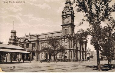
Postcard - TOWN HALL, BENDIGO
black and white photo: image shows Town hall, Bendigo, taken looking southward along Hargreaves Street, approx. 1920's ? Car in centre of image is open top, white wall tyres. Structure on LH side of photo has verandah and appears to be 'open' type of building underneath roofline, Bendigo Market place.To the right of the Town Hall is the north end of a market building, which stood where the Bendigo Library now stands. On rear of card ' printed in Great Britain, The Valentine & Sons Publishing Co., Ltd., Melbourne.'Valentine & Sonsbendigo, buildings, town hall, bendigo, bendigo, town hall, hargreaves street -
 Australian Gliding Museum
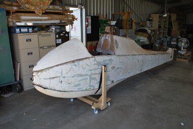
Machine - Glider – Sailplane, 1939
This Dunstable Kestrel glider (which originally was finished in silver paint) was built in 1939 by Ric New and members of the Lake Pinjar Soaring Club. It first flew on 26 December 1939 at Lake Pinjar. The first extensive flight was on 7 January 1940 when Ric New managed to stay aloft for 30 minutes and reach a height of 3000 metres. Unfortunately the Kestrel was badly damaged the same day when another club member Jim Brabazon stalled and spun in. The Kestrel was repaired by June 1940 and flown extensively at Lake Pinjar in 1940 and 1941 until Government authorities intervened and ploughed up Lake Pinjar as a wartime measure to prevent it being used as a landing field by the enemy [Allan Ash, Gliding in Australia, pp 92 – 94]. The Lake Pinjar Soaring club was reformed as the Perth Gliding Club after the end of the war and was joined by Ric New with his Kestrel [Allan Ash, Gliding in Australia, p 103]. The glider was held in storage at the Gliding Club of Western Australia prior to transfer to the Australia Gliding Museum. The Deed of Gift indicates that it was formerly owned by Wally Williams, also from Western Australia. The aircraft is in poor condition and has some non-original elements. It is one of three that currently exist. Nevertheless it is considered to be an important exhibit for relating the history of gliding in Western Australia.Aircraft of wood structure skinned with plywood and fabric – off-white colour scheme – crazed flaking paint on fuselage – nose of fuselage has been modified by addition of streamlining – damage includes impact holes to plywood, especially on starboard side – wings have been stripped of fabric covering and some ribs are missing – tailplane and rudder are in reasonable condition although, like wings, have been stripped of fabric. Overall, while the main elements of this aircraft are present, there are a number of missing fittings and will require extensive works to restore to a static display standard.australian gliding, glider, sailplane, dunstable, kestrel, bill manuel, ric new, lake pinjar soaring club, lake pinjar, gliding club of western australia -
 Bendigo Historical Society Inc.
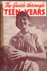
Book - AILEEN AND JOHN ELLISON COLLECTION: BOOKLET - THE GUIDE THROUGH TEEN YEARS
Small booklet (36 pages) "The guide through teen years". Published by Father and son welfare movement of Australia. Fifth edition November, 1957. Contents - Foreword. Introduction. Part 1; Your body. Chapter 1: its structure. Chapter 2: menstruation. Chapter 3: the miracle of human birth. Part 2; Your maturing mind. Chapter 1: your changing outlook. Chapter 2: independence and sex. Chapter 3: vocation and religion. Part 3; Your quest. Postscript: some practical helps to young womanhood.books, school, sex education -
 Ballarat Tramway Museum
Document - Report, Ballarat Tramway Museum (BTM), "Ballarat Treasures Register", 25/07/2006 12:00:00 AM
Yields information about the views of the BTM as to the significance of the tramcars and infrastructure in Ballarat for submission to the City of Ballarat.Ballarat Tramway Museum's submission dated 25 July 2006, to the City of Ballarat titled "Ballarat Treasures Register". Bound within a black plastic spiral folder with plastic sheets containing the individual sheets. Contains - covering letter to the City of Ballarat Cover sheet and nomination form for: Sturt St - section of tram track and track to the Phoenix Foundry and photographs Horse Tram No. 1 ESCo No. 12 SEC 14 SEC 18 SEC 26 SEC 27 SEC 38 SEC 40 Wendouree Parade - track and overhead structuretrams, tramways, ballarat treasures, btm, wendouree parade, tramcars -
 Kew Historical Society Inc
Photograph - Zig-Zag Bridge on the Yarra River at Kew, 1924
Henry Beater Christian (1886-1962) , was a descendant of one of the earliest settler families in Kew. Employed at the Kew Asylum as a 'public servant', he was a skilled amateur photographer, photographing numerous scenes in Kew and on his travels around Victoria. The majority of his photographs date from 1916 to 1929. His finest photographs are housed in two photograph albums. Digital copy of a photograph from page 8 of the 47-page photograph album containing 261 gelatinous silver images, loaned by Diane Washfold with permission given to digitise and hold a copy in our collection. The Zig-Zag Bridge linked the grounds of the Yarra Bend and Kew Asylums. The wooden bridge was constructed in the 1870s and lasted through numerous floods until its destruction in 1929. A horizontal structure, the walkway was reached via a wooden staircase on the Kew side. The steps were required due to the different levels of the banks on this stretch of the river. "Zig-Zag Bridge"henry beater christian (1886-1962), landscape photography, kew (vic.) — yarra river, christian-washfold collection, photograph albums, zig-zag bridge -
 Kew Historical Society Inc
Map, MMBW, MMBW Town of Kew, 1910-21
The Melbourne and Metropolitan Board of Works (MMBW) was established by an act of the Victorian Parliament in 1890 to prepare for and to implement a sewerage and water reticulation system across what was then inner Melbourne, its surrounding and middle distance suburbs, including Kew. The MMBW was disbanded in 1991.The map collection of the Kew Historical Society has at its core the historic maps assembled and originally stored in the City Engineer's Department of the City of Kew. These include maps in a number of scales. The vast majority of maps were produced by the MMBW in the first two decades of the twentieth century, and are solid working maps, backed by linen for durability. These maps are historically significant to Kew, the City of Boroondara and to the history of the development of state utilities in Victoria. A number of the Kew maps have additional details added by former municipal officers, including the levels reached by various floods. As these were working documents, information was added to them long after the period of their initial production and distribution.Early map of the Town of Kew, created after 1910, at a scale 440 ft to 1 inch. The 'assembled' map by the City of Kew Engineer's Department includes scaled down copies of The Melbourne and Metropolitan Board of Works maps, Nos. 39, 40, 64, 65, 66, 67, 68, and 117. The map covers the entirety of the Town of Kew, bordered on its north and west by the River Yarra, by Burke Road in the East and Barkers Road in the south. The map shows the extent of urban development by that time, prominent institutions and the outlines of built structures in the municipality. TOWN OF KEW / SCALE 400 FEET TO 1 INCHmelbourne & metropolitan board of works, mmbw maps, mmbw plans, town of kew, cartography -
 Kew Historical Society Inc
Map, MMBW, MMBW Plan No.40 Collingwood & Kew, 1900-1910
The Melbourne and Metropolitan Board of Works (MMBW) was established by an act of the Victorian Parliament in 1890 to prepare for and to implement a sewerage and water reticulation system across what was then inner Melbourne, its surrounding and middle distance suburbs, including Kew. The MMBW was disbanded in 1991.The map collection of the Kew Historical Society has at its core the historic maps assembled and originally stored in the City Engineer's Department of the City of Kew. These include maps in a number of scales. The vast majority of maps were produced by the MMBW in the first two decades of the twentieth century, and are solid working maps, backed by linen for durability. These maps are historically significant to Kew, the City of Boroondara and to the history of the development of state utilities in Victoria. A number of the Kew maps have additional details added by former municipal officers, including the levels reached by various floods. As these were working documents, information was added to them long after the period of their initial production and distribution.Early map of part of the Borough of Kew, created in the first decade of the twentieth century, at a scale 160 ft to 1 inch. The map covers what was then the south western section of Kew, bordered on its north by Studley Park Road, in the west by Walmer Street and the River Yarra, by High Street South and Princess Street in the East and Barkers Road in the south. The map shows the extent of urban development by that time, prominent institutions and the outlines of built structures in the municipality. Contour lines and historic flood levels were added in ink to the map at a later stage.MELBOURNE AND METROPOLITAN BOARD OF WORKS / PLAN NO. 40 / COLLINGWOOD & KEWmelbourne & metropolitan board of works, mmbw maps, mmbw plans, borough of kew, cartography -
 Brighton Historical Society
Headwear - Hat, Headdress, Late 1800s
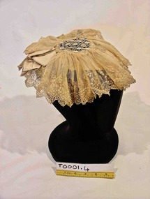
A lace head dress belonging to the women of the family of George Ward Cole’s in the late 1800s. George Ward Cole was an early member of the Victorian Parliament and the family featured prominently in Melbourne Society in their time. They established a substantial home known as “St Ninians” at 10 Miller Street in 1841. The family reportedly entertained Melbourne’s first Royal visitor the Duke Of Edinburgh, Queen Victoria’s second son, at St Ninians in 1867. In later years St Ninians was subsequently subdivided and later demolished. A hand sewn cream lace cap from late 1800s. A silk satin ribbon that encircles the back of the crown of the head, creates the structure of this cap. Towards the front it also has a net and wire-reinforced peak. Over the top of this support is a central diamond shaped lace piece of seven and a half centimeters diameter to which is attached a fine lace net that is gathered and stitched around the edge of the central lace. Two decorative bows of the same silk satin fabric are positioned on the support over the top of the lace at either temple of the wearer. "W-COLE" hand stitched on inside of band. It is unknown when and by whom this inscription was made.st ninians, george ward cole, headwear, late 1800s, brighton, margaret morrison ward cole, agnes bruce ward cole, thomas anne ward cole -
 Bacchus Marsh & District Historical Society
Photograph, Cheese Factory Waddell Street Bacchus Marsh 1883
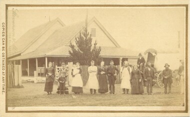
The Cheese Factory in this image was opened around 1879 by Mr. G.G. Pearce. It was in Waddell Street. It was one of the first cheese factories in Victoria. It was later owned and operated by William Telford with the assistance of John Mahon. The factory was described in the Bacchus Marsh Express newspaper as an important business and service for the region. G.G. Pearce was reported to have spent a good deal of money in setting up the factory to ensure it was one which produced high quality cheese using modern methods of production. The factory was sold in 1889 to a Mr. H. W. King who was from Abbotsford in Melbourne. Unfortunately within a few days of Mr King buying the factory it was completely destroyed in a fire. All that was left were two large pine trees and two large underground concrete tanks.G.G. Pearce was described as a pioneer of cheese factories in Victoria. His first factory was just outside of Bacchus Marsh at Hopetoun. Around 1879 he moved into Bacchus Marsh and opened a new purpose built factory in Waddell Street. The Bacchus Marsh Express newspaper reported that no expense had been spared in constructing this factory. The factory was completely destroyed in a fire in 1889 which makes it fortunate that this image was captured of this early cheese factory in Victoria.Small sepia unframed photograph on card with gold border framing photograph. Housed in the album, 'Photographs of Bacchus Marsh and District in 1883 by Stevenson and McNicoll'. The image shows a group of men and women standing in a row in front of the Bacchus Marsh Cheese factory. One of the women is holding a small child. In front of another woman stands a young boy. Behind them is a covered wagon with a man seated upon it. Some of the men and women are wearing long aprons. In the background is the Cheese Factory. It is a large wooden structure with a high and steep pitched roof.On the front: Stevenson & McNicoll. Photo. 108 Elizabeth St. Melbourne. COPIES CAN BE OBTAINED AT ANY TIME. On the back: LIGHT & TRUTH inscribed on a banner surmounted by a representation of the rising sun. Copies of this Portrait can be had at any time by sending the Name and Post Office Money Order or Stamps for the amount of order to STEVENSON & McNICOLL LATE BENSON & STEVENSON, Photographers. 108 Elizabeth Street, MELBOURNE stevenson and mcnicoll 1883 photographs of bacchus marsh and district, cheese factories, bacchus marsh cheese factory -
 Bacchus Marsh & District Historical Society
Photograph, Simpsons Butchery Main Street Bacchus Marsh 1883
John Simpson arrived in Bacchus Marsh around 1848. In 1850 he established a butchery business. He continued to operate this business in Main Street Bacchus Marsh until his death in 1890. His son John Simpson and one of his brothers, Edward took over the business and operated it until 1923. John Simpson the younger died in 1940 having lived all but a few months of his 92 years in Main Street Bacchus Marsh. Edward L. Simpson died in Corowa, NSW in 1937. The younger John Simpson's recollections of Bacchus Marsh in the 1850s to 1870s were published in the Bacchus Marsh Express on the 25 June 1932.Small sepia unframed photograph on card with gold border framing photograph. Housed in the album, 'Photographs of Bacchus Marsh and District in 1883 by Stevenson and McNicoll'. The image shows a butchery shop in Main Street Bacchus Marsh in 1883. The front of the building is shown. It is a solid brick or stone structure with a shingled roof and verandah. Hanging under the verandah are numerous carcasses and portions of meat. Two men are standing close together in front of the shop. One is wearing a butcher's apron. Another man to the left sits upon a horse. In the doorway behind the men stands a woman. On the front: Stevenson & McNicoll. Photo. 108 Elizabeth St. Melbourne. COPIES CAN BE OBTAINED AT ANY TIME. On the back: LIGHT & TRUTH inscribed on a banner surmounted by a representation of the rising sun. Copies of this Portrait can be had at any time by sending the Name and Post Office Money Order or Stamps for the amount of order to STEVENSON & McNICOLL LATE BENSON & STEVENSON, Photographers. 108 Elizabeth Street, MELBOURNE. stevenson and mcnicoll 1883 photographs of bacchus marsh and district, butcher shops, butchers, john simpson butcher 1848-1940, john simpson butcher died 1890 -
 Melbourne Tram Museum
Document, Melbourne & Metropolitan Tramways Board (MMTB), Untitled - "SW6 class", May. 1939
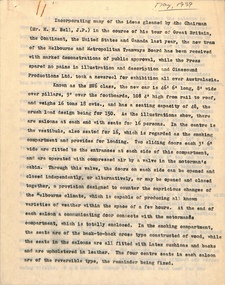
Report - 7 quarto typed sheets - untitled, but gives a detailed description of the design basis and construction of the SW6 class tram. Dated May 1939. Details the design after Bell's overseas trip the previous year. Details dimensions, seating, ventilation, seating, doors, structure, construct, timber, materials, door engines, cab equipment, PA system, interior appearances, flooring, colours, lighting, conductor's bell / signals, trucks, bolster, wheels, brake shoes, braking, motors, acceleration, performance, controllers, contactors, compressor. Gives a detailed list of the specifications.Has a note in pencil about a typographical error on the bottom of the sheet.trams, tramways, sw6 class, specification, tramcars, tram controllers, tram equipment, tramcar design -
 Bacchus Marsh & District Historical Society
Photograph, Symington Brewery, Hopetoun, near Bacchus Marsh 1883
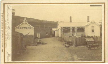
The family of William Symington arrived in Melbourne in 1855. By 1858 they had come to Bacchus Marsh and built a house at Hopetoun a few kilometres east of the town. A brewery next to the house was also built around this time. It was a licensed brewery between 1862 and 1886. The elder William Symington died in March 1867 and the brewery was then operated by his son the younger William Symington for a number of years. It ceased operations sometime before 1900. Small sepia unframed photograph on card with gold border framing photograph. Housed in the album, 'Photographs of Bacchus Marsh and District in 1883 by Stevenson and McNicoll'. The image shows the brewery and house which belonged to the Symington family of Hopetoun, near Bacchus Marsh. The house is a timber structure with two chimneys and a front verandah. The front yard of the house is enclosed by a timber fence. At the front of the fence can be seen a dog kennel. Other tools, such as a wheelbarrow, lie in the yard. The brewery building is of timber and brick. On the hillside behind the buildings are paddocks fenced with post-and -rail fencing.On the front: Stevenson & McNicoll. Photo. 108 Elizabeth St. Melbourne. COPIES CAN BE OBTAINED AT ANY TIME. On the back: LIGHT & TRUTH inscribed on a banner surmounted by a representation of the rising sun. Copies of this Portrait can be had at any time by sending the Name and Post Office Money Order or Stamps for the amount of order to STEVENSON & McNICOLL LATE BENSON & STEVENSON, Photographers. 108 Elizabeth Street, MELBOURNE. stevenson and mcnicoll 1883 photographs of bacchus marsh and district, breweries, symington family bacchus marsh, william symington 1840-1929, william symington 1802-1867 -
 Orbost & District Historical Society
black and white photographs, Howard D. Bulmer, first half 20th century
This bridge was built in the 1920s as a road and rail bridge, and was partly washed away by flood waters in 1934. After the end of the first World War the Victorian Railways considered an extension of the railhead across the river at Orbost, and in 1922 a new timber and steel girder structure, a joint Country Roads Board — Victorian Railways venture, was built and completed at a cost of £41,000 (the steel girders came from the Flinders Street viaduct reconstruction). Subsequently it was decided not to take the railway across the river, and the bridge has only been used by road traffic. This is a pictorial record of an early bridge across the Snowy River at Orbost.A large black / white photograph of the Orbost Snowy River bridge. There is a large copy as well as a postcard copy in sepia.on front - Snowy River Bridge Orbost H.D. Bulmer - photo - Lake Tyers.snowy-river-bridge-orbost -
 Warrnambool and District Historical Society Inc.
Criterion Hotel Glass, Glass, Mid 20th century
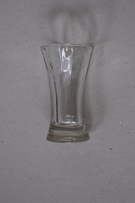
This small glass has been kept as a souvenir of the Warrnambool Criterion Hotel by a local resident, James Godfrey. The Criterion Hotel opened in Kepler Street, Warrnambool in April 1872. The first licensee was John Tate and the Humm family members of Woodford and the McGennan family of Warrnambool were prominent licensees and owners in the late 19th and 20th centuries. In the second half of the 20th century the hotel was an important centre in Warrnambool for live pop music. The hotel closed in 2008. The building was partially destroyed by fire in 2010 and the remaining structure was demolished in 2013. This glass is significant because it has local provenance as a memento of a hotel in Warrnambool prominent in the local business world for 136 years and as an example of the souvenirs kept of this hotel by Warrnambool residents.This is a small clear glass tumbler with a heavy base and a slightly tapered neck and a circular open top. The name ‘Criterion Hotel’ has been etched on to the side of the glass.Criterion Hotelcriterion hotel warrnambool, history of warrnambool, glass -
 Federation University Historical Collection
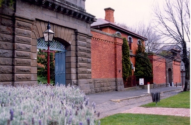
Photograph - Colour photograph, Former Ballarat Gaol Gates, 24/04/2017
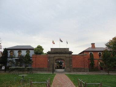
The main gate to the former Gaol is a monumental work. The arch keystone facing Lydiard Street is beautifully executed. The gates and the iron lacework over the top are distinctive.The arch under the flyover is also distinctive; the basalt keystone appears to have been cut from one single block of stone. Most of the gaol has been demolished to allow the School of Mines Ballarat to expand onto the site. The remaining structures at the site include the main gate, warden's residence and governor's residence. These buildings are now used by Federation University.The main gate to the former Gaol is a monumental work. The arch keystone facing Lydiard Street is beautifully executed. The gates and the iron lacework over the top are distinctive.The arch under the flyover is also distinctive; the basalt keystone appears to have been cut from one single block of stone. gate, gaol, arch keystone, lydiard street, iron lacework, flyover, stone, basalt, warden's residence, governor's residence, ballarat school of mines, federation university, former ballarat gaol -
 Kiewa Valley Historical Society
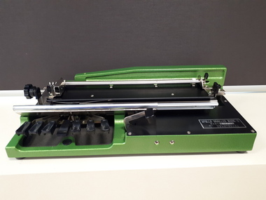
Tape Measure 33ft, Early to mid 1900's
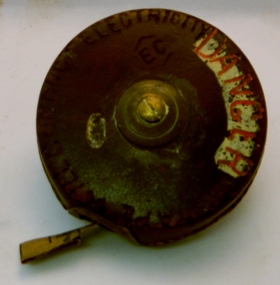
This flexible measuring tape was used by the SEC Victoria in the mid to late 1900's. It was in a period before digital measuring instruments were in use. This is a 33ft long tape measure and would have been used by the construction workers when building the Kiewa Valley Hydro System. The warning details (embossed into the leather covering) was to warn users to be careful not to use the tape near live electricity terminals or linkages. This tape was produced mainly for wooden structures and not electricity conductive material. This was during the 1950's to 1960's.This imperial tape measure is very significant to the Kiewa Valley as it was used in the construction of the Kiewa Valley Hydro Scheme of the 1950's-1960's. It provides evidence that small measuring equipment used in the construction and the continuing maintenance of the scheme was of the imperial measure and used by construction workers who remained and settled in the town of Mount Beauty and Kiewa Valley long after the construction period. This flexible metallic measuring tape (33 ft in length) is contained in a round circular leather bound container. It has brass fittings (winder and tape guide) and is stitched with heavy grade twine. The tape measure is graduated in feet and inches on one side and yards on the other. Embossed in the leather casing"MADE IN ENGLAND" and around the inner circle "HOCKLEY ABBEY" and "JOHN RABONE & SONS"imperial tape measure, distance measures, imperial tools -
 Eltham District Historical Society Inc
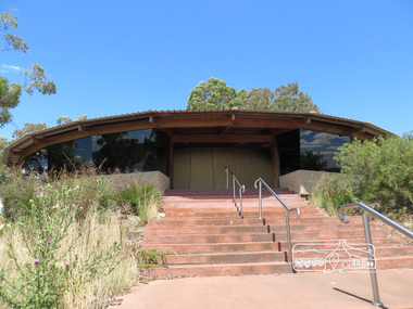
Photograph, Sugarloaf Reservoir, Christmas Hills, 16 January 2015, 16 January 2015
Structure at Sugarloaf. Sugarloaf Reservoir is situated on former farmland. This large water storage was completed in 1982 and serves Melbourne's northern suburbs. Within the visitor areas are two picnic grounds and other recreational facilities. Below its massive rock embankment is located the Winnecke Treatment Plan designed to purify its water before being piped into Melbourne. The dam partly inundated the old firing ranges of the former Christmas Hills Rifle Club. Source: Christmas Hills Now and then: Yarra Glen & District Historical Society, 2004. Born Digitalchristmas hills, sugarloaf reservoir -
 Federation University Historical Collection
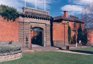
Photograph - Photograph - Colour, Former Ballarat Gaol Gates and Warden's Quarters, 2001, 1991
The Ballarat Gaol operated between 1862 and 1965. The complex was based on a central hall from which radiated wings of cells. This meant one guard could stand in the centre of the hall and see all the cells. Most of the gaol was demolished to allow the School of MInes Ballarat to expand. The remaining structures at the site include the main gate, the Warden's Residence, shown in the photo, and the Governor's Residence. These buildings are now used by Federation University. The Warden's Residence is home to the Australian Centre for Research into Injury in Sports and its Prevention.Colour photograph of the main gate of the former Ballarat Gaol and the Warden's Quarters. The gate features a beautifully executed arch keystone of basalt and appears to be cut from one single block of stone. The two storey Warden's Quarters are to the right of the gates.ballarat gaol, lydiard street south, ballarat school of mines, cells, guard, warden's residence, governor's residence, federation university -
 Federation University Historical Collection
Colour photograph, Ballarat Courier Photographer, Former Ballarat Gaol Gates, 09-06-1997
The main gate to the former Gaol is a monumental work. The arch keystone facing Lydiard Street is beautifully executed. The gates and the iron lacework over the top are distinctive.The arch under the flyover is also distinctive; the basalt keystone appears to have been cut from one single block of stone. Most of the gaol has been demolished to allow the School of Mines Ballarat to expand onto the site. The remaining structures at the site include the main gate, warden's residence and governor's residence. These buildings are now used by Federation University.The main gate to the former Gaol is a monumental work. The arch keystone facing Lydiard Street is beautifully executed. The gates and the iron lacework over the top are distinctive.The arch under the flyover is also distinctive; the basalt keystone appears to have been cut from one single block of stone. gate, gaol, arch keystone, lydiard street, iron lacework, flyover, stone, basalt, ballarat school of minesfederation university, warden's residence, governor's residence -
 Bendigo Historical Society Inc.
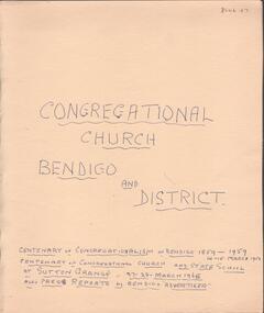
Document - Lydia Chancellor collection: congregational church Bendigo and district
The Sutton grange Congregational Church was built in 1865. Original services were held in the home of Mr James Grey who served the church for 50 years. The Bendigo Congregational church originally operated out of the Mechanics Institue building before moving temporarily to the Church of England school room. In May 1858, a meeting was held to establish a permanent building and tenders were called in September 1858. Land was purchased in Forest Street from the estate of Mr WIlkinson and the new brick structure was opened 28/11/1858.Manilla folder titled: Congregational Church Bendigo and district. Centenary of congregationalism in Bendigo 1859 to 1959, 14-15 March 1959. Centenary of congregational church and state school at Sutton Grange, 27-28 March 1965. Also, press reports in the Bendigo Advertiser.sutton grange, congregational church, centenary -
 RMIT Design Archives
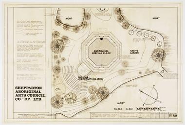
Work on paper - Architectural drawings, Aboriginal Keeping Place, Shepparton International Village
Site plan drawing of the Shepparton Aboriginal Arts Council building, now known as the Bangerang Cultural Centre. The building is located in the Parkside Gardens, formerly the Shepparton International Village, and is the first Aboriginal cultural museum developed and managed by the Aboriginal community. The building is part of the Victorian Heritage Register. Romberg designed the building in conjunction with project instigator and Bangerang Elder, John Sandy Atkinson, OAM. At the request of Romberg, Atkinson created some concept sketches for the building from which Romberg designed the finished structure.Site PlanInitialed in grey pencil, bottom right: 'F.R'architecture, museum -
 Melbourne Legacy
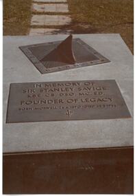
Photograph - Photo, Stan Savige Memorial
Three photos of a memorial to Stan Savige in Morewell Victoria. The concrete structure has a sundial and a plaque. The inscription on the plaque says: "In memory of Sir Stanley Savige / KBE, CB, DSO, MC, ED. / Founder of Legacy / Born Morwell 26.6.1890 - Died 15.5.1954" Photos came from an envelope marked P1 Federal Conference 1973 / 50 Year anniversary / 1983 Morewell / 1973 Legacy March ANZAC Day, 50 yr celebration, inclusion in ANZAC Day March authority of RSL". See items 00452, 00391A record of a memorial to Stan Savige in his birthplace of Morwell.Colour photo x 3 of the Stan Savige memorial in Morwell.stan savige, memorial, morwell, sundials -
 Melbourne Legacy
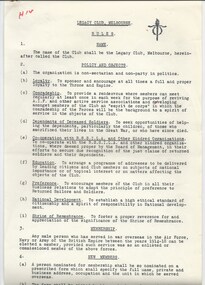
Document - Document, rules and objects, Legacy Club, Melbourne. RULES / POLICY AND OBJECTS (H14)
A document detailing rules and regulations of the running of the Legacy Club, Melbourne. The date is not known. The policy and objects covers: loyalty, comradeship, dependents of deceased soldiers, cooperation with other organisations, education, preference, national development, and Shrine of Remembrance. Other parts of the document covers eligibility for membership, transfer of members, subscriptions etc. Meetings and their procedures as well as management structure. It is possibly before 1940 when the RSSILA changed it's name to RSSAILA. The notation H14 in red pen shows that it was part of the archive project that was trying to capture the history of Legacy. Documents the details of the rules and policies of the Legacy Club, Melbourne.White foolscap paper with black type x 7 pages of a document of regulations.Handwritten H14 in red pen. history, rules, organisation structure, objectives, goals -
 Vision Australia
Equipment - Object, Apollo Brailler Mark II, 1979-2005
Designed by Nimoka (Nippon Moujin Youga Kaihatsu), it was produced between 1979-2005. A heavy Braille writer for its size, the Apollo provides a standard typewriter style albeit with the oblong keys sitting to the left hand side of the brailler. The design easily fits within a small musical instrument style case, and consists of a rectangular shaped structure made out of metal base with black coloured keys and a grey coloured soft plastic cover. Underneath a battery compartment (which powers a bell) is kept closed with a capped screw.Black and green metal object with covering boxApollo Brailler Mark-II (Serial number) 834400braille equipment, assistive devices -
 Kiewa Valley Historical Society
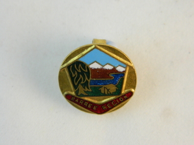
Badge Girl Guides, circa mid to late 1900's
This commemorative badge identifying the wearer as a Girl Guide and was used in the 1970's and later. The Girl Guides "World Camps" was founded in 1924 and each subsequent "camp" was in other global countries. The Camp Baree was held in 1947/1948 in Pennsylvania in the USA. In Victoria, Australia, a Barree Regional location for Girl guides, encompasses the Kiewa Valley and its regions. Girl guides in rural areas covered the same developmental programs as in the city areas but the bush settings of annual camps did not have the same impact as for city based guides. The comradeship however, bringing together girls from a widely diverse background, was still a very important objective of the Girl Guide movementThe significance of this badge is that the Girl Guides held a World Camp in the Barree region which included the Kiewa Valley.This world wide attention(Girl Guides) to this region paid special attention to the "home side" girls and highlighted in particular those girls in the Kiewa Valley who participated in the Girl Guide movement. The ability to have such a personal contact with so many girls from so many world regions helped to break the somewhat isolated regional life. The fundamental lessons of the girl guides was and still is to enrich young girls knowledge of skills which provides self esteem, pride in achievements and the togetherness with like minded girls. Social barriers are left behind and good friendships are formed. Some of these friendships continued as life long links.This round badge made from brass and has coloured enamel sections outlining various "Barree Region" scenery. In the far distant horizon are snow capped mountains. These are coloured brown with white tipped summits.The central focus is a blue stream with a dark blue "gum" tree to the left and a brass etched tent pegged onto green grass. These pictures are framed within a house structure. A red coloured boomerang lies under the "house" frame with the name of the region on it,"BARREE REGION" The badge is fastened onto a lapel or other clothing by two "L" shaped hooks extending from the back of the badge.On the front of the badge (on the sketched boomerang "BARREE REGION". On the back in raised lettering is"BERTRAM BROS MELB."societies, girl guides, barree region, metal identity badges -
 Bendigo Historical Society Inc.
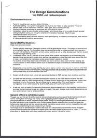
Document - Digital, BENDIGO JAIL DEVELOPMENT
Photocopy undated article from Australian Conservation Foundation re Bendigo Jail, together with undated Design Considerations for development of BSSC jail redevelopment. 1. Article by Brian Morley outlines history of the jail, Ronald Ryan's execution in 1967, and petitions against capital punishment. 2. Three page stapled A4 sheets, undated unknown authority document titled 'The Design Considerations for BSSC Jail redevelopment'. Outlines environment, class room structure models, general office & exhibition space, lecture theatre, overall buildings, design consistency, and learning area requirements.bendigo, institutions, bendigo jail -
 Port Melbourne Historical & Preservation Society
Photograph - Domestic and business structures, Port Melbourne, Ron Laing, 1986 - 1999
Part of Ron Laing's collection of photographs recording Port Melbourne over a thirteen year period. Donated to the PMH&PS by the photographer.A set of colour photographs of Port Melbourne domestic and business structures, c1999, including new house at 31 Ross, former Masonic Hall at 18 Stokes St (1858), New houses on old J&R Garage site, Graham and Clarke St, new housing project on Walsh Transport Depot in Albert Street, building cnr Stokes and Graham, house cnr Graham and Albert, west side; only surviving milk bar within a radius of 100m from cnr Graham and Albert; ex-butcher shop/ex-chicken shop, 400 Graham Streetbuilt environment - domestic, built environment - commercial, business and traders, ron laing -
 Bendigo Historical Society Inc.
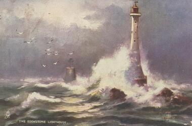
Postcard - GLADYS DEAN COLLECTION: POSTCARD, 1906 - 1908
Printed coloured postcard. Image is of The Eddystone Lighthouse and depicts a lighthouse on rocks with a smaller brick structure nearby in stormy seas and gulls in the sky. The words The Eddystone Lighthouse with a small symbol in white appear along the bottom left hand edge. Reverse is addressed to Miss Dean 'Esmond' Golden Square Bendigo and has a one penny stamp affixed postmarked Kerang. The words Raphael Tuck and Sons "Oilette" (Regd) postcard 7062 "Rough Seas" Art Publishers to Their Majesties the King and Queen after the black and white originals by Elmer Keene are printed in red along the left hand edge.Raphael Tuck and Sons 'Oilette' Regd Postcard 7062 'Rough Seas'postcard -
 Bendigo Historical Society Inc.
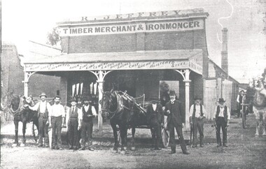
Photograph - HARRY BIGGS COLLECTION: R JEFFERY TIMBER MERCHANT & IRONMONGER
Photograph. Harry Biggs Collection. 2 black & white photos (1 smaller) of 8 men with horses & drays standing in front of the R Jeffery Store. At the back of this group can be seen 3 people under the verandah. At the side is another man & also a horse & dray. On the verandah structure are the words - Bar, Hoop, sheets galvanised iron, zinc, lime cement, laths, doors, sashes, cast shear Blistered Steel. At the side of the verandah are the words Timber & Iron Yard. Plate 126 Premises of Jeffery Bros, Victoria Street, Eaglehawk. (Robinson Photo). 1 photocopy of these photos.Robinson Photoplace, building, commercial, harry biggs collection, r jeffery timber merchant & ironmonger, eaglehawk -
 Kew Historical Society Inc
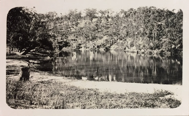
Photograph - Zig-Zag Bridge, 1924
Henry Beater Christian (1886-1962) , was a descendant of one of the earliest settler families in Kew. Employed at the Kew Asylum as a 'public servant', he was a skilled amateur photographer, photographing numerous scenes in Kew and on his travels around Victoria. The majority of his photographs date from 1916 to 1929. His finest photographs are housed in two photograph albums. Digital copy of a photograph from page 8 of the 47-page photograph album containing 261 gelatinous silver images, loaned by Diane Washfold with permission given to digitise and hold a copy in our collection. The Zig-Zag Bridge linked the grounds of the Yarra Bend and Kew Asylums. The wooden bridge was constructed in the 1870s and lasted through numerous floods until its destruction in 1929. A horizontal structure, the walkway was reached via a wooden staircase. The steps were requires due to the different levels of the banks on this stretch of the river. The photo is taken from the Kew side of the river. "Zig-Zag Bridge"henry beater christian (1886-1962), landscape photography, kew (vic.) — yarra river, christian-washfold collection, photograph albums, zig-zag bridge