Showing 1033 items matching "the board of land "
-
 Canterbury History Group
Document - School Project: Elgar's Special Survey, Tudehope, Jennifer, 1963
Well researched essay on the background of Elgar's Special Survey. Includes mapcanterbury, elgar> henry t., land surveys, boroondara, campbell> j & r, dacre> r, towns> r., sea> h., dyce> a., mccarthy> w.g., shenley> james, henty's paddock, norris> j.r., maling> j, canterbury road, survey road, boroondara roads board, camberwell historical society, mont albert road, brooks> r., land subdivisions -
 City of Greater Geelong
Paper on Board, Framed Land Sale Poster, Ocean Grove
-
 Royal District Nursing Service (now known as Bolton Clarke)
Photograph - Photograph, black and white, Barry Sutton, 05.02.1970
This sign was displayed at the 1st International Domiciliary Nursing Congress which was hosted by the Royal District Nursing Service (RDNS).The 1st International Domiciliary Nursing Congress was hosted by Royal District Nursing Service (RDNS). Mrs. D.(Elsa) Hallenstein, President of RDNS, presided over the opening ceremony with the Prime Minister of Australia, the Hon John Gorton opening the Congress. It was held in Melbourne and ran from the 1st to the 8th of February 1970. Many delegates came from around Australia and overseas; from the World Health Organisation; from the North American continent; from Europe, from Asia and from the Pacific. Black and white photograph showing the sign displayed at the 1st International Domiciliary Nursing Congress. Across the photograph is a long black metal stand, with eight legs, which holds a large board. On the upper quarter can be seen to the left a medium sized black circle which has the lettering '1st' outlined in white on it. To the right of this is the black lettering "International Domiciliary Nursing Congress" in capital letters on a white background. Below the black circle, on a white background, is a large round white globe outlined in black and with black spaced vertical and horizontal grids on it. In the lower centre of this is the black coloured land mass of Australia. Over the left hand top section, and above and to each side of the white globe are different land masses of the world displayed in grey. To the right of this there are two grey sections which are divided vertically with a black line,.and contain information on white sheets. To the right of that is a white section with round photographs in three pairs running down the board.Photographer stamp. Quote No. JE 4royal district nursing service, rdns, mrs d. (elsa) hallenstein, hon john gorton, 1st international domiciliary nursing congress -
 Melton City Libraries
Map, Streets of Melton, 1963
MELTON’S STREETS Heritage Week 2014 What’s in a Name? Alphabetical List Aboriginal place names, Early Family Names and landowners, Agricultural, Shop and Commercial premises, Places and Events Melton & District Historical Society Street Naming Project 1972 – c 1998 Suburb Name – KURUNJANG - Kirkton, 1972, Brookfield, West, 1988 Melton and Town Centre - A joint collaboration with the Shire of Melton and Subdivision Developers ARNOLD Court – Family house - Arnolds Creek ALKEMADE Drive Family – Lime kilns Coimadia ALEXANDRA Street 1902 – Corination of King Edward VII and Queen Alexandra AVIATOR Place Event, location of plane crash – Jimmy Melrose 1936 Adina ?Annibee - Anniba? Agricultural Avon court .. .. BAKERY Square - Location of Jongebloed shop, bakehouse and stables BALUK Place Aboriginal BARLEYCORN Place Agricultural BILLING Place Name of Jimmy Melrose Uncle Noel Pemberton Billing BLACKWOOD Drive - Alexander Blackwood 1860c Registrar BARRIES Road C. E. Barrie “Darlingsford” farmer 1911, chaff mill owner BROOKLYN Road Staughton family residence. 1875 – Dismantled c 193? CAHILL Drive Family - Glenville Dairy CAMERON Court Family Canopus Place ? CANALLAN Drive Early Surveyor CAMPBELL Court Aviation – Melrose passenger 6th July 1936 CARBERRY Drive Michael, early landowner family CAREW Court Edward and Michael. Royal Hotel. Vera (Carew) Forran Singer - Opera CASEY Court Family CASHIN Court Family CHEVIOT Court Agriculture, breed of sheep CHESNEY Road was re named ( Minns Road being duplicated c 1973) CHRISTINA Crescent Christina McPherson, daughter of James and Mary Mary McPherson. Died 1955 aged 85 years COLLYER Close a deleted street (parallel to Yuille) re-used CORRIEDALE Road Breed of sheep CORR Court Teacher at first school, landowner CROXTON Court Name of the Hornbuckle and Knox family home DALEY Court - William Daley and family 1865 Bootmaker High Street DARLINGSFORD Boulevard - Name of early homestead Thomas B Darling 1853 DJERRIWARRH Court - Parish County of Bourke - very early map. DODEMAIDE Place Early land owners - Melton Football Team had 6 brothers playing c 1924 DONALD Court McPherson family 6 generations in Melton in 1936 DOUGAL Court DUNCAN Court .. .. DUNVEGAN Circuit Home of the McPherson family, castle Isle of Skye Name of bluestone house Smith Street (now at Willows) EMIL Court Jongebloed family EXELL Avenue Farming family Melton Sth- Closer Settlement 1907 EXFORD Road Exe former name of the Werribee river FARMER Court Name of early postmistress FERRIS Road John Ferris Farmer HANNAH Close First name of Hannah Watts – midwife HAYBALE Place Agricultural HELDER Court Early surveyor J Helder Wedge map HEWSON Street Winston Hewson Shire Engineer – check title c 1960 HENRY Street Township map c 1860 HESTON Street Heston Phoenix – C.J. Melrose plane HILDEGARDE Court Jimmy Melrose’s mothers name HOMESTEAD Close HORNBUCKLE Cres Farmers. Three members of family - Shire Presidents HURLEY Street Farmers IAIN Court Descendent of James and Mary McPherson JAMES MELROSE Drive Name appears on 2013 Melton information map JANG Place KURUN – jang KIRKTON Drive Name of the McPherson family home Toolern Vale Road KIRWIN Street Michael early landowners (deleted for freeway construction) KILPATRICKS Road Deleted when Barries Road was extended across Station Rd KOROROIT Court Early map, Parish of Kororoit. Creek name KNOX Circuit Family – Hornbuckle “Croxton Park” KURRUNJANG Drive Aboriginal name for people of the red earth – Suburb name Lara Place ? LLOYD Court Garage owners High Street. Laura lived to 100 years D 1955 LUBY Court John Luby – Crown Grant Land Title LITTLE Court MANNING Avenue Richard, hotel owner 1891 MARGARET Drive McPherson family McDONALD Street Melton South family name McKENZIE Street Township c1860 MORROW Street Early name MOWBRAY Crescent Name of English Melton, popularly believed origin of Melton MYERS Court Early setters c 1866 Crown Grant Land Title NIMMO Street Early name NIXON Street Name submitted by Mary nee Nixon Collins c1985 OLDERSHAW Road Early builder PALMERSTON Street Early township map c 1860 PEART Court Early name PENNYROYAL Avenue Plant growing by the creek. Early name used for the Toolern Toolam Creek PINKERTON Street Family name and early street map PINNACLE Crescent Agricultural - type of wheat PHOENIX Circuit C.J. Melrose Phoenix Heston Plane 2013 map PRATT Family PRIOR Court PYKE Place Brothers – early settlement 1838 RADFORD Court Land owners and business operators. Former Royal Hotel Grocer High Street demolished 1970 RAGLAN Court Hotel 19th century Lord Raglan RALEIGHS Road Oliver Reierson family (Norweigen) Shopkeeper – Dressmakers RIDDELL Drive (misspelt Riddle) Resident and land owner RODERICK Road McPherson family – a re occurring name ROLLAND Court Jones family ROSS Court Daniel. Landowner. Agnes Ross music teacher RUSSELL Court Robert. Early land surveyor of Melton 1853 RYAN Court Family early landowner. Member of the 1862 Road Board SHEBLER Place Augustus early Melton resident – Golden Fleece Hotel SHEEPFOLD Court Farming SHERWIN Court Sherwin Street earliest Township map– became Golf course SMITH Street Early township map. STRATHULLOH Circuit Strathtulloh Homestead. STAUGHTON Street Family – LARGE land owners Strachan ? SWANEY Court Marie Swaney earlier resident of Strathtulloh. SUTHERLAND Family name TOOLERN Street TOOLAM – TOOLERN Creek TULLIDGE St Road marked on 1861 map UNITT Street Early Township c 1860 WALLACE Square Cr Jack Wallace 5 terms as President 46 years unopposed WATTS Court Hannah Watts – midwife, cottage hospital WALSINGHAM Name of house of Minns family. From Walsingham Norfolk England WESTLEY Place Name of Jimmy Melrose Percival Gull Plane WESTLAKE Drive Early resident WHICKHAM Street Family Name Melton South WILSON Road Albert, Melton South YUILLE Street William Cross, early landowner, Rockbank run Zoomed in section of Melton Streets including Church and High Streetlandscapes of significance -
 Melton City Libraries
Newspaper, Melton Schools-150 years in Melton, 2005
Melton South "The establishment of a settlement of Melton South was induced by the opening of the railway in 1884. This subsequently prompted a number of industries, initially sawmills, and in the early twentieth century, chaff mills. This development coincided with the Exford ‘Closer Settlement’ estate at the beginning of the new century, boosting local population and produce, and the development of the chaff industry which employed many people in the Melton area. (Around 1912 the government had brought out English migrants to settle the Exford estate.) By c.1912 the small Melton Railway Station settlement had a boarding house (probably for chaff or sawmill employees), store, a small church and a hall. The Melton Valley Golf Club originated near the railway station in 1927 (in 1931 it moved to the present Melton links). In 1910 the community had built the large timber ‘Victoria Hall’, which became the focus of community life for several generations. In August of that same year AR Robertson MP and D McDonald applied for the establishment of a school on land set aside for that purpose by the Closer Settlement Board, near the Melton Railway Station settlement. District Inspector McRae recommended that a school for classes up to Grade 3 be established as an adjunct to the Melton State School. And so SS3717, ‘Melton Railway School’, was established in the leased Victoria Hall on 1st December 1911. Thomas Lang, head master at Melton since 1896, was in charge of both schools. As a ‘prep’ school only, it was necessary that the older Melton Railway Station settlement students travel to Melton SS430 at Unitt Street. Since 1912 local residents had been petitioning for the establishment of a separate school at Melton Railway Station on the grounds that it would be better if all children from the one home could attend the same school, and that the Victoria Hall was unsuitable as a school building. As a result an area of 2 acres - Allotment 8, Parish of Djerriwarrh, Exford Estate - was reserved for a State School on 4th March 1914. However the Department wrote that a school would not be established there in the near future, as ‘there is no likelihood in sight that the Railway Station settlement will increase in importance’. Parents persisted with their petitions to the Education Department, claiming that the Victoria Hall was too large, had no fireplace, that teachers were unable to use the wall for teaching aids, and that, being less than 20 metres away from a chaff mill employing 30 men, was too noisy. The turning point came when in 1920 the Hall Committee decided to increase its rent for the hall. In 1920 Head Teacher Lang advised the Education Department to discontinue SS3717 as an adjunct. The District Inspector supported this recommendation, and the schools separated in 1923. In April of that year 41 children, comprising Grades 1-8, moved into an almost completed brick building on the present site. On the 6th July 1923 the official opening of the school took place; after a ceremonial journey from the Hall to the school, speeches were given by the Hon AR Robertson and the Chief Inspector of Education. Everyone then journeyed back to Victoria Hall for a ‘bountiful repast’. (These dates are at odds with the date of 5th March 1925 given in Blake as the date the children occupied the new SS3717 brick school building. ) A teacher’s residence had been purchased for ₤500 in 1923, and the school’s name was changed to ‘Melton South’ in the same year. Even though the older Melton South pupils would no longer have to travel to the Unitt Street school, an additional brick room was still required at the Melton SS430 in that same year. In 1961 a new room was added to the school. In 1972, at the beginning of Melton’s boom as a satellite town, the number of enrolments was 224. The school has since shared in the exponential growth of the town of Melton, and at the time of its jubilee celebration (1983), 524 pupils were enrolled. Victoria Hall, neglected and vandalised, was demolished in 1992. It had been handed back to the Council on condition that it be replaced by a new hall, with the same name, and was commemorated by a plaque. Apart from the 1923 brick school building, and the railway station, none of the principal early Melton South public sites survive. Few early residential sites remain. (Further research will establish whether the house on the corner of Station Street and the railway line was the original teacher’s residence.)" Melton State School "On 17th May 1858 a State subsidised, combined Denominational School was opened by HT Stokes, with an attendance of about 30 children. This school was conducted in the wooden Melton Combined Protestant Church, situated on ‘a creek flat’ thought to be on the north side of Sherwin Street between Pyke and Byran Streets. It is likely that the Church had been established by 1855 and that the first minister was the Rev. Hampshire, who lived in Cambridge House on the Exford Estate. Ministers of the Protestant denominations were invited to hold services there. As there was only one resident Minister in the town (Presbyterian Mr J Lambie), laymen of the various denominations often spoke on Sundays. In 1863 this building was declared a Common School with the number 430. One of its first and most prominent headmasters was John Corr, who served from 1860 to 1864. Most of Mr Corr’s children also became teachers, including Joseph Corr, at the Rockbank school, and J Reford Corr and WS Corr, headmasters and teachers at numerous prestigious private secondary schools around Australia. John Corr purchased land alongside the school and elsewhere in and near Melton, became secretary and treasurer of the new Cemetery Trust, and by July 1861 was deputy registrar of births, deaths and marriages. He walked three miles every Sunday to teach at the Weslyan Sunday School he had established. Despite good reports from the Education Department Inspector, and burgeoning enrolments, the local school committee recommended the dismissal of, firstly, his wife (from the work mistress position), and then him from the headmaster position. Corr saw his dismissal as an attempt to redirect state aid for education from the Combined Protestant school to the support of the Free Presbyterian Minister Rev James Lambie (by one account the owner of the land on which the Common School was erected), whose son-in-law James Scott subsequently assumed responsibility for the school. Rev Lambie failed in his efforts to keep the existing school, which the Education Department Inspector and the majority of Melton citizens regarded as badly situated and badly built. Following a conditional promise of state aid, local contributors in 1868-69 raised ₤72.10.6 towards the cost of an iron-roofed bluestone rubble building 43 ft x 12 ft. This was erected on a new site of 1.5 acres (the present site). The State contributed ₤120 to the new school, which opened in 1870. A very early (c.1874) photograph of the school shows its headmaster and work mistress / assistant teacher (probably James Scott and his wife Jessie) and its (very young) scholars. Similar photos show pupils in front of the school in c.1903, and 1933. In 1877 a second bluestone room costing ₤297 was added and further land acquired from the Agricultural Society (who only needed it two days a year) to enlarge the schoolground to 3 acres. In the early 1880s an underground tank augmented the school water supply and in 1919 a five-roomed wooden residence was added. During this period the school correspondents often compained that the walls of the bluestone buildings were damp, affecting the plaster. In 1923 a brick room 26 ft 6 in by 24 ft with a fireplace and four rooms facing south, was added, and a corridor built to link the three buildings. This served adequately for the next 40 years. The school bell probably dates to 1883. The school also has a memorial gate (1951) to World War One ex-students, and an honour board to the 64 ex-students who served in the First World War. The school roll fell to 42 in the early post war-years, but was boosted by an influx of migrants, mainly from the UK, from the late 1960s. This presaged the boom in Melton’s development, and the corresponding growth of the school, with timber and temporary classrooms added to the previous masonry ones. An endowment pine plantation established in 1930 augmented the school’s fundraising activities when it was harvested in 1968. Part of the site was planted with eucalyptus trees in 1959. Famous ex-students of the early twentieth century included Hector Fraser (internationally successful shooter) and cyclist Sir Hubert Opperman". The Express Telegraph articles about the history of Melton South and Melton State Schoolseducation -
 Melton City Libraries
Newspaper, Melbourne A.A. Club, 1903
"Captain Simon Thomas Staughton was the son of Simon Thomas Staughton MLA who had built the mansion Eynesbury on his share of the Exford property inherited from his father Simon Staughton, the original 1840s Werribee River squatter. When the land was sold, Simon’s Exford station extended from Mt Cotterell to the Brisbane Ranges. ST Staughton (senior) was a reputedly the public spirited member of the family in his generation, being a member of the first Roads Board (and Melton Shire President in 1867), a JP, Magistrate and MLA for Bourke from 1883 until his death in 1901, whereupon his son became the MLA for Bourke. Captain ST Staughton had earlier been chosen as a member of a contingent of Victorian Mounted Riflemen sent to England for Queen Victoria’s Diamond Jubilee (1897), and was later a member of King Edward’s coronation escort. In October 1899 he had sailed for South Africa with other Mounted Riflemen from Victorian and NSW to take part in the Boer War. There he was awarded the DSO. He died of peritonitis in 1903, aged 27. He was buried in Boroondara Cemetery after a full military funeral, in which the coffin was borne on a gun carriage drawn by four black horses. All local newspapers reported eloquently on the funeral, and the late Captain’s virtues. The Staughton Memorial Lamp was given to the town by his young widow in 1903. In addition a window in the (former) Christ Church bore the inscription ‘This window is erected by his brother soldiers in loving memory of Captain S Tom Staughton, DSO, ADC, MLA’. The Staughton family had been prominent benefactors of the Church, whose altar rails were also inscribed to the much respected Captain, along with a memorial stone in the new chancel. In the 1970s the memorial was within one of four fenced tree plantations, probably erected and planted in the 1920s or 30s. When High Street and its service roads were redesigned in the 1970s the plantations were completely removed, and the Melton and District Historical Society was successful in having the memorial moved about 50 metres east to its present location". The Weekly Times article about a gift from Tom Staughtonlocal identities -
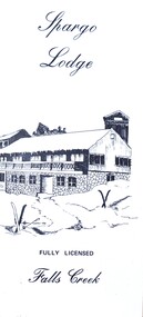 Falls Creek Historical Society
Flyer - Spargo Lodge
Ivan Spargo was a builder in Melbourne. In 1965 he and his wife Joy leased piece of land in Falls Creek and built Spargo Lodge. It was a dormitory style chalet designed to accommodate large groups and families. Their son, Rob and his wife Blanche purchased the site where the Falls Creek Hotel is today. In 1970 Rob’s sister Leonie and her husband Glenn joined the business, and they started operating in 1972. The family has been actively involved in the Falls Creek Community including the establishment of the Falls Creek Primary School and Falls Creek Search & Rescue. Rob also served as a member the Chamber and Resort Management Board. As the next generation stepped into the family business, Rob and Blanche retired to their home in Tawonga South in 2014 and Leonie and Glenn retired to Melbourne in 2017.This brochure is significant because it is linked to a prominent business and family in Falls Creek, Victoria. A small brochure publicising Spargo Lodge, Falls Creek. It is printed in brown text on buff coloured light card. When unfolded, one side shows a sketch of Spargo Lodge. The reverse side gives information about facilities and services, the tariff for regular and peak season, booking details and transport information.On front: Spargo Lodge FULLY LICENSED Falls Creekspargo lodge, falls creek accommodation, falls creek hotel -
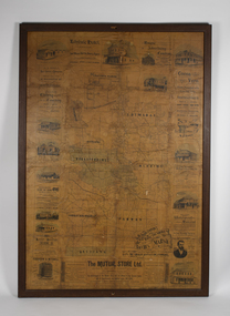 Bacchus Marsh & District Historical Society
Map, The Unique Advertising Combine, The Unique Combine's New Map of the Shire of Bacchus Marsh, 1890
This map was one of a number of similar maps produced for advertising purposes by a company called, 'The Unique Advertising Combine'. The company was located in Melbourne on Queens Walk. A brief item in the Bacchus Marsh Express newspaper on 29 March 1890 , page 2, indicated that subscribers to the Bacchus Marsh Express could obtain a copy of this map in the next issue of that newspaper. On the map is the detail that it was compiled by W.H. Bonney from official records supplied by D. A. Little, hire Secretary, (of Bacchus Marsh Shire).This map with its accompanying illustrations of local businesses and shops in Bacchus Marsh is an important documentary and visual snapshot of the town and district of Bacchus Marsh in the later part of the nineteenth century. The illustrations for some of the local businesses are the only known visual record of those particular buildings. The map is a rare surviving example of the material produced by The Unique Advertising Combine. Another similar example for the Shire of Mornington is held by the State Library of Victoria,A map of the Shire of Bacchus Marsh produced in March 1890. The map is mounted on a board and enclosed within a timber frame. The map includes an inset detail section showing the central part of the township of Bacchus Marsh including the main shopping and business streets. Land holdings with the first European land holders names indicated are included on the map. Rivers, creeks, major roads and the railway line are also shown on the map. Around the edges of the map are illustrated advertisements mostly for Bacchus Marsh businesses but which also includes some businesses located in Melbourne. maps bacchus marsh shire, shops bacchus marsh -
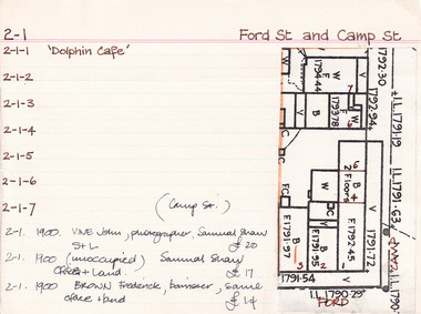 The Beechworth Burke Museum Research Collection
Card (Series) - Index Card, George Tibbits, Cnr Ford and Camp Streets, Beechworth, 1976
George Tibbits, University of Melbourne. Faculty of Architecture, Building and Town & Regional PlanningIndex system that support the research for Beechworth : historical reconstruction / [by] George Tibbits ... [et al]Arranged by street names of BeechworthEach index card includes: street name and number of property, image of property, allotment and section number, property owners and dates of ownership, description of the property according to rate records, property floor plan with dimensions.beechworth, george tibbitsbeechworth, george tibbits -
 City of Whittlesea Art Collection
Painting - Acrylic and ink on board, Pavel Wojtech, Land Makes Offer
-
 Wodonga & District Historical Society Inc
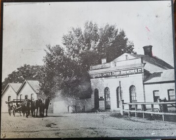
Photograph - Border United Co-op Breweries
The Border United Co-operative Breweries Limited was formed in 1911 by the amalgamation of The Albury Brewing and Malting Company Limited and The Anglo-Australian Brewery Company Proprietary Limited which operated breweries in Beechworth, Tallangatta and Yarrawonga. The Anglo-Australian Brewery was owned by the Billson family. By August the new plant was operating near the Union Bridge on the border of Victoria and NSW as shown in this photo. However the enterprise failed in August 1914 when not enough co-operative shares could be sold and also due to declining water quality. In December 1914 its spirit merchant’s license was transferred to the newly established Murray River Proprietary Company. In 1922, the brewery and 32 acres of land was sold to Mr E E Waite. Waite sold the buildings for removal.This image represents buildings related to early industries in the Albury-Wodonga region.Black and white image of brewery buildings. The image has been mounted on board.On building wall: "The BORDER INITED CO-OP BREWERIES LTD/LICENSED BREWERS"breweries northeast victoria, murray breweries, manufacturing history albury wodonga -
 Wodonga & District Historical Society Inc
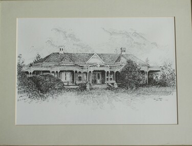
Drawing - Cambourne House, Kevin P. Clark, 1984
Cambourne homestead was built by 1903 for Rebecca S. Carkeek, who purchased the property in Wodonga in 1899. Cambourne is situated on the original Wodonga run which was established in 1836. The township of Belvoir, later renamed as Wodonga. In 1855 the pre-emptive right of 171 acres of the Wodonga run was granted and sold the following year. The allotments on which the five-acre Cambourne property developed, were purchased in 1873 and 1876, coinciding with the opening of the railway from Melbourne. The property was purchased by Rebecca Carkeek in June 1899, wife of William Carkeek, publican of Wodonga and shire councillor. Local architects Gordon and Gordon have been credited with the design of Cambourne. The house at Cambourne was built at some stage between 1900 and 1903 as a large single storey homestead. It was constructed in red brick with corrugated iron roof and encircling verandah. Cambourne is a probable work of architects Gordon and Gordon, it is amongst their best preserved and one of their few surviving buildings in Victoria. Today Cambourne remains on a reduced allotment due to the acquisition of land in 1972 by the Country Roads Board and in 2006 by Vic Roads for road works adjacent to the property.This drawing is significant as a representation of Cambourne in Wodonga. Cambourne is of historical significance due to its links with the early settlement of the district and as an example of closer settlement which occurred in regional centres of the State. Cambourne, Wodonga is also of architectural significance as a largely intact late Victorian style house with elaborate decorative cast iron work and distinctive transverse plan. As a probable work of architects Gordon and Gordon, it is amongst their best preserved and one of their few surviving buildings in Victoria. A framed drawing of historic home, Cambourne in Wodonga. The drawing has been mounted and framed.On bottom right corner" Kevin P. Clark 1984"cambourne wodonga, gordon and gordon architects, historic buildings wodonga, heritage buildings wodonga -
 Wodonga & District Historical Society Inc
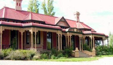
Photograph - Cambourne House
Cambourne homestead was built by 1903 for Rebecca S. Carkeek, who purchased the property in Wodonga in 1899. Cambourne is situated on the original Wodonga Run which was established in 1836. In 1855 the pre-emptive right of 171 acres of the Wodonga Run was granted and sold the following year. The allotments on which the five-acre Cambourne property developed, were purchased in 1873 and 1876, coinciding with the opening of the Railway from Melbourne. The property was purchased by Rebecca Carkeek in June 1899, wife of William Carkeek, Publican of Wodonga and Shire Councillor. Local architects Gordon and Gordon have been credited with the design of Cambourne. The house at Cambourne was built at some stage between 1900 and 1903 as a large single storey homestead. It was constructed in red brick with corrugated iron roof and encircling verandah. Cambourne is a probable work of architects Gordon and Gordon, it is amongst their best preserved and one of their few surviving buildings in Victoria. Today Cambourne remains on a reduced allotment due to the acquisition of land in 1972 by the Country Roads Board and in 2006 by Vic Roads for road works adjacent to the property.Cambourne, Wodonga is of architectural and historical significance to the State of Victoria.A set of coloured photos depicting Cambourne in Wodonga. Part of a collection documented a heritage listed pioneer home.cambourne wodonga, cambourne homestead wodonga, historic buildings wodonga -
 Wodonga & District Historical Society Inc
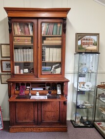
Furniture - Secretaire with Bookcase - the Watson Family of Wodonga
This secretaire once stood proudly in the de Kerilleau homestead at Wodonga. The homestead had been built for William Huon, son of the early pastoralist Paul Huon, in 1870 and named after the family's ancestral estate in France. The original lease of the Wodonga Run was granted to Paul Huon as No. 202 on 7th February 1837, about a year after his cousin Charles Huon had squatted on the land. Kenneth Darnton Watson bought de Kerilleau homestead in 1922 where the Watson family lived for three generations, caring for the land and serving the Wodonga community. Kenneth, his son Ian Darnton Watson and his grandson John Kenneth Darnton Watson all served on the Wodonga Council. John Kenneth Darnton Watson was born on 28 August 1960 in Wodonga. After completing his primary schooling locally, he boarded at Geelong College from 1973. John joined the rowing crews, starting in the 8th VIII crew and reaching the 1st VIII crew in 1978. He received multiple House colours awards for cross country, athletics and rowing and received School colours for rowing. On completion of his schooling, John spent some time jackarooing before studying farm management at Marcus Oldham College. He then returned home to de Kerilleau, Wodonga to manage the family property. In 1984 John married Christine Honybun, daughter of David Lewis Honybun and Marian Josephine Edkins. John and Christine had three sons. John was community minded and involved in a number of local organisations such as Apex and agricultural societies. He was elected to Wodonga City Council in 1997, serving until 2004. Due to increased pressure on available land to cater for the growth of Wodonga, some of the property was sold and in 2003 John donated 200 ha of Huon Hill ‘s western slopes to the City of Wodonga. After this time, he moved away from farming to become a Hungry Jack's franchisee. In 2009, the hard decision was made to sell de Kerilleau and John and his family moved into Wodonga. After sadly losing Christine to cancer in 2017, John became a member and Deputy Chairperson of the Albury Wodonga Regional Cancer Centre Trust Fund Board and Ambassador for the Sunshine Walk. Tragically after his own cancer battle, John Kenneth Darnton Watson passed away on 24 August 2023, aged 62 years following a life of service to the Wodonga community.This item is significant because it was owned by a prominent Wodonga family and came from a Historic Homestead in WodongaA secretaire with bookcase made of cedar. The bottom section has two cupboards with shelves. These doors support the desk when it is fully opened. Above this section is one large drawer, the front of which opens by pressing a small internal button on each side. The open drawer reveals a desk with a leather writing mat and several compartments. The desk is topped by a book shelf with 3 adjustable shelves. It has lockable glass doors.watson family wodonga, de kerilleau homestead, john watson -
 Wodonga & District Historical Society Inc
Mixed media - John Kenneth Darnton Watson and de Kerilleau Homestead
de Kerilleau was built for William Huon, son of the early pastoralist Paul Huon, in 1870 and named after the family's ancestral estate in France. The original lease of the Wodonga Run was granted to Paul Huon as No. 202 on 7th February 1837, about a year after his cousin Charles Huon had squatted on the land. Kenneth Darnton Watson bought de Kerilleau homestead in 1922 where the Watson family lived for three generations, caring for the land and serving the Wodonga community. Kenneth, his son Ian Darnton Watson and his grandson John Kenneth Darnton Watson all served on the Wodonga Council. The magnificent two storey brick homestead is built on ground above Wodonga Creek. The home of Georgian style consists of eleven rooms and a spacious cellar. At the rear of the main house in a separate single storey building was a large kitchen, pantry and accommodation for a cook and a housemaid. A feature of the homestead is the cast iron lace on the veranda and upper balcony, both supported by caste - iron pillars. The granite foundations of the home were quarried from the hill above the homestead. The enormous Moreton Bay Fig tree which stands to the side of the home was planted when Sir Charles Bowen visited de Kerilleau to mark the opening of the rail line that connects Victoria with New South Wales. Planted in 1873, it is still standing today. This painting was donated to the Wodonga Historical Society by George, Digby & Dugald Watson on behalf of the late John & Chris Watson. John Kenneth Darnton Watson was born on 28 August 1960 in Wodonga. After completing his primary schooling locally, he boarded at Geelong College from 1973. John joined the rowing crews, starting in the 8th VIII crew and reaching the 1st VIII crew in 1978. He received multiple House colours awards for cross country, athletics and rowing and received School colours for rowing. On completion of his schooling, John spent some time jackarooing before studying farm management at Marcus Oldham College in Geelong, Victoria. He then returned home to de Kerilleau, Wodonga to manage the family property. In 1984 John married Christine Honybun, daughter of David Lewis Honybun and Marian Josephine Edkins. John and Christine had three sons. John was community minded and involved in a number of local organisations such as Apex and agricultural societies. He was elected to Wodonga City Council in 1997, serving until 2004. Due to increased pressure on available land to cater for the growth of Wodonga, some of the property was sold and in 2003 John donated 200 ha of Huon Hill ‘s western slopes to the City of Wodonga. After this time, he moved away from farming to become a Hungry Jack's franchisee. In 2009, the hard decision was made to sell de Kerilleau and John and his family moved into Wodonga. After sadly losing Christine to cancer in 2017, John became a member and Deputy Chairperson of the Albury Wodonga Regional Cancer Centre Trust Fund Board and Ambassador for the Sunshine Walk. Tragically after his own cancer battle, John Kenneth Darnton Watson passed away on 24 August 2023, aged 62 years following a life of service to the Wodonga community.This item is significant because it was owned by a prominent Wodonga family and came from a Historic Homestead in WodongaA coloured portrait of John Kenneth Darnton Watson and a painting of de Kerilleau Homestead, the Watson Family home for three generations. The portrait was taken by Peter Charlesworth. The painting is the work of D.K. Ross in 1991.watson family wodonga, de kerilleau homestead, john watson, peter charlesworth -
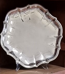 Wodonga & District Historical Society Inc
Decorative object - Silver Tray from John Kenneth Darnton Watson, Wodonga
This silver tray was donated by the family of John Watson and was used when they lived in de Kerilleau Homestead for three generations. de Kerilleau Homestead was built for William Huon, son of the early pastoralist Paul Huon, in 1870 and named after the family's ancestral estate in France. The original lease of the Wodonga Run was granted to Paul Huon as No. 202 on 7th February 1837, about a year after his cousin Charles Huon had squatted on the land. Kenneth Darnton Watson bought de Kerilleau homestead in 1922 where the Watson family lived for three generations, caring for the land and serving the Wodonga community. Kenneth, his son Ian Darnton Watson and his grandson John Kenneth Darnton Watson all served on the Wodonga Council. John Kenneth Darnton Watson was born on 28 August 1960 in Wodonga. After completing his primary schooling locally, he boarded at Geelong College from 1973. John joined the rowing crews, starting in the 8th VIII crew and reaching the 1st VIII crew in 1978. He received multiple House colours awards for cross country, athletics and rowing and received School colours for rowing. On completion of his schooling, John spent some time jackarooing before studying farm management at Marcus Oldham College in Geelong, Victoria. He then returned home to de Kerilleau, Wodonga to manage the family property. In 1984 John married Christine Honybun, daughter of David Lewis Honybun and Marian Josephine Edkins. John and Christine had three sons. John was community minded and involved in a number of local organisations such as Apex and agricultural societies. He was elected to Wodonga City Council in 1997, serving until 2004. Due to increased pressure on available land to cater for the growth of Wodonga, some of the property was sold and in 2003 John donated 200 ha of Huon Hill‘s western slopes to the City of Wodonga. After this time, he moved away from farming to become a Hungry Jack's franchisee. In 2009, the hard decision was made to sell de Kerilleau and John and his family moved into Wodonga. After sadly losing Christine to cancer in 2017, John became a member and Deputy Chairperson of the Albury Wodonga Regional Cancer Centre Trust Fund Board and Ambassador for the Sunshine Walk. Tragically after his own cancer battle, John Kenneth Darnton Watson passed away on 24 August 2023, aged 62 years following a life of service to the Wodonga community.This item is significant because it was owned by a prominent Wodonga family and came from a Historic Homestead in WodongaA circular silver tray with an embossed design around the outer edge.watson family wodonga, de kerilleau homestead, john watson, peter charlesworth -
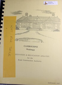 Wodonga & District Historical Society Inc
Booklet - Cambourne Wodonga : Conservation & Relocation Analysis for the Road Construction Authority, John & Thurley O'Conner, 1987
Research paper into the viability of relocating Cambourne Homestead in 2006 in order to make way for the widening and upgrade of the Hume Highway.non-fictionResearch paper into the viability of relocating Cambourne Homestead in 2006 in order to make way for the widening and upgrade of the Hume Highway. cambourne homestead wodonga, heritage building wodonga, carkeek family, potter family, building relocation -
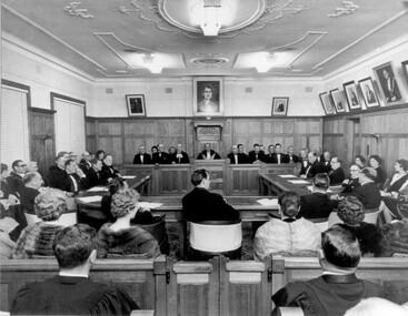 City of Kingston
Photograph - Black and white, 1962
Local government for Moorabbin began in 1862 when the area was separated from Brighton with the creation of the Moorabbin Roads Board. This meeting commemorated the centenary of local government in 1962.1862 saw the beginnings of local government in the Moorabbin district when the area was separated from Brighton with the creation of the Moorabbin Roads Board. Moorabbin was declared a shire in 1871 and a city in 1934. While tinkering with boundaries occurred over time, the first major severance from Moorabbin was when the Borough of Sandringham was created in 1917. Three years later, after persistent agitation, on May 27, 1920 Mordialloc, Parkdale and Mentone became part of the new Borough of Mordialloc. With this change the Shire of Moorabbin no longer had authority for land with a frontage to Port Phillip Bay. In 1994 councils across Victoria were amalgamated and the City of Moorabbin was divided between the cities of Kingston and Glen Eira. The City of Kingston is made up the former cities of Chelsea, Mordialloc, Moorabbin, Oakleigh and Springvale.Black and white image of inside of Moorabbin Council Chambers, with a meeting (possibly staged) in progress. Council members are seated behind a bench which connects to a horseshoe shaped table. All in attendance are in formal attire. Men are wearing black tie and the women in the audience (with backs to camera) are wearing fur coats or stoles.Black printed text of white round sticker adhered to reverse: 191 Handwritten in red ink: 80%moorabbin, council, chambers, council meeting, centenary -
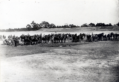 Whitehorse Historical Society Inc.
Photograph - Black & white photograph, Clearing Land for Mitcham Reservoir
Black and white photo of Teams of Horses clearing Land for M.M.B.W. Reservoir at Mitcham.meagher, ray, melbourne and metropolitan board of works, mitcham reservoir -
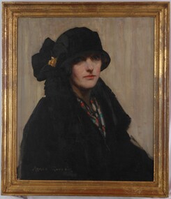 Glenelg Shire Council Cultural Collection
Painting, Agnes Goodsir, Cherry (aka "Portrait of a Lady"), 1924
Art collection Previously located in History House. Previous Exhibition:"In a picture land over the sea ...Agnes Goodsir 1864-1939." Exhibition developed by Bendigo Art Gallery and toured from May 1998 to June 1999. Item of the Month, exhibited in Portland Foyer April 2005.Portrait of a woman dressed in black. The woman appears to be seated and is facing the viewer. She wears a black overcoat with a blue, red and white scarf. She also wears a black hat with a gold clasp. The plain background is predominately grey. The work is framed in a gilded, moulded frame and has an exposed canvas.Front: Agnes Goodsir Back: A clear plasstic pocket is attached to the backing board and contains: a fragment of an old French label and a small fragment of paper with the signature "R.D...." on it.female artists, female artist, agnes goodsir, women artist, female portrait, portrait painting, portrait, cherry -
![Book, Leslie Arthur Schumer, Henry Dendy and his emigrants / [by] Leslie A. Schumer, 1975](/media/collectors/4f729f7b97f83e03086018a5/items/590860a8d0ce9c14e834a413/item-media/5bac378021eb061568d29027/item-fit-380x285.jpg) Eltham District Historical Society Inc
Eltham District Historical Society IncBook, Leslie Arthur Schumer, Henry Dendy and his emigrants / [by] Leslie A. Schumer, 1975
Henry Dendy (1800-1881) is best known as the founder of Brighton. It is not well known that years later he lived far longer at Eltham than he did at Brighton. In 1840 whilst still in England, he bought eight square miles of unspecified land in the Port Phillip district. This entitled him to bring a number of other people to the colony and in 1841 he arrived in Williamstown in the York with his family and 139 others. He took up this land entitlement at what is now Brighton and most of the emigrants settled there. He encountered financial problems and lost his interest in the estate in 1844. He left Brighton in 1847. He successfully not always successfully became a brewer at Geelong, a sheep farmer at Christmas Hills and Upper Moira, a flour miller at Eltham, a sheep farmer again at Werribee and finally a copper miner at Walhalla. Dendy came to Eltham in 1856 after having spent a year in England, he purchased about 5 acres of land in two parts situated each side of Maria Street (Main Road). There was a steam flour mill on that part of the land adjoining the Diamond Creek. He became prominent in local affairs serving for a time on the Eltham District Roads Board including one term as President. Dendy’s wife Sarah died at Eltham in 1860 and also in that year he was appointed Chairman of a committee to establish a Church of England in Eltham. He donated one of his Pitt Street lots for this purpose. St Margaret’s Church was opened on this site in 1861. In 1867 Dendy sold his mill to W F Ford and moved to Werribee and then Walhalla where he remained until his death. He is buried in the Walhalla cemetery. Part of the land on which the Eltham Community Reception Centre stands was the site of Dendy’s house and Mill. Some of the old trees on the site could well have been planted in Dendy’s time. Much of this information was obtained from the book “Henry Dendy and his Emigrants” by L A Schumer. ISBN 095971040X Paperback; viii, 88 p. : maps ; 22 cm. [written inside front cover] To J.W. Wainbech(?) with the author's compliments and thanks. 22/12/75 [and signed by the author on the cover page]henry dendy, brighton (vic.), emmigration, pioneers -
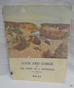 Flagstaff Hill Maritime Museum and Village
Book - Reference - history, Terang Express, Loch Ard Gorge, 1954
HISTORY OF THE LOCH ARD The LOCH ARD belonged to the famous Loch Line which sailed many ships from England to Australia. Built in Glasgow by Barclay, Curdle and Co. in 1873, the LOCH ARD was a three-masted square rigged iron sailing ship. The ship measured 262ft 7" (79.87m) in length, 38ft (11.58m) in width, 23ft (7m) in depth and had a gross tonnage of 1693 tons. The LOCH ARD's main mast measured a massive 150ft (45.7m) in height. LOCH ARD made three trips to Australia and one trip to Calcutta before its final voyage. LOCH ARD left England on March 2, 1878, under the command of Captain Gibbs, a newly married, 29 year old. She was bound for Melbourne with a crew of 37, plus 17 passengers and a load of cargo. The general cargo reflected the affluence of Melbourne at the time. On board were straw hats, umbrella, perfumes, clay pipes, pianos, clocks, confectionary, linen and candles, as well as a heavier load of railway irons, cement, lead and copper. There were items included that intended for display in the Melbourne International Exhibition in 1880. The voyage to Port Phillip was long but uneventful. At 3am on June 1, 1878, Captain Gibbs was expecting to see land and the passengers were becoming excited as they prepared to view their new homeland in the early morning. But LOCH ARD was running into a fog which greatly reduced visibility. Captain Gibbs was becoming anxious as there was no sign of land or the Cape Otway lighthouse. At 4am the fog lifted. A man aloft announced that he could see breakers. The sheer cliffs of Victoria's west coast came into view, and Captain Gibbs realised that the ship was much closer to them than expected. He ordered as much sail to be set as time would permit and then attempted to steer the vessel out to sea. On coming head on into the wind, the ship lost momentum, the sails fell limp and LOCH ARD's bow swung back. Gibbs then ordered the anchors to be released in an attempt to hold its position. The anchors sank some 50 fathoms - but did not hold. By this time LOCH ARD was among the breakers and the tall cliffs of Mutton Bird Island rose behind the ship. Just half a mile from the coast, the ship's bow was suddenly pulled around by the anchor. The captain tried to tack out to sea, but the ship struck a reef at the base of Mutton Bird Island, near Port Campbell. Waves broke over the ship and the top deck was loosened from the hull. The masts and rigging came crashing down knocking passengers and crew overboard. When a lifeboat was finally launched, it crashed into the side of LOCH ARD and capsized. Tom Pearce, who had launched the boat, managed to cling to its overturned hull and shelter beneath it. He drifted out to sea and then on the flood tide came into what is now known as LOCH ARD Gorge. He swam to shore, bruised and dazed, and found a cave in which to shelter. Some of the crew stayed below deck to shelter from the falling rigging but drowned when the ship slipped off the reef into deeper water. Eva Carmichael had raced onto deck to find out what was happening only to be confronted by towering cliffs looming above the stricken ship. In all the chaos, Captain Gibbs grabbed Eva and said, "If you are saved Eva, let my dear wife know that I died like a sailor". That was the last Eva Carmichael saw of the captain. She was swept off the ship by a huge wave. Eva saw Tom Pearce on a small rocky beach and yelled to attract his attention. He dived in and swam to the exhausted woman and dragged her to shore. He took her to the cave and broke open case of brandy which had washed up on the beach. He opened a bottle to revive the unconscious woman. A few hours later Tom scaled a cliff in search of help. He followed hoof prints and came by chance upon two men from nearby Glenample Station three and a half miles away. In a state of exhaustion, he told the men of the tragedy. Tom returned to the gorge while the two men rode back to the station to get help. By the time they reached LOCH ARD Gorge, it was cold and dark. The two shipwreck survivors were taken to Glenample Station to recover. Eva stayed at the station for six weeks before returning to Ireland, this time by steamship. In Melbourne, Tom Pearce received a hero's welcome. He was presented with the first gold medal of the Royal Humane Society of Victoria and a £1000 cheque from the Victorian Government. Concerts were performed to honour the young man's bravery and to raise money for those who lost family in the LOCH ARD disaster. Of the 54 crew members and passengers on board, only two survived: the apprentice, Tom Pearce and the young woman passenger, Eva Carmichael, who lost all of her family in the tragedy. Ten days after the LOCH ARD tragedy, salvage rights to the wreck were sold at auction for £2,120. Cargo valued at £3,000 was salvaged and placed on the beach, but most washed back into the sea when another storm developed. The wreck of LOCH ARD still lies at the base of Mutton Bird Island. Much of the cargo has now been salvaged and some was washed up into what is now known as LOCH ARD Gorge. Cargo and artefacts have also been illegally salvaged over many years before protective legislation was introduced. One of the most unlikely pieces of cargo to have survived the shipwreck was a Minton porcelain peacock - one of only nine in the world. The peacock was destined for the Melbourne International Exhibition in 1880. It had been well packed, which gave it adequate protection during the violent storm. Today, the Minton peacock can be seen at the Flagstaff Hill Maritime Museum in Warrnambool. From Australia's most dramatic shipwreck it has now become Australia's most valuable shipwreck artefact and is one of very few 'objects' on the Victorian State Heritage Register. Flagstaff Hill’s collection of artefacts from LOCH ARD is significant for being one of the largest collections of artefacts from this shipwreck in Victoria. It is significant for its association with the shipwreck, which is on the Victorian Heritage Register (VHR S417). The collection is significant because of the relationship between the objects, as together they have a high potential to interpret the story of the LOCH ARD. The LOCH ARD collection is archaeologically significant as the remains of a large international passenger and cargo ship. The LOCH ARD collection is historically significant for representing aspects of Victoria’s shipping history and its potential to interpret sub-theme 1.5 of Victoria’s Framework of Historical Themes (living with natural processes). The collection is also historically significant for its association with the LOCH ARD, which was one of the worst and best known shipwrecks in Victoria’s history. Book, Loch Ard Gorge: The Story of a Shipwreck by Alice Goldstraw. First published 1948, Third printing November 1954. Inscription inside front cover in blue pen, signed by the author. Soft covered book containing the story of the wreck of the Loch Ard, written in poetry. Each page has a decorative border. One page has photographs, black and white, of people and the Loch Ard Gorge cavesInside front cover, script in blue ink "To Mrs Slade, with kind regards, from Alice Goldstraw"flagstaff hill, warrnambool, shipwrecked coast, flagstaff hill maritime museum, maritime museum, shipwreck coast, flagstaff hill maritime village, great ocean road, loch line, loch ard, captain gibbs, eva carmichael, tom pearce, glenample station, mutton bird island, loch ard gorge, the story of a shipwreck, book, alice goldstraw, terang express press, loch ard gorge whipwreck, ship loch ard -
 Flagstaff Hill Maritime Museum and Village
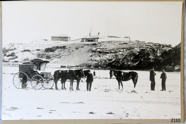
Photograph - Scene - Warrnambool, C. 1854-1871
This is an image of the Warrnambool Lighthouse Complex on Middle Island in 1854. The Store, Lighthouse Keeper's Quarters, Lighthouse and Flagstaff are in the background. The foreground shows a covered buggy drawn by two horses and a person in attendance, and another wheeled vehicle behind it with a figure nearby. There is a saddled horse to the right with two males in conversation nearby. The ground is soft, perhaps the riverbed or sandy shore. THE LIGHTHOUSE KEEPERS Lighthouse Keepers were responsible for keeping their Lighthouse’s lights shining at night. They kept a lookout for passing vessels and changes in weather. They were expected to clean, polish and maintain the equipment and buildings. They kept regular and detailed records of who was on watch, and the time the light was lit, trimmed and extinguished. They kept a journal about other events that occurred. They keep regular, accurate Meteorological Logs. It was expected that they were competent in Morse code signalling. They would be called to help in times of disasters and shipwrecks and to give official statements about these events. Many Lighthouse Keepers also volunteered as members of the lifeboat crew. The Lady Bay lighthouses were officially classified as small, so the Keepers had the official titles of Senior Assistant Lighthouse Keeper and Assistant Lighthouse Keeper. They were employed by the Public Service and paid rent to live in the Lighthouse Quarters. They were compulsorily retired at the age of 60, with most receiving a superannuation payment. Despite their time-consuming duties, there was time to follow hobbies and crafts such as growing vegetables, playing musical instruments, making models of buildings including lighthouses, and crafting furniture pieces. An example of a keeper’s skills is the carved fire screen made by /assistant Keeper Thomas Hope in the late 19th century and displayed in the Lighthouse Keeper’s cottage at Flagstaff Hill. Both Alexander and Farncombe had served under Senior Keeper Robert Deverell, who was the first and only Senior Lighthouse Keeper at the Middle Island Complex. John Alexander was the Assistant Keeper in the 1850s. Andrew Farncombe was the last Assistant Keeper at Middle Island, serving there with his family from 1864 to 1871. During 1871 and 1872 the Lighthouse Complex was moved to Flagstaff Hill on Merri Street. Farncombe and Deverell then became the first Keepers and occupants of the Lady Bay Lighthouse Complex at Flagstaff Hill. They continued their service together; overall, Deverell served from 1859 to 1885 and Farncombe from 1864 to 1974. WARRNAMBOOL'S LADY BAY LIGHTHOUSE COMPLEX - The original Lighthouse Complex was built on Middle Island in 1858-1859 then transferred stone-by-stone to Flagstaff Hill in 1871. The Complex comprised the Lighthouse, the Lighthouse Keepers’ Quarters and a Privy. The bluestone Keeper’s Quarters was a cottage divided into two compartments, one for the Senior Keeper and his family, the other for the Assistant Keeper and his family. The bluestone Store was divided into three; a store, a workshop, and an oil store (or office). The Privy comprised a small building also divided into two separate, back-to-back toilets, one for each Keeper and his family. In the 1970s the Flagstaff Hill Planning Board was set up under the chairmanship of John Lindsay. The Board was to make recommendations to the Warrnambool City Council regarding the use of the buildings and the rest of the Crown Land on the site. The Flagstaff Hill Maritime Village opened in 1975 and began renovating the Cottage in stages, during which time evidence of a 1920s fire was found in the eastern section of the cottage. Additions of a porch on the west and a washroom on the east were made in the 1980s. The western part of the building is now a Shipwreck Museum and the east has returned to a late 19th-century Lighthouse Keeper’s cottage and includes the screen made by Assistant Lighthouse Keeper Thomas Hope in the late 19th century. Hope served two periods of time at the Lighthouse. This photograph is significant as a visual record of the original Warrnambool Lighthouse Complex on Middle Island, the origin of what is now the Lady Bay Lighthouse Complex. The photograph is significant for its connection to the Complex, which is now listed on the Victorian Heritage Register, H1520, for being of historical, scientific (technological) and architectural significance to the State of Victoria. The Complex is significant as an example of early colonial development. The photograph is significant for its connection with the important navigational function of the Lighthouses, a function still being performed to this day. The photograph is also significant as it shows an example of buildings organised by the Public Works Department in Victoria in the mid-to-late 19th century. The structures tare still stand strong. Photograph of horses, a buggy and three gentlemen in the foreground and the background shows a lighthouse and accompanying buildings. Printed in black and white. (Another two horse-drawn vehicles are partially visible). The subject is the Lighthouse Complex on Middle Island, Warrnambool, dated between 1854 and 1871.An inscription is handwritten in black pen on the back of the mounting board."The lighthouse and accompanying buildings were / established on Middle Island in 1854, as this / picture shows. In 1871 they were moved to their / present site on Flagstaff Hill."flagstaff hill, flagstaff hill maritime museum, flagstaff hill maritime village, warrnambool, maritime museum, shipwreck coast, lighthouse keeper's cottage, lighthouse residence, lighthouse, chart room, quarters, privy, middle island, beach lighthouse, obelisk, lighthouse complex, lady bay complex, warrnambool port, warrnambool harbour, lady bay, keepers, lighthouse keeper, upper lighthouse, lower lighthouse, assistant keeper, ports and harbours, cottage, meteorological record, 1854, 1871 -
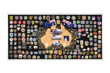 Department of Energy, Environment and Climate Action
Display board
The Forests Commission and its successors continuously encouraged bushfire research and innovation. In 1946 a large parcel of industrial land was purchased at North Altona as a fire cache and workshop. The Altona workshop became a hotbed of new technological innovation… an exhilarating place where lots of things were invented and tested. In fact, a lot of Australia’s pioneering equipment development was led by staff from Altona, often in collaboration with other State forestry and fire authorities. The CSIRO also contributed significantly. The US Forest Service, the US Bureau of Land Management and US State agencies such as the California Department of Forestry and Fire (CalFire) as well as the Canadian Forest Service faced similar challenges and proved strong and willing partners in sharing knowledge, ideas, equipment and expertise over many decades. This collection of badges is testament to the relationships that were forged across the globe with the Altona workshop. Large display panel featuring many fire service badgesforests commission victoria (fcv), bushfire, bushfire aviation -
Eltham District Historical Society Inc
Folder, George Fletcher, 1878
Folder of information on George Fletcher, Councillor, Steels Creek, 1878. Fletcher, George, Yarra Flats was born in Herefordshire, England, in 1830, and came to Australia, landing in Adelaide, S.A. in 1851. A year afterwards he came to Victoria, but after visiting the Bendigo goldfields and other places returned to Adelaide. In 1859, he again came to Victoria, was employed on the View Hill station, Yarra Flats, and stayed there for four years. In 1867 he selected 80 acres under the Land Act of 1865, and afterwards an additional 320 acres on Steel's Creek, where he now carries on faming and dairying. During htis time Mr. Fletcher has been a member of the board of advice for the east riding of the shire of Eltham, and about twelve years ago he was elected a member of the shire council, and continued so for a term. Mr Fletcher was married in 1859, and has a family of four sons and four daughters. From "Victoria and its Metropolis: Past and Present" written in 1888 by Alexander Sutherland. Chapter 19, "The Upper Yarra District" pages [402] - 415. Page 405. Includes descriptions of some townships and short biographies of local residents. george fletcher, steels creek, pioneer -
 Melbourne Tram Museum
Document, Melbourne & Metropolitan Tramways Board (MMTB), "MMTB Road traffic Regulations 1958", Jan. 1958
Document produced by the MMTB for the information of Traffic Officers and Employees in Jan. 1958 - contains a reprint of the Victorian Road Traffic Regulations detailings the road rules. Extracted from the Jan. 1958 issue of Royal Auto Journal by the RACV. Section 13 details the regulations for passing stationary trams and safety zones. Has a McLean and Son advertisement for a land sale in Indented Head, Geelong region.Demonstrates a method the MMTB used to inform its staff of the road traffic regulations.Document - brown card covers side stapled with an extract from RACV Royal Auto Jan. 1958 pages 21 to 30.regulations, racv, mmtb, information, safety zones, traffic control -
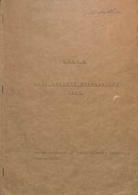
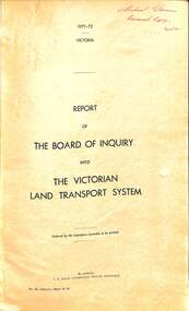 Victorian Railway History Library
Book, Board of Inquiry, Report of The Board of Inquiry into The Victorian Land Transport System, 1972
... Report of The Board of Inquiry into The Victorian Land....250. Report of The Board of Inquiry into The Victorian Land ...A report by the Board of Inquiry into the Victorian land transport system in the years 1971 to 1972.maps. p.250.non-fictionA report by the Board of Inquiry into the Victorian land transport system in the years 1971 to 1972.land transport - victoria - report, railroad operations - victoria - history -
 Eltham District Historical Society Inc
Photograph - Digital Photograph, Marguerite Marshall, Eltham Lower Park, 20 April 2008
Originally a race course, the park has brought the community together with a variety of activities. Published: Nillumbik Now and Then / Marguerite Marshall 2008; photographs Alan King with Marguerite Marshall.; p45 Once used for horse racing, which attracted visitors from Melbourne, the Eltham Lower Park has brought the community together with a wide range of activities. Horse riding is now enjoyed as a recreation in the park as are other sports. The park also includes the Diamond Valley Railway miniature trains and a sanctuary for the rare and vulnerable Eltham Copper Butterfly. Eltham Lower Park, with other parks, forms an almost continuous green band from Eltham’s centre, along the Diamond Creek to the Yarra River.1 Before European settlement the Wurundjeri people met on this land, particularly at the junction of the Diamond Creek with the Yarra River, which they called Birr-arung. This is commemorated by the sculpture, Not just a Pretty Place by Aleks Danko, winner of the 2000 Nillumbik Art in Public Places Award. The first European to settle here was probably Henry Foley, who in 1841 used it as part of his pastoral run. Foley sold his leasehold to Joseph Wilson in 1845, who soon after sold it to Frederick Falkiner. During the 1840s the future park was part of a government square mile (2.6 sqkm) reserve, north of the Yarra, within the Parish of Nillumbik, later named Eltham. Soon the land was used for horse racing after nearby residents cleared ten acres (4ha) in the early 1850s. A three-quarter of a mile (1.2km) race secured the winner the £10 Publican’s Prize. In response to popular demand, the newly formed Eltham District Road Board petitioned the Surveyor General of the Colony of Victoria, in 1856, for 36 acres (14.6ha) of crown land for a racecourse and recreation. By 1858 the Eltham races had become an institution. ‘Many skirmishes occurred and the way home was paved with temptation, with sly-grog for sale.3 In the early 1870s, two jockeys were sons of the police officer in charge of the Eltham Police Station, Miles S Lyons. Another ten acres (4ha) was added to the area in 1866 and 12 acres (4.8ha) – Hohnes Hill – in 1870. In 1866, two acres (0.8ha) on the creek banks became an animal pound with William Walsh the pound keeper in 1870, but this was later incorporated into the park. By 1877 the area was called a public park but horse racing and training continued into the 1920s. In the mid-1900s trotters were trained on a circuit road. In 1953 the Eltham Pony Club was established and used a cross-country course on Hohnes Hill. From the mid 1950s the club held the Eltham Easter Fair at the park, later to include a procession along Main Road from the town centre to the park. The park also attracted picnic parties and campers from the inner suburbs as did Wingrove Park, and businesses catering for visitors, sprang up on the opposite side of Main Road. Bus-loads of school children visited the park for Gould League bird days in the 1960s. In 1979 the Eltham Shire Council bought Lenister Farm, linking the park with the Yarra River. The Lenister Farm wetland includes a bird hide, viewing platform and interpretive signs.5 Pioneer Henry Stooke, later Road Board chairman, bought the 11 acres (4.5ha) - later to become Lenister Farm - from the Crown in 1862. Stooke never lived on this site and the two houses at Lenister Farm were built in the 20th century. Since its formation in 1871, the Council has controlled this crown land, which it named Eltham Park. But in the 1920s Eltham Council bought land near the town centre for a park, which it named Eltham Central Park. To avoid confusion the Council renamed Eltham Park, Eltham Lower Park. Since 2004 the Yarra footbridge has linked the park with the Yarra Valley Metropolitan Park and the Main Yarra Trail.This collection of almost 130 photos about places and people within the Shire of Nillumbik, an urban and rural municipality in Melbourne's north, contributes to an understanding of the history of the Shire. Published in 2008 immediately prior to the Black Saturday bushfires of February 7, 2009, it documents sites that were impacted, and in some cases destroyed by the fires. It includes photographs taken especially for the publication, creating a unique time capsule representing the Shire in the early 21st century. It remains the most recent comprehenesive publication devoted to the Shire's history connecting local residents to the past. nillumbik now and then (marshall-king) collection, eltham lower park, eltham park -
 Bendigo Historical Society Inc.
Document - MISS G ALICE JONES COLLECTION: ACCOUNT
Pink paper dated Mar 30, Apr 1, 1925, May 14, 1926, and 30/6/26. Central Red White & Blue gold Mining Co. N.L. to Miss G. Alice Jones. Land Tax Return. Mar 30 Attending Mr. Jewell drafting return for 1924-25. Apr 1 Attending Mr. Jewell perusing return as typed and drawing letter to accompany. May 14, 1926, mine Drainage Board. Attending Mr. Stanistreet who stated position and suggesting negotiations. Cost £1 1 0. Pd written on the end. R414 delivered by V B? 1/7/26.the miss g.alice jones collection - account, central red white & blue gold mining co n l, mr jewell, mine drainage board, mr stanistreet -
 Eltham District Historical Society Inc
Photograph - Digital Photograph, Alan King, Garden Hill, Eltham-Yarra Glen Road, Kangaroo Ground, 3 February 2008
The original house was built around 1850 was one of Kangaroo Ground's earliest homes, part of which remains today. Built by Scottish farmer Andrew Harkness who acquired the property in 1849 at the top of the hill with magnificent panoramic views as far as Kinglake, the same year he married Sarah Oswin. The property was known as Garden Hill from at least 1865. Andrew and Sarah had four sons and five daughters. Harkness was a founder of the Kangaroo Ground School and one of the first to suggest establishing the Eltham District Road Board (1858-71) of which he was a member, the pre-cursor to the Shire of Eltham (1871-1994). He was also a Trustee of the Kangaroo Ground Cemetery. His daughter Fanny married farmer Alexander White who purchased the property in 1893. Alexander White died in 1906 and ownership transferred to Fanny White. Son, Robert White was a Councillor of the Shire of Eltham at the time the Shire acquired two acres of land on the adjacent property from the Mess brothers for the creation of the Shire of Eltham Memorial Park (1921) in which the Shire of Eltham War Memoirial tower was erected (1926). Fanny White donated a small section of land from the Garden Hill property to facilitate entry access to the park. The White family sold the property to Sir Herbert Gepp in 1925. Covered under Heritage Overlay, Nillumbik Planning Scheme. Published: Nillumbik Now and Then / Marguerite Marshall 2008; photographs Alan King with Marguerite Marshall.; p29This collection of almost 130 photos about places and people within the Shire of Nillumbik, an urban and rural municipality in Melbourne's north, contributes to an understanding of the history of the Shire. Published in 2008 immediately prior to the Black Saturday bushfires of February 7, 2009, it documents sites that were impacted, and in some cases destroyed by the fires. It includes photographs taken especially for the publication, creating a unique time capsule representing the Shire in the early 21st century. It remains the most recent comprehenesive publication devoted to the Shire's history connecting local residents to the past. nillumbik now and then (marshall-king) collection, kangaroo ground