Showing 112797 items
matching tracks/roads
-
 Phillip Island and District Historical Society Inc.
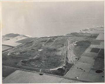
Photograph, J D Payens, Aerial photo of Grand prix track and painting of 1932 Grand Prix
The Circuit was built in the 1950's and opened in 1956. The circuit was closed in 1962 due to lack of finance for repair work to the track. In 1964 Len Lukey purchased the cirtuit and reopened in 1967, but once again was closed in 1978 as not suitable for modern racing. It was used only for Historic Rallies and the like until 1982. In 1985 The Circuit was purchsed by Placetac Pty Ltd. The Circuit was refurbished in 1988. In 1989 The Australian Motorcycle Grand Prix - 1st World Championship Round - was held at the Circuit on 9th April. 2004 the Circuit and surrounding land was purchased by The Linfox Group who still own it to this day (8/10/2016).Black & White aerial view of the Phillip Island Grand Prix Race Track with Bass Strait in the background and painting of 1932 Grand PrixJ. D. Payne - Commercial Photographer, Rice Street, Moorabbin. Phone: XL 3144phillip island g p circuit, grand prix circuit phillip island, len lukey, linfox group, jean parle, bill thompson, keith riordan, bugatti, 1932 grand prix -
 Whitehorse Historical Society Inc.
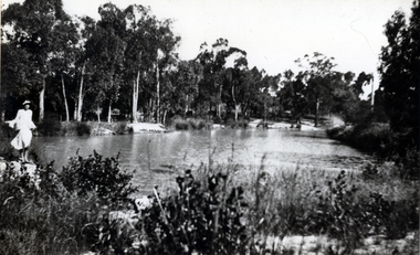
Photograph - B;ack and white photograph, Old Dam - Corner of Blackburn and Canterbury Road Blackburn, c. 1922
Dam on the corner of Canterbury and Blackburn Roads where the Bellbird Hospital now stands.Black & white photo of S.W. corner of Blackburn Road and Canterbury Road c1922. Mrs wellman is standing on rock.wellman mrs, blackburn road blackburn, canterbury road blackburn -
 Ringwood and District Historical Society
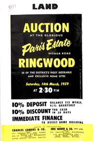
Flyer, Land Auction Advertisement, Paris Estate, Ringwood, Vic. - 1959
Double sided single page black and yellow printed advertisement for auction of home sites at Paris Estate, Wonga Road, Ringwood, Vic., on Saturday, 14th March, 1959, with terms of sale, locality map, subdivision features and summary of local services.Subdivision includes Mullum Mullum Road, Hendra Grove, Sunhill Road, and Wonga Road. Agents in conjunction: Charles Somers & Co., South Yarra and Melbourne, and Eric Weber & Co., Melbourne and East Melbourne. -
 Clunes Museum
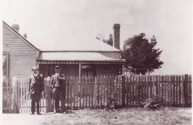
Photograph
BLACK AND WHITE PHOTOGRAPH OF TWO MEN STANDING IN FRONT OF A WEATHER BOARD HOUSE - WOLFENDEN HOUSE. CORNER LESLIE AND SMEATON ROAD CLUNES.HAND WRITTEN IN BLACKLEAD PENCIL WOLFENDEN HOUSE CNR. LESLIE AND SMEATON ROAD.local history, photography, photographs, early citizens -
 Ballarat Tramway Museum
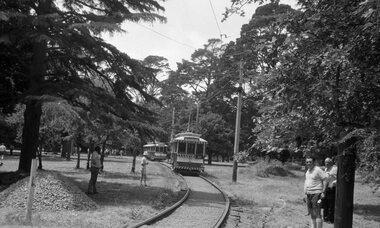
Photograph - B&W print of donated negative - set of 3, 1/02/1975 12:00:00 AM
Donated black and white negatives and colour laser printer images of scanned images of tramcar of trams on the depot access track and depot tracks of the BTPS on the official opening day, 1 Feb. 1975. 1328.1 - 26 on access track - photo taken from the level crossing - has level crossing in the foreground. 1328.2 - 40, 27 and 14 on depot fan, 14 on 1 road. 1328.3 - 27 and 14 on 2 and 1 roads respectively of depot fan. Original negs scanned at 3200dpi 12/5/2020 and images updated. see 1974-75 BTPS Annual Report.tramways, trams, btps, btps depot, access track, opening, tram 40, tram 27, tram 14, tram 26 -
 Melbourne Tram Museum
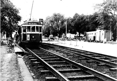
Photograph - Set of two Black & White Photograph/s, 1950's? to 1960's
Black and white photograph of trams on temporary track in St Kilda Road, Melbourne, late 1950's or early 1960's. Shows timber sleepered track, temporary huts, a transport bus, air compressor and temporary barriers and kerosene lamps. .1 - W2 379 outbound on temporary track, destination of Malv Tn Hall (Malvern Town Hall) route 6B. .2 - W2 262, followed by 775 and two other trams. W2 has the destination of East Malvern Darling Road, Route 4D. Printed on Fujichrome paper. Not known who took the photograph or when it was printed.Stamped in black ink on back "TMSV Sales"trams, tramways, st kilda rd, temporary track, reconstruction, malvern town hall, darling rd, tram 379, tram 262, tram 775 -
 Pyrenees Shire Council
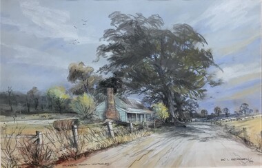
painting, Ian L Anderson, School Road, Waterloo by Ian L Anderson, 1995
significant as a work of art by local Pyrenees artist, locally significant to the Central Highlands Region of Victoria as a representation of local landscape and/or culture pastel drawing of a street scene with old house, trees and unpaved road"Signed: IAN L ANDERSON 95 (lower right) Titled: SCHOOL ROAD - WATERLOO (lower centre) Verso (affixed): ""SCHOOL ROAD - WATERLOO"" PASTEL AND CHARCOAL PENCIL PAINTING by IAN L. ANDERSON 14 MILLAR CRESCENT MT WAVERLEY 3145 signed: Ian Anderson '95 $500" -
 Phillip Island and District Historical Society Inc.
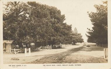
Photograph - Post Card, Early 1900's
One of 17 photographs donated by Olive BlameySepia postcard of the Beach Road with fence and trees on the left and trees on the right."The Rose Series, P. 674" "The Beach Road, Cowes, Phillip Island, Victoria" Letter on back to Lois from Auntie Alicebeach road, cowes phillip island, phillip island, olive blamey -
 Lakes Entrance Historical Society
Photograph - Evatt Park Lakes Entrance Victoria 1982, 1982
trees planted in Evatt Park to commemorate the birth of Prince William enclosed by treated pine tree guards, fire brigade running track glimpsed through trees Lakes Entrance Victoria. 1982. Also a colour photograph of commemorative plaque on sandstone rock near trees 04296.1 size 10 x 15 cmColour photograph of trees planted in Evatt Park to commemorate the birth of Prince William enclosed by treated pine tree guards, fire brigade running track glimpsed through trees Lakes Entrance Victoria 1982 township, parks, gardens -
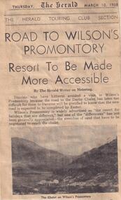 Phillip Island and District Historical Society Inc.
Newspaper clippings, 10/03/1938
Article describing access to Darby Chalet on Wilson's Promontory and the improvement of this with the new road.Article on road to Wilson's Promontory.local history, documents, newspapers, wilson's promontory, darby chalet, black & white newspaper clipping -
 Bendigo Historical Society Inc.
Photograph - BLACK AND WHITE PHOTGRAPH OF NEW HARRROWER
Black and white photograph new harrower for greyhound track. Corey Hiscock, Track curator.clubs and associations, sport, greyhound racing -
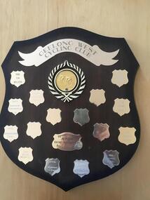 Geelong Cycling Club
Shield
This shield records the junior cyclists who were high achievers in the Geelong region during this period.Indicates the boom time experienced for Junior Cyclists at the Geelong Cycling Club during the late 1990s and early 2000.A mahogany coloured wooden shield with brass plated plaques containing inscriptions of winners of the Junior Track Aggregate races during the years 1997-2007. There is an emblem of a cyclist and a banner at the top centre of the shield. "Geelong West Cycling Club/Junior Track Aggregate/Sponsored by F & S Newton/1997/Ryan Moody/1998/Tim Buckley/1999/Renee Hoppen/2000/Daniel Hudgell/2001/Matt Pope/2002/Chesney Milne/2003/Josh Beer/2004 Mitchell Elmer/2005/Leigh Howard"geelong west cycling club; junior track aggregate; sponsored by f & s newton; ryan moody; tim buckley; renee hoppen; daniel hudgell; matt pope; chesney milne; josh beer; mitchell elme; leigh howard; -
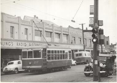 Melbourne Tram Museum
Photograph - Black & White Photograph/s, CLC, early 1950's?
Photograph, Black and White, Birney No. 217 on the Russell St route, Footscray in Barkly St , Cnr Commercial road, just to the west of Geelong Road. Note the tram and bus stop signs on the pole with the traffic lights, and the bus in front of the tram. One of the buildings has an "Ealing's radio electrical sign" Early 1950's?In ink on the rear: "MMTB X217 on Russell Street route at Footscray. / In Barkly St Cnr Commercial Road, immediately west of Geelong Road. / /5" Has KSK number CLC36 in to right hand corner.trams, tramways, footscray, birney, tram stops, bus stops, russell st, barkly st, buses, tram 217 -
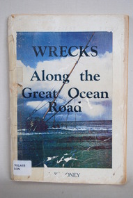 Anglesea and District Historical Society
Book, J Loney, Wrecks Along the Great Ocean Road, 1967
Book first published in 1967 dealing with the shipwrecks along the Great Ocean Road. Illustrated with both maps and photographs and with a chrononolgy of the list of wrecks from pre-1800 through to 1958.Title: WRECKS / Along the / Great Ocean / Road J.K. LONEYjack loney, dewey no 910.453, book -
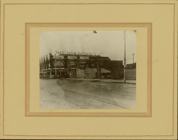 Kew Historical Society Inc
Photograph - Railway level crossing in Glenferrie Road, Glenferrie, E.J. Dower, 1912-13
One of a series of photographs, taken by Edgar James Dower in the second decade of the twentieth century. Born and raised in Olinda, his family later moved to Surrey Hills. He worked as an adult as a clerk in the city office of the Metropolitan Gas Company, and in his role as a 'collector', he was able to photograph scenes including the construction of tramlines and associated buildings in Kew, Hawthorn, Camberwell and Surrey Hills. Later he established a real estate agency with his brother - the E.J. Dower Real Estate Agency, Dandenong Office.The image is an historically significant record of the development of transport infrastructure which was used to connect Victorians in the first two decades of the twentieth century. This development resulted from increases in population and the consequent extension of Melbourne's suburbs. The photographs, both individually and collectively, richly detail the labour of workers and the tools and machinery used to create and extend Melbourne's public transport network in the years preceding and during World War 1.Digital copy of an original mounted photograph showing the old railway crossing in Glenferrie Road, Hawthorn. The removal of the train level crossing and the elevation of the rail line above the road was designed to enable the laying of tram tracks along Glenferrie Road. The buildings to the right of the photo were being demolished to allow for this. "The Don Store" is immediately behind the crossing.Annotated verso: "1912 / Demolishing shops near Glenferrie Railway Station, just prior to the regrading of line to camberwell / Taken by E.J. Dower 1912"theme --- travelling by tram, theme -- connecting victorians by transport and communications, glenferrie railway station, glenferrie road -- hawthorn (vic.), railways -- hawthorn -
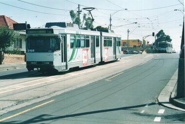 Melbourne Tram Museum
Photograph - Colour Print/s, Colin Rough, 14/03/2003 12:00:00 AM
Colour prints taken by Colin Rough at the North Coburg tram terminus, Sydney Road, 14/3/2003. Tram B2 2105 is waiting on B 2022 to leave. Route 19. Cross street is Bakers Road.On rear in ink various notes about the location and date - 14/3/03, North Coburg Terminus, Sydney Roadtrams, tramways, north coburg, sydney road, route 19, b class, tram 2105, tram 2022 -
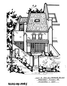 Hawthorn Historical Society
Drawing - Property Illustration, 3/312-316 Barkers Road, Hawthorn
'After training as a Cartographic Draftsman within the mining industry, I worked as a property illustrator for real estate firms in the eastern suburbs of Melbourne for 23 years from 1983. I initially photographed houses with a Polaroid camera and made a 'thumbnail' sketch while there. The photos were used to scale off a sketch in pencil and then that sketch was overlaid with drafting film and the 'pen and ink' completed. The pens I used were the Rotring ‘Rapidigraph’ drafting pens. The ink was also made by Rotring (German).The film was ‘Rapidraw’, polyester drafting film, double matte. It takes a very fine line and doesn’t bleed. As well as house sketches, there were often floor plans and site plans ordered. Aerial sketches were ordered when the property needed an overall view.' (Margaret Picken, 2020)This property illustration is one of a series created by Margaret Picken for a range of real estate agents in Melbourne between c. 1983 and c. 2006. Each work is signed and dated by the artist.Gift of Margaret Picken, 2020Pen and ink property illustration on drafting film of 3/312-316 Barkers Road, Hawthorn by Margaret Picken.Unit 3/312-316 Barkers Road, Haw, Margaret Picken '89. Woodards - Kew.artist - margaret picken 1950- -
 Victoria Police Museum
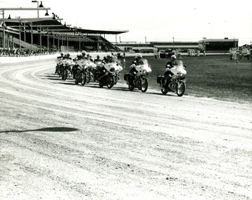
Photograph (police motorcycle)
Hondas and BMWs in exhibition formation at a showgrounds or trotting track. There are grandstands in the background and lights over the track and an equestrian field set up in the centre of the track. Circa 1973police vehicles; motor transport branch; motor transport section; motor cycle patrol; police motorcycles; honda motorcycle; bnmw motorcycle -
 Whitehorse Historical Society Inc.
Photograph - Strip photo/ photocopy, Railway Road Blackburn
East end of Railway Road Blackburn August 1996.Railway Road East end Blackburnrailway road, blackburn, 1976 -
 Whitehorse Historical Society Inc.
Map, Nunawading Road District, 01/04/1863
Plan of proposed new road - April 1863 & estimated expenses.Plan of proposed new road - April 1863 & estimated expenses. Scale 20 chains per inch. Proclaimed Roads 149.Plan of proposed new road - April 1863 & estimated expenses.nunawading road district, roads and streets -
Glenelg Shire Council Cultural Collection
Photograph - Photo card - Panorama of the Harbour, Portland, 1930s
Owned by James and Ada Brimblecombe, Heywood. Later owned by Merle Lewis.Black and white photographic image of a harbour with two long piers running into it and a shorter jetty protruding from it. In the foreground are trees, a dirt road to the right and a railway track visible between the trees.Front: PANORAMA OF THE HARBOUR, PORTLAND (printed, lower centre) -
Lakes Entrance Historical Society
Photograph - Foleys Motor Coaches, 1920 c
Sepia toned photograph showing Foleys motor coaches on road to Lakes Entrance possibly near Bennetts Brook, coach and trailer in front A Ford and trailer behind, tall trees on either side of road, telephone poles on right side. East Gippsland VictoriaFoleys motor coaches on the road to Lakes Entrance c 1920 Courtesy East Gippsland Historical Societytransport -
 Geelong Cycling Club
Road Bike, 1929
Track cycle won by Jack Phillips 1929 in the Melbourne - Ballarat - Geelong - Melbourne Road Race. This was the first open road race won by a Geelong Amateur Cyclist. The Amateur Cycling Club was formed in 1929. This bike was restored by Ken Dickie who did his apprenticeship in fine line restorations and the painting was by Fred Cook. Hand grips by Harry Clarke. They used photographs from Jack Phillips of the original bike to restore the bike to its original colours and appearance.Track cycle one by Jack Phillips - the first of the big open road races won by an amateur.Restored Malvern Start Road Bike from 1929. Painted in red with the words Malvern Star highlighted in white on a blue background on the frame. The stem features two silver stars on a blue background. Single speed with wooden wheel rims. It has a leather saddle and rubber hand grips (formerly used as gas masks in WWI)"Malvern Star"jack phillips; geelong amateur cycling club; malvern star; geelong cycling club; 1929; -
 City of Kingston
Pamphlet - Colour, Smith, Nicolson Pty. Ltd, Cheltenham Estate, c. 1890
Sales plan for land in the suburb of Cheltenham, bounded by Point Nepean Road and Swinden Avenue, including Evesham Road and Wallingford Street.The developing urban area of Cheltenham within the City of Kingston. This land sale pamphlet illustrates the subdivision of land within the municipality and the changing demographic of the district as new houses are constructed close to infrastructure.Colour pamphlet advertising for private sale Cheltenham Estate. Incorporates a map of the estate bordered by Point Nepean Road and Swinden Avenue, including Evesham Road, and Wallingford Street.Handwritten in red ink on subdivison 45: D / H Handwritten in red ink on subdivision 46: Anderson Handwritten in red ink on subdivisions 88, 87, 77 and 56: K / D Handwritten in red ink on subdivision 86: D / H Handwritten in red ink on subdivision 63 and 62: Hudson Handwritten in red ink on subdivision 59 [indecipherable] Handwritten in red ink on subdivision 58: aB Handwritten in red ink on subdivision 57: Lavosh Handwritten in grey pencil on subdivision 28, 26, 24, 67, 58, 49: B Handwritten in grey pencil on subdivisions 78 and 79: Paint Handwritten in purple pencil on subdivsion 114 and 86: B land sales, estate, cheltenham -
Glenelg Shire Council Cultural Collection
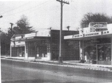
Photograph - Photograph - Road Making, n.d
Port of Portland Authority ArchivesBack: PHT purple stamp. '2/28 252 1.6.54 Breakwater Access Road Re-alignmentport of portland archives, battery point -
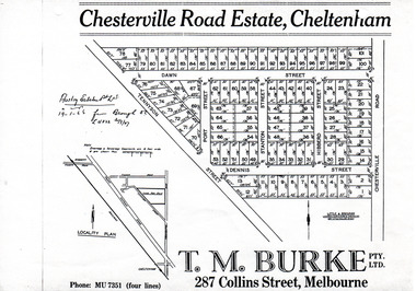 City of Moorabbin Historical Society (Operating the Box Cottage Museum)
Flyer - Chesterville Road Estate, Cheltenham, 1947
Chesterville Road Estate, consisting of 101 building lots, was sold by private sale in late 1947.Example of the progress of the Municipality of MoorabbinPhotocopy of advertising flyer for sale of real estate sales - plan of building blocks for saleChesterville Road Estate, Cheltenham - plan of subdivisiontennyson street, port street, dennis street, station street, dawn street, hubbard street, chesterville road, cheltenham, real estate, auction -
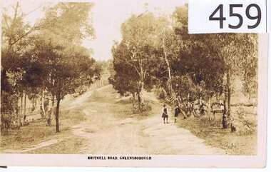 Greensborough Historical Society
Postcard, The Rose Stereographs, Britnell Road, Greensborough, 1920s
This postcard shows us what Britnells Road (now Mountainview Road) looked like in the WW1 era. Britnell Road is a former name of the Mountain View Road section between St Helena Rd and Sherbourne Rodd.A sepia toned postcard featuring a photograph of a rural road scene.2 photo mount remains on rear, nil on front.britnell road, greensborough, mountain view road. -
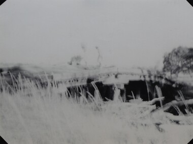 Stawell Historical Society Inc
Photograph, Harris Bridge – Red Bend Road -- Great Western
Harris Bridge – Red Bend Road Great Western.Black & white photo of Bridge. Photo is out of focus so hard to work out.Harris' Bridge Red bend Road Great Westernstawell -
Whitehorse Historical Society Inc.
Map, Burwood Road, Box Hill City, 15/02/1952 12:00:00 AM
Plan of subdivision of 19 blocks in Burwood Road, Burwood.Plan of subdivision of 19 blocks in Burwood Road, Burwood between Greenwood Street and Middleborough Road. Marked as Survey Plan No 5442.Plan of subdivision of 19 blocks in Burwood Road, Burwood. land subdivision, burwood road, burwood, greenwood street, burwood, middleborough road, burwood -
 Victorian Aboriginal Corporation for Languages
Audio CD, Music recorded at Gerard Mission, Cummeragunja, Barmah and Deniliquin, 1963
Songs performed by Annie Mason, Cyril Gerard and Cyril Lindsay at Gerard Mission; Sophie and Coral Briggs at Cummeragunja; Aaron Briggs at Barmah; Ralph Day and Dennis Atkinson at Deniliquin.CD, recording notes (for tracks 00191a and 00191b)gerard mission, cummeragunja, barmah, deniliquin, annie mason, cyril gerard, cyril lindsay, sophie briggs, coral briggs, aaron briggs, ralph day, dennis atkinson