Showing 4459 items
matching walling
-
 Bendigo Historical Society Inc.
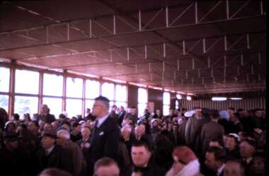
Slide - DAVID MCDONALD COLLECTION: EPPALOCK. CONSTRUCTION, c1960
Eppalock. Construction. Many people attended the opening, men in suit attire. Markings: Eppalock Dam opening of scheme. Inside wall. 1960.Kodakcivil engineering, water supply, eppalock -
 National Vietnam Veterans Museum (NVVM)
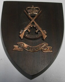
Plaque
Wall plaque on shield shaped wood with two rifles crossed over Victoria and top Crown in brass. 6th Battalion on ribbon in brass.plaque, 6th battalion -
 Buninyong & District Historical Society
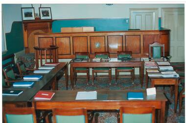
Photograph - Original Photograph, Mr. C.J. Brooks, Interior, central view South wall and bench of 1886 Buninyong Courthouse. Tables and chairs configured as for Buninyong Shire Council, November 1995
Social/ political, legalColour photo, Interior, central view South wall and bench of 1886 Buninyong Courthouse. Tables and chairs configured as for Buninyong Shire Council.buninyong, courthouse, buninyong council chamber -
 Tatura Irrigation & Wartime Camps Museum
Photograph, Alan Whiting, 1924
Taken for the Victorian State Rivers and Water Supply Commission.Mounted medium sized black and white photograph. Waranga Basin / Workmen pouring concrete for cutoff wall scaffolding across middle pictureirrigation, victorian state rivers and water supply commission, waranga basin -
Tatura Irrigation & Wartime Camps Museum
Photograph, Cattanach Canal, 1957
Taken by the photographer for Victoria State Rivers and Water Supply Commission.Large sepia photograph - water filled channel inlet and bank - Man standing on platform looking down on concrete wall of measuring weir.Above photo: "Cattanach Canal / Inlet and Measuring Weir to Waranga Basin."irrigation, victoria state rivers and water supply commission, cattanach canal -
Tatura Irrigation & Wartime Camps Museum
Model - Farm building, 1940
Made by internee camp 3 tatura used as part of a farm scen by childrenModel of a farm building, roof painted dark red, interior green, both decorated , trees, overall backgroun, walls flesh colour.tatura, toys, general -
 Robin Boyd Foundation
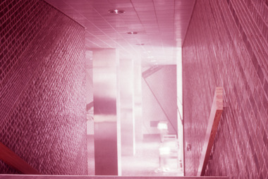
Slide, Robin Boyd, 1961
Robin Boyd wrote two books on Japanese architects and architecture - “Kenzo Tange” published by George Braziller in 1962 and “New Directions in Japanese Architecture” published by Studio Vista in 1968. During the 1960s he travelled several times to Japan to research these books and as part of his role as Exhibits Architect for the Australian Pavilion at Expo ‘70 in Osaka. Colour slide in a mount. Interior (staircase and tiled walls), Okayama Prefectural Government Building, Okayama, Japan, 1957. (Architect: Kunio Maekawa.)Made in Australia / 7slide, robin boyd, japan -
 National Trust of Australia (Victoria)
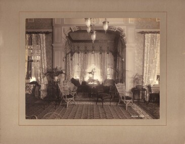
Photograph, Drawing room, c1903
Black and white photograph mounted on light grey coloured card. Photograph shows Sargood's Sitting Room taken from the East wall.Stamped onto front left bottom corner of photograph: 'Johnstone & O'Shannessy/ & Co./ Propy. Ltd/ Collins St. Melb.' Written on photograph: 'SITTING ROOM' sargood family, rippon lea -
Whitehorse Historical Society Inc.
Newspaper, A Mural Full of History, 17/04/1996 12:00:00 AM
Team of young Artists will depict Historical Mural on front wall of Blackburn Library, sponsored by Landcare & Environment Action Group, funded by DEET.Team of young Artists will depict Historical Mural on front wall of Blackburn Library, sponsored by Landcare & Environment Action Group, funded by DEET.Team of young Artists will depict Historical Mural on front wall of Blackburn Library, sponsored by Landcare & Environment Action Group, funded by DEET.public libraries, blackburn branch library, landcare & environment action group, australia. department of employment, education and training -
 Ballarat Heritage Services
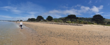
Photograph, Clare Gervasoni, Apollo Bay, Victoria, 24/01/2022
In 2021, the Department of Environment, Land, Water and Planning (DELWP) constructed two new groynes and a section of rock seawall at Apollo Bay to help manage the impacts of coastal erosion. The new 70-meter-long rock groynes run perpendicular to the shoreline and be located just south of the Milford St revetment and to the south of Milford Creek. Sections of rock seawall will be constructed between the two Groynes with an aim to protect the dune, walking path, cypress trees and road from erosion. Colour photograph of a coastal scene at Apollo Bay, featuring new rock wall and groynes to protect the Great Ocean Road from erosion. apollo bay, beach, coast, groyne, rockwall -
 Ballarat Heritage Services
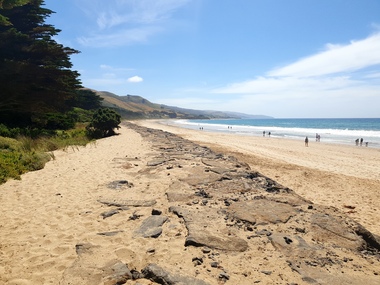
Photograph, Clare Gervasoni, Sea Wall at Apollo Bay, Victoria, 24/01/2022
In 2021, the Department of Environment, Land, Water and Planning (DELWP) constructed two new groynes and a section of rock seawall at Apollo Bay to help manage the impacts of coastal erosion. The new 70-meter-long rock groynes run perpendicular to the shoreline and be located just south of the Milford St revetment and to the south of Milford Creek. Sections of rock seawall will be constructed between the two Groynes with an aim to protect the dune, walking path, cypress trees and road from erosion. Colour photograph of a coastal scene at Apollo Bay, featuring new rock wall and groynes to protect the Great Ocean Road from erosion. apollo bay, beach, coast, groyne, rockwall, sea wall -
 Ballarat Heritage Services
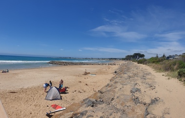
Photograph, Clare Gervasoni, Sea Wall at Apollo Bay, Victoria, 24/01/2022
In 2021, the Department of Environment, Land, Water and Planning (DELWP) constructed two new groynes and a section of rock seawall at Apollo Bay to help manage the impacts of coastal erosion. The new 70-meter-long rock groynes run perpendicular to the shoreline and be located just south of the Milford St revetment and to the south of Milford Creek. Sections of rock seawall will be constructed between the two Groynes with an aim to protect the dune, walking path, cypress trees and road from erosion. Colour photograph of a coastal scene at Apollo Bay, featuring new rock wall and groynes to protect the Great Ocean Road from erosion. apollo bay, beach, coast, groyne, rockwall, sea wall -
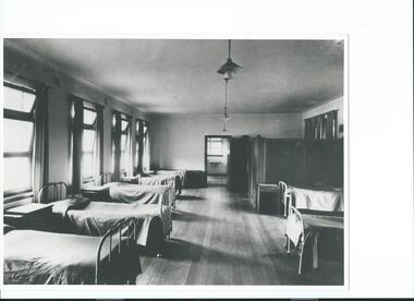 St Matthews/Wiseman House Archive
Photograph, St Agnes Girls Home, Lambie Cottage, c.1950s
Lambie Cottage was an addition to St. Agnes Girls' Home, providing more modern accommodation.Development of St Agnes Girls' Home to accommodate additional children in a more modern setting.A b&w photograph of large room with single beds lined up along each wall, bathroom at the end of the room, timber floor.Copied with permission -
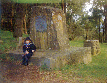 Mt Dandenong & District Historical Society Inc.
Photograph, The Peace Memorial FiveWays, Kalorama c1994, c1994
Constructed from a single piece of local stone. Ellis Park in background. Child seated is Victoria Wall about 5 years old.fiveways, ellis park, peace memorial -
Southern Sherbrooke Historical Society Inc.
Information folder - Wall family
Information folder containing items pertaining to the Wall family of Menzies Creek. Contents: -article, "The miracle that was Bessie", The Mail, 27th January 2004bessie wall, wall family, menzies creek, st cuthberts church, mr & mrs percy douglas, norma marshall -
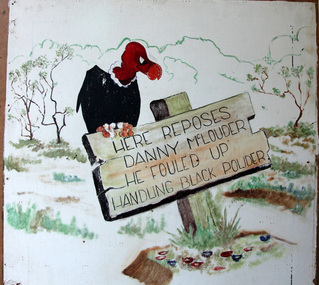 Australian Army Museum of Western Australia
Grafitti
No documentation available.Wall panel retrieved from Midland ammunition deport. "Here reposes Danny McLouder. He fouled up handling black powder" -
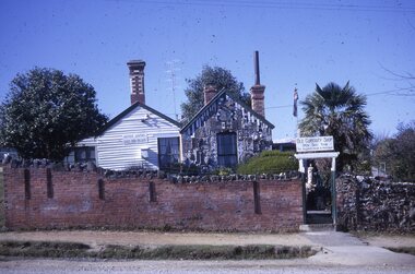 Ballarat Tramway Museum
Slide - 35mm slide/s, Les Fordham, Aug. 1967
Kodachrome white cardboard mount 35mm slides - dated August 1967 taken by Les Fordham of the Old Curiosity Shop side and wall.tramways, trams, curiosity shop, tourism -
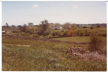 Buninyong & District Historical Society
Photograph - Original Photograph, View from Lal Lal St. 1982, 1982
Colour photograph, view from Lal Lal St. looking west in1982, drystone wall runs across, catholic church in backgroundbuninyong, lal lal street, drystone wall, catholic church, landscape -
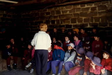 Sunbury Family History and Heritage Society Inc.
Photograph, School Excursion, cEarly 1990s
The students from Bulla Primary School were taken to one of the farms in the local area to introduce them farm life.A non-digital coloured photograph of a group of children sitting on hay bales in a dingy farm building with bluestone walls. A lady is supervising the children.school excursions, bulla primary schooil, farms -
 University of Melbourne, Burnley Campus Archives
Photograph - Black and white print, Information Branch Victorian Department of Agriculture, Student Year Group, Unknown
2 copies black and white photograph. Group photograph of students seated on chairs in front of a wall. Year not identified. What they represent not identified.On reverse, "Photograph by Information Branch Victorian Department Of Agriculture Ref. No. D.1441?.A."students, student group. -
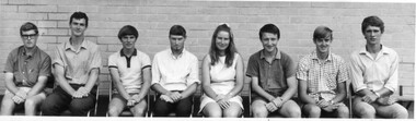
 St Patrick's Old Collegians Association (SPOCA)
Photograph - Students, 1930s
-
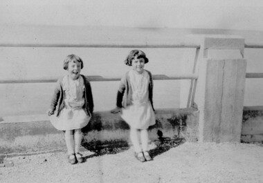 Linton and District Historical Society Inc
Photograph, Reilly Twins at the Seaside, circa 1925, 1925
Part of photograph album donated by Mrs Faull. Mr Reilly was Grenville Shire Engineer 1923-1930 Girls approximately 8 years old on a day at the seaside.Sepia photograph of two young girls wearing short summer dresses and cardigans sitting beside each other on low wall at seaside.reilly twins, faull collection -
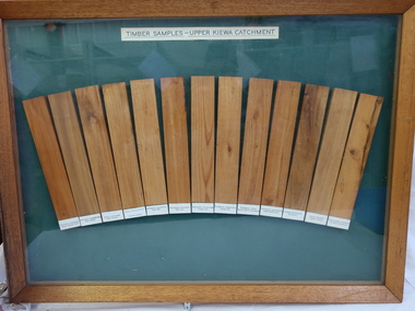 Kiewa Valley Historical Society
Timber Samples - Upper Kiewa Catchment
13 strips of wood showing their different colour and grain and representing trees found in the Kiewa Catchment.A record of timber found in the Upper Kiewa Catchment13 different types of wood displayed in a wooden framed picture/wall hanging. Each wood is labelled. Green background and wooden frame.Labelled: Timber Samples - Upper Kiewa Catchmenttimber samples, upper kiewa catchment -
Bendigo Historical Society Inc.
Photograph - AUSTIN COLLECTION: Central Deborah Gold Mine, Possibly 1990's
Central Deborah Gold Mine history: At its peak, Central Deborah Gold Mine reached a depth of 412 metres. It has 17 separate levels and 15 kilometres of drives and cross cuts (tunnels). The Central Deborah was very much a hands-on mine and the conditions that the miners worked in would be considered shocking by today's standards – being lowered underground in a cage with only two sides, often working ankle to knee deep in water, filling up to 32 ore trucks a shift by hand which were then pushed a mile or more along rails in the drives, working by carbide lamp, breathing in the fumes and rock dust and communication by bells. Geez, they were ironmen. However, at the time working conditions were considered to be among the best on the goldfields at Central Deborah, after all it was one of the only mines that had hot showers. Following Central Deborah Gold Mine's closure, the Bendigo skyline began to noticeably change. Obvious remnants of mining such as poppet heads, engine rooms, service quarters, battery houses and chimneys were steadily disappearing. After intense lobbying by the local community, the Bendigo City Council purchased the still very much intact Central Deborah Gold Mine in 1970 for a mere $6,000 to ensure that a vital link to Bendigo's historic golden past was maintained. The Bendigo Trust was then formed to oversee the operations of the Central Deborah Gold Mine, which led to the surface of the mine being opened to the public in 1971. Initially the surface was open for just 12 hours a week and as the demand for viewing a part of Bendigo's history increased, so did the opening hours. In 1974 the mine was gazetted as a Public Historical Purposes Reserve and attracted such visitors as H.R.H Prince Charles. By far the greatest shortcoming at this stage was that no one could view the underground workings, as these had become flooded. After what could only be described as a monumental effort by everyone involved, Level 2 of the mine was officially opened to the public by the Premier of Victoria, the Honourable John Cain, on 20 June 1986, which brought to fruition a long standing dream.Black and white photograph. Two men with hard hats and lights, inspecting quartz outcrop on wall of drive at Central Deborah Gold Mine.gold mining, central deborah gold mine, ray beer, mine manager -
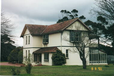 Sunbury Family History and Heritage Society Inc.
Photograph, Veronica Burgess, Ardcloney House, 8th September 2001
This is a more recent photograph than entry P0854.The two storey house was built for Dr.William Faulkner in 1911. It is opposite the intersection of Evans and Macedon Streets. As well as the house, a garage was also built for the doctor's car, along with smaller building for the chauffeur. Dr. Faulkner was one of the first people in Sunbury to own a car. Doctor Faulkner lived at Ardcloney until he died in 1922. Over the years it had other owners and in the early 2000s, it was taken over by the State government and is now a day-care hospital. Other buildings have been built on the site but the original house is the Administration Section.A coloured photograph of two storey home with white stucco walls and red tiled roof. The house is set in large garden with lawn and trees.ardcloney house, dr. william faulkner -
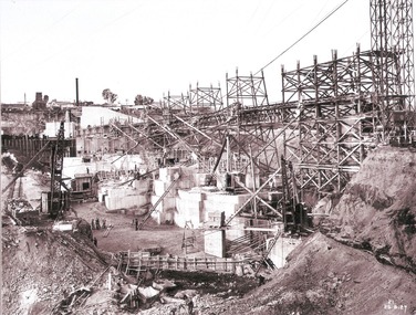 Wodonga & District Historical Society Inc
Album - Hume Reservoir Australia Album - Work proceeding inside the coffer dam (2), August 1927
This set of photos is from a leather bound album bearing the inscription "HUME RESERVOIR AUSTRALIA" plus 'The Rt. Hon. L. C. M. S. Amery, P. C., M .P.' all inscribed in gold. It was presented to The Rt. Hon. L. C. M. S. Amery, P. C., M. P, Secretary of State for Dominion Affairs on the occasion of his visit to the Hume Reservoir on 2nd November 1927. This album is of local and national significance as it documents the planning and development of the Hume Reservoir up to 1927. It was the largest water reservoir in the British Empire. The album records the pioneering engineering work that went into its construction.DEPARTMENT OF PUBLIC WORKS, N.S.W. RIVER MURRAY WATERS SCHEME. HUME RESERVOIR. 26. Work proceeding inside the coffer dam. This view was taken from the edge of the cut for the South Wing Wall foundations looking from the opposite direction to that of the preceding photograph, the curving downstream face of the main wall being seen beyond the steam navvy. This view shows the way in which the concrete paddocks are stepped and broken jointed vertically and horizontally. In the distance is the North Wing Wall and Power House stack beyond it. New South Wales, August 1927.hume reservoir australia, river murray waters scheme, hume reservoir construction -
Glenelg Shire Council Cultural Collection
Container - Tin, n.d
Displayed in History House (Cabinet, South wall)Green tin with lid. Pictures on front.domestic item, kitchen, food container, tin -
 Glenelg Shire Council Cultural Collection
Domestic object - Drinking Glass, n.d
Displayed in History House (Cabinet, South wall)Blue glass with gold and white hand-painted floral pattern.domestic, drinking, food and drink -
 Glenelg Shire Council Cultural Collection
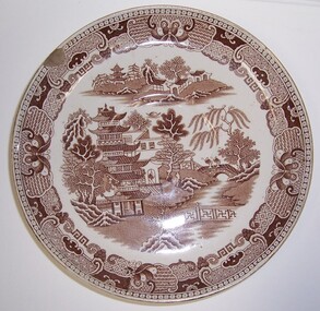
Domestic object - Plate - "Willow pattern plate", n.d
Displayed in History House (Cabinet, South wall)Willow-pattern plate with brown design.Front: Base: Willow/AF & S (brown print, centre) -
 Eltham District Historical Society Inc
Photograph, The Pavilion, Eltham Living and Learning Centre, September 1994, 1994
Note: no garden retaining wall and no stairs to verandah Colour photographeltham, eltham living and learning centre, living and learning centre, pavilion, shire of eltham