Showing 1627 items matching "yarra river"
-
 Port Melbourne Historical & Preservation Society
Photograph - Dismantled cranes one the edge of the Yarra, Ron Laing, Sep 2000
... laying in the old pile yard on the edge of the River Yarra, where... of the River Yarra, where they were 'stored' after removal from Station ...Colour photograph of the two dismantled 3 ton cargo cranes laying in the old pile yard on the edge of the River Yarra, where they were 'stored' after removal from Station Pierpiers and wharves, demolitions, glen stuart -
 Greensborough Historical Society
Article - Article, Journal, E. G. Ritchie, Melbourne's water supply undertaking, by E. G. Ritchie, 1934
... water supply, including the Yarra and Plenty Rivers and Yan Yean... of the development of Melbourne's water supply, including the Yarra ...An historical account of the development of Melbourne's water supply, including the Yarra and Plenty Rivers and Yan Yean and Maroondah Reservoirs.4 p., photocopy of article.melbourne water, mmbw, maroondah aqueduct, yan yean reservoir -
 Eltham District Historical Society Inc
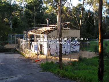
Photograph, Fay Bridge, Warrandyte cool store, 9 September 2019
... which sits on the Yarra River flood plain. In 2017, through... which sits on the Yarra River flood plain. In 2017, through ...Remains of the old Warrandyte Dairy — Originally constructed to store milk for delivery from Mapleoak Dairies, delivered by the Bellinger family, up until the early 1970s. The Warrandyte Dairy closed in 1987 before the land and building was purchased by Melbourne Water in 1988 to reduce flood risk to the community and preserve riverside land from development on the site which sits on the Yarra River flood plain. In 2017, through a partnership with Manningham City Council, Warrandyte Historical Society and the Warrandyte Community Association, Melbourne Water renovated the 73-year-old site and installed interpretive signs detailing its history for the community.2019-09-09, fay bridge collection, warrandyte cool store, warrandyte dairy -
 Kew Historical Society Inc
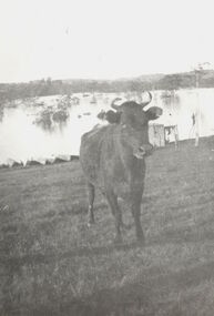
Photograph, Cattle in North Kew floods, 1934
... The year 1934 witnessed the greatest flooding of the Yarra... The year 1934 witnessed the greatest flooding of the Yarra River ...The year 1934 witnessed the greatest flooding of the Yarra River since settlement. This work forms part of the collection assembled by the historian Dorothy Rogers, that was donated to the Kew Historical Society by her son John Rogers in 2015. The manuscripts, photographs, maps, and documents were sourced by her from both family and local collections or produced as references for her print publications. Many were directly used by Rogers in writing ‘Lovely Old Homes of Kew’ (1961) and 'A History of Kew' (1973), or the numerous articles on local history that she produced for suburban newspapers. Most of the photographs in the collection include detailed annotations in her hand. The Rogers Collection provides a comprehensive insight into the working habits of a historian in the 1960s and 1970s. Together it forms the largest privately-donated collection within the archives of the Kew Historical Society.Photograph of floodwaters encroaching on farm land in North Kew in the flood of 1934.Nth. Kew. 1934 Floodsfloods (melbourne) 1934, dorothy rogers -
 Eltham District Historical Society Inc
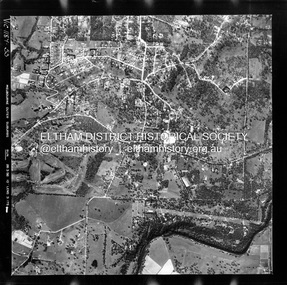
Photograph - Aerial Photograph, Landata, Montmorency / Lower Plenty, Feb. 1956
... by Rattray Road to north, Yarra River to south, Bolton Street to east... by Rattray Road to north, Yarra River to south, Bolton Street to east ...Centred on 20 Panorama Avenue, Lower Plenty bounded by Rattray Road to north, Yarra River to south, Bolton Street to east and Heidelberg Golf Club to west. Historic Aerial Imagery Source: Landata.vic.gov.au Aerial Photo Details: Project No : 250 Project : MELBOURNE OUTER SUBURBS PROJECT Run : 16A Frame : 53 Date : 02/1956 Film Type : B/W Camera : EAG9 Flying Height : 10000 Scale : 12000 Film Number : 1187 GDA2020 : 37°43'47"S, 145°07'25"E MGA2020 : 334645, 5822519 (55) Melways : 21 D9 (ed. 42)aerial photo, lower plenty, main road, montmorency, phoebe mason collection, bolton steet, heidelberg golf club, rattray road -
Kew Historical Society Inc
Booklet - Old Kew Golf Links Estate, 1926
... of the Yarra River. ... resulted in changing the course of a section of the Yarra River ...Subdivision plans and real estate flyers/brochures reveal a number of aspects of urban development and history. The Kew Historical Society's collection of these plans, as well as advertisements extracted from magazines, cover key aspects of community development and architectural history of Kew and Kew Eat as well as surrounding suburbs. While most of the plans in the collection were gifted to the Society by the former City of Kew, a number of other plans and advertisements have been donated by individuals, of which this is an example.8-page brochure advertising 80 residential home sites for sale in a subdivision called the 'Old Kew Golf Links Estate'. These sites had historic importance in Kew's history as they had previously belonged to Kodak Pty Ltd who were refused permission by Kew Council to use the land for industrial development. The estate, advertised was advertised as being within five miles of Melbourne. The brochure is notable as it includes photographs of Kew East Primary School, the former Kew Golf Club clubhouse, and 'The Moorings' Boathouse (aka Chipperfield's Boat House). The aerial photograph, overlaid with names of notable sites, on the final page is of interest as it shows the area before the intrusion of the Eastern Freeway, which resulted in changing the course of a section of the Yarra River. old kew golf links estate, subdivision -- kew (vic.), subdivisions -- kew east (vic), chipperfield's boathouse, kew east primary school, kew golf club -
 Kew Historical Society Inc
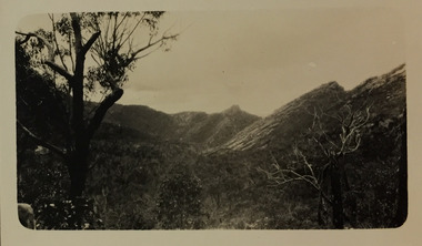
Photograph - Grampians, 1924
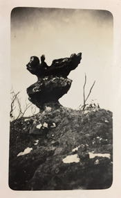
... the Yarra River at Studley Park and at Kew. The remainder... pages in the album document the Yarra River at Studley Park ...Henry Beater Christian (1886-1962) , was a descendant of one of the earliest settler families in Kew. Employed at the Kew Asylum as a 'public servant', he was a skilled amateur photographer, photographing numerous scenes in Kew and on his travels around Victoria. The majority of his photographs date from 1916 to 1929. His finest photographs are housed in two photograph albums. Digital copy of a photograph from page 12 of the 47-page photograph album containing 261 gelatinous silver images, loaned by Diane Washfold with permission given to digitise and hold a copy in our collection. The first and last pages in the album document the Yarra River at Studley Park and at Kew. The remainder of the album includes photographs of walking and car tours in rural Victoria including 'wilderness' areas in the Grampians, Gippsland and the High Country. Six album pages document a camping trip by Henry Christian to the Grampians in September 1924. The photos include pictures of lookouts, and natural features including rock faces and waterfalls, as well as his camp site. This photo is of a self-standing rock on what is probably the Mt Victory trail. "Mt Victory / Grampians / 9.24"henry beater christian (1886-1962), landscape photography, christian-washfold collection, photograph albums, grampians, mt victory, gariwerd -
 Kew Historical Society Inc
Photograph - Grampians, 1924
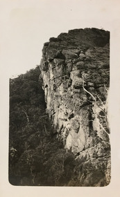
... the Yarra River at Studley Park and at Kew. The remainder... the Yarra River at Studley Park and at Kew. The remainder ...Henry Beater Christian (1886-1962) , was a descendant of one of the earliest settler families in Kew. Employed at the Kew Asylum as a 'public servant', he was a skilled amateur photographer, photographing numerous scenes in Kew and on his travels around Victoria. The majority of his photographs date from 1916 to 1929. His finest photographs are housed in two photograph albums. Digital copy of a photograph from page 13 of the 47-page photograph album containing 261 gelatinous silver images, loaned by Diane Washfold with permission given to digitise and hold a copy in our collection. The first and last pages in the album document the Yarra River at Studley Park and at Kew. The remainder of the album includes photographs of walking and car tours in rural Victoria including 'wilderness' areas in the Grampians, Gippsland and the High Country. Six album pages document a camping trip by Henry Christian to the Grampians in September 1924. The photos include pictures of lookouts, and natural features including rock faces and waterfalls, as well as his camp site. This photo is of one of a well-known cliff face on one of the walking trails. Unitled [Grampians]henry beater christian (1886-1962), landscape photography, christian-washfold collection, photograph albums, grampians, mt victory, gariwerd -
 Kew Historical Society Inc
Photograph - Grampians, 1924
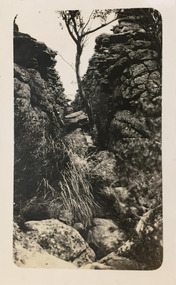
... the Yarra River at Studley Park and at Kew. The remainder... the Yarra River at Studley Park and at Kew. The remainder ...Henry Beater Christian (1886-1962) , was a descendant of one of the earliest settler families in Kew. Employed at the Kew Asylum as a 'public servant', he was a skilled amateur photographer, photographing numerous scenes in Kew and on his travels around Victoria. The majority of his photographs date from 1916 to 1929. His finest photographs are housed in two photograph albums. Digital copy of a photograph from page 13 of the 47-page photograph album containing 261 gelatinous silver images, loaned by Diane Washfold with permission given to digitise and hold a copy in our collection. The first and last pages in the album document the Yarra River at Studley Park and at Kew. The remainder of the album includes photographs of walking and car tours in rural Victoria including 'wilderness' areas in the Grampians, Gippsland and the High Country. Six album pages document a camping trip by Henry Christian to the Grampians in September 1924. The photos include pictures of lookouts, and natural features including rock faces and waterfalls, as well as his camp site. This photo is of one of opposing rock faces on one of the walking trails. Unitled [Grampians]henry beater christian (1886-1962), landscape photography, christian-washfold collection, photograph albums, grampians, gariwerd -
 Kew Historical Society Inc
Photograph - Grampians, 1924
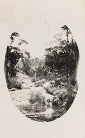
... the Yarra River at Studley Park and at Kew. The remainder... collection. The first and last pages in the album document the Yarra ...Henry Beater Christian (1886-1962) , was a descendant of one of the earliest settler families in Kew. Employed at the Kew Asylum as a 'public servant', he was a skilled amateur photographer, photographing numerous scenes in Kew and on his travels around Victoria. The majority of his photographs date from 1916 to 1929. His finest photographs are housed in two photograph albums. Digital copy of a photograph from page 14 of the 47-page photograph album containing 261 gelatinous silver images, loaned by Diane Washfold with permission given to digitise and hold a copy in our collection. The first and last pages in the album document the Yarra River at Studley Park and at Kew. The remainder of the album includes photographs of walking and car tours in rural Victoria including 'wilderness' areas in the Grampians, Gippsland and the High Country. Six album pages document a camping trip by Henry Christian to the Grampians in September 1924. The photos include pictures of lookouts, and natural features including rock faces and waterfalls, as well as his camp site. This photo is of a rock pool, developed within an oval framing device."Grampians"henry beater christian (1886-1962), landscape photography, christian-washfold collection, photograph albums, grampians, gariwerd -
 Kew Historical Society Inc
Photograph - Grampians, 1924
... the Yarra River at Studley Park and at Kew. The remainder... collection. The first and last pages in the album document the Yarra ...Henry Beater Christian (1886-1962) , was a descendant of one of the earliest settler families in Kew. Employed at the Kew Asylum as a 'public servant', he was a skilled amateur photographer, photographing numerous scenes in Kew and on his travels around Victoria. The majority of his photographs date from 1916 to 1929. His finest photographs are housed in two photograph albums. Digital copy of a photograph from page 15 of the 47-page photograph album containing 261 gelatinous silver images, loaned by Diane Washfold with permission given to digitise and hold a copy in our collection. The first and last pages in the album document the Yarra River at Studley Park and at Kew. The remainder of the album includes photographs of walking and car tours in rural Victoria including 'wilderness' areas in the Grampians, Gippsland and the High Country. Six album pages document a camping trip by Henry Christian to the Grampians in September 1924. The photos include pictures of lookouts, and natural features including rock faces and waterfalls, as well as his camp site. This is a photo of local flora on a bushland track in the Grampians, developed within an oval frame."Grampians"henry beater christian (1886-1962), landscape photography, christian-washfold collection, photograph albums, grampians, gariwerd -
 Kew Historical Society Inc
Photograph - Grampians, 1924
... the Yarra River at Studley Park and at Kew. The remainder... the Yarra River at Studley Park and at Kew. The remainder ...Henry Beater Christian (1886-1962) , was a descendant of one of the earliest settler families in Kew. Employed at the Kew Asylum as a 'public servant', he was a skilled amateur photographer, photographing numerous scenes in Kew and on his travels around Victoria. The majority of his photographs date from 1916 to 1929. His finest photographs are housed in two photograph albums. Digital copy of a photograph from page 15 of the 47-page photograph album containing 261 gelatinous silver images, loaned by Diane Washfold with permission given to digitise and hold a copy in our collection. The first and last pages in the album document the Yarra River at Studley Park and at Kew. The remainder of the album includes photographs of walking and car tours in rural Victoria including 'wilderness' areas in the Grampians, Gippsland and the High Country. Six album pages document a camping trip by Henry Christian to the Grampians in September 1924. The photos include pictures of lookouts, and natural features including rock faces and waterfalls, as well as his camp site. This photo is a long distance view of the mountains with trees framing the picture in the foreground. "Grampians"henry beater christian (1886-1962), landscape photography, christian-washfold collection, photograph albums, grampians, mt victory, gariwerd -
 University of Melbourne, Burnley Campus Archives
Photograph - Black and white print, Children Playing in the River, Unknown
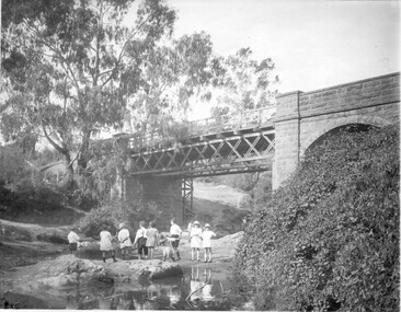
... in the river (Yarra?) with a bridge above them. T H Kneen suggests...children rocks river bridge yarra Hawthorn railway Black ...Black and white photograph. Children standing on rocks in the river (Yarra?) with a bridge above them. T H Kneen suggests it is the Melbourne Hawthorn Railway Bridge and that The Boulevard now passes under the arch.children, rocks, river, bridge, yarra, hawthorn railway -
 Flagstaff Hill Maritime Museum and Village
Decorative object - Pen Tray, David Hay, circa 1847
... . It incorrectly states that the vessel "was the first boat up the river..." first boat / up river Yarra with / Fawkner later wrecked... river Yarra with / Fawkner later wrecked / at Warrnambool Vic ...This pen tray is handmade from some of the timbers from the wreck of the schooner Enterprise. It was originally donated to the former Warrnambool Museum and Art Gallery and transferred to Flagstaff Hill Maritime Museum and Village when it was first established. The inscription on the rear was added at a later date. It incorrectly states that the vessel "was the first boat up the river Yarra with Fawkner", confusing this Warrnambool wreck "Enterprise" with Fawkner's vessel "Enterprize" (sometimes written "Enterprise"). THE “ENTERPRISE” 1847-1850 The wooden, two-masted schooner Enterprise was built in New Zealand in 1847 and registered in Melbourne, Australia. The Enterprise carried cargoes of agricultural produce and other commodities for trade between the ports of the Colony. On September 14, 1850, the Enterprise was at anchor in Lady Bay under its Master, James Gardiner Caughtt, loaded with a cargo of wheat and potatoes. A strong south-easterly wind caused the vessel to drag on its only anchor, and the rudder was lost. The gale-force wind blew it sideways, and it became grounded. A local indigenous man, Buckawall, braved the rough sea to take a line from the shore to the Enterprise. All five members of the crew were able to make it safely to land. The Enterprise was wrecked. The Enterprise wreck was in an area called Tramway Jetty in Lady Bay. Since then, the area became the location of the Lady Bay Hotel, and now, in 2019, it is in the grounds of the Deep Blue Apartments. In fact, with the constantly changing coastline through built-up sand, the wreck site is now apparently under the No. 2 Caravan Park on Pertobe Road, perhaps 150 metres from the high tide. Its location was found by Ian McKiggan (leader of the various searches in the 1980s for the legendary Mahogany Ship). DIFFERENTIATING the New Zealand Schooner “Enterprise” from John Fawkner’s “Enterprize“ Dr Murray Johns, Melbourne, says in his article The Mahogany Ship Story “… As I documented in 1985, the Warrnambool wreck was of an entirely different ship, also called Enterprize [with the spelling ‘Enterprise’], but built in New Zealand in 1847. Fawkner’s ship had already been sold to Captain Sullivan in 1845 and was wrecked on the Richmond Pier in northern New South Wales early in 1847. “ The pen tray is significant for its association with the wreck of the Enterprise, which is listed on the Victorian Heritage Database, VHR S238. The Enterprise is of significance as a New Zealand-built but Australian-owned coastal trader. The wreck was also significant for its association with the indigenous hero Buckawall, who saved the lives of the five crew on board. The pen tray is an example of the use of timbers salvaged from shipwrecks along the coast.Decorative pen tray; handmade and carved from timber from the vessel "Enterprise", 1847-1850. The tray is made from several pieces of wood and has a concave surface. The engraving includes a border, motifs, and decorative scrolls on the sides. The inscription on the rear was written in script. A paper tag marked 'Swinburne' was with the board."Swinburne", "from the vessel Enterprise" Writing on the back of the pen tray: "Made from / wreck of / "Enterprise" first boat / up river Yarra with / Fawkner later wrecked / at Warrnambool Vic"flagstaff hill, warrnambool, shipwrecked-coast, flagstaff-hill, flagstaff-hill-maritime-museum, maritime-museum, shipwreck-coast, flagstaff-hill-maritime-village, wood carving, carving, carving craft, 1850 wreck, john watson, james gardiner caught, tramway jetty, lady bay, rescue line, ian mckiggan, vhr s238, relic, buckawall, schooner, enterprise, coastal trader, new zealand, indigenous rescue, indigenous hero, pen holder, pen tray, wood souvenir, enterprise s ouvenir -
Mission to Seafarers Victoria
Film - VHS, Flying Angels, 1995
... and shooting of the port, the mission under renovation. Intro: Yarra... and shooting of the port, the mission under renovation. Intro: Yarra ...In the Annual Report 1995: " During the year, a group of young people sponsored by the L.E.A.P. organisations, spent some weeks at the 717 Flinders Street, designing and making a video about the work and life of the Mission." The documentary filmed in VHS, mixes interviews, images from the MTSV collection and shooting of the port, the mission under renovation. Intro: Yarra River Images of the Sherlock Holmes Hotel. Archbishop Rodney Oliver, son of Reverend Padre Oliver, and Chairman of the State Council talks about the history of the Mission. John Phillips, caretaker Joan Leslie, volunteer The film has been transferred onto DVD, USB key and saved on digital form.john rodney oliver, dora simpson nee walker, john phillips, caretaker, joan leslie -
 Eltham District Historical Society Inc
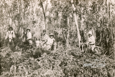
Photograph, Bend of Islands, c.1928
... at a bend of the Yarra River near Watsons Creek. It is located near... at a bend of the Yarra River near Watsons Creek. It is located near ...Bend of Islands is named after a group of small islands at a bend of the Yarra River near Watsons Creek. It is located near the town of Kangaroo Ground. The locationn was a long time favourite spot for locals and visitors to fish and swim in the river. This is one of a series of four photographs that depict a mainly young group of people recreating in the area, particularly enjoying horse riding. Possibly weekend campers. Photos taken about 1926-1928. In 1938 "The Argus" advertised weekend cabins at the Bend of Islands estate 5-are Yarra Yarra frontage in the Christmas Hills Gorge ideal for weekend cabins. "Bathing, fishing, canoeing, shooting may be enjoyed in ideal surroundings". Black and white photograph (reproduction)Bend of Islands, c.1928 bend of islands, horse riding, camping, tent -
 Eltham District Historical Society Inc
Photograph, Bend of Islands
... at a bend of the Yarra River near Watsons Creek. It is located near... at a bend of the Yarra River near Watsons Creek. It is located near ...Bend of Islands is named after a group of small islands at a bend of the Yarra River near Watsons Creek. It is located near the town of Kangaroo Ground. The locationn was a long time favourite spot for locals and visitors to fish and swim in the river. This is one of a series of four photographs that depict a mainly young group of people recreating in the area, particularly enjoying horse riding. Possibly weekend campers. Photos taken about 1926-1928. In 1938 "The Argus" advertised weekend cabins at the Bend of Islands estate 5-are Yarra Yarra frontage in the Christmas Hills Gorge ideal for weekend cabins. "Bathing, fishing, canoeing, shooting may be enjoyed in ideal surroundings". Black and white photograph (reproduction)Bend of Islands bend of islands, camping, tent, horse riding -
 Melbourne Tram Museum
Photograph - Set of 5 Black & White - First AETA tour, 15-2-1947
... building in the background. 5 - Just to the east of Yarra River... to the east of Yarra River Bridge in Swan Street with the Burnley ...Set of five photographs of the first Australian Electric Traction Association (AETA) tram tour of Melbourne on 15/2/1947. See page 8 of the March 1947 issue of "Tram Tracks" for details of the tour and the MMTB Crew. 1 - SW6 881 about to leave Glen Huntly Depot 2 - Crossing Balaclava Junction 3 - Crossing the Kooyong railway level crossing in Glenferrie Road - has the railway signal box and gates in view. 4 - Turning into Riversdale Road from Glenferrie Road with the Stotts Business College building in the background. 5 - Just to the east of Yarra River Bridge in Swan Street with the Burnley Gardens on the right.Yields information about the first AETA tram tour in 1947Set of 5 Black and white photograph on paper. Two copies of each held.Each one of the set has a photographers file stamp on the rear, but no details filled in.trams, tramways, aeta, tram tours, tram 881, sw6 class, glen huntly, kooyong level crossing, glenferrie road, riversdale road, burnley, hawthorn, balaclava junction, glen huntly depot, hawthorn road, swan st -
 Kew Historical Society Inc
Photograph - Grampians, 1924
... the Yarra River at Studley Park and at Kew. The remainder... pages in the album document the Yarra River at Studley Park ...Henry Beater Christian (1886-1962) , was a descendant of one of the earliest settler families in Kew. Employed at the Kew Asylum as a 'public servant', he was a skilled amateur photographer, photographing numerous scenes in Kew and on his travels around Victoria. The majority of his photographs date from 1916 to 1929. His finest photographs are housed in two photograph albums. Digital copy of a photograph from page 12 of the 47-page photograph album containing 261 gelatinous silver images, loaned by Diane Washfold with permission given to digitise and hold a copy in our collection. The first and last pages in the album document the Yarra River at Studley Park and at Kew. The remainder of the album includes photographs of walking and car tours in rural Victoria including 'wilderness' areas in the Grampians, Gippsland and the High Country. Six album pages document a camping trip by Henry Christian to the Grampians in September 1924. The photos include pictures of lookouts, and natural features including rock faces and waterfalls, as well as his camp site. This photo is of a man, perhaps Henry Christian, standing on one of the lookouts on what is probably the Mt Victory trail. "Mt Victory / Grampians / 9.24"henry beater christian (1886-1962), landscape photography, christian-washfold collection, photograph albums, grampians, mt victory, gariwerd -
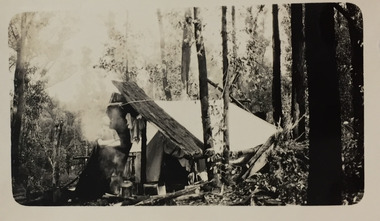
 Kew Historical Society Inc
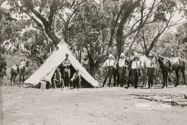
Photograph - Campsite in the Grampians, 1924
... the Yarra River at Studley Park and at Kew. The remainder... pages in the album document the Yarra River at Studley Park ...Henry Beater Christian (1886-1962) , was a descendant of one of the earliest settler families in Kew. Employed at the Kew Asylum as a 'public servant', he was a skilled amateur photographer, photographing numerous scenes in Kew and on his travels around Victoria. The majority of his photographs date from 1916 to 1929. His finest photographs are housed in two photograph albums. Digital copy of a photograph from page 12 of the 47-page photograph album containing 261 gelatinous silver images, loaned by Diane Washfold with permission given to digitise and hold a copy in our collection. The first and last pages in the album document the Yarra River at Studley Park and at Kew. The remainder of the album includes photographs of walking and car tours in rural Victoria including 'wilderness' areas in the Grampians, Gippsland and the High Country. Six album pages document a camping trip by Henry Christian to the Grampians in September 1924. The photos include pictures of lookouts, and natural features including rock faces and waterfalls, as well as his camp site. This photo is of one of his campsites. The tent, beside which a man is standing, is a simple canvas sheet is supported by saplings and ropes. "Mt Victory / Grampians / 9.24"henry beater christian (1886-1962), landscape photography, christian-washfold collection, photograph albums, grampians, mt victory, gariwerd -
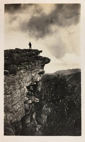
 Kew Historical Society Inc
Photograph - Grampians, 1924
... the Yarra River at Studley Park and at Kew. The remainder... collection. The first and last pages in the album document the Yarra ...Henry Beater Christian (1886-1962) , was a descendant of one of the earliest settler families in Kew. Employed at the Kew Asylum as a 'public servant', he was a skilled amateur photographer, photographing numerous scenes in Kew and on his travels around Victoria. The majority of his photographs date from 1916 to 1929. His finest photographs are housed in two photograph albums. Digital copy of a photograph from page 15 of the 47-page photograph album containing 261 gelatinous silver images, loaned by Diane Washfold with permission given to digitise and hold a copy in our collection. The first and last pages in the album document the Yarra River at Studley Park and at Kew. The remainder of the album includes photographs of walking and car tours in rural Victoria including 'wilderness' areas in the Grampians, Gippsland and the High Country. Six album pages document a camping trip by Henry Christian to the Grampians in September 1924. The photos include pictures of lookouts, and natural features including rock faces and waterfalls, as well as his camp site. This is a photo of a man wearing a hat and sturdy walking clothes standing on the edge of one of the precipitous lookouts at the Grampians. The man may be Henry Christian or a companion."Grampians"henry beater christian (1886-1962), landscape photography, christian-washfold collection, photograph albums, grampians, gariwerd -
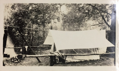
 Kew Historical Society Inc
Photograph - Campsite in the Grampians, 1924
... the Yarra River at Studley Park and at Kew. The remainder... the Yarra River at Studley Park and at Kew. The remainder ...Henry Beater Christian (1886-1962) , was a descendant of one of the earliest settler families in Kew. Employed at the Kew Asylum as a 'public servant', he was a skilled amateur photographer, photographing numerous scenes in Kew and on his travels around Victoria. The majority of his photographs date from 1916 to 1929. His finest photographs are housed in two photograph albums. Digital copy of a photograph from page 15 of the 47-page photograph album containing 261 gelatinous silver images, loaned by Diane Washfold with permission given to digitise and hold a copy in our collection. The first and last pages in the album document the Yarra River at Studley Park and at Kew. The remainder of the album includes photographs of walking and car tours in rural Victoria including 'wilderness' areas in the Grampians, Gippsland and the High Country. Six album pages document a camping trip by Henry Christian to the Grampians in September 1924. The photos include pictures of lookouts, and natural features including rock faces and waterfalls, as well as his camp site. This photo is of a campsite with a pitched tent supported by slabs of bark and ropes. A man is standing in front of the tent partly obscured by the smoke."Grampians"henry beater christian (1886-1962), landscape photography, christian-washfold collection, photograph albums, grampians, mt victory, gariwerd -
 Kew Historical Society Inc
Photograph, Floods in North Kew, 1934
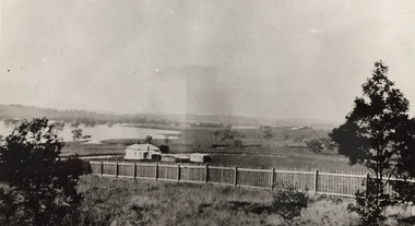
... . This was compounded by the area being bounded on three sides by rivers (Yarra... by the area being bounded on three sides by rivers (Yarra River ...Living with natural processes was frequently a challenge to early European settlers and later residents of what was in the 1850s administered by the Borondara Road Board. This was compounded by the area being bounded on three sides by rivers (Yarra River, Koonung Creek and Gardiner's Creek). In 1849, the historian James Bonwick recorded that "our district [Kew] suffered considerably. Mr Wade speaks of 80 acres, out of 100 acres of his cultivated paddock, covered by water." Newspapers continued to describe major flooding in Kew in 1863, 1869, 1878, 1880, 1889, 1891, 1916 and 1934. While the construction of the Upper Yarra dam in 1957 reduced the levels of flowing downstream, local and riverine floods continue.The Kew Historical Society's pictures and map collections testify to the impact of flooding in the district. They have historical importance in documenting the extent of flooding in the district and its affects on homes, services and recreation. Numerous photographs record flooding throughout the Twentieth Century.Floods in North Kew, 1934. Vicinity of Willsmere Park.floods (kew) -
 Kew Historical Society Inc
Photograph, Wade's Farm, Kilby Road, Nineteenth Century
... at the end of Belford Road near the Yarra River (now part of the Kew... the brickworks on Wade's Farm at the end of Belford Road near the Yarra ...""The public trial of reaping machines, under the auspices of the Port Phillip Farmers' Society, advertised to take place on Friday, last, but postponed on account of the weather, came off December 27. The place selected (Mr. Wade's farm, Belford, near Kew) is undulating ground, with a remarkably heavy crop of wheat upon it. This, taken in connection with, the state of the ground, still soft from the recent rains, made the trial an uncommonly severe one. ..."(South Australian Advertiser, 15 January 1859) Some bricks used in Kew buildings came from the brickworks on Wade's Farm at the end of Belford Road near the Yarra River (now part of the Kew Golf Club). (History of RSL by John Torpey)Wade's Farm, Kilby Road, Kew.wade's farm, farming (kew), kilby road, north kew, belford road, kew, kew golf club -
 Eltham District Historical Society Inc
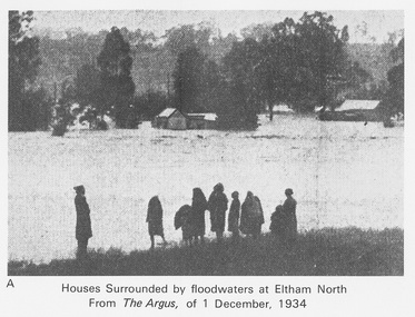
Work on paper (Sub-Item) - Photograph, Houses surrounded by floodwaters at Eltham North
... . In 1934 extensive flooding of the Yarra River and Diamond Creek.... In 1934 extensive flooding of the Yarra River and Diamond Creek ..."The house (centre) at North Eltham in which Mr. and Mrs. William Frizell, an elderly couple, were marooned by flood waters. When this photograph was taken late yesterday afternoon the couple were still inside the house, and through a ventilator they had stuck a red flag which they waved from time to time. The house on the left belongs to Mr. Leads, who also was marooned." - The Argus 1 December 1934. John William Frizell, painter and his wife Sarah Jane are registered at Glen Park, Eltham in the 1924 Electorial Roll This was most probably the Diamond Creek in flood. In 1934 extensive flooding of the Yarra River and Diamond Creek sets new records for flood plain level (via Chronology of Eltham, EDHS) flood, frizell, leads, argus, glen park, eltham north, flooding, marooned, diamond creek -
 City of Moorabbin Historical Society (Operating the Box Cottage Museum)
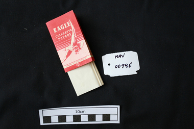
Manufactured objects, Cigarette paper, ‘Eagle’, mid 20thC
... in Victoria on the banks of the Yarra River, Fairfield, Melbourne... of the Yarra River, Fairfield, Melbourne. This was the Australian Paper ...Rolling papers are small sheets, rolls, or leaves of paper which are sold for rolling cigarettes either by hand or with a rolling machine. When rolling a cigarette, one fills the rolling paper with tobacco. Rolling papers are most commonly made with wood pulp, hemp, flax, or rice straw as a base material. 1860 Samuel Ramsden, a Yorkshire man, founded first paper mill in Victoria on the banks of the Yarra River, Fairfield, Melbourne. This was the Australian Paper and Pulp Company which for most of its history was called The Australian Paper Manufacturers Ltd. until it changed its name in 1986 to Amcor. In 1919 the company opened its mill on the corner of Upper Heidelberg Road and The Chandler Highway in Fairfield and remains there today. A packet of pre-cut cigarette papers 'Eagle ' brandEAGLE / CIGARETTE / PAPERS / MADE IN AUSTRALIA back 60 PAPERSciagarette papers, cigarettes, tobacco, melbourne, moorabin, paper mills, eagle cigarette papers ltd, australian paper manufacturers ltd, fairfield victoria, -
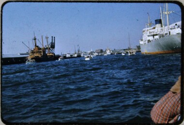 Melbourne Legacy
Slide, Operation Float 1957, 1957
... A colour slide small boats on the Yarra River or Port... A colour slide small boats on the Yarra River or Port Philip ...A colour slide small boats on the Yarra River or Port Philip alongside larger moored boats in 1957. Operation Float was an event run by Melbourne Legacy to take Junior legatees on an outing. It could have been to naval boats such as HMAS Cerberus or to a Yacht club. It gave the junior legatees the opportunity to see a naval boat in action, spend time on the water or try sailing. In 1957 it appears to be several smaller boats taking small groups of children out on the bay. Was with many other slides taken in the 1950s and 1960s. The slides have been photographed to make digital images and moved to archive quality sleeves. In many cases the original images were not well focussed and the digital image the best available.A record of outings being organised for children.Colour slide of 5 or 6 small boats on the Yarra or bay in a red edged Kodachrome cardboard mount.Printed on reverse in red ink 'Kodachrome Transparency / Processed by Kodak'. Handwritten in blue ink 'A new view of Melb / 24 / 1957'. Imprinted in black ink '18'operation float, junior legatee outings -
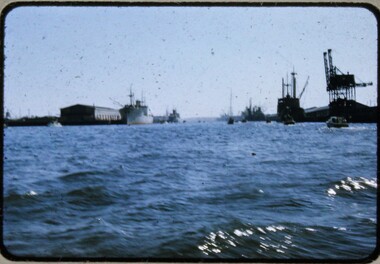 Melbourne Legacy
Slide, Operation Float 1957, 1957
... A colour slide small boats on the Yarra River or Port... A colour slide small boats on the Yarra River or Port Philip ...A colour slide small boats on the Yarra River or Port Philip alongside larger moored boats in 1957. Operation Float was an event run by Melbourne Legacy to take Junior legatees on an outing. It could have been to naval boats such as HMAS Cerberus or to a Yacht club. It gave the junior legatees the opportunity to see a naval boat in action, spend time on the water or try sailing. In 1957 it appears to be several smaller boats taking small groups of children out on the bay. Was with many other slides taken in the 1950s and 1960s. The slides have been photographed to make digital images and moved to archive quality sleeves. In many cases the original images were not well focussed and the digital image the best available.A record of outings being organised for children.Colour slide of small boats on the Yarra or bay in a red edged Kodachrome cardboard mount.Printed on reverse in red ink 'Kodachrome Transparency / Processed by Kodak'. Handwritten in blue ink 'Heading up river / 22 / 1957'. Imprinted in black ink '19'operation float, junior legatee outings -
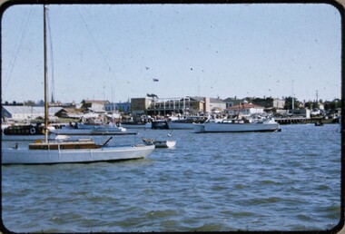 Melbourne Legacy
Slide, Operation Float 1957, 1957
... A colour slide small boats on the Yarra River or Port... A colour slide small boats on the Yarra River or Port Philip ...A colour slide small boats on the Yarra River or Port Philip in 1957. Operation Float was an event run by Melbourne Legacy to take Junior legatees on an outing. It could have been to naval boats such as HMAS Cerberus or to a Yacht club. It gave the junior legatees the opportunity to see a naval boat in action, spend time on the water or try sailing. In 1957 it appears to be The Royal Victorian Motor Yacht Squadron using several smaller boats taking small groups of children out on the bay. Was with many other slides taken in the 1950s and 1960s. The slides have been photographed to make digital images and moved to archive quality sleeves. In many cases the original images were not well focussed and the digital image the best available.A record of outings being organised for children.Colour slide of small boats on the Yarra or bay in a red edged Kodachrome cardboard mount.Printed on reverse in red ink 'Kodachrome Transparency / Processed by Kodak'. Handwritten in blue ink 'RVMYC who gave us Operation Float / 26 / 1957'. Imprinted in black ink '20'.operation float, junior legatee outings -
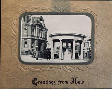 Kew Historical Society Inc
Postcard, Greetings from Kew, c.1928
... Park Road, River Yarra showing new Bridge [Chandler Hwy], High...: Studley Park Road, River Yarra showing new Bridge [Chandler Hwy ...An item from an outstanding and diverse photographic collection, assembled by members of the Christian and Washfold families of Kew.Rae series of postcards, otherwise unknown, showing important sites in KewSmall folding postcard including nine black and white postcard views of Kew. Cover depicts Kew War Memorial set within an embossed cardboard frame. Individual postcards include: Studley Park Road, River Yarra showing new Bridge [Chandler Hwy], High Street showing soldier's memorial, River Yarra at Victoria Bridge, The Yarra at Studley Park, Holy Trinity Church, the [Alexandra] Gardens, New Yarra Bridge [Burke Rd], Soldiers' Memorial and Post Office Kewwashfold family, christian-washfold collection, postcards -- kew (vic.)