Showing 25228 items matching "north"
-
 Eltham District Historical Society Inc
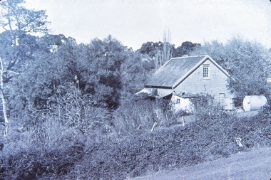
Photograph - Aerial Photograph, Landata, Research, Vic, Apr. 1963
Centred on present day Thompson Crescent and Nicholson Close, Research bounded by Maroondah Aqueduct to north, Nyora Road to south, Eltham College to east and Eltham Gateway Hotel to west. Historic Aerial Imagery Source: Landata.vic.gov.au Aerial Photo Details: Project No :486 Project : MELBOURNE (1963) PROJECT Run : 5 Frame : 61 Date : 04/1963 Film Type : B/W Camera : RC8 Flying Height : 5100 Scale : 9600 Film Number : 1805 GDA2020 : 37°42'24"S, 145°10'06"E MGA2020 : 338528, 5825143 (55) Melways : 22 D3 (ed. 42)aerial photo, neil webster collection, eltham, 1963-04, eltham college, eltham gateway hotel and conference centre, maroondah aqueduct, melway 22d3, nicholson close, nyora road, research (vic.), thompson crescent -
 Eltham District Historical Society Inc
Photograph - Aerial Photograph, Landata, Eltham, Vic, Apr. 1963
Centred on present day John Street, Eltham between Main and Bible streets bounded by Elsa Court to north, Main Road Bridge to south, Wattle Grove to east and Bolton Street to west. Historic Aerial Imagery Source: Landata.vic.gov.au Aerial Photo Details: Project No :486 Project : MELBOURNE (1963) PROJECT Run : 6 Frame : 123 Date : 04/1963 Film Type : B/W Camera : RC8 Flying Height : 5100 Scale : 9600 Film Number : 1805 GDA2020 : 37°43'12"S, 145°08'54"E MGA2020 : 336800, 5823623 (55) Melways : 21 J6 (ed. 42)aerial photo, neil webster collection, 1963-04, bolton steet, elsa court, eltham, john street, main road, main road bridge, melway 21j6, wattle grove -
 Eltham District Historical Society Inc
Photograph - Aerial Photograph, Landata, Eltham, Vic, Apr. 1963
Centred on present day Eltham Ridge, Bolton Street, Eltham bounded by Elsa Court to north, Main Road to south, Bible Street to east and Reichelt Avenue and Rattray Road to west. Historic Aerial Imagery Source: Landata.vic.gov.au Aerial Photo Details: Project No :486 Project : MELBOURNE (1963) PROJECT Run : 6 Frame : 124 Date : 04/1963 Film Type : B/W Camera : RC8 Flying Height : 5100 Scale : 9600 Film Number : 1805 GDA2020 : 37°43'12"S, 145°08'16"E MGA2020 : 335876, 5823604 (55) Melways : 21 G6 (ed. 42)aerial photo, neil webster collection, 1963-04, bible street, bolton street, eltham, eltham ridge, main road, montmorency, rattray road, reichelt avenue -
 Eltham District Historical Society Inc
Photograph - Aerial Photograph, Landata, Eltham, Vic, Apr. 1963
Centred on present day Griffith Park Road, Eltham bounded by Mount Pleasant Road to north, Yarra River and Templestowe to south, Main Road at Reynolds Road to east and Falkiner Street to west. Historic Aerial Imagery Source: Landata.vic.gov.au Aerial Photo Details: Project No :486 Project : MELBOURNE (1963) PROJECT Run : 7 Frame : 233 Date : 04/1963 Film Type : B/W Camera : RC8 Flying Height : 5100 Scale : 9600 Film Number : 1805 GDA2020 : 37°44'04"S, 145°09'10"E MGA2020 : 337237, 5822053 (55) Melways : 22 A10 (ed. 42)aerial photo, neil webster collection, 1963-04, eltham, falkiner street, griffith park road, melway 22a10, mount pleasant road, reynolds road, templestowe, yarra river -
 Eltham District Historical Society Inc
Photograph - Aerial Photograph, Landata, Eltham, Vic, Apr. 1972
Centred on present day Zig Zag Road near Coolabah Drive, Eltham bounded by Allendale Road to north, Park West Road to south, Parsons Road to east and Banks Road to west. Historic Aerial Imagery Source: Landata.vic.gov.au Aerial Photo Details: Project No :985 Project : MELBOURNE 1972 Run : 26 Frame : 191 Date : 04/1972 Film Type : B/W Camera : RC10 Flying Height : 5700 Scale : 9600 Film Number : 2636 GDA2020 : 37°41'56"S, 145°09'26"E MGA2020 : 337533, 5826000 (55) Melways : 22 A1 (ed. 42)aerial photo, neil webster collection, 1972-04, allendale road, eltham, eltham north, zig zag road, banks road, coolabah drive, melway 22a1, park west road, parsons road -
 Eltham District Historical Society Inc
Photograph - Aerial Photograph, Landata, Eltham, Vic, Apr. 1972
Centred on present day Parsons Road, Eltham bounded by Allendale Road to north, Frank Street to south, Research Shops and Raglan Road to east and Zig Zag Road to west. Historic Aerial Imagery Source: Landata.vic.gov.au Aerial Photo Details: Project No :985 Project : MELBOURNE 1972 Run : 26 Frame : 192 Date : 04/1972 Film Type : B/W Camera : RC10 Flying Height : 5700 Scale : 9600 Film Number : 2636 GDA2020 : 37°42'00"S, 145°09'59"E MGA2020 : 338360, 5825897 (55) Melways : 22 D1 (ed. 42)aerial photo, neil webster collection, 1972-04, allendale road, eltham, zig zag road, frank street, melway 22d1, parsons road, raglan road, research (vic.), research shops, eltham barrel -
 Eltham District Historical Society Inc
Photograph - Aerial Photograph, Landata, Eltham, Vic, Apr. 1972
Centred on present day Woodridge Estate, Eltham bounded by Park Road to north, Mount Pleasant Road to south, Stokes Orchard Estate to east and Eltham Railway Station to west. Historic Aerial Imagery Source: Landata.vic.gov.au Aerial Photo Details: Project No :985 Project : MELBOURNE 1972 Run : 27 Frame : 46 Date : 04/1972 Film Type : B/W Camera : RC10 Flying Height : 5700 Scale : 9600 Film Number : 2636 GDA2020 : 37°42'49"S, 145°09'46"E MGA2020 : 338053, 5824365 (55) Melways : 22 C5 (ed. 42)aerial photo, neil webster collection, 1972-04, eltham, eltham railway station, melway 22c5, mount pleasant road, park road, stokes orchard estate, woodridge estate -
 Eltham District Historical Society Inc
Photograph - Aerial Photograph, Landata, Eltham, Vic, Apr. 1972
Centred on present day Main Road at Pryor Street, Eltham bounded by Park West Road to north, Napoleon Street to south, Woodridge Estate to east and Ryans Road to west. Historic Aerial Imagery Source: Landata.vic.gov.au Aerial Photo Details: Project No :985 Project : MELBOURNE 1972 Run : 27 Frame : 47 Date : 04/1972 Film Type : B/W Camera : RC10 Flying Height : 5700 Scale : 9600 Film Number : 2636 GDA2020 : 37°42'45"S, 145°09'12"E MGA2020 : 337223, 5824470 (55) Melways : 22 A4 (ed. 42)aerial photo, neil webster collection, 1972-04, eltham, eltham railway station, woodridge estate, eltham shops, main road, melway 22a4, napoleon street, park west road, pryor street, ryans road -
 Eltham District Historical Society Inc
Photograph - Aerial Photograph, Landata, Eltham, Vic, Apr. 1972
Centred on present day Dalton Street at Mount Pleasant Road, Eltham bounded by Arthur Street to north, Yarra River and Kent Hughes Road to south, Eucalyptus Road to east and Susan Street to west. Historic Aerial Imagery Source: Landata.vic.gov.au Aerial Photo Details: Project No :985 Project : MELBOURNE 1972 Run : 28 Frame : 208 Date : 04/1972 Film Type : B/W Camera : RC10 Flying Height : 5700 Scale : 9600 Film Number : 2635 GDA2020 : 37°43'29"S, 145°08'54"E MGA2020 : 336816, 5823118 (55) Melways : 21 J8 (ed. 42)aerial photo, neil webster collection, 1972-04, eltham, arthur street, dalton street, eucalyptus road, kent hughes road, melway 21j8, mount pleasant road, susan street, yarra river -
 Eltham District Historical Society Inc
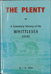
Book, J. W. Payne, The Plenty: A Centenary History of the Whittlesea Shire, 1975
This book traces the one hundered years of the development of the Shire of Whittlesea, from the discovery by Hume and Hovell in 1824 to the time of the centenary in 1975. The intervening years saw the settlement of Vandemonians, Sydney-siders, English, Scots, Irish and Germans, Black Thursday, the building of the Yan Yean Reservoir, the Plenty River flour millls, the timber industry, fruit-growing and export and vineyards. Personalities and pubs, subdivisions, stories of the Findon Hunt Club and various Shires including Epping. History of education and transiton from rural to urban in the south of the Shire. The work is illustrated with maps and photographs. The Shire is now the City of Whittlesea and is an immediate neighbour to the north of the Shire of Nillumbik. shire of whittlesea -
 Eltham District Historical Society Inc
Photograph, 19 Rockcliffe Street (Brougham Street entrance), Eltham, 3:30pm, 5 July 1967, 1967
Lot 6 L.P. 9499 at eastern most end of Brougham Street Property has since been subdivided and this access end is now 146 Brougham Street Photo taken by Russell Yeoman, Planning Department, Shire of Eltham In the 1954 Electoral Roll Ella Dunkel was listed as living in Diamond Street, Home Duties. In the 1963/1967/1968/1972/1977 electoral rolls she was listed at 19 Rockcliffe Road, Home Duties. Probate was granted 18 July 1979 (Wills and Probate Records. VPRS 28 (Probates) and VPRS 7591 (Wills). Public Record Office Victoria, North Melbourne, Victoria.)Polaroid photographPolaroid Manufacturer Code K603831 #7brougham steet, houses, rockcliffe street, eltham, ella dunkel -
 Eltham District Historical Society Inc
Photograph, 19 Rockcliffe Street (Brougham Street entrance), Eltham, 3:30pm, 5 July 1967, 1967
Lot 6 L.P. 9499 at eastern most end of Brougham Street Property has since been subdivided and this access end is now 146 Brougham Street Photo taken by Russell Yeoman, Planning Department, Shire of Eltham In the 1954 Electoral Roll Ella Dunkel was listed as living in Diamond Street, Home Duties. In the 1963/1967/1968/1972/1977 electoral rolls she was listed at 19 Rockcliffe Road, Home Duties. Probate was granted 18 July 1979 (Wills and Probate Records. VPRS 28 (Probates) and VPRS 7591 (Wills). Public Record Office Victoria, North Melbourne, Victoria.) 35mm colour positive transparency blue Agfacolour Service plastic mountSlide is marked 19 July 1967 but identical to Polaroid taken by Russell Yeoman at 3:30pm on 5 July 1967 Slide also inscribed E-B and Gp PSCbrougham steet, houses, rockcliffe street, eltham, ella dunkel -
 Greensborough Historical Society
Photograph - Digital Image, Willis Vale, 1950c
Willis Vale: House built by Edward Maygar, Robert Whatmough lived there mid 19th century and later sold to Partington family. It was located on the Plenty River at Partington's Flat Greensborough. Land use included farming and orchards. The derelict Willis Vale house was vandalized in 1964 and destroyed when a fire originating from North Plenty Gorge - Kurrak Road - was lit by two teenage boys and made its way several kilometres down to Partington's Flat Greensborough. This photo was taken after the Partington's moved house in 1947 across the river where Alan built their new Alwyn house that had access to electricity.Home of the Partington familyDigital copy of black and white photograph.willis vale, partington family, whatmough, maygar family -
 Greensborough Historical Society
Photograph - Digital Image, Willis Vale, 1950c
Willis Vale: House built by Edward Maygar, Robert Whatmough lived there mid 19th century and later sold to Partington family. It was located on the Plenty River at Partington's Flat Greensborough. Land use included farming and orchards. The derelict Willis Vale house was vandalized in 1964 and destroyed when a fire originating from North Plenty Gorge - Kurrak Road - was lit by two teenage boys and made its way several kilometres down to Partington's Flat Greensborough. This photo was taken after the Partington's moved house in 1947; across the river where Alan built their new Alwyn house that had access to electricity.Home of the Partington familyDigital copy of black and white photograph.willis vale, partington, whatmough, maygar -
 Eltham District Historical Society Inc
Photograph, Eltham campers
Barbara Seidel of Eltham has provided a copy of a photo of a group known as the "Eltham Campers" which included some of her relatives. Jock Read and Garnie Burges remember this group from the 1920's. They used to camp on the old pound site at Eltham Lower Park. They met in North Fitzroy and every A.N.A. weekend they cam to Eltham to camp. They had big tents and set up a stage on backs of their wagons or lorries. A concert was held on the Sunday night for local people to attend. They had very good artists including a pianist, violinist, flautist and banjo player. - EDHS Newsletter No. 83, March 1992Colour photograph copy of original showing a camping group at Eltham known as the Eltham Camperscamps, campers, eltham, groups, eltham campers, eltham lower park, eltham pound, concert -
 Orbost & District Historical Society
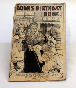
magazine, Foster McClellan, Doan's Birthday Book, 1908
"James Doan was a doctor who lived in a town called Kingsville, in Canada, in North America. Sick people took journeys of many days to go to see him, and to get his medicine. He was a doctor who excelled in his neighborhood, because he prepared his medicine with his own hands, so he knew it was well prepared, and good. He used to make it with shrubs, and roots, and herbs, which he gathered in the woods and veld near his home. He made many kinds of medicine; but the most excellent is that which is called Doan’s Backache Kidney Pills." (info. from raycityhistory website)This magazine reflects the popularity of over the counter remedial medications in the early 20th century.A small magazine advertising medicines. It is titled, "Doan's Birthday Book". On the front cover is an illustration of an older lady, a cat on her lap and holding a walking stick, reading to two young girls.doan's-medications medicine -
 Glen Eira Historical Society
Document - CUMBERNAULD
This file contains nine pages about people related to this property: 1/Copy and pasted eight pages taken from Census Records and Trove items. Articles include the death of Thomas Livingstone Cleland during WWI. Various social notes regarding his family up to 1953. There are articles on the W.J. Mathieson family, who also resided there, as well as residing in Benalla. 2/Print from Trove of an article from the 23/11/1934 edition of The North Eastern Ensign (Benalla, Vic) about the wedding anniversary of Mr and Mrs W.J. Mathieson, held at Cumbernauld on 27/10/1934.cumbernauld, thornleigh grange, house names, cleland thomas livingstone, cleland annie, gardeners market, clayton road, ‘hillside’, caulfield, anderson street, cleland sydney, cleland margaret, cleland james, cleland adelaide, cleland robert, cleland bessie adelaide, cleland agnes, cleland lily, cleland alick douglas milkman, cleland aggie, cleland tom h.s. draftsman, cleland kenneth malcolm, cleland ethel, cleland hector, cleland edna may, mathieson w.j., mathieson isabel, burrows f.a. lieut., east st. kilda, hawthorn road, ‘thornleigh grange’, south caulfield progress association, south caulfield junction, caulfield court, jenkins harry, giles alfred, grafton street, elsternwick, dawes john, chloris crescent, st. john’s presbyterian church, mathieson evelyn mary, marks theodore leslie, mathieson kitty, masonic hall, st. george’s road, haverfield frank, haverfield mrs, haverfield robert ross, rynn mary buckley, cyclists, cycling, donald alexander, martin lottie, whitelaw joan, trinity hall, brighton road, gilmore patricia phyllis, brooklyn ave., point nepean road, north road, brighton court, cleland nora, seaview drive, cleland john stuart, mathieson isabella cristina, kalymna grove, mathieson catherine m., tailor, mathieson william james, councillors, social events and activities, births deaths and marriages, anniversaries, world war 1914-18, soldiers -
 Federation University Historical Collection
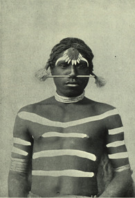
Image - black and white, Barwon River Man (New South Wales)
Digitised directly from 'The Native Races of the British Empire: Victoria' The Barwon River in New South Wales is formed through the confluence of the Macintyre River and Weir River (part of the Border Rivers system), north of Mungindi, in the Southern Downs region of Queensland. The Barwon River generally flows south and west, joined by 36 tributaries, including major inflows from the Boomi, Moonie, Gwydir, Mehi, Namoi, Macquarie, Bokhara and Bogan rivers. During major flooding, overflow from the Narran Lakes and the Narran River also flows into the Barwon. The confluence of the Barwon and Culgoa rivers, between Brewarrina and Bourke, marks the start of the Darling River.Black and white Image of an Aboriginal man from Barwon River, New South Wales. Aboriginal people from six language groups originally occupied the area of the Barwon River wetlands. These were the Ngemba, the Baranbinja, the Murrawari, the Ualayai, the Weilwan, and the Kamilaroi peoples. The Aboriginal people generally used the wetlands for hunting, fishing, and gathering uses, and for cultural association.(Wikipedia) The name "barwon" is derived from the Australian Aboriginal words of barwum or bawon, meaning great, wide, awful river of muddy water; and also baawan, a Ngiyambaa name for both the Barwon and Darling rivers. The history, culture and livelihoods of the local Aboriginal people are closely intertwined with the Barwon River and its associated tributaries and downstream flows. (Wikipedia)aborigine, aboriginal, barwon river -
 National Wool Museum
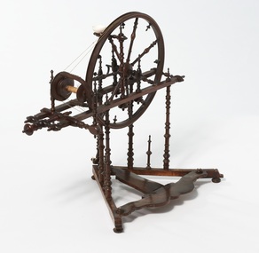
Spinning Wheel
Part of the Zakrzewski Collection of spinning wheels donated to the National Wool Museum by Mr Wlodzimierz Zakrzewski. For many years, Mr Zakrzewski collected, researched and repaired spinning wheels from all over the world. This wheel is from Northern France-Flanders and was used for spinning flax to make the fine thread needed for lace making. It dates from the 19th century and bears the names Thirion and Villotte. Research by Mr Zakrzewski indicates that Villotte was a tiny village in the north of France and that Thirion is probably the name of the maker. This wheel was purchased from Margaret and Joan Mellor who were well known in Melbourne as teachers of hand spinning and weaving.Part of the Zakrzewski Spinning Wheel collection.Thirion / Villottehandicrafts - history flax, spinning wheels, highlights of the national wool museum: the zakrzewski spinning wheel collection - exhibition (28/07/2001 - 02/12/2001), zakrzewski, mr wlodzimierz, handicrafts - history, flax -
 8th/13th Victorian Mounted Rifles Regimental Collection
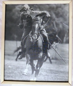
Photograph - Tent-pegging
Trooper C. Ellison, a member of the 8/13 Victorian Mounted Rifles Heritage Troop participating in a display of tent-pegging at a local show. The Heritage Troop of 8/13 Victorian Mounted Rifles was a very public face of the regiment during the 1980s and early 1990s. It conducted one royal escort, several vice-regal escorts and numerous VIP escorts in the border, north-east and wider Victorian locations. The royal duty was at the opening of Hopkins Barracks, Puckapunyal by HRH Prince Charles accompanied by HRH Princess Diana, 31 October 1985. The troop was an extra curriculum activity of serving members of 8/13 VMR. Framed black and white photograph of light horseman engaged in tent-pegging. military, light horse, tent-pegging, cavalry, ellison -
 8th/13th Victorian Mounted Rifles Regimental Collection
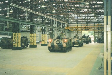
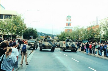
Photograph - March in 105
On Saturday 13 May 2000, Victorian Mounted Rifles Squadron, 4th/19th Prince of Wales's Light Horse Regiment departed Buna Barracks Albury and relocated to its new depot at Building 105 North Bandiana. The occasion was marked by a parade through the main streets of Albury and Wodonga. The mayor of Albury, Councillor Les Langford, farewelled the regiment and the mayor of Wodonga, Councillor Graham Crapp, welcomed the regiment to Wodonga. At Building 105, the Area Commander, Colonel Chris Anstey, welcomed the regiment and handed over the building to Lieutenant Colonel Michael Annett, Commanding Officer 4th/19th Prince of Wales's Light Horse. Colour photograph of three M113 Light Reconnaissance Vehicles (LRVs) driving into a large timber framed building.annett, anstey, bandiana, crapp, langford, buna barracks, 4th/19th, vmr -
 8th/13th Victorian Mounted Rifles Regimental Collection
Photograph - March in 105
On Saturday 13 May 2000, Victorian Mounted Rifles Squadron, 4th/19th Prince of Wales's Light Horse Regiment departed Buna Barracks Albury and relocated to its new depot at Building 105 North Bandiana. The occasion was marked by a parade through the main streets of Albury and Wodonga. The mayor of Albury, Councillor Les Langford, farewelled the regiment and the mayor of Wodonga, Councillor Graham Crapp, welcomed the regiment to Wodonga. At Building 105, the Area Commander, Colonel Chris Anstey, welcomed the regiment and handed over the building to Lieutenant Colonel Michael Annett, Commanding Officer 4th/19th Prince of Wales's Light Horse. Colour photograph of M113 Light Reconnaissance Vehicles (LRV) of Victorian Mounted Rifles Squadron, 4th/19th Prince of Wales's Light Horse regiment parading through Dean Street Albury.annett, anstey, bandiana, langford, 4th/19th, vmr, band, albury -
 Ballarat Tramway Museum
Postcard, Valentine & Sons Publishing Co, "Lydiard Street showing George Hotel Ballarat", 1931
Valentine Series postcard of the early 1930s of No. 27 inbound in Lydiard St Nth. Valentine series No. 1492, with the caption "Lydiard Street showing George Hotel, Ballarat". See page 59 of The Golden City and its Tramways and for the photo itself. Photo shows the wooden centre poles, street lighting, tram 27 in ESCo colour scheme, and buildings on the west side of Lydiard St North, including the George Hotel, A.M. Palmer & Co Chemist, Wm Hiscock Dentist and other buildings. A horse-drawn cart and two motor cars parked at the kerb. See 3893 for a digital image and reproduction photograph.Yields information about Lydiard St Nth in the 1930's, the centre poles, traffic and the appearance of the trams.Postcard black and white, divided back. Card No. 1492Has on the rear in pencil "KT" and "to be copied" tramways, trams, tram 27, lydiard st nth, george hotel, centre poles -
 Ballarat Tramway Museum
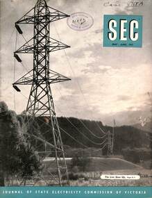
Magazine, State Electricity Commission of Victoria (SECV), SEC News, May June 1953
Published for the staff of the SEC, features the Kiewa Valley transmission line, North East towns and workers, industry, Bendigo Tram's Golden Jubilee, (AETA Visit, Mr George Laurens, Doug Dean, Tom Lynch and Basil Miller), electrical safety, meter reading in the country, sports, electric cooking, and sports section. In the retirements were Mr P Pithie, Senior Traffic Inspector Geelong, Mr V Pipps Depot Foreman Geelong and Mr S Watson, Geelong Senior depot clerk. On the inside cover are photos of the package power stations being installed at Geelong, Ballarat (Ballarat B) and Mildura.Demonstrates a SECV Staff magazine.Magazine, 36 pages, black and white production, centre stapled.Has RHSV stamp on the cover and "Case ViiiA" in inktramways, geelong, secv, retirements, ballarat b power station, power stations, bendigo -
 Queenscliffe Maritime Museum
Equipment - Float
Norway, around 1840, was the first country to produce and use glass fishing floats. Many of them can still be found in local boathouses. Christopher Faye, a Norwegian merchant from Bergen, is credited with their invention. The earliest floats, including most Japanese glass fishing floats, were handmade by a glassblower. Recycled glass, especially old sake bottles in Japan, was typically used and air bubbles/imperfections in the glass are a result of the rapid recycling process. Glass floats have since been replaced by aluminum, plastic, or Styrofoam. Today most of the glass floats remaining in the ocean are stuck in a circular pattern of ocean currents in the North Pacific.By the 1940s, glass had replaced wood or cork throughout much of Europe, Russia, North America, and Japan. Japan started using the glass floats as early as 1910. Now they are still highly sought after as decoration.A glass float with intact knotted rope net attachedfishing, floats, glass floats -
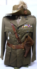 8th/13th Victorian Mounted Rifles Regimental Collection
Uniform - Fyffe uniform & hat, 1945 circa
VX 42774 Captain Robert (Bob) Fyffe, a grazier from Tocumwal, NSW, served with the Tocumwal troop of the 20th Light Horse prior to WWII (1939-46). He enlisted at the outbreak of war and served with the 9th Division Cavalry Regiment in North Africa. During the attack on Trig 22 on 17 July 1942 Captain Fyffe commanding a composite squadron manoeuvred his tanks to knock out machine guns and anti-tank guns enabling 2/32 Battalion to capture the objective. Captain Fyffe was awarded the Military Cross for his leadership and courage in the action. This was 9th Division Cavalry's first tank action of the war.Fine example of a uniform worn by a well known grazier and citizen soldier of the Tocumwal district, southern NSW, in both peace and war.Khaki wool serge officer's tunic with leather Sam Browne belt and revolver holster, and slouch hat with emu plumes and 20th Light Horse hat badge against red backing. Tunic has 20th Light Horse colour patches. overseas service chevrons and ribbon bar for Military Cross, 39-45 Star, Africa Star, Defence medal, British War Medal and Australian Service Medal 1939-45; metal Australia shoulder titles captain's rank stars and Rising Sun collar badges. Uniform worn by Captain Robert Fyffe MC, 20th Light Horse and 6th Division Cavalry Regiment AIF.. uniform, fyffe robert captain mc, 20th light horse, 9th division cavalry regiment, military cross -
 Williamstown Botanic Gardens- Hobsons Bay City Council
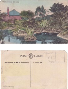
Postcard – Williamstown Botanic Gardens, M Schulz, Prague, c1900-1920
The original postcards in this series (2013.002 to 2013.018) were generously loaned to Williamstown Botanic Gardens by a private collector for copying. The Curator’s lodge, designed by the Town Surveyor, HV Champion, was constructed in 1907 following the re-organisation of the north-east corner with the demolition of the old curator's cottage and erection of new gates. Both the lodge and lake (1904) were built during the curatorship of Mr Thake. The logo in the middle of the words ‘POST CARD’ indicates the card was printed by M. Schulz in Prague. Schulz was a long-established company from Prague and printed postcards for customers from worldwide. Schulz printed in photo-chromolithography. The postcards are evidence of the interest the gardens held as a subject for postcard publishers. The text and images provide a snapshot into fashions, social interests and concerns of the time. The professionally produced images provide a pictorial history of Gardens including changing planting styles, various structures and features of the Gardens eg the aviary, cannons, the fountain, the second Curator’s Lodge and gates. The images offer an opportunity to compare garden vistas with the present day.A colour image of the ornamental lake and part of the Curator’s Lodge. The lodge has a green roof, tall brick chimney, is brown timber with brick where the fireplace would be. The small island with a succulent is in the centre of the image. The image looks across the top of the lake where the rock edging can be seen. Reflections of the plantings and lodge can be seen.Front: ‘Williamstown Gardens’. Reverse: Reverse: Centre top ‘POST CARD’ with a logo [MS] in the middle of the words; left side vertical ‘O. Rippon Series’; left side ‘This space may be used for communication.’; right side ‘For Address only.’; left side bottom ‘Printed in Germany’. In pencil top right corner ‘1907 / $7’ (believed to be inserted by the vendor.postcard, gardens, post-card, williamstown-botanic-gardens, hobsons-bay-city-council, curator’s lodge, ornamental lake, succulents, 1907 -
 Surrey Hills Historical Society Collection
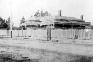
Photograph, 215 Union Road, c 1920
The house was variously known as ‘Mintaro’, ‘Montiere’ and ‘Goonoo Goonoo’, the later after 1920 when it was purchased by Natale Cerini and his wife Ethel May (nee Swan), who were married in 1918. Built 1887-1888 by William Wigley. The original colour was deep cream with dark green trim. Property included a block of land on south side and also land to the north. The original coach house was on what became 213 Union Road and was used to build a yacht in by the then neighbours, the Flemings. The street plane trees were replaced in the 1970s with melaleucas and in 1987 new plane trees were planted between the melaleucas. Sepia copy of an older photo of 215 Union Road from diagonally across the road. Shows street surface, bluestone kerbing, a young tree within a guard and a Victorian style home with 3 chimneys, a slate roof and a veranda on at least the south and west side. Beyond the house are mature cypress and other trees and a spire. The spire belonged to Surrey College, a boys' boarding school (later Nethercourt Hospital and St Judes.)'mintaro', 'montiere', 'goonoo goonoo', william wigley, mrs ethel may cerini, miss ethel may swan, miss jocelyn cerini, mrs jocelyn hall, miss lynette cerini, victorian style, 215 union road -
 Surrey Hills Historical Society Collection
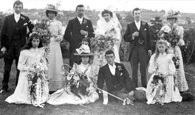
Photograph, Wedding of Annie Beckett and Henry Leigh at Guildford Villa, 21/9/1899, 21/9/1899
Taken at Guildford Villa, which has been demolished, at the wedding of Annie Beckett and Henry Leigh. Background view is to the north with Guildford Road across the photo and Monserrat' on Mont Albert Road on the horizon. Identification: Back row - L to R: Bert Leigh, Katie Beckett, Henry (Harry) Leigh, Annie Beckett, Percy Leigh, Clara Beckett. Front row - L to R: Mabel Beckett, Elsie Beckett, Arthur Leigh, Winnie Leigh. The bride was the daughter of Robert Beckett (senior) of Essex Road and the bridegroom was the son of Timothy Leigh, estate agent and architect of Essex Road. Married at the Wesleyan Church.Both the Beckett and Leigh families were significant in the early days of settlement of Surrey Hills.A B&W photo of bridal party comprised of bride, bridegroom, 3 bridesmaids, 3 male attendants and 2 flowergirls against a largely rural background.guildford villa, weddings, wedding dresses, annie beckett, henry leigh, harry leigh, bert leigh, percy leigh, clara beckett, mabel beckett, elsie beckett, arthur leigh, winnie leigh, topography -
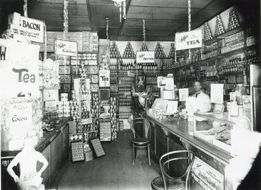 Surrey Hills Historical Society Collection
Photograph, Inside Bill Whittingham's grocery shop, 144 Union Road, 1930
Copied from a glass negative; original photo taken by Ian Barkla's father, Frank Leslie Barkla of 37 Grovedale Road. He was a keen amateur photographer and member of the Melbourne Camera Club. There is also a copy by Ken Hall. Date is approximate. The shops between Croydon and Guildford Road were built at the end of the 1920s and occupied immediately. Next north of Whitty's was H Wichell (bootmaker at 146), J T Poynton (butcher at 148), Mrs A Wardell (confectioner at 150), R J Skinner (grocer at 152), W Ives (fruit and vegetables at 154) and W R Latchford (hardware at 156). Black and white photo of the interior of Bill Whittingham's grocery shop at 144 Union Road, Surrey Hills. There is a counter on the RHS behind which there is a man in a white coat. The counter is stacked at one end with goods and at the other there is a glass case. The shelves at the rear of the shop are stacked high and there are multiple advertising signs, including ones for Perservene soap, Ovaltine, Bourn-vita cocoa and Brockhoff biscuits.Label: "I R Barkla. Collection / Location SURREY HILLS / Date ....... / Neg. No 284"whitty's, advertising, shops, grocers, businesses, union road shops, bill whittingham, frank leslie barkla