Showing 15835 items
matching drives
-
 Wodonga & District Historical Society Inc
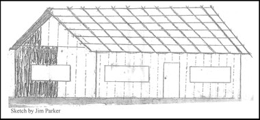
Drawing - The Green Hills School
Green Hills School was the first school in the Wodonga area. Before the school could open and a teacher commence duties, the Government had to be assured that a minimum of 20 children would be attending. The school was built of round timber, slab walls, bark roof, dirt floor and shuttered windows. The school opened in 1850 and closed in 1870. This sketch, completed by Jim Parker, a Life Member of Wodonga & District Historical Society, was included on a commemorative plaque as part of the Wodonga Heritage Drive established by the Society to recognise the story of key historic locations in the Wodonga area.This drawing is significant because it depicts the first school opened in Wodonga.A sketch of Green Hills School completed by Jim Parker, a life member of Wodonga & District Historical Society. This sketch was completed as part of a project to place commemorative plaques at key locations around Wodonga green hills school, wodonga schools, education wodonga -
 Greensborough Historical Society
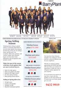
Advertising Leaflet, Barry Plant Bundoora, Barry Plant Spring selling season, 2018_08
Spring selling season leaflet with sales results on back of page. 4 Murumba Street Greensborough, sold $1,115,000 ; 11 Sun Orchid Circuit St Helena sold $870,00; 6 Weemala Court Greensborough sold $1,666,000; 6 Howard Street Greensborough sold $737,000; 136 Elder Street Greensborough sold $772,000; 140 Mountain View Road Briar Hill sold $638,000 and 12 Sunrise Drive Greensborough sold 2018 for $1,320,000, previous sales January 1994 $103,000, July 1989 $100,000 and July 1988 $85,500.Real estate advertising leaflet, 1 sheet, printed in colour on both sides.sunrise drive greensborough, murumba street greensborough, sun orchis circuit st helena, elder street greensborough, howard street greensborough, mountain view road briar hill, weemala court greensborough -
 Greensborough Historical Society
Photographs, Albion Crescent Greensborough, 1920s
Early photographs of Albion Crescent Greensborough. Photographs made prior to surfacing, curbing and guttering road. Joy Darling still living at this address at time of donation. Copies of 3 black and white photographs#1: Looking east along Albion Crescent and up Peter & Joy Darling's drive One of the Darling girls (centre). #2: [Driveway of 33 Albion Crescent, one of Darling girls] #3: Looking east along Albion Crescent from driveway. [Pre-war (WW II) touring car, Joy Darling in car ?]joy darling, albion crescent greensborough -
 Ringwood and District Historical Society
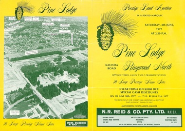
Flyer, Land Auction Sale Brochure, Pine Lodge, Ringwood North, Victoria - 1977
Refer also to Reg. No. 5172 for Pine Lodge Land Auction 3rd release, 1978.Yellow double-sided real estate auction notice with green print showing aerial photograph and map of subdivision layout and summary of local features and services for Pine Lodge, Kalinda Road, Ringwood North. Auction date, Saturday, 4th June, 1977, at 2:30pm.Subdivision plan includes Parkgate Drive, Wood-Church Close, and Pensby Court. (Agent) N.R. Reid & Co. Pty. Ltd., Safeway Centre, Boronia Road, Boronia (Phone) 762 1022, 450 Little Collins Street, Melbourne (Phone) 67 1746, and 207 Stud Road, Wantirna South (Phone) 231 2277. -
 Kew Historical Society Inc
Plan - Subdivision Plan, J R Mathers & McMillan, Normanby Estate, c.1913
The Kew Historical Society's map collection includes a substantial number of real estate subdivision plans, mainly of Kew but also of surrounding suburbs in Melbourne. Most of the subdivision plans date from the 1920s and 1930s when the districts old homes and local farmland were being split up to accommodate residential growth in the postwar period. These early plans were assembled by a local firm, Jas R Mather & McMillan, which had an office in Cotham Road. Many of the plans, and sometimes photos, were annotated by the agents.Subdivision plans are historically important documents used as evidence for the growth of suburbs in Australia. They frequently provide information about when the land was sold as well as evidence relating to surveyors and real estate and financial agents. The numerous subdivision plans in the Kew Historical Society's collection represent working documents, ranging from the initial sketches made in planning a subdivision to printed plans on which auctioneers or agents listed the prices for which individual lots were sold. In a number of cases, the reverse of a subdivision plan in the collection includes a photograph of a house that was also for sale by the agent. These photographs provide significant heritage information relating house design and decoration, fencing and household gardens.The photograph may also be aesthetically significant depending on the importance of the photographic atelier.The Normanby Estate, which was adjacent to Normanby Road, Kew East, included thirty-one lots for sale. Streets on the subdivision plan include Adeney Avenue, Park Hill Road, Normanby Road, Weir Street and Wharton Street. Cotham Road and its tramway are shown nearby. The plan is interesting as it shows Wharton Street, named after the architect and town planner George Wharton, who was the first chairman of the Municipality of Kew. The street was to later be renamed Cecil Street. Also shown are proposed ‘Municipal Gardens’ where Parkhill Drive is now located."D" in top left corner. Stamped auctioneers contact details: "Jas. R. Mathers & Son & McMillan / Auctioneer & Land Salesmen, / 271 Collins Street / Melbourne" and Jas. R. Mathers / Estate & Financial Agent / Cotham Road / Kew".weir street - kew, wharton street - kew, normanby road - kew, cotham road - kew, municipal gardens - kew, park hill parkhill road - kew, braemar - kew, subdivision plans - kew -
 Kew Historical Society Inc
Plan - Subdivision Plan, Normanby Estate, East Kew, 1913
Pru Sanderson, in her groundbreaking ‘City of Kew Urban Conservation Study : Volume 2 - Development History’ (1988), summarised the periods of urban development and subdivisions of land in Kew. The periods that she identified included 1845-1880, 1880-1893, 1893-1921, 1921-1933, 1933-1943, and Post-War Development. These periods were selected as they represented periods of rapid growth or decline in urban development. An obvious starting point for Sanderson’s groupings involved population growth and the associated economic cycles. These cycles also highlighted urban expansion onto land that was predominantly rural, although in other cases it represented the decline and breakup of large estates. A number of the plans in the Kew Historical Society’s collection can also be found in other collections, such as those of the State Library of Victoria and the Boroondara Library Service. A number are however unique to the collection.The Kew Historical Society collection includes almost 100 subdivision plans pertaining to suburbs of the City of Melbourne. Most of these are of Kew, Kew East or Studley Park, although a smaller number are plans of Camberwell, Deepdene, Balwyn and Hawthorn. It is believed that the majority of the plans were gifted to the Society by persons connected with the real estate firm - J. R. Mathers and McMillan, 136 Cotham Road, Kew. The Plans in the collection are rarely in pristine form, being working plans on which the agent would write notes and record lots sold and the prices of these. The subdivision plans are historically significant examples of the growth of urban Melbourne from the beginning of the 20th Century up until the 1980s. A number of the plans are double-sided and often include a photograph on the reverse. The Normanby Estate, which was adjacent to Normanby Road, Kew East, included thirty-one lots for sale. Streets on the subdivision plan include Adeney Avenue, Park Hill Road, Normanby Road, Weir Street and Wharton Street. Cotham Road and its tramway are shown nearby. The plan is interesting as it shows Wharton Street, named after the architect and town planner George Wharton, who was the first chairman of the Municipality of Kew. The street was to later be renamed Cecil Street. Also shown are proposed ‘Municipal Gardens’ where Parkhill Drive is now located.subdivision plans - kew, normanby estate -
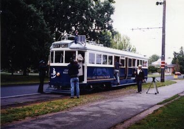 Ballarat Tramway Museum
Photograph - Colour Photograph/s and Letter/s, William. F. Scott, 4/12/1995 12:00:00 AM
Colour photograph of 'City of Ballarat' tram No 671 at St Aidans Drive, following its launch on 4.12.95. TV reporter taking video of front of tram. Carolyn Dean walking by tram. Travis Jeffrey tying trolley rope. Tram has destination of City Circle. Houses and park in background. Photograph is glued to a piece of paper with item No. 469 as well, and a letter from W.Scott to Dave Macartney of 23.1.295 with caption details. Letter has Bill's letterhead - see related documents. If required can be separated from backing paperOn rear in pencil (inside circle) '2' and sticker in bottom corner 'William F. Scott/ 4.12.95, 19'.btm, 671, city of ballarat, launch, tram 671 -
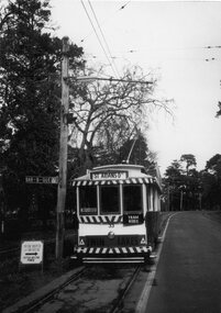 Ballarat Tramway Museum
Photograph - Bromide of a b/w photograph, William. F. Scott, c1990
Bromide of a black and white photograph of Ballarat 33 in Wendouree Parade, operated by the BTPS, descending hill towards Depot Junction. Has destination of "Aidans Drive", with "Twin Lakes" advertisement, and the Museum display sign alongside front of tram. Photograph was used on the front cover of the 1989-90 Annual Report of the BTPS. Caption details "Tram 33 approaches Depot Junction in Wendouree Parade on a quite Winter's day. One of the new Museum signs has just been placed by the driver." Photo c1990. Bromide made c1994 for possible publication, but not used.trams, tramways, wendouree parade, advertisements, museum, btps, tram 33 -
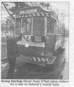 Ballarat Tramway Museum
Newspaper, The Courier Ballarat, "Tram's fate unknown", 9/08/1999 12:00:00 AM
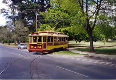
Newspaper clipping from The Courier, Ballarat, Monday 9/8/1999 about the return of trams to Ballarat. Article followed the item in the Melbourne Herald Sun, (Reg. Item 1624) on 6/8/1999 about the same subject and quoting Judy Verlin, the Mayor. Judy Verlin appears to duck the issue a bit in the local paper. Says has not seen the latest report. Also quotes Peter Hiscock of Sovereign Hill. Has photograph of Dave O' Neil putting up the pole on tram 40 at St. Aidans Drive."Page 4, The Courier, Ballarat Monday August 9, 1999" in blue ink along top edge.ballarat revival, st aidans drive, feasibility study -
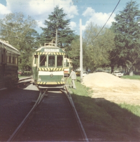 Ballarat Tramway Museum
Photograph - Colour Print/s - set of 7, Stephen Butler, 15/10/1978 12:00:00 AM
Yields information about the people attending and the way the BTPS AGM was held in 1978 at the depot and the trams used.Set of 7 colour prints of the BTPS AGM, 15 Oct. 1978 - See Fares Please! Sept. 1978. .1 - Depot fan - 40 .2 - The meeting assembled .3 - The meeting table - Richard Gilbert, ?, Frank Hanrahan, Carolyn Dean and Bill Jessup .4 - Depot fan - 40, 28 and 38 .5 - depot fan - 40, 27 and 40 .6 - Geoff Dean, Carolyn Dean and David Frost .7 - 14 and 40 at St Aidans Drive. Photos by Stephen Butler. See Fares Please! Sept. 1978"AGM 78" on rear of each in inktrams, tramways, wendouree parade, btps, agm, tram 40, tram 27, tram 14, tram 38 -
 Ballarat Tramway Museum
Photograph - Colour Photograph/s - set of 3, Austin Brehaut, 5/11/2002 12:00:00 AM
Set of three colour photographs of BTM No 28 operating in Wendouree Parade for its first revenue trips taken on 5/11/2002, taken by Austin Brehaut on Kodak Royal Paper. 2266.1 - No. 28 crossing Wendouree Parade from the depot access track. 2266.2 - Austin Brehaut replacing the trolley pole on the wire at St. Aidans Drive 2266.3 - Roger Salen, driver, at No. 2 end of No. 28. A fourth photograph - first passengers - Gardens Loop - sent to Trolley Wire Editor 12/1/2003. Shown in image only.2266.1 - "28 re-enters Wendouree Pde to return to revenue service 5.11.02 / Driver Roger Salen / APB". 2266.2 - "Conductor Austin Brehaut turns the pole at St. Aidans Dve on 28'2 return to revenue service 5.11.02 / APB" 2266.3 - "Roger Salen gets the feel of 28'2 No. 2 end control 5.11.02 / APB",wendouree parade, btm, depot junction, tram 28 -
 Melbourne Tram Museum
Newspaper, The Age, "Trams safety report 'a joke'", Sep. 1998
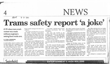
Photocopy of a newspaper report in The Age, 9-9-1998, titled "Trams safety report 'a joke'", written by Lyall Johnson, Transport Reporter, about a report made by consultants for the PTC about the safety of the drivers cab in one-man trams. Notes the consultants did not inspect the tramcars themselves. Quotes Union Secretary Lou DiGregorio, PTC Spokesman Russell Coffey. The Malvern depot was refusing to drive the trams. Report had been prepared by R2A Risk and Reliability Associates Pty Ltd. Commissioned by the PTC. Union want the cabs crash tested.trams, tramways, preston workshops, w class, unions, safety, ptc, one man trams -
 Bendigo Historical Society Inc.
Flag - Aileen and John Ellison Collection: The Churchill flag
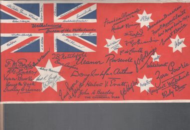
British flag signed by dignitaries and world leaders. The flag was manufactured in 1941/42 as part of the Red Cross drive to raise money. On the back a message to the Hon. Wiston Churchill sent by Australians as an expression of admiration, confidence and gratitude, inspired by the conduct of the citizens of Britain, whose patient endurance, high courage and will to win in the present crisis have proved their loyalty to the tradition of their country and their race and heartened their kinsmen in every corner of the British Empire. Following this message the back of the flag list the name and titles of the signatories and a brief history of the flag and the scroll of appreciation dedicated to the people of Britain. winston churchill, red cross, world war ii -
 Bendigo Historical Society Inc.
Document - THEATRES COLLECTION: THEATRICAL TRADITIONS - STAGE AND SCREEN IN BENDIGO
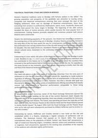
Twelve pages document titled: ''Theatrical traditions - stage and screen in Bendigo. The document details the history of theatres in Bendigo from the early days. Paragraphs titles are: The Shamrock Hotel, The Criterion Theatre, Abbott's Lyceum, St. James Hall, The Royal Princess Theatre, The Masonic Theatre, Open air picture Theatres, The Lyric Theatre, Plaza Theatre, Eaglehawk pictures. The Golden drive-in Picture Theatres in decline, Contemporary cinemas, Community traditions, Bendigo Regional Arts Centre, Ulumbarra Theatre. The document was prepared for the Post Office Gallery exhibition and is marked Confidential.entertainment, theatre, post office gallery -
 Bendigo Historical Society Inc.
Book - H. A & S. R. WILKINSON COLLECTION: SHARE REGISTER BOOK
Leather bound share register book. On the front inside page a note in pencil: given by Cath Ferguson - Balmoral Drive - 03/07/1998 to James Lerk, also a stamp McDonald's Reefs Gold Mining Company No Liability. The book has 243 pages the first 56 pages are cut. Company recorded in the book are: New Charscharlton (?), New Chum Syncline, Central Napoleon, Ironbark South, Central Deborah. South Virginia, New Don, Castley Syndicate, Napoleon Reefs, Deborah Limited. The book covers the years from 1934 to 1940. -
 Greensborough Historical Society
Photograph - Digital Image, Pioneer Reserve 2014 -1, 21/05/2014
Pioneer Reserve, Greensborough is a small park on the corner of St Helena and Diamond Creek Roads. It is adjacent to the site of Greensborough's first bridge across the Plenty River, c. 1864 - 1960s. The shelter, viewing platform, retaining wall and entrance are built from the bridge's massive bluestone arched abutments dismantled between 1974 and 1983. Pioneer Reserve is historically significant for its formative association with noted local landscape designer Gordon Ford in 1968, and it is likely that remnant large field stones at the entrance drive to the Reserve remain from his design. Photograph by Marilyn Smith 2014.Digital copy of colour photograph. -
 Flagstaff Hill Maritime Museum and Village
Tool - Caulking mallet, Mid 19th to early 20th centuries
The subject item is a vintage Nautical Shipwrights Ship Boat Caulking Hammer Mallet, Unusual Small Size. These mallets were routinely used in the 1800s when ships were made of wood. This mallet was used with caulking irons to drive the oakum (caulk) between the ship's bottom planking to seal them up. The mallet has slots to dampen the vibration of the mallet blows on the user's elbows. The head is made of a very hard wood, possibly Lignum Vitae or another dark tropical wood. The item seems to be of a very early design with the two preened-over metal rods for reinforcing the head. Item appears to be of early manufacture by an unknown maker from the mid to late 19th century and is significant as tools of this era are quite rare. This tool is also significant as it gives an insight into how ships made of wooden planks were made sea-worthy by inserting caulking material between the boards thereby making the vessel watertight. Caulking Mallet Wooden with iron ferrules on each end. Wooden head with two large bolts passing through body. Stamped W Milne. James S Steele tool box.Stamped W Milne & James S Steele tool box.mallet, flagstaff hill, warrnambool, flagstaff hill maritime museum, maritime museum, shipwreck coast, flagstaff hill maritime village, great ocean road, caulking mallet, caulking, james steele, shipwrights tools -
 Orbost & District Historical Society
shields - blackout, Swan, Wally, WW11
By 1941, the threat of Japanese invasion caused restrictions to daily life. Blackouts became the norm. To prevent identification from enemy planes all lights had to be turned down, including car headlights that had to be covered to minimize light exposure. In Australia more relaxed regulations led to the Australian air raid precautions being dubbed the “brownout”. These shields limited the amount of light emitted by a vehicle. To drive at night without them was an offence; however, the increase in road accidents led to the removal of headlight masks everywhere in Australia south of Rockhampton from 15 February 1943.These shields, though not rare, evoke a period of restrictions, fear, rationing and confinement.Pair of handmade car light blackout shields. Black round metal with scoop at front as well as small glass partition.shields-blackout ww11 transport-motor-vehicles -
 Warrnambool and District Historical Society Inc.
Artefact, Lister, Shearing heads, Early 20th century
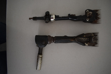
The woollen industry has always been of the utmost importance in Australia. Although exports have declined over the past decades the production of fine wool still remains important in our economy. The great increase in wool production in the mid to late 19th century in Australia led to the need to replace the hand shears with some mechanized form of shearing. The first sheep shearing machine in Australia was patented in 1867 and improvements to this early model were made over the ensuing years. The early 1890s saw the introduction of flexible drive shafts. The two items here described show this innovation. These two items are of interest as examples of handpieces used early in the 20th century in the mechanized shearing of sheep. They would be typical of the pieces used in the wool industry in the early 20th century in Western Victoria. There are today many local shearers living in Warrnambool and nearby towns and working in the district. .1 This is a metal handpiece for a sheep shearing mechanism. It has a toothed blade attached with metal screws at one end and a jointed metal pipe at the other end for attachment to the shearing machine. The middle section has been covered with black leather for easier gripping. .2 This is a metal handpiece for a sheep shearing mechanism. It has a toothed blade at one end and a flexible metal attachment at the other end to connect it to the shearing machine. Both items are rusted and stained. ‘Sunbeam Flight Lister’sheep shearing in the western district, warrnambool -
 Orbost & District Historical Society
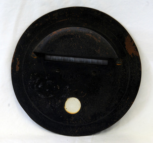
blackout shield, Lucas Industries, WW 11
By 1941, the threat of Japanese invasion caused restrictions to daily life. Blackouts became the norm. To prevent identification from enemy planes all lights had to be turned down, including car headlights that had to be covered to minimize light exposure. In Australia more relaxed regulations led to the Australian air raid precautions being dubbed the “brownout”. These shields limited the amount of light emitted by a vehicle. To drive at night without them was an offence; however, the increase in road accidents led to the removal of headlight masks everywhere in Australia south of Rockhampton from 15 February 1943. These shields, though not rare, evoke a period of restrictions, fear, rationing and confinement.A circular metal disc painted black - car light blackout shield. It has a small glass slot in front and a scooped out front to cover the light.ww11 blackout-shield -
 Eltham District Historical Society Inc
Photograph - Aerial Photograph, Landata, Research, Vic, Apr. 1963
Centred on present day Marconi Court, Research bounded by Maroondah Aqueduct to north, Thompson Crescent to south, Joselyn Drive to east and Eltham Research Oval to west. Historic Aerial Imagery Source: Landata.vic.gov.au Aerial Photo Details: Project No :486 Project : MELBOURNE (1963) PROJECT Run : 5 Frame : 62 Date : 04/1963 Film Type : B/W Camera : RC8 Flying Height : 5100 Scale : 9600 Film Number : 1805 GDA2020 : 37°42'24"S, 145°10'43"E MGA2020 : 339434, 5825157 (55) Melways : 22 F3 (ed. 42)aerial photo, neil webster collection, 1963-04, joselyn drive, marconi court, melway 22f3, research (vic.), research oval, thompson crescent -
 Eltham District Historical Society Inc
Photograph - Aerial Photograph, Landata, Research, Vic, Apr. 1972
Centred on present day Maroong Drive, Research bounded by Allendale Road to north, Thompson Crescent to south, Eltham College to east and Parsons Road to west. Historic Aerial Imagery Source: Landata.vic.gov.au Aerial Photo Details: Project No :985 Project : MELBOURNE 1972 Run : 26 Frame : 193 Date : 04/1972 Film Type : B/W Camera : RC10 Flying Height : 5700 Scale : 9600 Film Number : 2636 GDA2020 : 37°42'04"S, 145°10'33"E MGA2020 : 339187, 5825794 (55) Melways : 22 F1 (ed. 42)aerial photo, neil webster collection, 1972-04, allendale road, eltham, eltham barrel, eltham college, maroong drive, melway 22f1, parsons road, research (vic.), thompson crescent -
 Eltham District Historical Society Inc
Photograph - Aerial Photograph, Landata, Montmorency, Vic, Apr. 1972
Centred on present day Olympic Avenue at Grand Boulevard, Montmorency bounded by Meruka Drive to north, Main Road to south, Main Road to east and Alban Street to west. Historic Aerial Imagery Source: Landata.vic.gov.au Aerial Photo Details: Project No :985 Project : MELBOURNE 1972 Run : 28 Frame : 206 Date : 04/1972 Film Type : B/W Camera : RC10 Flying Height : 5700 Scale : 9600 Film Number : 2635 GDA2020 : 37°43'21"S, 145°07'46"E MGA2020 : 335154, 5823329 (55) Melways : 21 E7 (ed. 42)aerial photo, neil webster collection, 1972-04, eltham, alban street, grand boulevard, lower plenty, main road, melway 21e7, meruka drive, montmorency, olympic avenue -
 Melbourne Tram Museum
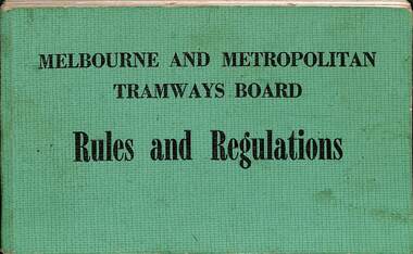
Book, Melbourne & Metropolitan Tramways Board (MMTB), "Rules and Regulations", 1974
Provides rules for both tramway and motor bus operations, has index pages 3 to 28, rules for both systems and specific type of vehicle, ticket machines and ticket issuing. At rear is MMTB By-Law 11 and By-Law, the latter dated 1956. Issued to F Reale-Key who worked for the Civil Engineering at South Melbourne Depot. Section of the MMTB or The Met and was authorised to drive trams. Dated Nov. 1974. For a photo of Frank standing in front of tram 8, see "MetLines - Vol 1, No. 9 December 1985". See Item 82 for a full scan of the document.Demonstrates the Rules and Regulations issued to drivers and to those authorised to drive trams or buses.Book - green Rexine covers, 106 pages with title - "Melbourne and Metropolitan Tramways Board - Rules and Regulations". Six sections, sewn into covers, dated Nov. 1974. See image i2 for details.tramways, trams, mmtb, the met, drivers, training, south melbourne depot, civil engineering department, instructions, rules, regulations -
 Ballarat Clarendon College
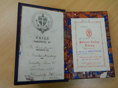
Book, A voyage round the world
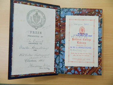
This book was awarded by Geelong Grammar to Walter Armstrong in 1881. It was donated to the Ballarat College library by his grandson W Mick U Armstrong (1944). Mick attended Ballarat College 1937 - 1942. In 1936 the Weatherly Library was established at Ballarat College and a community book drive resulted in personal copies of books owned by members of the school community being donated to the library over the next 10-20 years. Mick Armstrong donated this book (amongst others) to the school library during his final year at the school. It is an excellent example of the community spirit which carried the school through periods of financial hardship. Dark royal blue leather bound book with gold crest, borders and spine detail. Spine has 6 decorative compartments with raised bands and red leather and gold lettering in the title compartment; Geelong Grammar crest embossed in gold on front cover and gold border to front and back cover; marbled endpapers and edges; black and white frontispiece and illustrations throughout book; book plates inside front cover.Book plate inside front cover: Geelong Grammar crest / PRIZE / PRESENTED BY / The Headmaster / AWARDED TO / Walter Armstrong / FOR / Industry - Lower VI / Christmas 1881 / Bracebridge Wilson M A / Headmaster Book plate on right side of end paper: Ballarat College crest / Ballarat College / Library / PRESENTED BY / W M U Armstrong / W M Armstrong 1942 / Books may be kept for one week / only but may be renewed / PLEASE REPORT ANY LOOSE / LEAVES, ETC.walter-armstrong, w-m-u-armstrong, geelong-grammar -
 Ballarat Clarendon College
Book, Evidence of the truth of the Christian religion
This book was awarded by Geelong Grammar to Walter Armstrong in 1884. It was donated to the Ballarat College library by his grandson W Mick U Armstrong (1944). Mick attended Ballarat College 1937 - 1942. In 1936 the Weatherly Library was established at Ballarat College and a community book drive resulted in personal copies of books owned by members of the school community being donated to the library over the next 10-20 years. Mick Armstrong donated this book (amongst others) to the school library during his final year at the school. It is an excellent example of the community spirit which carried the school through periods of financial hardship. Dark royal blue leather bound book with gold crest, borders and spine detail. Spine has 6 decorative compartments with raised bands and red leather and gold lettering in the title compartment; Geelong Grammar crest embossed in gold on front cover and gold border to front and back cover; marbled endpapers and edges; black and white frontispiece and illustrations throughout book; book plates inside front cover.Book plate inside front cover: Geelong Grammar Crest / 1st PRIZE / PRESENTED BYB/ The Council / AWARDED TO / Walter Armstrong / FOR / Old & New testament / Middle 6th form / Christmas 1884 / Bracebridge Wilson / HEAD MASTER Book plate on front end page: Religion 200 / Ballarat College crest / Ballarat College / Library / PRESETNED BY / W M U ARMSTRONG 1942 / Books may be kept for One Week / only, but may be renewed / PLEASE REPORT ANY LOOSE / LEAVES, ETC. walter-armstrong, w-m-u-armstrong, geelong-grammar -
 Vision Australia
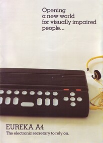
Functional object - Object, Robotron Pty Ltd, Eureka A4 electronic secretary, 1990s
The Eureka A4 was invented in Melbourne by Milan Hudacek, and designed to capitalise on the growth of IBM PCs. It attached to the PC and allowed blind and vision impaired people to utilise screen orientated programs. It had a sockets for telephone lines, a Braille keyboard, an inbuilt disk drive, speed and volume controls as as well outlets for data ports and headphones. The Royal Victorian Institute for the Blind (now a part of Vision Australia) received both the Eureka Award and the Qantas Rolls Royce Award in 1990 for its participation in the development and promotion of the Eureka A4 computer. It was the first computer of its kind, designed specifically for people who are blind or vision impaired.1 black rectangular box with grey and orange keys with advertising leafletSerial no: 1897braille equipment, assistive devices, milan hudacek -
 Eltham District Historical Society Inc
Photograph - Aerial Photograph, Landata, Eltham / Research, Vic, Jan. 1951
Centred on Brinkkotter Road opposite Yarramie Reserve, Eltham bounded by Maroondah Aqueduct to north, Nyora Road to south, Eltham College to east and Leane Drive to west. Historic Aerial Imagery Source: Landata.vic.gov.au Aerial Photo Details: Project No :65 Project : MELBOURNE AND METROPOLITAN PROJECT NO. 2 Run : 7 Frame : 8 Date : 01/1951 Film Type : B/W Camera : EAG9 Flying Height : 12200 Scale : 12000 Film Number : 1419 GDA2020 : 37°42'32"S, 145°10'41"E MGA2020 : 339408, 5824924 (55) Melways : 22 F3 (ed. 42)Historical aerial photos and photo maps provide viusal evidence of the chronology of changes to the built landscape of the district and assist in dating other imagesaerial photo, 1951-01, eltham, neil webster collection, brinkkotter road, eltham college, leane drive, maroondah aqueduct, melways 22f3, nyora road, yarramie reserve -
 Eltham District Historical Society Inc
Photograph - Aerial Photograph, Landata, Eltham, Vic, Jan. 1951
Centred on Beard Street between Main Road and Frank Street, Eltham bounded by Maroondah Aqueduct to north, Arthur Street to south, Maroong Drive to east and Catholic Ladies College to west. Historic Aerial Imagery Source: Landata.vic.gov.au Aerial Photo Details: Project No :65 Project : MELBOURNE AND METROPOLITAN PROJECT NO. 2 Run : 7 Frame : 9 Date : 01/1951 Film Type : B/W Camera : EAG9 Flying Height : 12200 Scale : 12000 Film Number : 1419 GDA2020 : 37°42'23"S, 145°09'39"E MGA2020 : 337874, 5825170 (55) Melways : 22 B3 (ed. 42)Historical aerial photos and photo maps provide viusal evidence of the chronology of changes to the built landscape of the district and assist in dating other imagesaerial photo, 1951-01, eltham, neil webster collection, arthur street, beard street, catholic ladies college, frank street, main road, maroondah aqueduct, maroong drive, melway 22b3, research (vic.) -
 Eltham District Historical Society Inc
Photograph - Aerial Photograph, Landata, Eltham North, Feb. 1956
Centred on present day 54 Kelway Crescent, Eltham North bounded by Glen Gully Road to north, Meruka Drive to south, Eltham College to east and Leach Street to west. Historic Aerial Imagery Source: Landata.vic.gov.au Aerial Photo Details: Project No :250 Project : MELBOURNE OUTER SUBURBS PROJECT Run : 17 Frame : 113 Date : 02/1956 Film Type : B/W Camera : EAG9 Flying Height : 10000 Scale : 12000 Film Number : 1176 GDA2020 : 37°42'16"S, 145°08'08"E MGA2020 : 335650, 5825336 (55) Melways : 21 G2 (ed. 42)aerial photo, 1956-02, eltham, eltham north, glen gully road, leach street, main road, melway 21g2, meruka drive, montmorency, neil webster collection