Showing 1507 items matching " land purchases"
-
 Flagstaff Hill Maritime Museum and Village
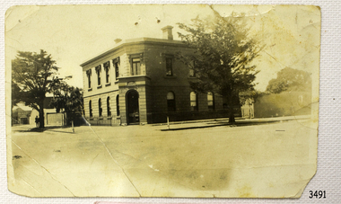
Photograph - Building, Bank of Australasia Warrnambool, ca. 1860
This sepia coloured photograph show the image of the former Bank of Australasia in Warrnambool. The two-storey building was built for the bank on the corner of Timor and Kepler Streets and opened there for business in 1860. It is now one of the City's Historic Buildings. The Bank of Australasia was incorporated by Royal Charter of England in March 1834. It came to Australia on 14th December 1835, opening in Sydney. The Acting Superintendent of the Bank of Australasia in Sydney at that time was David Charters McArthur. He was Superintendent from 1867-to 1876. The Melbourne branch of the Bank of Australasia opened on 28th August 1838 in a two-roomed brick cottage on the north side of Little Collins Street. Two huge mastiff dogs were kept in the backyard and let loose at night to guard the bank. The government also provided an armed military sentinel. Due to the bank's rapid growth, a new building for the Melbourne branch was opened in 1840 at 75 Collins Street West. By 1879 the bank had been upgraded to a magnificent two-storey building on the corners of Collins and Queens Streets, with the entry on Collins Street. In 1951 the Bank of Australasia amalgamated with the Union Bank to form the Australia and New Zealand Bank, now known as the ANZ. Then in 1970, the ANZ merged with both the ES&A and the London Bank of Australia to form the ANZ Banking Group Limited. The ANZ Banking Group Ltd kindly donated a variety of historic items from the Bank of Australasia. BANK of AUSTRALASIA, WARRNAMBOOL – In 1854 Warrnambool had two banks, the Union Back and the Bank of Australasia. Later, completely different bank businesses opened; in 1867 the National Bank of Australasia, then in 1875 the Colonial Bank of Australasia. The original Warrnambool branch of the Bank of Australasia was established in July 1854, and operated from a leased cottage on Merri Street, close to Liebig Street. The bank later bought a stone building previously erected by drapers Cramond & Dickson on the corner of Timor and Gibson Streets. Samuel Hannaford was a teller and then Manager at the Warrnambool branch from 1855 to 1856 and the Warrnambool Council chose that bank for its dealings during 1856-57. In 1859 Roberts & Co. was awarded the contract to build the new Bank of Australasia branch for the sum of £3,000. The land was on a sand hill on the northeast corner of Timor and Kepler Streets and had been bought in 1855 from investor James Cust. The new building opened on May 21, 1860. The bank continued to operate there until 1951 when it merged with the Union Bank to form the ANZ Bank, which continued operating from its Liebig Street building. Warrnambool City Council purchased the former Bank of Australasia building in 1971 and renovated it, then on 3rd December 1973 it was officially opened as the Art Gallery by Cr. Harold Stephenson and Gallery Director John Welsh. The Gallery transferred to the purpose-built building in Liebig Street in 1986 and the old bank building is now the Gallery club. Staff at the Bank of Australasia in Warrnambool included the following men but others were also involved: Samuel Hannaford, Teller then Manager from 1855-1856; W H Palmer, Manager from January 1857 until November 1869 when the Teller Basil Spence was promoted to Manager; H B Chomley, Manager from April 1873 and still there in 1886; A Butt, Manager in 1895-1904; J R McCleary Accountant and Acting Manager for 12 months, until 1900; A Kirk, Manager 1904; J Moore, staff until his transfer to Bendigo in December 1908; J S Bath was Manager until 1915; C C Cox, Manager until April 1923; Richard C Stanley, Manager 1923 to April 1928. The photograph is significant historically for its connection with the Bank of Australasia. The early Australian bank was established in 1834 by Royal Charter and opened in Sydney, Australia, in Sydney in 1835. The bank had many Australian offices in November 1877, particularly on the east and south coasts. Victoria had 45 percent of all Offices. The photograph has local historical significance for its association with the Warrnambool Bank of Australasia, which was established early in Warrnambool's history. It was Warrnambool Council’s first bank. The bank continued to operate until the organisation's merger in 1951 when it became the ANZ Bank Group of today. The Bank was an integral part of the growth of local commerce and the community.Black and white (or sepia) rectangular photograph, landscape orientation. Image of a two-storey building on a street corner. It is the former Bank of Australasia, Warrnambool, on the corner of Timor and Kepler Streets that was built in 1860. The reverse has a round, serrated-edged red label with an inscription, covered in opaque tape, plus four lines of handwritten text. There are several pin holes through the photograph.Label with: "AH2 2 / W.BOOL" Writing in pen: "D. K. Frew / --- / ---- / ----"flagstaff hill, warrnambool, shipwrecked coast, flagstaff hill maritime museum, maritime museum, shipwreck coast, flagstaff hill maritime village, great ocean road, bank of australasia, boa, union bank, australia & new zealand bank, anz bank, david charters mcarthur, d c mcarthur, commerce, banking, samuel hannaford, w h palmer, basil spence, h b chomley, a butt, j r mccleary, a kirk, j moore, j s bath, c c cox, richard c stanley, historic building, roberts & co., james cust, bank of australasia warrnambool -
 Phillip Island and District Historical Society Inc.
Photograph Album, Kodak, Phillip Island Cemetery, c 1990
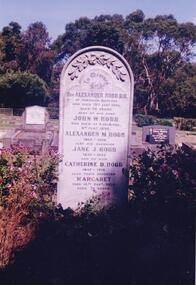
The Album was compiled by Nancy McHaffie late 1990's, with the assistance of Edith Jeffery's, with her book "Garden of Memories" and extensive knowledge of Phillip Island. The Cemetery lies back from the road and is surrounded by Manna Gums, rare Peppermint Gums, Blackwoods and other native trees. In all 25 acres of land were set aside as Crown Land in the land settlement of 1868. There are 6.2 acres of wetlands near the cemetery entrance.466-38: Rev Alexander Robb, DD. Rev Robb had been a missionary in Old Calabar and Jamaica and was the first minister of the Cowes Presbyterian Church from 1890-1901. Services were also held in the Public Hall at Rhyll. A daughter, Kathleen, like her parents, is buried in the cemetery. Kathleen was married to Harry West. 466-39: James Hill. Jimmy, as he was fondly called, came to Phillip Island in 1920 and purchased the Hotel, known as Woods Family Hotel (later the Phillip Island Hotel in Walpole Street). A milestone occurred whilst in his capable hands he installed an electric light plant, (32 volts), the first on the Island. He also made hundreds of cement bricks with which he built his own home. He died in 1937 aged 68. His only child Dorothy Edhouse aged 98, is also buried with her father.phillip island cemetery, james hill, rev alexander robb, nancy mchaffie, edith jeffery -
 Phillip Island and District Historical Society Inc.
Photograph Album, Kodak, Phillip Island Cemetery, c 1990
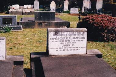
The Album was compiled by Nancy McHaffie late 1990's, with the assistance of Edith Jeffery's, with her book "Garden of Memories" and extensive knowledge of Phillip Island. The Cemetery lies back from the road and is surrounded by Manna Gums, rare Peppermint Gums, Blackwoods and other native trees. In all 25 acres of land were set aside as Crown Land in the land settlement of 1868. There are 6.2 acres of wetlands near the cemetery entrance.466-44: Captain Johan Jansson. Capatain Jansson was born in 1862 and came to Australia on the ship "Nosstaljee" in 1886. In 1887 he came to the Island and started work with Captain Lock. He bought land at Rhyll in 1891 and built a house two years later, now known as Jansson's Cottage. Johan married Evelyn Power.. a daughter of Captain Powell. He purchased the ketch "Swan" and later :Stephen" in 1914. They took chicory, seaweed, hay and other farm produce to Melbourne, returning with general cargo. Captain Jansson died in 1928 aged 66 years. 466-45: Evelyn Jansson. Evelyn was the daughter of Captain Powell. She married Johan Jansson on her 18th birthday. She died 1971 aged 95 years. Their daughter Mavis is buried with Evelyn - died 1971 aged 72 years.phillip island cemetery, johan jansson, evelyn jansson, mavis jansson, nancy mchaffie, edith jeffery -
 Phillip Island and District Historical Society Inc.
Photograph Album, Kodak, Phillip Island Cemetery, c 1990
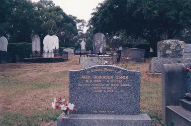
The Album was compiled by Nancy McHaffie late 1990's, with the assistance of Edith Jeffery's, with her book "Garden of Memories" and extensive knowledge of Phillip Island. The Cemetery lies back from the road and is surrounded by Manna Gums, rare Peppermint Gums, Blackwoods and other native trees. In all 25 acres of land were set aside as Crown Land in the land settlement of 1868. There are 6.2 acres of wetlands near the cemetery entrance.Jack Robinson Oswin: Many of the trees now flourishing in the cemetery grounds were planted by Jack Oswin and his wife Coral. Born in Mildura in 1909, his association with Phillip Island started when he attended the Cowes Primary School during the war years. He was foundation member of the Phillip Island Conservation Society and played a key role in the purchases of the area of land known as Conservation Hill. In the early 1980s he was awarded the British Empire Medal in recognition for his services to conservation. Jack died on December 4th 1990, aged 81 years.phillip island cemetery, jack robinson oswin, coral oswin, nancy mchaffie, edith jeffery -
 Phillip Island and District Historical Society Inc.
Book, Bill Hampel, Against the grain : fourteen farmers adapt to climate change, 2015
Can we humans simply ignore the fires, the floods, and the increase in deaths brought about by climate change? In this book, Australian farmers - who bear the brunt of climate change, yet accept the science - share their experiences with the unpredictable weather events, the reduction in rainfall, and the shift to hotter months which are a challenge to farming cycles. Far from contributing to the problem with their farming practices, these farmers demonstrate how to reduce their greenhouse gases - to zero or below in some cases - while remaining profitable. They are all committed to pass on their farm in a better condition than when they first purchased or inherited it. With crops or livestock, big or small, they have worked cooperatively, mostly through land management, to plant thousands of trees, which has led to the daily presence of over 100 bird species. The farmers' inspiring and informative stories will open up a new world to most urban dwellers. A summary of climate change impacts - and an account of the numerous economic, political, and media barriers toward change - combine to provide a context for their work. 280 pages : colour illustrations, colour maps, colour portraits ; 23 cm. Includes bibliographical references and index. Also available in digital formats: ebook & epdf. ISBN 9781925078503 Dewey number 338.10994 Chapter 5 : Bob & Anne Davie Donor : Anne Davie ; Date : 14.10.2015.agriculture -- environmental aspects -- australia., farmers -- australia -- economic conditions., rural development -- australia., climatic changes -- australia. -
![Newspaper Clipping - Digital Image, 2000 [pounds] for public open space 1965, 05/11/1965](/media/collectors/4f729f5697f83e03086015b8/items/5eb3933621ea670b94e21892/item-media/5eb3938a21ea670b94e2e147/item-fit-380x285.jpg) Greensborough Historical Society
Greensborough Historical SocietyNewspaper Clipping - Digital Image, 2000 [pounds] for public open space 1965, 05/11/1965
In 1965, the Board of Works advised Eltham Council that it had purchased 1 1/2 acres of land adjoining the Plenty River off Para Road zoned for public open space and offered the land to Council.An example of developments in the Greensborough area during the 1960sNews clipping, black and white text.shire of diamond valley, para road greensborough, melbourne and metropolitan board of works, plenty river, shire of eltham -
 Greensborough Historical Society
Folder, Peter Simmenauer, Partington land, edited by Peter Simmenauer, 1850-1950
Folder of documents relates to ownership of Crown Portion 13, Parish of Nillimbuk, County of Evelyn, purchased by John Alison in 1840 and sold to various people including Charles Partington Snr in 1878. It includes Certificates of Title recording transfers to Charles' children, and details of the land retained by Charles Jnr and Joseph Partington until their deaths in 1932 and 1943 respectively. A list of sales of allotments in the "Greenhills Estate" is also included.Folder of documents including Certificates of Title and other land documentsjohn alison, charles partington, charles partington junior, joseph partington, greenhills, partington family, greensborough, willis vale -
 Greensborough Historical Society
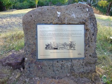
Photograph - Digital Image, Happy Hollow plaque, 05/02/1840o
The land surrounding Happy Hollow farm at Plenty was purchased by Francis Wickham in 1840. The land was later subdivided and held by various owners including Charles Partington (1875) and John McLaughlin who leased the property in 1892 to Robert Emmett Whatmough who erected the first dwelling on the property. The land was later owned by Mrs Betty Bell and was purchased by Parks Victoria in 1994 to form part of the Plenty Gorge Parklands. This plaque was laid by Plenty Historical Society.Happy Hollow was an example of early settlement along the Plenty River.Digital copy of colour photograph. Plaque at Plenty Gorge Parklands.plenty river, happy hollow, happy hollow farm, robert emmett whatmough, betty bell, john mclaughlin, charles partington, parks victoria -
 Greensborough Historical Society
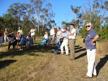
Photograph - Digital image, Happy Hollow plaque unveiling 1 and 2, 24/10/2006
Photograph of descendants of past owners of Happy Hollow preparing to unveil the commemorative plaque. Includes descendants of Charles Partington, John McLaughlin and Robert Emmett Whatmough. The land was later owned by Mrs Betty Bell and was purchased by Parks Victoria in 1994 to form part of the Plenty Gorge Parklands. This plaque was laid by Plenty Historical Society. Digital copy of colour photograph.happy hollow, robert emmett whatmough, charles partington, betty bell, parks victoria -
 Greensborough Historical Society
Photograph - Digital image, Unveiling Happy Hollow plaque, 24/10/2006
Photograph of descendants of past owners of Happy Hollow unveiling the commemorative plaque. Includes descendants of Charles Partington, John McLaughlin and Robert Emmett Whatmough. The land was later owned by Mrs Betty Bell and was purchased by Parks Victoria in 1994 to form part of the Plenty Gorge Parklands. This plaque was laid by Plenty Historical Society. Digital copies of 3 colour photographs.happy hollow, plenty river, john mclaughlin, charles partington, robert emmett whatmough, parks victoria -
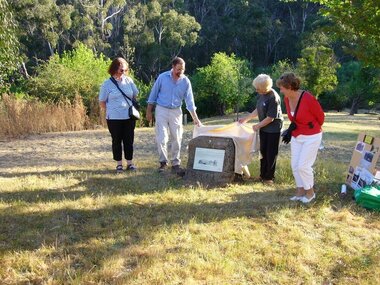
 Greensborough Historical Society
Newspaper clipping, Victorian Baptist Witness, Memory and hope at Strathalan, 1995_03
Review and extracts from "Memory and Hope", an 87 page history of Strathalan Baptist Home for the aged, by Damian X. Powell, from purchase in 1906/7 of the Strathalan homestead and 15 acres of land in Macleod by the Victorian Baptist Union to 1958 when further development of the site was halted.1 page, text and black and white images.strathalan baptist home for the aged, macleod -
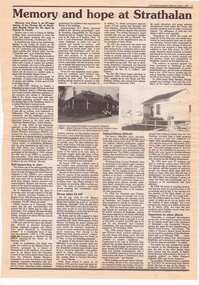
 Greensborough Historical Society
Newspaper - Newspaper Clipping, Heidelberg Leader et al, Greensborough site for Batman "treaty": author, by Rick Koenig, 2017_02
... of Batman's Treaty with aboriginal elders regarding purchase... regarding purchase of the land of Melbourne is not true. He claims ...Jim Poulter's research indicates that the accepted account of Batman's Treaty with aboriginal elders regarding purchase of the land of Melbourne is not true. He claims the Treaty was signed in Greensborough.Newspaper clipping, text and images. Date written in black ink: "Feb 2017"john batman, batmans treaty -
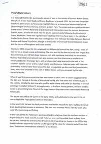 Greensborough Historical Society
Document, Judith Dodd?, Peck's Dam history, 1900o
History of a parcel of land bounded by Bolton Street, Brougham Street, Main Road and Grand Boulevard purchased by Mr Orr around 1900. It may have been called Panorama Heights Estate, Montmorency Park and later, Orr's Park. Orr had a dam made, which was called Peck's dam by locals in the 1940s-1950s.2p. typescriptorrs park, montmorency, pecks dam -
 Greensborough Historical Society
Hat, Medhurst Wines, Yarra Valley, 2016_
This hat was purchased at Medhurst Wines, Yarra Valley, as a gift for Faye Fort, who is a descendant of the Medhurst family. After leaving Greensborough, the Medhurst family moved to Gruyere in the Yarra Valley. They farmed the land that is now the vineyard that bears their name.Black polyester cotton sun hat with company logo in white stitchingLogo: "Medhurst Wines Yarra Valley"medhurst family, medhurst wines yarra valley -
 Glenelg Shire Council Cultural Collection
Souvenir - Souvenir Wooden Bowl, c. 1958
The Edina was one of the longest serving steam vessels anywhere in the world. Built on the Clyde by Barclay, Curle & Co. she was an iron hull single screw steamer of 322 tons with three masts. In 1855 Edina was requisitioned by the Admiralty from her owners the Leith, Hull & Hamburg Steam Packet Co. to carry stores and horses to the Black Sea during the Crimean War. After return to her owners Edina traded around the UK and Mediterranean before being purchased and used as a blockade runner during the American Civil War carrying cotton from the Confederate states in 1861. Edina arrived in Melbourne under sail in March 1863 and was purchased by Stephen Henty for use from ports in western Victoria and later carried gold prospectors across the Tasman to New Zealand. After a refit in 1870 she was used in the coastal trade along the Queensland coast for Howard Smith until returning to Victoria and the Melbourne-Geelong trade as a cargo-passenger vessel. She was taken out of service in 1938 but was later renamed Dinah and used as a lighter until 1958 when she was broken up and her remains used as land-fill.Small round shallow wooden bowl, 9 cm diameter with small brass plate attached wit two small brass tacks to the inner rim. Inscription 'MADE FROM THE WOOD OF S.S. EDINA''MADE FROM THE WOOD OF S.S. EDINA'souvenir, ss edina, shipwreck -
 City of Moorabbin Historical Society (Operating the Box Cottage Museum)
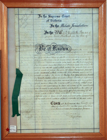
Document - Will of Elizabeth Avis-Box 1914, 1914
Elizabeth Avis- Box 1835-1913 was born in Sussex, married William Box in 1854 and arrived in Melbourne in 1855. William’s parents George and Mary Box and his siblings sailed with them. William & Mary at first leased land in the area of the ‘Dendy Special Survey Brighton 1841’ and then purchased the property with the pioneer cottage 1868 & 1869. William & Elizabeth established a market garden and raised 13 children. 1888 they built a larger 2nd house in front of the original cottage. William died in 1902 and Mary sold 9 acres in 1908 to W. .Snowden Anderson – it later became Joyce Park where the reconstructed Box Cottage Museum now stands. After Elizabeth died her daughters Ada and Violet lived on the 1 acre property until 1917 when August Reitman, a potter and monumental mason, leased the house and land. He established his pottery business and purchased the property in 1935. The business moved in 1953 but continued to use the cottage as a workshop/ storeroom until it was sold to Lewis Timber P/L in 1970. Elizabeth & William Box settled in the pioneer Cottage in Jasper Road East Brighton 1868 and established a market garden whilst raising their 13 children. This Cottage was reconstructed in Joyce Park, Ormond 1984 and is the home of City of Moorabbin Historical Society. In 1960 many local residents responded to a call for the donation of historical artefacts and the Box Cottage Museum now preserves this eclectic collection for the community.The original Last Will & Testament of Elizabeth Avis Box September 1914In the Supreme Court / of Victoria / In the Probate Jurisdiction / In the Will of Elizabeth Box late of / Jasper Road Bentleigh in the State of / Victoria Widow deceased. Be it known ............. Given at Melbourne this ( 21st September 1914) Signed A Carter / Registrar top left corner 79637 / Snowball ( X232) Bottom left corner 10/9/...box elizabeth, box william, moorabbin, bentleigh, brighton, ormond, pioneers, market gardeners, box george, box mary cripps, reitman august, anderson w. snowden, joyce park ormond, box cottage museum dendy’s special survey brighton 1841, -
 City of Moorabbin Historical Society (Operating the Box Cottage Museum)
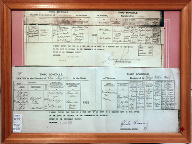
Document - Copy of Death Certificate Elizabeth Box 1914, 1914
Elizabeth Avis- Box 1835-1914 was born in Sussex, married William Box in 1854 and arrived in Melbourne in 1855. William’s parents George and Mary Box and his siblings sailed with them. William & Elizabeth at first leased land in the area of the ‘Dendy Special Survey Brighton 1841’ and then purchased the property with the pioneer cottage 1868 & 1869. William & Elizabeth established a market garden and raised 13 children. 1888 they built a larger 2nd house in front of the original cottage. William died in 1902 and Mary sold 9acres in 1908 to W. .Snowden Anderson – it later became Joyce Park where the reconstructed Box Cottage Museum now stands. After Elizabeth died her daughters Ada and Violet lived on the 1acre property until 1917 when August Reitman, a potter and monumental mason, leased the house and land. He established his pottery business and purchased the property in 1935. The business moved in 1953 but continued to use the cottage as a workshop/ storeroom until it was sold to Lewis Timber P/L in 1970 Elizabeth & William Box settled in the pioneer Cottage in Jasper Road East Brighton 1868 and established a market garden whilst raising their 13 children. This Cottage was reconstructed in Joyce Park, Ormond 1984 and is the home of City of Moorabbin Historical Society. In 1960 many local residents responded to a call for the donation of historical artefacts and the Box Cottage Museum now preserves this eclectic collection for the community. A certified true copy of the Death Certificate of Elizabeth Avis- Box 1835 -1914 in a wooden picture frame, obtained from The Births, Deaths and Marriages Office Melbourne Victoria 18/6/1985 THIRD SCHEDULE / DEATHS in the District of East Brighton in the State of Victoria Registered by George William Ward / Dated 1914 / 1st July 1914 Jasper Rd Bentleigh Shire of Moorabbin County of Bourke / Elizabeth Box / Home duties/ …… Dr A T Joyce Certified ‘true copy of an entry in a register’……… Signed by Paul Kenny Registration Officer 18 June 1985 box elizabeth avis, box william, moorabbin, bentleigh, brighton, ormond, pioneers, market gardeners, brighton cemetery, box george, box mary cripps, reitman august, anderson w. snowden, joyce park ormond, box cottage museum dendy’s special survey brighton 1841, -
 City of Moorabbin Historical Society (Operating the Box Cottage Museum)
Document, Death Certificate William Box 1902, 1985
William Box1834-1902 and Elizabeth Avis Box 1835-1913 came to Australia with his parents George and Mary Cripps-Box and siblings in 1856. Caroline Box, the eldest daughter of George and Mary Cripps-Box, remained in England working as a cook until she joined the family in Australia in 1863. William Box with his wife Elizabeth Avis Box at first leased market garden allotments in Brighton that was part of the Henry Dendy Special Survey 1841. In 1868 and 1869 they purchased 2 blocks with a pioneer’s cottage in Jasper Road East Brighton ( now Ormond / McKinnon ) where they established a market garden, built a 2nd house and raised 13 children. In 1908 Elizabeth sold most of the land retaining 1 acre with the dwellings in which she resided with her two daughters until her death 1913. The original pioneer cottage was reconstructed in 1984 and is known as Box Cottage Museum William & Elizabeth Avis- Box settled in the pioneer Cottage in Jasper Road East Brighton 1868 and established a market garden whilst raising their 13 children. This Cottage was reconstructed in Joyce Park, Ormond 1984 and is the home of City of Moorabbin Historical Society. In 1960 many local residents responded to a call for the donation of historical artefacts and the Box Cottage Museum now preserves this eclectic collection for the community. A certified true copy of the Death Certificate of William Box 1834 -1902 in a wooden picture frame, obtained from The Births, Deaths and Marriages Office Melbourne Victoria 1985 THIRD SCHEDULE / DEATHS in the District of East Brighton in the State of Victoria Registered by W. Ward Certified ‘true copy of an entry in a register’……… Signed by Paul Kenny Registration Officer 1985 box william, box elizabeth, brighton, moorabbin, cottages, pioneers, ormond, colonial, mckinnon, dendy henry, museums, box alonzo, market gardeners, box cottage museum -
 City of Moorabbin Historical Society (Operating the Box Cottage Museum)
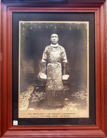
Photograph - Chinese Commissioner, Hwang Hong Cheng,1906, 1902
... of the Chinese workers did not purchase land instead their main aim ...His Excellency, Hwang Hon Cheng, from Peking, China, visited Australia from 1906 -1907 as Chinese Commissioner in response to an urgent petition from well respected Chinese business leaders, The 1906 Petition was sent to the Chinese Ambassador in Britain requesting the appointment of a Chinese Consular Representative in Australia to ease the escalating Discrimination and address the Immigration Restrictions in Australia. Hwang Hon Cheng visited Brisbane, Sydney, Melbourne , Adelaide and Hobart and after reviewing his recommendations Britain agreed to the appointment of the first Chinese Consul-General to Australia. In 1908 Mr Leong Lan Fun, Taotal of Swatow was appointed Consul-General for the Commonwealth with his headquarters in Melbourne. Animosity, suspicion and misunderstanding had existed between Chinese and European settlers since the Gold Rush of 1850’s. Language, customs, frugality and mostly their ability to obtain profit from crops seen as uneconomical by Europeans eg parsley, garlic and salad vegetables. Many of the Chinese workers did not purchase land instead their main aim was to obtain enough money for their family and return to China. There were a few still managing market gardens around East Bentleigh until the 1950’s, by which time they were highly regarded by the general community. A large photograph of His Excellency the Chinese Commissioner , Hwang Hong Cheng, in a wooden frame c1906His Excellency the Chinese Commissioner / Hwang Hong Cheng, moorabbin, bentleigh, ormond, brighton, gold rush, chinese immigration, chinese market gardeners, markets, cheltenham, cabinet makers, early settlers, pioneers, market gardeners, , hwang hon cheng, leong lan fun, peking china, melbourne -
 City of Moorabbin Historical Society (Operating the Box Cottage Museum)
Document, laminated List of Pioneers Moorabbin Parish, c1985
This list shows the names of the Pioneer settlers with the amount of Acres, the date purchased from The Crown and the Lot or Portion Number in the Land of the Henry Dendy Special Survey of Brighton 1841, in the County of Bourke , Victoria. The Squatters ,who arrived in the area first, used the land for grazing sheep and cattle. The Squatters had the right to graze unoccupied Crown land for ₤10 per year rental and a per capita payment for animals grazed. They could develop , improve and clear the land for the purpose of the tenancy but ownership was not permitted. When the land became useful The Crown put it on the market and the developers took over whilst the Squatters lost the improved land, dwellings and out buildings, there being no compensation paid. Squatters named John and Thomas Martin 1840-41; Richard and John King 1840- 1854 ; M.N.M.Moysey and M.J.Bickford 1841-1852 ; James McMahon 1846-1853 ; Daniel MacKinnon 1839- 1840. The 5120 Acres of the Henry Dendy Special Survey 1841were divided into approx. 83 Portions / Lots with varying acreage . Josiah Holloway, a speculator purchased 625 acres of the King Brothers run and re-sectioned the land into 2 acre Lots for Sale as market gardens. It was called The Two Acre Village later known as Cheltenham. A List of the names of The Pioneers in County of Burke Victoria c1841-1887 compiled by Lesley A. Schumer in 1985 A 3 Laminated display on wall in room 2 THE PIONEERS, Signed L.A. Schumer moorabbin, brighton, cheltenham, bentleigh, market gardeners, pioneers, early settlers, dendy henry, henry dendy's special survey 1841, squatters, king john, martin john, mcmahon james, two acre village, holloway josiah, were jonathan binn, grazing, cattle, sheep, market gardens, -
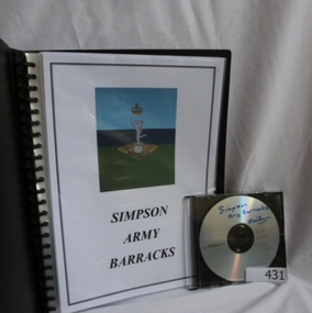 Greensborough Historical Society
Folder and compact disc, Simpson Army Barracks, 2011_
... land was purchased for the extension of the barracks ...This document is the result of research into the history of Watsonia Barracks (now Simpson Barracks) by GHS member Marilyn Smith. It details the origin of street names in the surrounding area and includes biographical information on those after whom the streets were named. Updated December 2016.The Watsonia Barracks has been in use since WW2 and is today home to the Defence Force School of Signals. It was built on the property formerly owned by Ainslie Meares. In 1951, surrounding land was purchased for the extension of the barracks. The suburb of Yallambie was formerly part of the Barracks. Black spiral bound folder (approx. 32 pages) with accompanying compact disc. Colour illustrations and maps. Updated 2016 in Word document.simpson army barracks, watsonia barracks, yallambie, marilyn smith, watsonia -
 Halls Gap & Grampians Historical Society
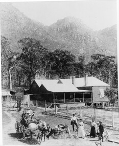
Photograph - B/W, C 1880
1880-1902 Land owned by Robert and Sarah Graham who owned a large portion of land best described as Upper Fyans Valley. At some time after 1880, they sold a parcel of the land under Sundial Peak to David Austin who built a slab hut. C1896, The land was sold to James and Amy Balmain which they named 'Bellfield' Amy was a daughter of John D/Alton who built the Stawell Water Supply System. Balmain purchased the vacant school cottage at Burnt Bridge and moved it to 'Bellfield' Over the next six years the house was enlarged to accommodate their growing family but sold in 1902 following the death of Amy Balmain.House with addition People leaving house by horse and carriage, people standing in groundsState Library Victoria, Rose's Australasian Views Victorian Series photographed and published by George Rose 123 Chapel St., Windsor, Victoriabuildings, houses, bellfield -
 Halls Gap & Grampians Historical Society
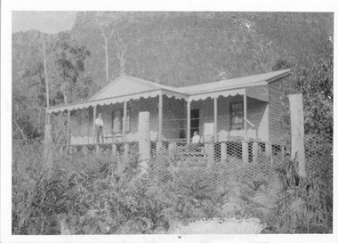
Photograph - B/W, C 1917
Land owned by William & Matilda Thompson. They purchased some disused shearers' quarters, consisting of six rooms, and in 1917 moved the building onto their land to provide a home. Mrs. Thompson had only recently retired after being the manageress of "Bellfield" for seven years. They named their house "Norval". Norval. Front view of house with a man and woman on verandah (un-named). Chicken wire fence in foreground.buildings, houses, norval -
 Halls Gap & Grampians Historical Society
Photograph - Sepia
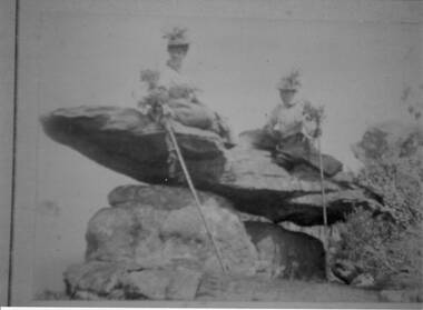
The name " Balmain " has been attributed to the photo, James Balmain and his wife, Amy Sophia [D'Alton} purchased a vacant school cottage from the area and moved it to their land and called it Bellfield. Amy died at age 37, James returned to Scotland with their 3 children.Photo shows 2 women sitting on a rock formation, both are wearing hats adorned with flowers and appear to be wearing long skirts and high buttoned blouses. They are both holding sticks which seem to be decorated with flowers,recreation, bush-walking -
 Kiewa Valley Historical Society
Black and White photograph of Road Making Machinery, Kiewa Road Making 25/08/1938 No. 2, 25/08/1938
Construction of the main road from South Tawonga to the Bogong High Plains, to provide access to the construction sites for the new Kiewa Hydro Electric Scheme, was commenced early in 1938, the work being undertaken on behalf of the commission by the Country Roads Board. For the construction work, the Commission purchased three Caterpillar - model R07 - diesel crawler tractors equipped with Kay Brunerei (Brunner) hydraulically operated trailbuilders (angle dozers). This acquisition resulted from a visit to the United States of America in May, 1937 by the Construction Engineer ( Mr. C.H. Kernot) and Assistant Civil Engineer ( Mr. J.F. Douglas) where they saw this relatively new type of equipment in use. With the co-operation of the CRB, the Commission demonstrated the operation of these machines at Fishermen's Bend on 6th April, 1938. They were then sent to Kiewa where they commenced operation towards the end of the month. From South Tawonga, the route let immediately across the Western Branch of the Kiewa River necessitating the construction of a bridge 100 feet long. By the end of 1939, the excavation had been 'opened up' for a distance of 19 1/2 miles (approx. 31 km.) and of this length, 10 miles (approx. 16 km.) had been surfaced. (see KVHS 0328)The purchase of this type of mechanical equipment in road making was a huge investment, as prior to this most of the work would have been done manually with the use of picks and shovels. Not only were many months of hard manual labour saved, but a very significant amount of time in providing access to the proposed work sites for the new Kiewa Hydro Scheme. This photo is an excellent reminder of how primitive the early machinery was compared to the present but also represents the forward thinking of the State Electricity Commissions engineers in purchasing such innovative equipment.A black and white photograph of road making near Mt. Beauty in 1938. Mount Beauty hills can be seen in the background with cleared land for grazing in the fore ground.Hand printed in black ink at the top of the photograph is 'Kiewa Road Making 25/8/1938'. On the right hand corner has been printed the number 2. It has been printed on gloss Velox paper.road making, state electricity commission, caterpillar tractor, kiewa, secv -
 Eltham District Historical Society Inc
Photograph, Entrance to Shire of Eltham Memorial Park, Garden Hill, Eltham-Yarra Glen Road, Kangaroo Ground, c.1923
... the purchase of the land. • The earliest public reference... the purchase of the land. • The earliest public reference ...View to south-east from Shire of Eltham Soldiers' Memorial Park showing the carriageway from the road to top of Memorial Park. Accompanying notes state that the entry gate was put in place in May 1921. Eltham and Whittlesea Shire Advertiser and Diamond Creek Valley Advocate Fri 21 May 1920 p 2 reported: Kangaroo Ground Memorial Park "It was decided to arrange for a working bee on Saturday, 29th inst., for the purpose of forming and gravelling the track leading to the Park, and of carrying out other necessary works." A history summary of the Shire of Eltham Soldiers’ Memorial Park • The summit at Garden Hill was a popular tourist lookout and picnic spot from the 1880s. Virtually the entire Shire of Eltham and beyond could be viewed from this location. • A local farmer, Mr Walter A. D. Wippell is credited as being the first to propose the idea of a war memorial park and offered £50 towards the purchase of the land. • The earliest public reference to this project is to be found in the local Advertiser newspaper edition of August 9th, 1918. A report of the August Council meeting records the Eltham Shire President, Cr. Robert White, saying: "some time back it was proposed that the Council obtain and place on an Honour Board in the Council Chamber [at Kangaroo Ground] containing names of the lads who had enlisted. Just recently however, it had been suggested that a more fitting memorial would be the obtaining of a piece of land on the summit of Garden Hill, Kangaroo Ground, and the formation of a memorial park in which a monument could be erected to represent the whole of Shire. If a couple of acres could be obtained a gentleman had promised to donate 50 pounds, and another one would fence it, and other contributions, he was sure, could be obtained." • Councillors were favourable of the proposal and the President, Shire Secretary and Shire Engineer were deputised to wait on Messrs Mess Bros. (the owners of the Garden Hill farm) and ascertain if they would gratuitously give the land. The Mess Bros. land adjoined the farm/stud of Mrs Fanny White (Cr Robert White’s mother), daughter of Andrew Harkness who established their property on Garden Hill around 1846. • Access to the land came in February 1919 when several Councillors and the Shire Engineer surveyed the actual two acres of '5 chains along the road and 4 chains deep'. The Engineer volunteered his services free to do this task. The Mess brothers however demanded £100 per acre but eventually agreed to take £50 per acre. • Entry from the Kangaroo Ground-Yarra Glen road was seen to be a problem and Mrs. White, who owned the land beside the park, was asked to donated a triangle of her property to allow this access. • By September 1919 returned soldiers were employed by the Shire and volunteers were called to clear the hilltop by ploughing up the rocks and clearing the area, the fencing was put into place and in May 1921 the Council erected three gates, within an archway, at the entrance to the drive and pathway to the summit. • Public subscriptions were sought through the Advertiser newspaper to beautify the site. The views of the Curator of the Melbourne Botanical Gardens were sought as to the ‘class of ornamental trees most suitable for planting in the Park area”. • The Memorial Park or Shire of Eltham Soldiers’ Memorial Park was officially opened by Mr. W.H. Everard, M.L.A., 3 September 1921. • In 1922 plans were made to place a War Memorial in the Park. Funds were donated by the Council of £250 and a challenge to the community, to match this money with contributions was met. • On Anzac Day 1923, 1,000 people gathered on the summit in the park for a memorial service. A much smaller group of about 50 people gathered around a newly constructed cairn and flagstaff in the afternoon of Anzac Day 1924 amidst rain and a squally southerly wind, the morning service being cancelled. • A meeting for those interested in establishing a War Memorial monument within the park was held in January 1924 and the Eltham Shire War Memorial League was formed and a design competition decided upon. • The Shire of Eltham War Memorial tower was built in 1926 at a cost of £1,023 and 5 shillings with locally quarried stone donated by Dr Ethel and Professor William Osborne. It was formally known as the ‘Shire of Eltham War Memorial’ and was unveiled on 11 November 1926. The large bronze inscription above the entrance to the tower states: SHIRE OF ELTHAM WAR MEMORIAL THESE MEN DIED FOR THEIR COUNTRY 1914 IN REMEMBRANCE THIS TOWER WAS BUILT 1918 • The Caretaker’s hut was built in 1927 with left over from the tower construction. • A returned soldier was appointed to act as caretaker for the memorials. Tiny Carrol, a huge man, was the first caretaker and lived in the stone hut. There was a push to have alterations made at one stage to provide additional rooms for a married caretaker but was rejected. • A new Caretaker Cottage was built in 1951 at a cost £2,500. The cottage had been subjected to raids by thieves three times during construction until a guard from the Returned Servicemen’s League was posted until its opening. • The War Memorial tower was re-dedicated by Sir Dallas Brooks on 8 November 1951, unveiling new bronze plaques containing the names of those who fell during the Second World War. Sir Dallas also officiated the opening of the new Caretaker’s Cottage. • A toilet block was built in 1965. • A further dedication of the Shire of Eltham War Memorial tower took place 11 November 2001 to recognise the men who fell in subsequent campaigns up to and including Vietnam. • Four land titles are involved: o The purchase of the two acres from owners Ruth Gosling, Alexander Mess, James Johnson Mess and Joseph Mess is recorded in two actions, the first being the payment of £100 for the two acres, the second showing that the Shire of Eltham did not get a transfer of title until 14th January 1952. o The access land donated by Mrs. Fanny White is dated 26 February 1924. A further need to widen the entry came after the deepening of the road cutting and another land donation was given by Sir Herbert Gepp, title dated 15th May 1952. This would have been about the time he sold off the former White ‘Garden Hill’ property. o The land reserve to increase the area and possibly allow a circuit road to be put in place on the western side of the park was purchased by the Shire of Eltham, title dated 16th February 1973. Rare photograph of the entrance to the Shire's Memorial Park during early stages of development prior to the erection of the Shire of Eltham War MemorialSepia photograph printed with white border with slight crack lower left hand corner and three significant vertical cracks fanning from lower centre edge to upper edge Digitally enhanced version to minimise impact of crackseltham-yarra glen road, entrance gate, garden hill, kangaroo ground, shire of eltham memorial park, shire of eltham war memorial, kangaroo ground war memorial park -
Eltham District Historical Society Inc
Folder, Ewen Cameron
... he purchased 80 acres of land at Kangaroo Ground, where he... for several years at the Caledonia gold diggings. In 1860 he purchased ...Cameron, Ewen Hugh, M.L.A.., J.P. Kangaroo Ground, is a native of Inverness-shire, Scotland, and came out to Victoria in the ship Hurricane, 13th September, 1853. After he had been engaged for two years int eh building trade in Melbourne in company with is two brothers, since dead, he carried on storekeeping for several years at the Caledonia gold diggings. In 1860 he purchased 80 acres of land at Kangaroo Ground, where he now resides, and later 160 aces of lands at Yarra Flats; he has also 600 acres rented, and is occupied in grazing and agricultural pursuits generally. Mr Cameron holds the prize given by the agricultural society for the best-kept farm in the district. In 1863 he was elected a member of the shire council, and has held the position to represent the Castlemaine mining board, which office he still holds, and in 1874, he was elected to a seat in the Legislative Assembly for the County of Evelyn, which seat he still retains, having the contested the constituency five times, and been elected once without opposition. from "Victoria and its Metropolis: Past and Present" written in 1888 by Alexander Sutherland. Chapter 19, "The Upper Yarra District" pages [402] - 415. Includes descriptions of some townships and short biographies of local residents. Page 405 Folder of information on Ewen Hugh Cameron, MP, Kangaroo Groundewen cameron, pigeon bank -
Eltham District Historical Society Inc
Folder, J.D. and E. Cameron, 1850s
... he purchased 80 acres of land at Kangaroo Ground, where he... for several years at the Caledonia gold diggings. In 1860 he purchased ...Cameron, Ewen Hugh, M.L.A.., J.P. Kangaroo Ground, is a native of Inverness-shire, Scotland, and came out to Victoria in the ship Hurricane, 13th September, 1853. After he had been engaged for two years int eh building trade in Melbourne in company with is two brothers, since dead, he carried on storekeeping for several years at the Caledonia gold diggings. In 1860 he purchased 80 acres of land at Kangaroo Ground, where he now resides, and later 160 aces of lands at Yarra Flats; he has also 600 acres rented, and is occupied in grazing and agricultural pursuits generally. Mr Cameron holds the prize given by the agricultural society for the best-kept farm in the district. In 1863 he was elected a member of the shire council, and has held the position to represent the Castlemaine mining board, which office he still holds, and in 1874, he was elected to a seat in the Legislative Assembly for the County of Evelyn, which seat he still retains, having the contested the constituency five times, and been elected once without opposition from "Victoria and its Metropolis: Past and Present" written in 1888 by Alexander Sutherland. Chapter 19, "The Upper Yarra District" pages [402] - 415. Includes descriptions of some townships and short biographies of local residents. Page 405 Folder of information on J D and E Cameron, land purchasers, Eltham, c.1850sj.d cameron -
 Warrnambool and District Historical Society Inc.
Book, Book Holy Bible, 19th century
This Bible was owned by Janet Hose (nee Murfitt) 1856-1947. She was married to George Hose and they lived in Warrnambool for all of their married life. They had eleven children and all the births and some of the deaths of the children are recorded in this little Bible. The book was purchased from James Hider who had been a carpenter, a land agent and a rate collector before he established a bookstore in Timor Street in the 1860s. He was heavily involved in community affairs, being a local Councillor and Mayor in 1868-9. He was also an early commercial photographer in Warrnambool. This small Bible is of great interest because of its connection to the Hose family in Warrnambool. In the book are recorded the births and deaths of members of the Hose family. It was a common custom in the 19th century to include family history details in family Bibles and some larger-style Bibles had pages specifically printed to include family history material. This Bible is also of antiquarian interest, an attractive item with its leather cover and gold clasp.This is a mottled brown leather-covered Bible of 840 pages. The pages are gilt-edged and there is a gold metal clasp to close over the pages. Inside the front and back pages there are signatures and other handwritten material, some written in black ink and some in pencil. There is also a label from the Warrnambool book shop and stationery store of James Hider. The inscription pages and the front cover are stained. The cover is also rubbed. ‘J.Hider Opposite the Post Office Warrnambool’ ‘Janet Hose 19/07, 78,83 (Plus the family history details of the Hose Family, mostly on the back pages) janet and george hose, history of warrnambool -
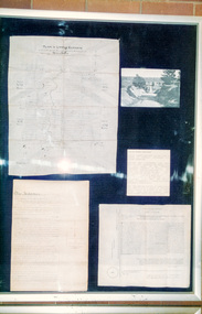 Eltham District Historical Society Inc
Photograph, Peter Bassett-Smith, 1852 Plan of Little Eltham and Land Purchase by Josiah Holloway, 1988
... 1852 Plan of Little Eltham and Land Purchase by Josiah... Eltham Colour photograph 1852 Plan of Little Eltham and Land ...Bicentennial/Heritage Week Display, "The Eltham Tradition", Eltham Shire Office, 17-22 April 1988 Colour photographactivities, eltham shire office, heritage display, heritage week, josiah holloway, little eltham