Showing 9839 items
matching 37
-
 Eltham District Historical Society Inc
Photograph - Aerial Photograph, Landata, Eltham, Vic, Apr. 1972
Centred on present day Mays Road at Stringybark Road, Eltham bounded by Nyora Road to north, Yarra River to south, Reynolds Road to east and Bible Street to west. Historic Aerial Imagery Source: Landata.vic.gov.au Aerial Photo Details: Project No :985 Project : MELBOURNE 1972 Run : 28 Frame : 209 Date : 04/1972 Film Type : B/W Camera : RC10 Flying Height : 5700 Scale : 9600 Film Number : 2635 GDA2020 : 37°43'33"S, 145°09'28"E MGA2020 : 337647, 5823013 (55) Melways : 22 B8 (ed. 42)aerial photo, neil webster collection, 1972-04, eltham, bible street, mays road, melway 22b8, nyora road, reynolds road, stringybark road, yarra river -
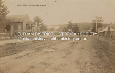 Eltham District Historical Society Inc
Postcard - Photograph postcard, Main Road, Greensborough, c.1910
View looking northeast along Main Street. The Greensborough Methodist Church stood at the present-day entrance to Greensborough Plaza shopping centre at 25 Main Street, Greensborough. It was opened in 1873. The Main Street Church served the congregation well, but by the 1960s it was decided to sell the old building and invest in a new home. The land at 37 Grimshaw Street for the current Uniting church was purchased in 1962 from the estate of Mrs White. Construction commenced on 31 July 1965 and the new church was opened on February 5, 1966. (https://www.churchhistories.net.au/church-catalog/greensborough-vic-uniting)Digital file only Postcards scanned from the collection of Michael Aitken on loan to EDHS, 2 Sep. 2022michael aitken collection, postcards, greensborough, main street, methodist church -
 Eltham District Historical Society Inc
Photograph - Aerial Photograph, Landata, Eltham, Main Road; Henry St to Bellevue Rd, Dec. 1945
Eltham, Main Road; Henry St to Bellevue Rd, and east along Luck St to present day Eltham East School Historic Aerial Imagery Source: Landata.vic.gov.au Aerial Photo Details: Project No :5 Project : MELBOURNE AND METROPOLITAN AREA PROJECT Run : 36 Frame : 60549 Date : 12/1945 Film Type : B/W Camera : EAG4 Flying Height : 10200 Scale : 6000 Film Number : 228 GDA2020 : 37°42'45"S, 145°08'59"E MGA2020 : 336903, 5824465 (55) Melways : 21 K4 (ed. 42)aerial photo, arthur street, bellevue road, bible street, diamond street, dudley street, elsa court, eltham, eltham east primary school, gahan house, henry street, livingstone road, luck street, main road, pryor street, neil webster collection -
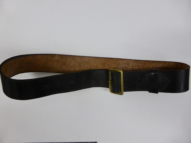 Warrnambool and District Historical Society Inc.
Clothing, Warrnambool Urban Fire Brigade Belt, Mid 20th century
This belt was worn with the jacket issued to members of the Warrnambool Fire Brigade in the mid 20th century. The jacket was part of the uniform that served both as a dress uniform and a work uniform. The Warrnambool Fire Brigade was formed in 1863 following unsuccessful attempts to establish a permanent fire service in the town. It was prompted by a fire at the Flying Buck Hotel in Liebig Street. The Warrnambool Fire Brigade, now located on the Mortlake Road, has been successful in Victorian Fire Brigade competitions and demonstrations, particularly in the 19th century. The owner of the belt and uniform was John (Jack) Sizeland, a member of the Warrnambool Fire Brigade for over 37 years. This belt is of interest as it was part of a Warrnambool Fire Brigade uniform during the second half of the 20th century. It also has individual local provenance as it belonged to Jack Sizeland, a member of the Warrnambool Fire Brigade who retired in 1977 after 37 years of service. This is a brown leather belt with a gold metal buckle and nine punched holes on the buckle, two of them hand-punched. It has a leather attachment to keep the belt end in place. It has the name of the owner, John Sizeland, written in biro on the inside of the belt. This belt is meant to be worn with the Warrnambool Fire Brigade jacket with the brass buttons. ‘J. Sizeland, W’bool’warrnambool fire brigade, jack sizeland, history of warrnambool -
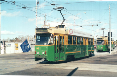 Melbourne Tram Museum
Photograph - Set of 6 colour prints of trams at Corner of Flinders and Swanston Streets, George Bishop, c1999
Set of six colour photographs of trams at the corner of Swanston and Flinders Streets. In the background can be seen the construction of the Federation Square project which commenced in 1999. 1 - Z 96 (Route 3, University) at Flinders and Swanston Streets. 2 - Z 37 (University route 5) 3 - SW6 888, City Circle, westbound. 4 - Z3 140 (East Coburg Route 1) - would appear that the car is not doing their hook turn properly 5 - B2 2037 westbound (Route 70, City Flinders St) 6 - Z 41 (Route 72, University)Yields information about the operation of Melbourne trams during the late 1990s.Set of six Colour prints printed on Kodak paperDetails of the photograph and photographer on the rear in ink.trams, tramways, z3 class, z class, tram 96, tram 37, city circle, tram 888, hook turns, tram 140, b2 class, tram 2037 -
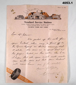 Bendigo Military Museum
Letter - LETTERS WW2, 2) 20.10.1940
Harold James Thomas Johnson TX3956 enlisted on 25.7.1940, aged 37. Served with the 7th Division Ammunition Supply Coy A.A.S.C as a driver. He was discharged om 30.11.1945 with the rank of L/Cpl. .1) Letter is to 'Dear Mrs Johnson". The contents of the note relate to the writer picking up the note which was thrown over the side of the Queen Mary and they picked it up form the water and later posted it on. .2) Note torn in half from "TX3956 B Section 7 DIV AMN COY 2nd AIF ABROAD" To "Mrs H. JOHNSON HOLLAND HOUSE WILMOT ST BURNIE TASMANIA, Husband on Queen Mary Everything okay, Love Harold". This is believed to be the note thrown overboard in .1). .3) The letter from H, Johnson is to "Brooks McGlashan & ?? PTY LTD", thanking them for parcels received VIA the Aust. Comforts Fund. Point .1) on the rear has three handwritten names in pencil: "TX3930, Thomas Charles Munn, 7th AFG Brighton" "TX3422, Pte. K.V. Smith 6th Rfts I.T.D Brighton" "30337 AC1 Sayer Group 37 - Ascot Vale" All three enlisted in 1940. Munn was discharged 23.6.1946 in 8 Div AASC Smith was discharged 12.11.1945 in 2/8 Fld Regt. Sayer was discharged 9.11.1945 in 7 AIRCRAFT Depot (RAAF) Refer to Cat. No. 4052.7P for photos. .1) Letter, pink paper, letterhead, "STANDARD SERVICE STATIONS" with drawing above, tyre at bottom, letter written in ink. .2) Letter, yellowed, ruled lines, map of Australia with Red Shield centre "The Salvation Army". Note written in pencil. Note has been torn from rest of page. .3) Letter, yellowed paper, hand written in ink from H. Johnson.letters, 7th, aasc -
 Bendigo Military Museum
Photograph - PHOTOGRAPHS WW1 & ENVELOPE, C. WW1
.1) Registered letter envelope addressed to Mr Norm Tucker, Bannister St, Bgo. Sepia colour photos located in Egypt & Middle East: .2) - .11) Buildings. .12) - .19) Individual & groups of local people. .20) - .21) Railway buildings. .22) - .27) Ruins & old buildings. .28) - .29) Local people at work. .30) Boat. .31) Yanky boat Suez Canal 1916 when they were neutral. .32) Horses - Reinforcement on board for 6th ALH. Black & white photos: .33) Warship. .34) - .35) Buildings & people. .36 - .37) Zoo animals. .38) Card, colour picture of soldier & a little girl.photography-photographs, documents - envelopes, military history, passchendaele barracks trust -
 Federation University Historical Collection
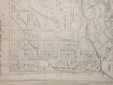
Plan, City of Ballarat (Part) (Ballaarat East), 08/05/1928
Crown Cadastral Plan showing Governement Roads, Crown Parcels, Dimensions, Crown grantees, dated of grants, etc in Ballarat East. The plan shows features such as Bakery Hill, Canadian Station, recreation reserves, timber reserves, Yarrowee Creek, Black Hill Reserve, Eureka Reserve and Garden, Orphan Asylum, Rifle Butts Reserve, Ballarat Woollen Mill, Ballarat Observatory, Sovereign Hill Recreation Reserve, Specimen Vale, Market Reserve, Cemetery WGS 84 Centroid 37 degrees 33' 55" S 143 degrees 52' 38" E E.W. Extent; 5 km N-S Extent; 4 kmmap, plan, ballarat east, ballarat woollen mill, ballarat railway line, ballarat railway station, eureka reserve, eureka cemetery, ballarat orphanage, russell square, bakery hill -
 Federation University Historical Collection
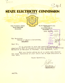
Correspondence, State Electricity Commission of Victoria to Ballarat School of Mines, 1937, 1937
The Ballarat School of Mines trained electricians.Correspondence on State Electricity Commission of Victoria letterhead between the State Electricity Commission of Victoria to Ballarat School of Mines in 1937. .1) Dated 16/01/1937 this item relates to the licensing of Electrical Mechanics Regulations 1935 and is signed by W.J. Price .2) Dated 24/08/1937 this item relates to the practical portion of examination 37/2 in connection with Licensing of Electrical Mechanics at Ballarat on 23 September 1937 and is signed by W.J. Price .3) Dates 18 October 1937 this three page foolscap letter relates to radio interference suppressors, and the increasing us of earth leakage circuit breakers for the protection of installations, and is signed by D. Dunhamstate electricity commission of victoria, ballarat school of mines, electricity, trades, electricians, w.j. price, d. dunham, sec -
 Bendigo Historical Society Inc.
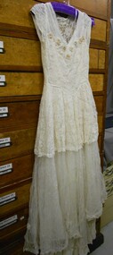
Clothing - WEDDING DRESS
Full length ivory coloured wedding dress. Fitted bodice of lace lined with satin. Small cap sleeves of lace. Vneckline edged with tulle. Nine appliqué flowers with beads and pearl in centre edging the neckline. Piping around waistline with V at centre front. Full length satin skirt with small train at back. Two layers of tulle over skirt at waltz length with dips to floor at centre front and back. Top layer of tulle has lace insert from waist to 37 cms drop back and front.Top layer of tulle below lace has scattered lace flowers appliquéd. Zip (35cms) opening left hand side.costume, female, wedding dress -
 Bendigo Historical Society Inc.
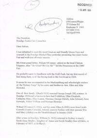
Document - BENDIGO EASTER FAIR COLLECTION: LETTER RE WILLIAM O'CONNOR, 3rd April, 1998
5 page letter to Bendigo Easter Fair Committee from Andrea Phipps, 37 Echuca Road, Rochester, 3 April, 1998, re Andrea's great grandfather, William O'Connor who was attired as the local Chinese Emperor, alias 'the Great Oh Con Ah' who led the procession the the 1880 Fair. A family tree is outlined briefly. Enclosed with letter are 3 pages transcribed from the Bendigo Advertiser, telling the story of the 1880 Easter Fair. William O'Connor came to Sandhurst with the gold rush, first record of him buying land in 1854. A Blacksmith and wheelwright, owned the 'Sydney Forge' with his sister and husband, Ellen and John Brewster.bendigo, bendigo easter fair, william o'connor -
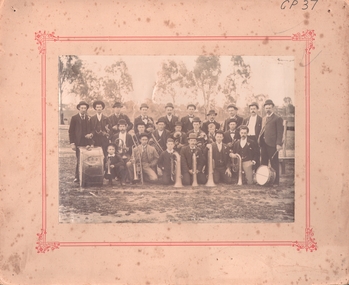 Bendigo Historical Society Inc.
Photograph - EAGLEHAWK BOROUGH BRASS BAND 1896
Sepia photograph of brass band, (mounted on cream board with printed red border). Band on oval (paddock) with scattered trees and fence in background. Twenty adult males, two boys in group. Six kneeling, seven seated and remainder standing with various instruments with drum inscribed BBB 1896. Inscriptions: on front - 'GP37'. Back - J ? Oswald, 53 Peg Leg Road, Eaglehawk. On back, rubber stamp 'Royal Historical Society of Victoria, Bendigo Branch'. History: (HJG Biggs) Borough Brass Band 1896, Eaglehawk. Eaglehawk Borough Brass Band in 1896 with its preponderance of Cornish members (BHS Inc). Previous Acc. No. GP 37.person, group, band -
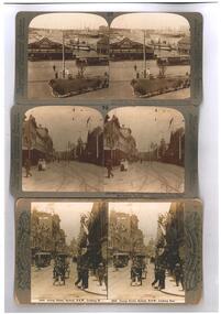 Ballarat Tramway Museum
Photograph - Black & White Photograph/s, Underwood & Underwood and Rose Stereoscopic Views, 1908
Photographic reproduction - sepia coloured of a three stereo pair images with details on the sides. Originals made by Underwood and Underwood of Arlington New Jersey and Westwood New Jersey USA or the Rose Stereoscopic of Melbourne. Printed on A4 size ink-jet printer. Set of three: 1 - Circular quay Sydney with Ferries and a bogie combination car in the view, dated 1980, Image No. (37)-10265. 2 - Auckland Queens St with a complex tram junction in the view. Image No. (72)-10800 3 - George St Sydney looking towards the Queen Victoria building. Image No. 2666 Has trams in the views, centre poles and decorations on the centre poles.trams, tramways, sydney, auckland, stereo photograph -
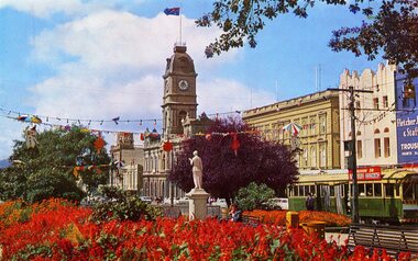 Ballarat Tramway Museum
Postcard, Sturt St floral display
Colour postcard of Sturt St Ballarat looking across a floral display to the Town Hall. Has tram No. 37 travelling westbound along Sturt St. in the right hand side of the view. Also has part of the Fletcher Jones & Staff shop in right hand of the photograph, above the tramcar. Tramcar has an SEC Roof Ad, regarding electric cooking. In blue type under the photograph is the caption "The Gardens and City Hall. Ballarat. Vic." in caps. On the rear of the postcard is "Rose Series Colourview No. 509", published by Rose Stereograph Co. Glen Waverley Vic. Has the outline drawing of a rose in the centre of the postcard. Duplicate of Reg Item - 4279 trams, tramways, sturt st, fletcher jones & staff, gardens, town hall -
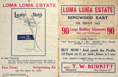 Ringwood and District Historical Society
Flyer, Land Sale Brochure, Loma Loma Estate, Ringwood East, Vic. - circa 1924
Flyer includes extract from "The Sun" 30/10/1924. "Ringwood has been created a Borough with capital value of £680,000. In 1908 there were 173 houses, 8 shops and 720 people. In 1918 the respective figures were 520, 45 and 2,080. For twelve months ended June, 1924, £51,000 worth of Home Sites were sold and £26,000 worth of new buildings were erected. Outward (train) passenger journeys have increased from 94,000 in 1919 to 182,000 in 1923. Train services have been almost doubled and time to Melbourne reduced from 60 to 37 minutes."Bi-fold double-sided land sale advertisement for Loma Loma Estate, Ringwood East, including area map, layout of the estate, and summary of local facilities and services.Subdivision includes Loma Street, Highton Street, Morinda Street, and Station Street (later Railway Avenue) Ringwood East. Agent: T.W. Burkitt, Ringwood, Phone Ringwood 157. -
 Eltham District Historical Society Inc
Photograph - Aerial Photograph, Landata, Eltham / Research, Vic, Jan. 1951
Centred on Brinkkotter Road opposite Yarramie Reserve, Eltham bounded by Maroondah Aqueduct to north, Nyora Road to south, Eltham College to east and Leane Drive to west. Historic Aerial Imagery Source: Landata.vic.gov.au Aerial Photo Details: Project No :65 Project : MELBOURNE AND METROPOLITAN PROJECT NO. 2 Run : 7 Frame : 8 Date : 01/1951 Film Type : B/W Camera : EAG9 Flying Height : 12200 Scale : 12000 Film Number : 1419 GDA2020 : 37°42'32"S, 145°10'41"E MGA2020 : 339408, 5824924 (55) Melways : 22 F3 (ed. 42)Historical aerial photos and photo maps provide viusal evidence of the chronology of changes to the built landscape of the district and assist in dating other imagesaerial photo, 1951-01, eltham, neil webster collection, brinkkotter road, eltham college, leane drive, maroondah aqueduct, melways 22f3, nyora road, yarramie reserve -
 Eltham District Historical Society Inc
Photograph - Aerial Photograph, Landata, Eltham, Vic, Jan. 1951
Centred on Beard Street between Main Road and Frank Street, Eltham bounded by Maroondah Aqueduct to north, Arthur Street to south, Maroong Drive to east and Catholic Ladies College to west. Historic Aerial Imagery Source: Landata.vic.gov.au Aerial Photo Details: Project No :65 Project : MELBOURNE AND METROPOLITAN PROJECT NO. 2 Run : 7 Frame : 9 Date : 01/1951 Film Type : B/W Camera : EAG9 Flying Height : 12200 Scale : 12000 Film Number : 1419 GDA2020 : 37°42'23"S, 145°09'39"E MGA2020 : 337874, 5825170 (55) Melways : 22 B3 (ed. 42)Historical aerial photos and photo maps provide viusal evidence of the chronology of changes to the built landscape of the district and assist in dating other imagesaerial photo, 1951-01, eltham, neil webster collection, arthur street, beard street, catholic ladies college, frank street, main road, maroondah aqueduct, maroong drive, melway 22b3, research (vic.) -
 Eltham District Historical Society Inc
Photograph - Aerial Photograph, Landata, Eltham North, Feb. 1956
Centred on present day 54 Kelway Crescent, Eltham North bounded by Glen Gully Road to north, Meruka Drive to south, Eltham College to east and Leach Street to west. Historic Aerial Imagery Source: Landata.vic.gov.au Aerial Photo Details: Project No :250 Project : MELBOURNE OUTER SUBURBS PROJECT Run : 17 Frame : 113 Date : 02/1956 Film Type : B/W Camera : EAG9 Flying Height : 10000 Scale : 12000 Film Number : 1176 GDA2020 : 37°42'16"S, 145°08'08"E MGA2020 : 335650, 5825336 (55) Melways : 21 G2 (ed. 42)aerial photo, 1956-02, eltham, eltham north, glen gully road, leach street, main road, melway 21g2, meruka drive, montmorency, neil webster collection -
 Eltham District Historical Society Inc
Photograph - Aerial Photograph, Landata, Montmorency, Feb. 1956
Centred on present day Tahlee Place Reserve and Sherbourne Preschool, Montmorency bounded by Progress Road to north, Withers Way to south, Main Road to east and Leach Street to west. Historic Aerial Imagery Source: Landata.vic.gov.au Aerial Photo Details: Project No :250 Project : MELBOURNE OUTER SUBURBS PROJECT Run : 17 Frame : 114 Date : 02/1956 Film Type : B/W Camera : EAG9 Flying Height : 10000 Scale : 12000 Film Number : 1176 GDA2020 : 37°42'50"S, 145°08'02"E MGA2020 : 335512, 5824286 (55) Melways : 21 F5 (ed. 42)aerial photo, 1956-02, neil webster collection, central park, eltham, leach street, main road, melway 21f5, montmorency, progress road, withers way, sherbourne preschool, tahlee place reserve -
 Eltham District Historical Society Inc
Photograph - Aerial Photograph, Landata, Lower Plenty, Feb. 1956
Centred on present day 217 Old Eltham Road, Lower Plenty bounded by Pitt Street to north, Yarra River to south, Main Road to east and Bonds Road to west. Historic Aerial Imagery Source: Landata.vic.gov.au Aerial Photo Details: Project No :250 Project : MELBOURNE OUTER SUBURBS PROJECT Run : 17 Frame : 116 Date : 02/1956 Film Type : B/W Camera : EAG9 Flying Height : 10000 Scale : 12000 Film Number : 1176 GDA2020 : 37°43'58"S, 145°07'49"E MGA2020 : 335237, 5822186 (55) Melways : 21 E10 (ed. 42)aerial photo, 1956-02, neil webster collection, eltham, main road, bonds road, elham, lower plenty, melway 21e10, pitt street, yarra river -
 Eltham District Historical Society Inc
Photograph - Aerial Photograph, Landata, Eltham, Feb. 1956
Centred on present day Shalbury Avenue, Eltham bounded by Leane Drive and Parsons Road to north, Nyora Road to south, Reynolds Road to east and the Diamond Creek to west Historic Aerial Imagery Source: Landata.vic.gov.au Aerial Photo Details: Project No :250 Project : MELBOURNE OUTER SUBURBS PROJECT Run : 18 Frame : 95 Date : 02/1956 Film Type : B/W Camera : EAG9 Flying Height : 10000 Scale : 12000 Film Number : 1176 GDA2020 : 37°41'57"S, 145°09'51"E MGA2020 : 338145, 5825965 (55) Melways : 22 C1 (ed. 42)aerial photo, 1956-02, neil webster collection, eltham, diamond creek (creek), melway 22c1, nyora road, parsons road, reynolds road, shalbury avenue -
 Eltham District Historical Society Inc
Photograph - Aerial Photograph, Landata, Research, Vic, Feb. 1956
Centred on present day Thompson Crescent, Research bounded by Maroondah Aqueduct to north, Thompson Crescent and Nyora Road to south, Bells Hill Road to east and Eucalyptus Road to west Historic Aerial Imagery Source: Landata.vic.gov.au Aerial Photo Details: Project No :250 Project : MELBOURNE OUTER SUBURBS PROJECT Run : 19 Frame : 6 Date : 02/1956 Film Type : B/W Camera : EAG9 Flying Height : 10000 Scale : 12000 Film Number : 1176 GDA2020 : 37°42'38"S, 145°11'02"E MGA2020 : 339927, 5824736 (55) Melways : 22 H4 (ed. 42)aerial photo, 1956-02, neil webster collection, bells hill road, eltham, eucalyptus road, maroondah aqueduct, melway 22h4, nyora road, research (vic.), thompson crescent -
 Eltham District Historical Society Inc
Photograph - Aerial Photograph, Landata, Research, Vic, Apr. 1963
Centred on present day Thompson Crescent and Nicholson Close, Research bounded by Maroondah Aqueduct to north, Nyora Road to south, Eltham College to east and Eltham Gateway Hotel to west. Historic Aerial Imagery Source: Landata.vic.gov.au Aerial Photo Details: Project No :486 Project : MELBOURNE (1963) PROJECT Run : 5 Frame : 61 Date : 04/1963 Film Type : B/W Camera : RC8 Flying Height : 5100 Scale : 9600 Film Number : 1805 GDA2020 : 37°42'24"S, 145°10'06"E MGA2020 : 338528, 5825143 (55) Melways : 22 D3 (ed. 42)aerial photo, neil webster collection, eltham, 1963-04, eltham college, eltham gateway hotel and conference centre, maroondah aqueduct, melway 22d3, nicholson close, nyora road, research (vic.), thompson crescent -
 Eltham District Historical Society Inc
Photograph - Aerial Photograph, Landata, Eltham, Vic, Apr. 1963
Centred on present day John Street, Eltham between Main and Bible streets bounded by Elsa Court to north, Main Road Bridge to south, Wattle Grove to east and Bolton Street to west. Historic Aerial Imagery Source: Landata.vic.gov.au Aerial Photo Details: Project No :486 Project : MELBOURNE (1963) PROJECT Run : 6 Frame : 123 Date : 04/1963 Film Type : B/W Camera : RC8 Flying Height : 5100 Scale : 9600 Film Number : 1805 GDA2020 : 37°43'12"S, 145°08'54"E MGA2020 : 336800, 5823623 (55) Melways : 21 J6 (ed. 42)aerial photo, neil webster collection, 1963-04, bolton steet, elsa court, eltham, john street, main road, main road bridge, melway 21j6, wattle grove -
 Eltham District Historical Society Inc
Photograph - Aerial Photograph, Landata, Eltham, Vic, Apr. 1963
Centred on present day Eltham Ridge, Bolton Street, Eltham bounded by Elsa Court to north, Main Road to south, Bible Street to east and Reichelt Avenue and Rattray Road to west. Historic Aerial Imagery Source: Landata.vic.gov.au Aerial Photo Details: Project No :486 Project : MELBOURNE (1963) PROJECT Run : 6 Frame : 124 Date : 04/1963 Film Type : B/W Camera : RC8 Flying Height : 5100 Scale : 9600 Film Number : 1805 GDA2020 : 37°43'12"S, 145°08'16"E MGA2020 : 335876, 5823604 (55) Melways : 21 G6 (ed. 42)aerial photo, neil webster collection, 1963-04, bible street, bolton street, eltham, eltham ridge, main road, montmorency, rattray road, reichelt avenue -
 Eltham District Historical Society Inc
Photograph - Aerial Photograph, Landata, Eltham, Vic, Apr. 1963
Centred on present day Griffith Park Road, Eltham bounded by Mount Pleasant Road to north, Yarra River and Templestowe to south, Main Road at Reynolds Road to east and Falkiner Street to west. Historic Aerial Imagery Source: Landata.vic.gov.au Aerial Photo Details: Project No :486 Project : MELBOURNE (1963) PROJECT Run : 7 Frame : 233 Date : 04/1963 Film Type : B/W Camera : RC8 Flying Height : 5100 Scale : 9600 Film Number : 1805 GDA2020 : 37°44'04"S, 145°09'10"E MGA2020 : 337237, 5822053 (55) Melways : 22 A10 (ed. 42)aerial photo, neil webster collection, 1963-04, eltham, falkiner street, griffith park road, melway 22a10, mount pleasant road, reynolds road, templestowe, yarra river -
 Eltham District Historical Society Inc
Photograph - Aerial Photograph, Landata, Eltham, Vic, Apr. 1972
Centred on present day Zig Zag Road near Coolabah Drive, Eltham bounded by Allendale Road to north, Park West Road to south, Parsons Road to east and Banks Road to west. Historic Aerial Imagery Source: Landata.vic.gov.au Aerial Photo Details: Project No :985 Project : MELBOURNE 1972 Run : 26 Frame : 191 Date : 04/1972 Film Type : B/W Camera : RC10 Flying Height : 5700 Scale : 9600 Film Number : 2636 GDA2020 : 37°41'56"S, 145°09'26"E MGA2020 : 337533, 5826000 (55) Melways : 22 A1 (ed. 42)aerial photo, neil webster collection, 1972-04, allendale road, eltham, eltham north, zig zag road, banks road, coolabah drive, melway 22a1, park west road, parsons road -
 Eltham District Historical Society Inc
Photograph - Aerial Photograph, Landata, Eltham, Vic, Apr. 1972
Centred on present day Parsons Road, Eltham bounded by Allendale Road to north, Frank Street to south, Research Shops and Raglan Road to east and Zig Zag Road to west. Historic Aerial Imagery Source: Landata.vic.gov.au Aerial Photo Details: Project No :985 Project : MELBOURNE 1972 Run : 26 Frame : 192 Date : 04/1972 Film Type : B/W Camera : RC10 Flying Height : 5700 Scale : 9600 Film Number : 2636 GDA2020 : 37°42'00"S, 145°09'59"E MGA2020 : 338360, 5825897 (55) Melways : 22 D1 (ed. 42)aerial photo, neil webster collection, 1972-04, allendale road, eltham, zig zag road, frank street, melway 22d1, parsons road, raglan road, research (vic.), research shops, eltham barrel -
 Eltham District Historical Society Inc
Photograph - Aerial Photograph, Landata, Eltham, Vic, Apr. 1972
Centred on present day Woodridge Estate, Eltham bounded by Park Road to north, Mount Pleasant Road to south, Stokes Orchard Estate to east and Eltham Railway Station to west. Historic Aerial Imagery Source: Landata.vic.gov.au Aerial Photo Details: Project No :985 Project : MELBOURNE 1972 Run : 27 Frame : 46 Date : 04/1972 Film Type : B/W Camera : RC10 Flying Height : 5700 Scale : 9600 Film Number : 2636 GDA2020 : 37°42'49"S, 145°09'46"E MGA2020 : 338053, 5824365 (55) Melways : 22 C5 (ed. 42)aerial photo, neil webster collection, 1972-04, eltham, eltham railway station, melway 22c5, mount pleasant road, park road, stokes orchard estate, woodridge estate -
 Eltham District Historical Society Inc
Photograph - Aerial Photograph, Landata, Eltham, Vic, Apr. 1972
Centred on present day Main Road at Pryor Street, Eltham bounded by Park West Road to north, Napoleon Street to south, Woodridge Estate to east and Ryans Road to west. Historic Aerial Imagery Source: Landata.vic.gov.au Aerial Photo Details: Project No :985 Project : MELBOURNE 1972 Run : 27 Frame : 47 Date : 04/1972 Film Type : B/W Camera : RC10 Flying Height : 5700 Scale : 9600 Film Number : 2636 GDA2020 : 37°42'45"S, 145°09'12"E MGA2020 : 337223, 5824470 (55) Melways : 22 A4 (ed. 42)aerial photo, neil webster collection, 1972-04, eltham, eltham railway station, woodridge estate, eltham shops, main road, melway 22a4, napoleon street, park west road, pryor street, ryans road