Showing 1430 items matching "allotment"
-
 Kew Historical Society Inc
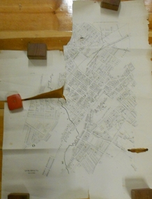
Plan - Willsmere Park Estate, Kew, 1926
Subdivision plans and real estate flyers/brochures reveal a number of aspects of urban development and history. The Kew Historical Society's collection of these plans, as well as advertisements extracted from magazines, cover key aspects of community development and architectural history of Kew and Kew Eat as well as surrounding suburbs. While most of the plans in the collection were gifted to the Society by the former City of Kew, a number of other plans and advertisements have been donated by individuals, of which this is an example.Original 4-page, bifold subdivision plan of the Willsmere Park Estate, Kew. The 1926 land sale advertised '40 superb villa allotments' on the 'Yarra Heights'. Streets within the subdivision included: Willow Grove, Kilby Road, Elm Grove and Belford Road. The double page spread on pages 2 and 3 shows the detailed plan of the 40 lots, surrounded by public parkland [Willsmere Park] and the Kew Golf Links. By the time that this version of the plan was released, only the lots on Willow Grove and Kilby Road remained. willsmere park estate -- kew (vic.), subdivisions - kew (vic.), subdivisions -- kew east (vic.), willsmere park -- kew east (vic.) -
 Kew Historical Society Inc
Plan - Subdivision Plan, Golf View Estate, c.1922
Pru Sanderson, in her groundbreaking ‘City of Kew Urban Conservation Study : Volume 2 - Development History’ (1988), summarised the periods of urban development and subdivisions of land in Kew. The periods that she identified included 1845-1880, 1880-1893, 1893-1921, 1921-1933, 1933-1943, and Post-War Development. These periods were selected as they represented periods of rapid growth or decline in urban development. An obvious starting point for Sanderson’s groupings involved population growth and the associated economic cycles. These cycles also highlighted urban expansion onto land that was predominantly rural, although in other cases it represented the decline and breakup of large estates. A number of the plans in the Kew Historical Society’s collection can also be found in other collections, such as those of the State Library of Victoria and the Boroondara Library Service. A number are however unique to the collection.The Kew Historical Society collection includes almost 100 subdivision plans pertaining to suburbs of the City of Melbourne. Most of these are of Kew, Kew East or Studley Park, although a smaller number are plans of Camberwell, Deepdene, Balwyn and Hawthorn. It is believed that the majority of the plans were gifted to the Society by persons connected with the real estate firm - J. R. Mathers and McMillan, 136 Cotham Road, Kew. The Plans in the collection are rarely in pristine form, being working plans on which the agent would write notes and record lots sold and the prices of these. The subdivision plans are historically significant examples of the growth of urban Melbourne from the beginning of the 20th Century up until the 1980s. A number of the plans are double-sided and often include a photograph on the reverse. A number of the latter are by noted photographers such as J.E. Barnes.The subdivision advertised as the Golf View Estate in Camberwell included 32 allotments bordering on Glen Iris Road, Smith Street (now Smith Road), St Andries Street and Camberwell Road. In the post-war period in which the subdivision took place, the significance of Camberwell as the ‘Heathiest of Suburbs’ because of the undulating nature of its terrain and its high altitude was promoted. The sales pitch aimed at attracting and selling to ‘Gentlemen’ who could take advantage of the nearby trams, which would take them to the ‘heart of the city’.subdivision plans - camberwell, golf view estate -
 Kew Historical Society Inc
Plan - Subdivision Plan, Corsewall Estate, 1938
The Kew Historical Society collection includes almost 100 subdivision plans pertaining to suburbs of the City of Melbourne. Most of these are of Kew, Kew East or Studley Park, although a smaller number are plans of Camberwell, Deepdene, Balwyn and Hawthorn. It is believed that the majority of the plans were gifted to the Society by persons connected with the real estate firm - J. R. Mathers and McMillan, 136 Cotham Road, Kew. The Plans in the collection are rarely in pristine form, being working plans on which the agent would write notes and record lots sold and the prices of these. The subdivision plans are historically significant examples of the growth of urban Melbourne from the beginning of the 20th Century up until the 1980s. A number of the plans are double-sided and often include a photograph on the reverse. A number of the latter are by noted photographers such as J.E. Barnes.The Corsewall Estate was a subdivision, bordering on Barkers Road and Auburn Road, which created Corsewall Close. This relatively late subdivision included 29 allotments. The subdivision plan includes the dimensions of each lot as well as the width of the existing and projected roads and turning circles. The Corsewall Close Precinct is now listed on the Victorian Heritage Database (HO147) and is noted for its ‘consistent flat-type development over the entire street, which has been cleverly designed to make multi-unit dwellings appear as single buildings’.subdivision plans - hawthorn, corsewall estate -- hawthorn (vic.) -
 Bendigo Historical Society Inc.
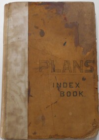
Document - LANDS OFFICE, - INDEX TO CROWN LANDS SURVEYED AND SOLD IN THE DISTRICT OF SANDHURST
Document: Buff hard cover book, with fawn coloured binding on spine (later addition to mend spine?) On front cover drawn in black pen ' PLANS' and 'Index Book' On spine written in black ink ' plans index book'. Contains index of parishes in front of journal with 470 pages indexed to parishes. Double page entries: LH side page: town, suburban or country lands, total lands surveyed. Date of survey. RH page: allotment, section, particulars, no. page. Entries are not dated.Lands Officeland sales, lands office, land surveyed , land sold, bendigo, sandhurst -
 Bacchus Marsh & District Historical Society
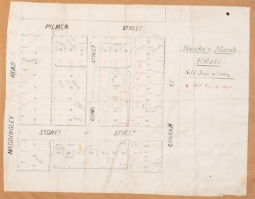
Map, Bacchus Marsh Estate sold 30th June 1888 and sold 28 December 1895
Blocks of land in this area of Bacchus Marsh were sold in lots between 1888 and the late 1890s. This map shows sales made in 1888 and 1895.Single page map showing allotments of land bounded by Pilmer Street, Graham Street, Sydney Street and Maddingley Road (Grant Street) in Bacchus Marsh.The area is dissected by Como Street down the central area. 43 blocks of land are shown with the names of buyers or sellers in 1888 written in black in. Buyers or sellers for December 1895 are written in red ink. Part of a set of maps which are pasted into a bound volume containing 76 maps or plans in total. High resolution digital image stored on BMDHS computer network. bacchus marsh victoria maps, land sales bacchus marsh, pilmer street bacchus marsh, graham street bacchus marsh, sydney street bacchus marsh, como street bacchus marsh, maddingley road bacchus marsh, grant street bacchus marsh -
 Bendigo Historical Society Inc.
Administrative record - FOREST COMMISSION BEE RANGES
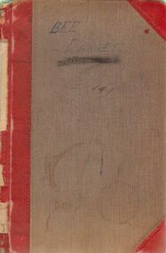
Grey cover leather bound alphabet tabbed Forest Commission record book handwritten title 'Bee Ranges' 141. Numerous entries under various names date from around 1/8/06 indicating commencement of bee-site issue in Victoria. Last dated entry around 1963. Bee-ranges issued include name and address of apiarist along with allotment, parish, district and area size. Districts include Bendigo, Lyal, Walmer, Inglewood, Murrabit, Tarnagulla, Rheola, Bullarto.bendigo, history, bee-keeping, apiary -
 Bendigo Historical Society Inc.
Document - LANDS OFFICE: REPORTS OF LAND SALES BY AUCTION 1876 - 1891, 1876 - 1891
Document: green hard cover journal, buff spine and corners. Contains details of land sales by public auction Kerang, Swan Hill and Boort. m LH page ' Lot, County, Town or parish, section, allotment, sold, unsold, why not sold, upset price, sold per acre. RH page: value of improvements, name of purchaser, residence, deposit forfeited, total amount. On spine in gold lettering ' report of sales by auction' underneath 'land sales' in black. No. 6 on top of spine, letter K on base.Lands Officeland sales, kerang, swan hill, boort, sandhurst, lands office -
 Bendigo Historical Society Inc.
Document - MARKS COLLECTION: PLAN OF SANDHURST CITY CENTRE AND SURROUNDING AREA ( NO. 1 )
Plan on heavy parchment - section neatly cut out of area now Kennington. Written on plan in black print ' Sheet No. 1. Sandhurst'. Plan shows Government Camp, Commissioner's Gully, old cemetery site, manure depot, cattle market, Benevolent Asylum Reserve, railway reserve. Landowners' names on allotments. On bottom lithographed at the Department of Lands and Survey, Melbourne, by D. Henerson, March 12th., 1867 Plan part of George Lansell, Fortuna auction, documents found in wardrobe purchased by Marks family in 1930's.bendigo, planning, sandhurst 1867 -
 Bendigo Historical Society Inc.
Document - MARKS COLLECTION: PARISH PLAN OF WHITE HILLS
Sepia coloured map showing allotments in Parish of Sandhurst (White Hills) Written on LH side of map town and Suburban Lots White Hills Parish of Sandhurst. Scale is shown in chains. Surveyed by Horage Walker. Photo lithographed at the Department of Lands & Survey, Melbourne by J.Noone, Price 1/-. 6th. January 1865. Map shows Race Course Reserve at top of sheet, Municipal boundary is marked on LH side. Comments re vegetation throughout map. For example, poor soil timbered with Box scrub.on the back--Plan of Land White Hills Sandhurstbendigo, planning, white hills parish map, horage walker, j noone, department of lands and survey, -
 Mt Dandenong & District Historical Society Inc.
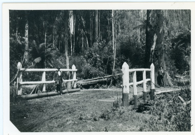
Photograph, Barber's Bridge on Olinda Creek
John Lundy-Clarke grew up in the Kalorama/Mt Dandenong area and later in life (1972-74) began to write a comprehensive history of the area working from an original settlement map in an effort to cover all areas. Barbers Bridge was named after George Barber, an early settler.Black and white photograph showing a man standing on a bridge over the Olinda Creek. 1910Handwritten n reverse: Barbers Bridge on Olinda Creek 1910. This was a ford crossed by the road after Isaac Jeeves selected allotment “C” “Jeeves Saddle” in 1871 and stopped travel through his property. The bridge has been built several times but at time of writing (1974) is replaced by a culvert consisting of two pipes two feet six inches wide. They are quite incapable of carrying the maximum flow of the creek and will be swept away.lundy-clarke, barber, barbers bridge, isaac jeeves, jeeves saddle, bridge, olinda creek -
 Ringwood and District Historical Society
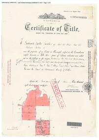
Document, Certificate of Title - Crown Allotments 4A, 4B, 11A, 11B, and Crown Sections 5 and 6 (later including Wonga Park, Vic.), Parish of Warrandyte, County of Evelyn - 17 June, 1895
A4 copies of Landata Victoria Historical Search documents - Vol 2574 Fol 514725.Frederick Walter Purches of Ascot Vale, Wholesale Butcher, is now the proprietor of an Estate in Fee-simple - 2,291 acres 3 roods 24 perches or thereabouts, being Crown Allotments 4A, 4B, 11A, 11B, and Crown Sections 5 and 6, Parish of Warrandyte, County of Evelyn. Transfers include The Mutual Assurance Society of Victoria Limited, 15th August, 1896, The President Councellors and Ratepayers of the Shire of Lilydale, 13th March, 1899. -
 Eltham District Historical Society Inc
Document - Newspaper clipping, "The lap of luxury; Blending into Eltham environ", Property Age, The Age, Wednesday 24 June 1998, p5, June 1998
Both of the architects involved in the 2.4-hectare Kinloch Gardens parkland development in Arthur Street, Eltham, are now living on the estate. The project was conceived by Eltham architect Ian Jelbart, whose family has owned the land for more than 100 years, and fellow architect Graeme Gunn, who in the 1960s was one of the creators of the Merchants Builders concept that set new trends in Melbourne housing. The $5 million project is based around two of the original buildings, on what was once a 100-hectare farm owned by the Jelbart family. Ian Jelbart always intended to continue living in the original homestead building, and now Graeme Gunn has moved into the big residence that once was the barn. Kinloch Gardens is designed to combine the more manageable land sizes increasingly demanded by buyers with ample "internal space, flexible floorplans, privacy and individuality of designs. Individual houses are placed on small separate allotments around an area of private parkland. The aim is to ensure total privacy, offer virtually unlimited views and parkland vistas, and remain aesthetically compatible with the local environment. Homes in four basic designs over either two or three levels are being sold off the plan, with prices ranging from the high $200,000s to the high $300,000s. Two have already been sold. Indication of land-only values The prices being asked for some vacant blocks offered for private sale provides an enlightening comparison of the relative "land only" values for homes sites in various areas. A 751 sq metre block on a new residential estate in Bentleigh/Carnegie is offered at $235,000, equivalent to $312/square metre; while in Merrett Drive, Williamstown, a 561 sq metre allotment offered for $169,000 carries a rate of $301/sq metre. In Barnsbury Road, Balwyn, the $450,000 price tag on a 584 sq metre allotment equates to $770 sq metre; and in York Street, Richmond, a 198 sq metre postage stamp is priced at $230,000 or $1162/sq metre. - Rex BookerDigital file only; created from scan undertaken by EDHS of item on loanarthur street, eltham, graeme gunn, houses, ian jelbart, jelbart property, kinloch gardens, rob maclellan, robert marshall, woodridge estate -
 Bendigo Historical Society Inc.
Document - MCCOLL, RANKIN AND STANISTREET COLLECTION:CENTRAL DEBORAH GOLD MINE, 28/1/1948
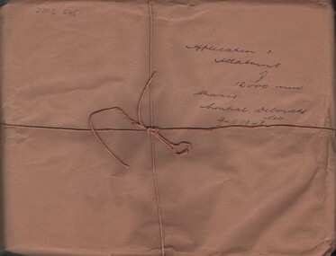
'Applications and allotment of 12,000 new shares, containing lists of shareholders for The Central Deborah Gold Mine as at 15th January 1948, contains information regarding applications for shares, transaction details of what was sold, cost and allocated to list of people who they were sold to'. A3 lined paper, hand written with names of each purchaser and balances of each transactions. Blue & white forms printed as contracts of applications to the directors of the company to state who the owners of the shares were and receipt of payments. Forms state the issue of release of 12,000 contributing shares of 1 pound each per share which were submitted by shareholders desiring to exercise their quota rights. Also contains hand written receipts from the Bank of New South Wales Chambers regarding applications to purchase shares from W.J Donovan who was a member of the Melbourne stock exchange which was part of Union Bank of Australia in 1948. All paperwork signed and stamped by McColl,Rankin & Stanistreet Legal Managers & Accountants upon receipt. All wrapped in brown paper with hand written on front 'Application + Allotment of 12,000 shares Thanks Central Deborah Co. Feb 1948'.McColl,Rankin & Stanistreet Legal managers & Accountants.document, gold, central deborah gold mine, central deborah gold mine, gold mine, mccoll rankin & stanistreet, bendigo, business records. -
 Mt Dandenong & District Historical Society Inc.
Photograph
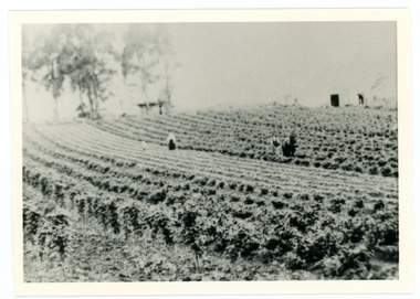
William Dower came with his family to the Mt Dandenong in 1898, taking up a 10 acre allotment. William and hs wife Elizabeth had seven boys (Will, Harry, Bert, Walter, Joe, Edgar, Robert) and four girls (Emmy, May, Ada, Ruby). The property secured by William Dower was known as ‘Cambridge Gardens’ and had a two room slab hut. William and his sons added another five rooms using trees from the property. The family established extensive crops and worked hard for their success. The acreage extended to 30 when the family bought up neighbouring properties.Black and white photograph showing rows of berry crops. Reverse of photograph has handwritten description by John Lundy-Clarke.LOT 10 section 2 of the Village Settlement owned as registered by Dobson, then Bert Dower, then Edgar Dower. Property was named "Bonnie View" and photo was taken from near where the Channel O tower stands looking south east towards corner of Ridge Road and Selwyn Lane taken 1920.bert dower, edgar dower, bonnie view, channel o, dobson, selwyn lane -
 The Beechworth Burke Museum Research Collection
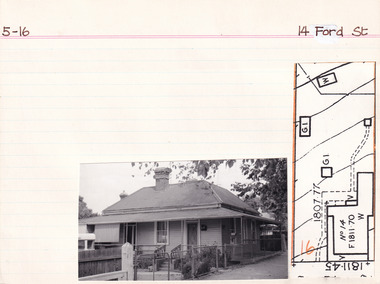
Card (Series) - Index Card, George Tibbits, 14 Ford Street, Beechworth, 1976
George Tibbits, University of Melbourne. Faculty of Architecture, Building and Town & Regional PlanningIndex system that support the research for Beechworth : historical reconstruction / [by] George Tibbits ... [et al]Arranged by street names of BeechworthEach index card includes: street name and number of property, image of property, allotment and section number, property owners and dates of ownership, description of the property according to rate records, property floor plan with dimensions.beechworth, george tibbitsbeechworth, george tibbits -
 Eltham District Historical Society Inc
Negative - Photograph, The Bridge, Hurstbridge, Vic, c.1925
Copied from brochure "Wattle Valley Estate" 7 minutes from the bridge. The new bridge designed by Sir John Monash over the Diamond Creek near Hurst's home of 'Mia Mia' at Hurstbridge. The Wattle Valley Estate was first advertised in August 1925 as weekend building allotments by the Greater Melbourne Land and Development Company. Advertised from £28.10.0 or £60 per block. In August 1926, 30 picked allotments of 60x150 feet were put up for auction Saturday August 14, 1926 with frontages to Valley View Road and Fawkner Crescent advertised in the “Heart of the Glorious Wattle Country” and “Within 15 Minutes of the Newly Electrified Railway Station”. The Advertiser on August 13, 1926 in an article promoting the auction stated “the estate is regarded as one of the best in the district, and will be sold practically without reserve.” It is noted that an advertisement running in The Argus February 22, 1951 offered the remaining 16 blocks for sale at £12.10.0 or £200 the lot. By March 7, the remaining blocks were advertised at £17.10.0 The Wattle Valley Estate took over 20 years to sell and then people could not build on them This image was also used in a brochure advertising the "Wattle Valley Estate", which forms part of the Shire of Eltham Pioneers Photograph Collection (Cross Reference Photo No.(s): 1056, 1057)This photo forms part of a collection of photographs gathered by the Shire of Eltham for their centenary project book,"Pioneers and Painters: 100 years of the Shire of Eltham" by Alan Marshall (1971). The collection of over 500 images is held in partnership between Eltham District Historical Society and Yarra Plenty Regional Library (Eltham Library) and is now formally known as the 'The Shire of Eltham Pioneers Photograph Collection.' It is significant in being the first community sourced collection representing the places and people of the Shire's first one hundred years.Digital image 4 x 5 inch B&W Negshire of eltham pioneers photograph collection, hurstbridge, bridge, diamond creek (creek), monash bridge, wattle valley estate -
 Ringwood and District Historical Society
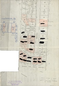
Document, Map showing numbered subdivision allotments with hand-written notations and redactions - 1924
Foolscap size page Map by Arnold Wilson & Associates, Engineers & Surveyors, 399 St.Kilda Road, Melbourne, Tel 26-1840 - 1924/4. Subdivision includes Ilford Road, Karen Court, Washusen Road and Dirkala Avenue, Heathmont. Also includes hand-drawn allotments on Canterbury Road and Balfour Avenue. Page rubber-stamped by building company A & C Jaworski, Office 2, 23 Ringwood Street, Ringwood 3134, Tel 870-0820, A.H. 870-2062. -
 The Beechworth Burke Museum Research Collection
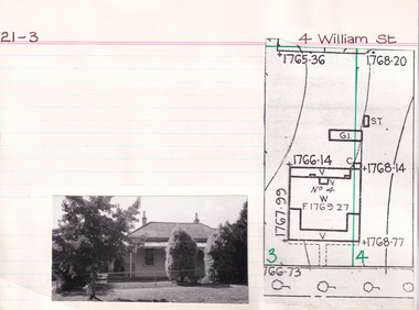
Card (Series) - Index Card, George Tibbits, 4 William Street, Beechworth, 1976
George Tibbits, University of Melbourne. Faculty of Architecture, Building and Town & Regional PlanningIndex system that support the research for Beechworth : historical reconstruction / [by] George Tibbits ... [et al]Arranged by street names of BeechworthEach index card includes: street name and number of property, image of property, allotment and section number, property owners and dates of ownership, description of the property according to rate records, property floor plan with dimensions.beechworth, george tibbitsbeechworth, george tibbits -
 The Beechworth Burke Museum Research Collection
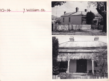
Card - Index Card, George Tibbits, 7 William St, Beechworth, 1976
Property - 7 William Street Beechworth, Section 10, Town Allotment 14, 100 x 250 Ownership details and history - 11 Apr 1856 - W.C. Hill 1857 F.J. Doull 1862 F.J. Doull, Land 33' x 165', Prem 21' x 13' x'9" / Prem 20' x 13'9" (occupier R. Nelson) 1866 - Land 33 x 165 Prem 20' x 13'9" slabs & bark, £7.10.0 1870 - T Dalziel - Land Only 66x165 1883 - Land Only Architectural Index Card - Brian Pump and Tony Dugan - Photographers beechworth, george tibbits -
Warrnambool and District Historical Society Inc.
Document, signatures and a sketch map
This document comes from the Ardlie collection. It is presumed that it is part of the material that belonged to William Ardlie, a prominent lawyer in Warrnambool in the 19th and 20th centuries. It is not clear if the document is a copy or an original. It is an 1886 document in which the purchasers of Allotments 127,128 and 129 in Coulstock Street, Warrnambool requested a change to the original land situation. They wished to eliminate a laneway shown on the original purchase document owned by Adam Bell and transfer the lane land to the new purchasers. The signatures on the document include Isabella Helpman, R.D. Burall, Adam Bell, Anthony Derrick and another signature not able to be deciphered. The sheet includes a sketch showing the proposed change to the land division. This item is of minor interest as a document from the 19th century dealing with a land transfer proposal by some prominent Warrnambool residents at the timeThis is a sheet of paper with handwriting, signatures and a sketch map, all in black ink. The page is a little yellowed with age. adam bell, warrnambool, wiliam ardlie -
 Bendigo Historical Society Inc.
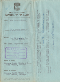
Document - H.A. & S.R. WILKINSON COLLECTION: CONTRACT OF SALE
Contract of sale dated 26th September, 1957 between Mr. W.B. Nicholls (seller) and Mr. G. Stekelenburg (buyer). Solicitor for vendor: Messrs. Hyett, Willis & Hyett, Bull Street, Bendigo. Solicitor for purchaser: Messrs. Hyett, Willis & Hyett, Bull Street, Bendigo. For lot 34, Alamein Court, Golden Square being lot 34 on plan of subdivision lodged in the office of titles No. A389550 being part of Crown allotment 7 section 31A, being land described in Crown grant volume 8113 folio 731. Price 3,850 pounds.organization, business, h.a. & s.r wilkinson real estate -
 Bendigo Historical Society Inc.
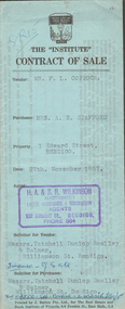
Document - H.A. & S.R. WILKINSON COLLECTION: CONTRACT OF SALE
Contract of sale dated 27th November, 1957 between Mr. F.L. Coppock (seller) and Mrs. A.E. Stafford (buyer). Solicitor for vendor: Messrs. Tatchell, Dunlop, Smalley & Balmer, Williamson Street, Bendigo. Solicitor for purchaser: Messrs. Tatchell, Dunlop, Smalley & Balmer, Williamson Street, Bendigo. For property No.1 Edward Street, Bendigo being part of Crown allotment 12 section 125C described in certificate of title volume 6967 folio 283, together with blinds and electric light fittings and shades and all linos. Price 950 pounds.organization, business, h.a. & s.r wilkinson real estate -
 Bendigo Historical Society Inc.
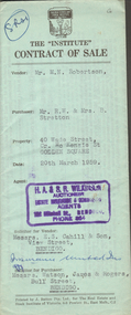
Document - H.A. & S.R. WILKINSON COLLECTION: CONTRACT OF SALE
Contract of sale dated 20th March, 1959 between Mr. M.N. Robertson (seller) and Mr. R.W. & Mrs. B. Stretton (buyer). Solicitor for vendor: Messrs. E.S. Cahill & Son, View Street, Bendigo. Solicitor for purchaser: Messrs. Watson, James & Rogers, Bull Street, Bendigo. For property No. 40 Wade Street, corner McKenzie Street, Golden Square, land being part of Crown allotment 0 section 44B described in certificate of title volume 7100 folio 878, together with blinds and linos as inspected. Price 1,550 pounds.organization, business, h.a. & s.r wilkinson real estate -
 Bendigo Historical Society Inc.
Document - H.A. & S.R. WILKINSON COLLECTION: CONTRACT OF SALE
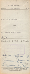
contract of sale of land dated 12th January, 1954 between Mr. C.H. Boyle (seller) and Mr. Keith Harold Roy (buyer) for land being parts of Crown allotment 144 section K at Iron Bark Gully described in certificate of title volume 7007 folio 363 and situate 25 Bannerman Street, Bendigo. Together with 5-roomed weatherboard dwelling and all sundry, also all window blinds, curtains and linos on kitchen and back bedroom floors and all electric light fittings and shades. Price 1,600 pounds.organization, business, h.a. & s.r wilkinson real estate -
 Bendigo Historical Society Inc.
Document - H.A. & S.R. WILKINSON COLLECTION: CONTRACT OF SALE
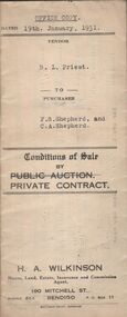
Conditions of sale by private contract dated 19th January, 1931 between R.L. Priest (seller) and F.S. Shepherd & C.A. Shepherd (buyer) for land situate Epsom Road, Eaglehawk Flat, being conditional purchase lease of special settlement area land from the Crow, entered in the register book volume 1001 folio 200107, allotments 152B and 152C section N, containing 15 acres no roods 27 perches at the present occupied by Mr. Hummel as tenant. Together with 5-roomed weatherboard dwelling and all sundry. Price 250 poundsorganization, business, h.a. & s.r wilkinson real estate -
 Bendigo Historical Society Inc.
Document - H.A. & S.R. WILKINSON COLLECTION: CONTRACT OF SALE
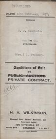
Conditions of sale by private contract dated 10th February, 1937 between D.J. Gaughwin (seller) and Mrs. I. Spooner (buyer) for land situate No. 27 Hamlet Street, Bendigo being Crown allotment 5 section 98C being land described in certificate of title volume 1681 folio 336040, together with 5-roomed weatherboard dwelling and all sundry. Also gas stove, all roller blinds, electric light fittings e globes, wire doors, wire screens and both heaters. Price 625 pounds.organization, business, h.a. & s.r wilkinson real estate -
 Bendigo Historical Society Inc.
Document - H.A. & S.R. WILKINSON COLLECTION: CONTRACT OF SALE
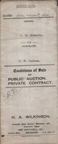
Conditions of sale by private contract dated 26th October, 1937 between J.B. Edwards (seller) and G.F. Sansom (buyer) for land situate ''Hazelbrae'' Corner Russell and Hamlet Streets, Bendigo and occupied by tenant, having a frontage of 82 feet 6 inches to Russell street by a depth of 68 feet 6 inches to Hamlet Street and being part of Crown allotment 22 section 74Cand described in certificate of title volume 3289 folio 657653, together with 5-roomed brick and weatherboard dwelling and all sundry.. Price 465 pounds.organization, business, h.a. & s.r wilkinson real estate -
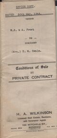 Bendigo Historical Society Inc.
Document - H.A. & S.R. WILKINSON COLLECTION: CONTRACT OF SALE
Conditions of sale by private contract dated 30th May, 1944 between W.S. & A. Frost (sellers) and Mrs. T. M. Swale (buyer) for land situate No. 212 Queen Street, Bendigo being Crown allotment 2 section 139C described in certificate of title volume 4557 folio 911246, together with 5-roomed weatherboard dwelling and all sundry. Price 385 pounds. Also attached 6 receipt 2 issued by George Rasmussen, 2 by Langley & Son, 1 by J.S. Barker plus 1 Unknown for various materials.organization, business, h.a. & s.r wilkinson real estate -
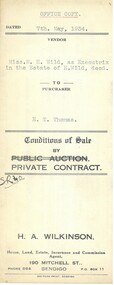 Bendigo Historical Society Inc.
Document - H.A. & S.R. WILKINSON COLLECTION: CONTRACT OF SALE
Conditions of sale by private contract dated 7th May, 1934 between Miss M.H. Wild as executrix in the estate of E. Wild deceased (seller) and E.T. Thomas (buyer) for land situate Hargreaves Street corner Wattle Street, Bendigo being Crown allotment 25 section 97C described in certificate of title volume 1562 folio 332318. Also that piece of land adjoining above being land described in residence area certificate No.30319 in the books of the mining registrar at Bendigo. Together with 6-roomedweatherboard dwelling and all sundry. Price 350 pounds.organization, business, h.a. & s.r wilkinson real estate -
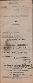 Bendigo Historical Society Inc.
Document - H.A. & S.R. WILKINSON COLLECTION: CONDITION OF SALE
Conditions of sale by private contract dated 22nd July, 1947 between N.E. & Mrs. B. E. Woodall (sellers) and Mrs N.I. Rigby & Mrs D.M. Sayer (buyer) for land situate 86 Violet Street Bendigo, at present occupied by Mr. Bice as tenant, being the land in conveyance registered No. 66, book 589. Also the land untransferred in certificate of title volume 5350 folio 1071748 Crown allotment 19 section 11B, together with 5-roomed brick and weatherboard dwelling and all sundry. Price 600 pounds.organization, business, h.a. & s.r wilkinson real estate