Showing 1104 items matching "information map"
-
 Melbourne Tram Museum
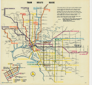
Map, Melbourne & Metropolitan Tramways Board (MMTB), "Tram Route Guide", Jun. 1979
Full colour map or poster printed on clear plastic with an adhesive peel off backing sheets, titled "Tram Route Guide". Map dated 6/79, showing proposed extension to Bundoora, routes with route numbers and names of main destinations. Has notes about the services, weekend and telephone numbers for information. 1979 Two copies held. See Reg Item 3765 for a larger version of this map.trams, tramways, mmtb, map, routes, posters -
 Melbourne Tram Museum
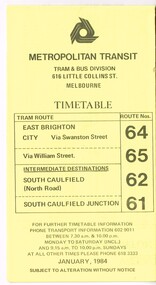
Ephemera - Timetable, Metropolitan Transit Authority (MTA), "Metropolitan Transit Timetables", Jan. 1984
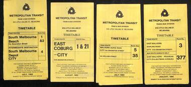
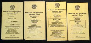
Set of 13 Metropolitan Transit Tram timetables, folded sheets, 8 to 10 sections, providing timetables for specific routes, day of week giving information on tram times at specific time points, route map, sections and fares and Transport Information Centre telephone number. All printed on yellow paper. .1 - Route 64 (65 via William St), 62 and 61 - dated January 1984. .2 - Route 3 (Darling Road via Swanston St) with route 377 bus on Sundays via Batman Ave. - July 1984 .3 - Route 5 - Malvern Burke Road - City - July 1984. Cover was printed showing route 35 via William St, but has been crossed out in pencil. .4 - Route 6 (Glen Iris - City) and Route 7 (Malvern Town Hall) - July 1984. Cover was printed showing route 36 via William St, but has been crossed out in pencil. .5 - Route 8 - Toorak - City - June 1984. Cover was printed showing route 38 via William St, but has been crossed out in pencil. .6 - Route 10 and 11 West Preston via Collins St and Route 13 via Latrobe St - March 1985. .7 - Route 10 and 12 - South Melbourne and St Kilda Beach - City (Brunswick St) via Collins St and route 17 - Park and Clarendon Sts. - Sept 1984 .8 - Route 15 and 22 - Moreland to City, July 1983 .9 - Route 15, 16 and 55 - St Kilda Beach to City via Swanston St - July 1983. Cover was printed showing route 53 via William St, but has been crossed out in pencil. .10 - Route 19 (Coburg), 18 (Brunswick) and 20 (Bell St) - City - August 1984 .11 - Routes 59 (Airport West), 49 (Niddrie), 52 (Bulla Road), 51 (Essendon Station) and 81 (Essendon Depot) - April 1985. .12 - Route 69 - Kew Cotham Road to St Kilda Beach - Sept. 1984 .13 - Route 72 (Camberwell - City), 32 via William St and route 73 (Camberwell Junction) - August 1984. .14 - Route 1 and 21 - East Coburg - City - August 1983. Full Image of .10 added 9/4/17 following a query about route 19 timetables - see image i6trams, tramways, the met, timetables, melbourne, latrobe st, la trobe st, mta, buses, route 64, route 65, route 3, route 5, route 6, route 8, route 10, route 11, route 12, route 13, route 17, route 15, route 22, route 16, route 55, route 19, route 18, route 20, route 59, route 49, route 52, route 51, route 81, route 69, route 72, route 32, route 73, route 1, route 21 -
 Melbourne Tram Museum
Pamphlet, VicRoads, "Have your say on improving tram 109", Sep. 2005
Pamphlet or book - 12 pages, A4 landscape printed on gloss white paper, centre stapled, titled "Have your say on improving tram 109", consultative or consultation document for the Box Hill tram route. Gives information and consultative meetings - looks at the relocation and reconstruction of tram stops, centre platform stops, kerb access stops, maps and alternative stop locations from Kew Junction to Union Road - stops within the City of Boroondara. Contains a form that could be posted back to VicRoads. Published 9/2005c, has dates for October 2005 meetings. Has the logos of Victorian Government, VicRoads, Yarra Trams and the City of Boroondara. Two copies held .1 - five fold pamphlet - DL - titled "Box Hill Tram line extension", promoting the construction of the route 109 to Box Hill. Message from the Minister, Peter Batchelor, who is Yarra Trams, project details, benefits and why.trams, tramways, yarra trams, route 109, box hill, mont albert, kew junction, superstops, tram stops, city of boroondara, vicroads, new tramway, construction -
 Melbourne Tram Museum
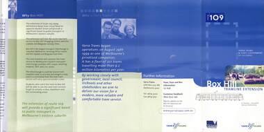
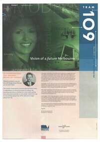
Newsletter, Yarra Trams, "Tram 109", 2001 - 2003
Set of three A4 printed newsletters, stapled in top left hand corner, titled "Tram 109" and two associated pamphlets. .1 - 4 pages - issue 1 - September 2001 - with introduction by Minister for Transport Peter Batchelor introducing the new route 109, Hubert Guyot (CEO Yarra Trams) about the Superstops, details of the new low floor trams and details of the extension to Box Hill along with time line. .2 - 4 pages - issue 2 - Autumn 2002 - message from CEO, diagrammatic map and attributes, and a general update on progress, including a timeline. .3 - single folded A3 sheet printed both sides - Issue 4 - Summer 2003 - noting the wheel chair access to tram, opening on 2/5/2003, message from CEO and launch details, including notes on patronage increase. .4 - Pamphlet - DL four fold - printed on gloss paper full colour dated Autumn 2002 with message from Minister for Transport Peter Batchelor, diagrammatic map of extension showing tram stop facilities and locations of important places, low floor trams and contact details for further information. .5 - Pamphlet - DL five fold - printed on gloss paper full colour dated c mid 2001 with message from Minister for Transport Peter Batchelor, details of Yarra Trams, why the extension and project map. Has Harry the Yarra Trams Infrastructure Mascot. .6 - Pamphlet - 4 fold A4 landscape - printed both sides, issue 3, noting the need for universal access, St Vincent's plaza upgrade and tram stop options.trams, tramways, yarra trams, route 109, box hill, mont albert, superstops, tram stops, opening, st vincent's plaza -
 Melbourne Tram Museum
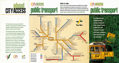
Pamphlet, The Met, "City Access Public Transport", mid 1980's
Pamphlet - four fold DL - gloss paper - titled "City Access Public Transport", providing maps and details of public transport, city circle, ticket information. Includes The Met system map and images of a W class with a destination of Football and Daily Adult Zone 1 tickets. Printed primarily for tourists. Published by The City of Melbourne, , The Met and the City Access group. Rear cover includes a list of those involved in City Access.trams, tramways, city centre, city of melbourne, public transport, tourism, tourist guides -
 Melbourne Tram Museum
Ephemera - Timetable - Met Bus - set of 5, The Met, 1996/97
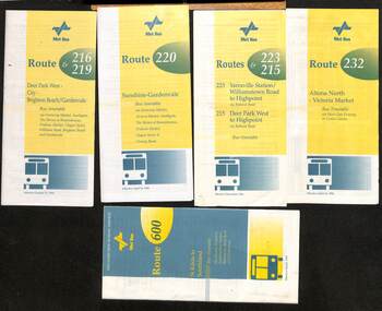
Set of 5 Met Bus timetables - all with a route map on the rear. 1 - Routes 216 and 219, Deer Park West - City - Brighton Beach/Gardenvale - dated 27/10/1996 2 - route 220 - Sunshine - Gardenvale - dated 14/4/1996 3 - Routes 223 and 215 - Yarraville Station to Highpoint and Deer Park West to Highpoint - dated Dec. 1996 4 - Route 232 - Altona North - Victoria Market via West Gate Freeway and Crown Casino - dated 14/4/1996 - this service effectively combined the two railway tram routes. 5 - Route 600 - St Kilda to Southland via Elwood, Brighton, Sandringham, Black Rock and Cheltenham - dated March 1997Yields information about some of the Met Bus services in 1996 and 1997.Set of five Met Bus timetables, DL size, printed in two colours.maps, bus services, route 216, route 219, route 220, route 223, route 215, route 232, route 600, met bus -
 Melbourne Tram Museum
Document, A V McLean et al, "Conversion of Convential railway to light rail", 1982
Report prepared by A V McLean Corporate Planning Manager The Met and P A Don Group Manager V/Line about a 1982 study about the replacing the two heavy rail services to St Kilda and Port Melbourne with Light Rail. The paper looks at the financial, economic, accessibility and patronage implications of the conversion. Has maps, tables and recommendations, including routing via Collins and Bourke Streets. Yields information about the conversion of the St Kilda and Port Melbourne rail lines to light rail which opened to St Kilda in Nov. 1987.Paper or report, photocopied 16 A4 pages stapled in the top left hand corner.tramways, light rail, conversion, st kilda, port melbourne, railways, light rail conversion -
 Melbourne Tram Museum
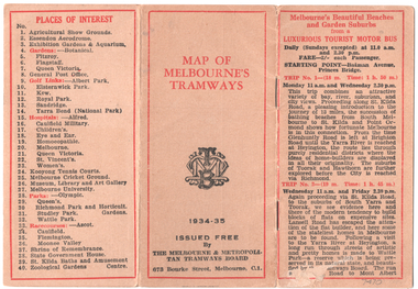
Map, Melbourne & Metropolitan Tramways Board (MMTB), "Map of Melbourne Tramways", 1934
Map booklet consists of three pages of bus and tram round trips, 3 center pages for a map of electric and cable trams, route numbers, and points of interest. Has 4 pages giving an index to routes and first and last trams to and from the City. Shows points where suburban routes are intersected by City routes. One page of places of interest. Dated 1934/35.Demonstrates methods of giving information to visitors to Melbourne and yields information about tram services at the time in Melbourne.Map - 2 octavo cards stapled and folded into 12 pages. All printing is in black with red headings and highlights except for the map which is in four colours.tramways, trams, mmtb, map, timetables, tourist trips -
 Melbourne Tram Museum
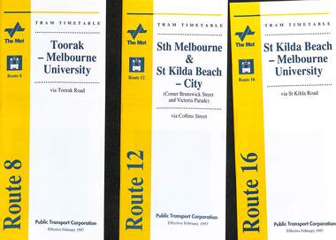
Ephemera - Timetable - The Met - set of 3, The Met, 1997
Set of 3 The Met timetables, with an image of the relevant depot manager, details of hiring a tram, The Met fare system, and a diagrammatic map. All are revised issues of earlier timetables and dated Feb. 1997 unless noted otherwise. 1 - Route 8 - Toorak - Melbourne University 2 - Route 16 - St Kilda Beach - Melbourne University 3 - Route 12 - Sth Melbourne & St Kilda Beach - CityYields information about some of The Met tram services Feb. 1997Set of 3 The Met timetables, DL size, printed in two colours.timetables, the met, route 8, route 16, route 12 -
 Melbourne Tram Museum
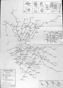
Map, The Met, "Public Transport Map - No. 13", 1984
Map No. 13 undated with the buzzing bee symbol on the front and throughout at the time of the introduction of the neighbourhoods. Includes description of tram and bus routes, private bus routes. Has contact details for bookings and lost property etc and how to use the map. Gives extensive details of the neighbourhood tickets and their used. C1984.Yields information about Melbourne public transport services in 1984.Fold out map (36 sections 9 across x 4 deep), "Public Transport Map", coloured of Melbourne's Tram and Bus routes, route numbers, rail lines, detailed for the central part of Melbourne and the outer Metropolitan services.tramways, melbourne, tram services, bus services, maps -
 Melbourne Tram Museum
Map, Public Transport Corporation (PTC), "Public Transport Map of Melbourne", 5/1995
Map Includes description of tram and bus routes, private bus routes, and rail lines. Has contact details for bookings and lost property etc and how to use the map. Gives details of the ticketing system, along with photographs of the various modes. Dated May 1995 with a stylised image of some of Melbourne's landmarks on the cover. Published by the Public Transport Corporation.Yields information about Melbourne public transport services in 1995.Fold out map (36 sections 9 across x 4 deep), "Public Transport Map", coloured of Melbourne's Tram and Bus routes, route numbers, rail lines, detailed for the central part of Melbourne and the outer Metropolitan services.tramways, melbourne, tram services, bus services, maps, railways -
 Melbourne Tram Museum
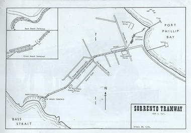
Document - report, Norm Wadeson, "Sorrento Tramway", 1961
... 7717 for maps and photographs. Yields information about ...Notes prepared by Norm Wadeson 1961 from Lands Department Records about the history of the Sorrento Tramway. Has notes on the formation, operation, passengers carried, land, possible extension, deputations to the Minister, Mr George Copin, and closure. See item 7717 for maps and photographs.Yields information about the Sorrento tramway co. and its Lands Department records.Two quarto sheets, typed - stapled in top left hand corner.tramways, tramcars, sorrento, george coppin -
 Melbourne Tram Museum
Document - La Trobe St, Public Transport Victoria (PTV), "Tram stop upgrades, relocations and removals", July 2024
Digital document from Public Transport Victoria (PTV) about the installation of platform stops in La Trobe St including the removal of existing stops. Has a map and images of the works that were undertaken during July and August 2024.Demonstrates a PTV information document regarding the installation of Platform stops in La Trobe St.Digital document - 5 pagestramways, platform stops, consultation, la trobe st, tram tracks -
 Melbourne Tram Museum
Letter (Collection), Melbourne & Metropolitan Tramways Board (MMTB), Extension of Burke Road line from Malvern Road, 1926 to 1938
Melbourne and Metropolitan Tramways BoardRecord of correspondenceLetters in date orderDetails correspondence both internal and external with Councils and others about the possibility of extending the Burke Road line from the corner of Malvern Road along Waverley Road to Dandenong Rd, some 1.5miles. Has a small hand drawn map showing the various possibilities.tramways, new track, burke road, extensions, malvern, correspondencetramways, new track, burke road, extensions, malvern, correspondence -
 Melbourne Tram Museum
Ephemera - Timetable/s, Melbourne & Metropolitan Tramways Board (MMTB), "MMTB bus Timetables", 1970
Set of two bus timetables for specific routes, day of week giving information on tram times at specific time points, route map, sections and fares and organisation address - 616 Little Collins St. Melbourne. 1 - East Kew - Box Hill - Doncaster - May 1970 - no route numbers given. 2 - Fishermen's Bend - City via three different routes - August 1970 Yields information about two MMTB 1970 bus routes.Set of 2 MMTB Tram timetables, folded sheets, 10 sections on white paper.trams, tramways, mmtb, timetables, melbourne, fares, east kew, doncaster, fishermen's bend -
 Melbourne Tram Museum
Ephemera - Timetables - Metropolitan Transit - set of 22, Metropolitan Transit Authority (MTA), 1983 and 1984
Timetables - provides information on fare sections and a route map. 1 - Routes 1, 2 & 4 - South Melbourne - City - July 1984 2 - Route 1 & 21 - East Coburg - City August 1983 3 - Route 5 and 35 - Malvern Burke Road - July 1984 4 - Route 3 and 377 - East Malvern (Darling Road) and bus route on Sundays only - Jan. 1984 5 - Route 6, 36 and 7 - Glen Iris - July 1984 6 - Route 8 and 38 - Toorak - June 1984 7 - Route 9 and 14 - Northcote - June 1984 8 - Route 10 & 11, 13 - West Preston - May 1984 9 - Route 15 & 22 - Moreland - July 1983 10 - Route 15 & 16, 53 & 55 - St Kilda Beach - July 1983 11 - Route 19, 20 and 18 (MMTB) - North Coburg - Oct. 1982 12 - Route 42, 23, 44, 45 and 47 - Mont Albert - July 1984 13 - Route 48, 24, 40, 41 and 29 - North Balwyn - Nov. 1983 14 - Route 57, 357, 54, 60, 58 and 50 - West Maribyrnong - bus on Sundays - July 1984 15 - Route 64, 65, 62 and 61 - East Brighton - Jan. 1984 16 - Route 67, 37, and 66 - Carnegie - Jan. 1984 17 - route 70, 71 and 76 - Wattle Park - June 1984 18 - route 75, 74, 76 and 28 - East Burwood - JIan. 1984 19 - route 77, 78 and 79 - Prahran - North Richmond - July 1984 20 - route 82 and 223 - Footscray - Moonee Ponds and bus on Sundays and Saturdays - June 1984 21 - route 88, 14, 89 and 90 - East Preston - July 1983 22 - route 96, 95 and 97 - East Brunswick - July8 1984Yields information about Metropolitan Transit services during the mid 1980s.Set of 22 Metropolitan Transit tram timetables - multifold printed on yellow paper.timetable, metropolitan transit, the met, route 1, route 2, route 4, route 21, route 5, route 35, route 3, route 377, route 6, route 36, route 7, route 8, route 38, route 9, route 14, route 10, route 11, route 13, route 15, route 22, route 16, route 53, route 55, route 19, route 18, route 20, route 42, route 23, route 44, route 45, route 47, route 48, route 24, route 40, route 41, route 29, route 57, route 357, route 54, route 60, route 58, route 50, route 64, route 65, route 62, route 61, route 67, route 37, route 66, route 70, route 71, route 76, route 75, route 74, route 28, route 77, route 78, route 79, route 82, route 223, route 99, route 89, route 90, route 96, route 95, route 97 -
 Melbourne Tram Museum
Map, P. Sohns, "Strassenbahn Melbourne Gleisplan", 10-9-1992
Map of Melbourne's tramway system prepared for a German audience - as at 28-5-1992. Shows the track layout, crossovers, depots, route numbers, railway/tramway level crossings, terminus details, road names and a CBD insert. Prepared by P Sohns of Germany - dated 10-9-1992.Yields information Melbourne tramways and routes in 1992.Map - A2 sheet folded to A4.tramways, maps, melbourne, germany -
 Melbourne Tram Museum
Map, "Sorrento Tramway", May 1983
Set of 9 sheets containing a map of the "Sorrento Tramway", and 8 sheets of photographs including one of the horse tram from the collections of Norm Wadeson, A R Lyell, A Winzenried collections. The Map is dated 5/1983 by SM.Yields information the Sorrento tramway line and some of its operations.Set of 9 A4 sheets, printed or copied from a publication.tramways, maps, sorrento, horse tram -
 Melbourne Tram Museum
Document - Report, Melbourne & Metropolitan Tramways Board (MMTB), "Section to Section trips compiled from information obtained by the Melbourne Metropolitan Transportation Study 1964 Card survey.", Mar. 1967
Report - Foolscap landscape format, red tape binding - approx. 30 pages with notes, diagrams, charts, maps showing passenger traffic for parts of each route. Titled "Section to Section trips compiled from information obtained by the Melbourne Metropolitan Transportation Study 1964 Card survey from tram and bus routes based on the Central Business area of Melbourne". Dated 3/1967. Contains a large fold out map of each route showing passenger numbers for the day.In top right hand corner "Lees" in inktrams, tramways, mmtb, tramways, melbourne, surveys, passengers, maps -
 Melbourne Tram Museum
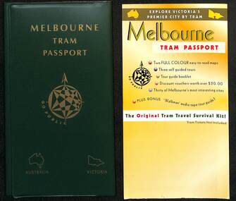
Booklet - Folder - sample, Go Public, "Melbourne Tram Passport", 1995
Possibly a sample of a product, Melbourne Tram Passport, that was compiled or put together by Go Public in 1995 as a promotion to use Melbourne trams and receive discounts at various venues. No evidence is known of its actual use in practice. On the last page of the Guide Book are the names of David Miller and Frank Pallay and Go Public's Elsternwick PO Address. Similar to the "Melbourne Met Pass" of 1988 - see item 2843 Yields information about the concept of a tourist travel promotion using Melbourne's trams.Green plastic partitioned folded containing sample tickets, map, pamphlet and guide books.trams, tramways, melbourne tram passport, tickets, the met, public transport -
 Melbourne Tram Museum
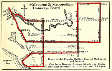
Drawing - Digital Image, Shilling Tour Map, 1927
Map shows the route of the Shilling Tour Map, using Y469 - shows the direction of travel and departure times from Batman Ave. Destination City 5th Edition notes that the services with the tram commenced in June 1927.Yields information about the MMTB's 1927 Shilling tour of Melbourne.Digital Image of an MMTB Map.trams, tramways, y class, tours, tourist trams, tourist trips, tram 191 -
 Melbourne Tram Museum
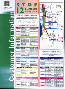
Poster, Swanston Trams, "Swanston Trams - Stop 12 Flinders Street", 1999
Poster - "Swanston Trams - Stop 12 Flinders Street" - giving frequency information for routes 3, 16, 1, 5, 64, 6, 67, 72 and 8 - all the Swanston St routes. Has a map insert showing these routes and interchanges with rail lines. Gives The Met information centre contact details, along with Swanston's website. Understood this was a proposal, but not actually used. Demonstrates timetable information board layouts - not actually used.Special size sheet printed in full colour and laminated.tramways, swanston trams, timetables, poster, stop information, signs, swanston st -
 Melbourne Tram Museum
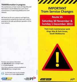
Pamphlet - Tram Service Change - Route 55, Public Transport Victoria (PTV), 11/2013
Issued for track work in Kingsway and Park St South Melbourne, route 55, undertaken between 30/11/2013 and 1/12/2013. Has a map showing the work zone, mainly in Park St and buses between the city and Domain Interchange and tram service changes. Produced by Yarra Trams and the PTV.Yields information about track work in Park St South Melbourne during 2013.Pamphlet - full colour DL two fold, printed on light card.trackwork, park st, route 55, kingsway -
 Melbourne Tram Museum
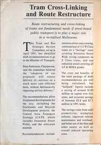
Document - PTC, Public Transport Corporation (PTC), "Tram cross-linking and route restructure", c1991
Provides proposals to link cross Melbourne tram routes together, eg Glen Huntly road routes with West Brunswick. The proposal did not proceed. Gives details of the proposals, those routes not to be linked, maps, looks at each of the linked routes. Predicated $100 million in savings. Part of the Tram and Bus Strategic Review Committee work. c1991.Yields information about proposals to link Cross city Melbourne tram routes.Five A4 page document, stapled in top left hand corner.melbourne, public transport, tramways, tram routes, linking routes, cross linking -
 Melbourne Tram Museum
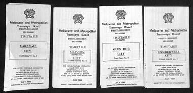
Ephemera - Timetables - MMTB trams - set of 10, Melbourne & Metropolitan Tramways Board (MMTB), 1973
MMTB Timetables - providing information on ticketing, fares, and timing points, with a description of the route and a map. Includes routes via William St - in the 30s 1 - East Malvern - City - route 3, bus route on Sundays only - June 1973 2 - Malvern Burke Road - City - route 5 and 35, - June 1973 3 - Glen Iris - City - route 6 and 36 - Sept. 1973 4 - Toorak - City - route 8 and 38 - June 1973 5 - South Melbourne and St Kilda Beach - City - routes 10, 12, and 17 - June 1973 6 - St Kilda Beach - South Melbourne Beach - City - routes 15, 16, 53, 55, 1, 2 and 4 - Sept. 1973 7 - Moreland - East Coburg - City - routes 1, 21, 15 and 22 - August 1973 8 - East Brighton - City - routes 64, 65, 62 and 61 - June 1973 9 - Carnegie - City routes 67, 37 and 66 - June 1973 10 - Kew Cotham Road - St Kilda Beach - route 69 - June 1973Yields information about MMTB tram services during 1973Set of 10 MMTB tram timetables - multifolded printed on yellow paper.timetable, mmtb, glen iris, malvern town hall, toorak, route 36, route 8, route 38, route 10, route 12, route 17, route 3, route 5, route 35, route 6, route 1, route 2, route 4, route 21, route 15, route 22, route 64, route 65, route 61, route 62, route 67, route 37, route 66, route 69 -
 Melbourne Tram Museum
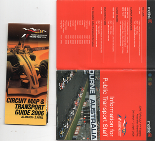
Booklet, Metlink, "Information for public transport staff - 2006 Formula 1 Australian Grand Prix", 2006
... program and transport map, including shunting details ...Gives details of event for train, tram and bus crews, event program and transport map, including shunting details, announcements, bus replacement services, electric or automatic points, route alterations. On the back cover has contact telephone numbers and web addresses - Published by Metlink. Fold out map gives a detail map of the course, locations for transport and details of the event - published by the Grand Prix corporation. Yields information the 2006 Grand Prix event at Albert Park.Set of 2 items - both within a clear plastic envelope. 1 - booklet 40 pages with foldout map centre stapled 2 - 16 fold map - circuit map and transport guide tramways, grand prix, metlink, formula 1, albert park -
 Melbourne Tram Museum
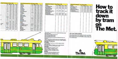
Pamphlet, The Met, "How to track it down by tram on The Met", mid 1980's
Fold out pamphlet, 7 folds, titled "How to track it down by tram on The Met", early 1980's, with a map of the tram system, The Met logos, providing information about tram services to specific locations. Also provides details of first and last trams for all tram routes and service frequency. Second copy added 17-4-2017trams, tramways, melbourne, map, tram services, the met -
 Melbourne Tram Museum
Ephemera - Set of 24, Melbourne & Metropolitan Tramways Board (MMTB), "MMTB Tram Timetables", 1969
Set of 23 timetables for specific routes, day of week giving information on tram times at specific time points, route map, sections and fares and organisation address - 616 Little Collins St. Melbourne. All July 1969. The first set of timetables issued in this format. 1- Route 4 - Carnegie - City 2 - Route 5 - Malvern (Burke Rd.) - City 3 - Route 6 - Glen Iris - City 4 - Route 7 - Camberwell - City 5 - Route 8 - Toorak - City 6 - Route 9, 10 and 12 - South Melbourne and St Kilda Beach - City 7 - Routes 10, 11, 9 and 9A - West Preston Northcote - City 8 - Route 1, 2A, 15, 16 - St Kilda Beach - South Melbourne - City 9 - Route 1, 15, 21, 22 - Moreland - East Coburg - City 10 - Route 19 - North Coburg - City 11 - Route 42 - Mont Albert - City 12 - Route 48, 74 - North Balwyn - Burwood - City 13 - ditto - Saturdays and Sundays - printed on pink paper 14 - Route 55, 56 - West Coburg - Domain Road - via William St 15 - Route 57 - West Maribyrnong - City - bus route Sundays only 16 - Route 59 - Essendon Aerodrome - City 17 - Route 64, 65 - East Brighton - via Swanston St/ William St 18 - Route 69 - Kew Cotham Road - St Kilda Beach 19 - Route 70 - Wattle Park - City 20 - Route 77, 78, 79 - Prahran - City, North Richmond - Prahran - St Kilda Beach 21 - Route 82 - Footscray - Moonee Ponds - bus route Saturday afternoon and Sundays 22 - Route 88 and Route 96 - East Preston, East Brunswick - city - July 1969, printed on white paper. - Weekdays and Sundays 23 - Route 88, 96 - East Preston and East Brunswick (Blyth St)< Saturdays, Xmas day and Good Fri - printed on pink paper. 24 - Route 4D - East Malvern (Darling Road) - City, bus route Sundays only Yields information about MMTB Tram services during 1969Set of 24 MMTB Tram timetables, folded sheets.trams, tramways, mmtb, timetables, melbourne, fares, route 69, route 64, route 88, route 96, route 4, route 4d, route 5, route 6, route 7, route 8, route 9, route 9a, route 10, route 11, route 12, route 1, route 15, route 21, route 22, route 2a, route 15, route 16, route 19, route 42, route 48, route 74, route 55, route 56, route 57, route 59, route 65, route 70, route 77, route 78, route 79, route 82 -
 Melbourne Tram Museum
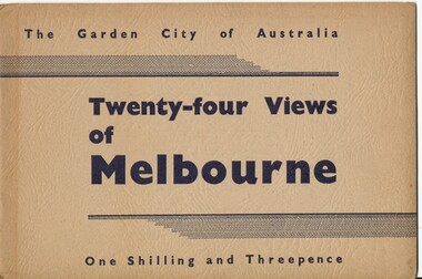
Book, Victorian Government Information Bureau?, "The Garden City of Australia / Twenty-four views of Melbourne", c1950
Book, brown cover patterned (Deer skin?), titled "The Garden City of Australia / Twenty-four views of Melbourne" with 24 pages (smaller than cover) printed pages stapled inside. Inside front cover is a map of Melbourne, with specific buildings marked, inside rear cover - Where to go in Melbourne, General Information and Sight seeing tours. On rear cover is printer details. Page Photo details by 1 Skyline of the City of Melbourne from Yarra Bank Victorian Railways 2 Collins St from Spring St (with trams) ditto 3 Princes Bridge, River Yarra ditto 4 St Kilda Rd from Flinders St Station ditto 5 St Pauls Cathedral ditto 6 Bourke St Shopping Centre - with double deck buses no details of photographer 7 Elizabeth St - with trams and buses Victorian Railways 8 Swanston St with modern skyscrapers (Collins) ditto 9 Aerial view, city of Melbourne ditto 10 Parliament House ditto 11 Public Library, Museum and Art Gallery ditto 12 St Kilda Rd, Looking towards the City trams 772 and W2 ditto 13 Kings Domain - Pioneer Monument ditto 14 Royal Melbourne Hospital - with back view inset ditto 15 Alexandra Gardens and the Shrine of Remembrance ditto 16 Alexandra Gardens and Government House ditto 17 Captain Cook's House - Fitzroy Gardens ditto 18 Albert Park Lake no details of photographer 19 Melbourne Boys School, MacRobertson's Girls High School and Melbourne Uni - no details of photographer 20 Scene in the Botanical Gardens Victorian Railways 21 Aerial view of St Kilda with Brighton in background Victorian Railways 22 Melbourne Cricket ground, taken during the testimonial match to Sir Donald Bradman - no details 23 Queen Victoria Memorial Hospital and Exhibition Buildings and Aquarium - Victorian Railways 24 Dandenong - Showing Silvan Dam Victorian Railways The testimonial match took place in Melbourne during December 1948 (Reference Sir Donald Bradman Museum). Possibly arranged by the Victorian Government Information Bureau given the number of Victorian Railways photographs.trams, tramways, melbourne, st kilda rd, swanston st, bourke st, victorian railways, flinders st station, gardens -
 Melbourne Tram Museum
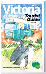
Map, Surveyor General for the Victorian Tourism Commission, "Victoria Australia Tourist Guide", 1985
Folded map of Victoria, showing in colour relief Victorian area, national parks, highways, towns, railways, airport, wine growing areas, towns with information centres, historic parks, ski fields. NSW and SA show major towns and highways. Front cover includes an image of a Z class tram and two penguins. Has town index. Folded 7 folds horizontally by 3 folds deep. On rear is a listing of locations with major tourist destinations provided. Provides location of VicTour offices. Prepared by the Surveyor General for the Victorian Tourism Commission, printed by the Government Printer, 4th edition 1985.trams, tramways, victoria, map, victour, tourism