Showing 2634 items
matching otway-reef
-
 Apollo Bay Museum
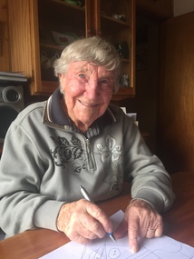
Audio - Bill Hurley Fraser Oral History Interview Apollo Bay May 2023
Local Otways residents (Gadubanud Country) were interviewed by artist/researcher Amy Tsilemanis for the 2023 storytelling project Heart Maps, a collaboration with the Apollo Bay Museum and Historical Society. Themes include memories of communication technologies, entertainments, school, work, community, and life near the ocean. More information here: https://amytsilemanis.com.au/portfolio/heart-mapsapollo bay, fishing, seafood -
 Apollo Bay Museum
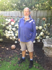
Audio - Val Flitton Oral History Interview Apollo Bay April 2023
Local Otways residents (Gadubanud Country) were interviewed by artist/researcher Amy Tsilemanis for the 2023 storytelling project Heart Maps, a collaboration with the Apollo Bay Museum and Historical Society. Themes include memories of communication technologies, entertainments, school, work, community, and life near the ocean. More information here: https://amytsilemanis.com.au/portfolio/heart-mapsapollo bay, nursing, ww2 -
 Apollo Bay Museum
Audio - Russell Frost Oral History Interview, Apollo Bay, April 2023
Local Otways residents (Gadubanud Country) were interviewed by artist/researcher Amy Tsilemanis for the 2023 storytelling project Heart Maps, a collaboration with the Apollo Bay Museum and Historical Society. Themes include memories of communication technologies, entertainments, school, work, community, and life near the ocean. More information here: https://amytsilemanis.com.au/portfolio/heart-mapsapollo bay, fishing, seafood -
 Bendigo Historical Society Inc.
Document - MCCOLL, RANKIN AND STANISTREET COLLECTION: SUNDRY REPORTS, 1930's
Manilla Folder containing reports from various mines in Bendigo and surrounding areas. 1. 4 page typewritten report on the Balaclava Hill Mine at Rushworth and some newspaper clippings about the mine with a plan of the underground workings; 2. Page from the Árgus' dated 2nd August 1900 featuring an article on the survey of the Garden line of Reefs; 3. 5 page report with maps on the Tooleen Gold Field; 4. Single page report about an unnamed mining area claimed to be on the southern end of the Deborah line of reef. (this could be the 'Three Jays' mine in Sedgwick. P. Wilkin); 5. Hand written report on the Coronation Mine, 2 miles east of Walhalla.; 6. Hand written report dated 1935, of the Queen Mary mine, St. Arnaud.; 7. 1932 report on the North Neangar lease.; 8 4 page report on the Kings Prize Gold Mining Syndicate.; 9. Description of the plant of the Marong Alluvial Company? Also a guide for marking out leases.; 10. Crushing details (1 page) from the 'Enterprise' Mine South of and adjacent to Perseverence.; 11. 1 page crushing details from Rowe Brothers, Mosquito Mine, Fryerstown.; 12 hand written report mentions Arthur Hatfield, Scarsdale.; 13. Map with lines of reef showing the position of the New Moon Consolidated and the New Moon United shafts.; 14, Large scale map from Harrison/Victoria street to Havilah Road showing the positions of the Carlisle, North Garden and Unity Shafts.gold mining, miners' safety cage, sundry reports, mining. bendigo, rushworth, balaclava hill, garden line of reef, toolleen, coronation mine, walhalla, queen mary mine, st. arnaud. north neangar, kings prize gold mining syndicate, marong, enterprise mine, perseverence, rowe brothers, mosquito mine, fryerstown, arthur hatfield, scarsdale, new moon consolidate, new moon united, carlisle, north garden, unity. -
 Bendigo Historical Society Inc.
Map - SECTIONS ACROSS BENDIGO GOLDFIELD
Map in three sections showing sections across Bendigo Gold Field, showing anticlines, synclines, faults, stratigraphical zones and mines along the reef lines. Key shows rock types Castlemaine, Bendigo B1, B2, B3 and B4, and Lancefieldian. First part of map shows sections A-A, B-B and C-C. Reef lines drawn with mines listed: Fault line shown are the Carshalton, Stafford, New Chum, Virginia and Clarence. A datum line shows 600 ft above sea level. On bottom of plan: ' Prepared in the Geological Survey Office, Bendigo, under the direction of H. Herman, late Director of Geological Survey, from surveys by H.S. Whitelaw, Field Geologist, assisted by E.S. Usher, A.J.J. Moore and R.A. Keble.' Second section of map shows sections D-D, and E-E. Fault lines listed are the Tambour Major fault, Carshalton fault, Stafford fault, Nell Gwynne fault, New Chum fault, Deborah fault. Third section shows sections F-F and G-G. Fault lines listed are the Bird Reef fault, Kangaroo Gully fault, Langdon fault, Carshalton fault, Nell Gwynne fault, Spring Gully fault, Hustlers fault, Gravel Hill fault, Ordes fault, Thanet fault. This map forms part of the Geological Survey of Victoria, Structure of Bendigo Goldfield report, No. 47, 1923. H.Herman, late Director of Geological Survey.Geological Survey of Victoriabendigo, gold mining, reef line maps -
Bendigo Historical Society Inc.
Document - NEW CHUM RAILWAY MINE - GOLD MINES OF BENDIGO & EAGLEHAWK
Handwritten notes on the New Chum Railway Mine and other mines and connections between various mines underground. Descriptions of mines and their equipment. Mines mentioned are: New Chum Railway Mine, Eureka Extended, Shenandoah, Shamrock Mine, Young Chum, Old Chum, Little Chum, New Chum Tribute, Cravens, Garibaldi, New Chum Consolidated, Menzies, Ellesmere, Consolidated, Denis, Lansell's 222, New Chum United, Kochs & Hildebrandt Mine, Lazarus, Central Blue, Lazarus No 1 Coy, Hudson's, Burrows & Sterry, Victoria Tribute, North Old Chum, Lansell's Big 180, Sandhurst, Victoria Quartz, The Great Central Victoria (known as the 'Midway'), Victoria Consols, Advance, Adventure, Ironbark, Victoria Gold Mines Company, No 83 claim, The Hercules & Energetic, North Energetic, Victoria Pilot, Bendigo Amalgamated Goldfields Company, Pearl, Hercules No 1, Hercules New Chum, Great Extended Victoria, New Victoria Catherine, Mystery (later the Duke of Edinburgh), New St Mungo, Duchess Tribute, Extended South Devonshire, South Devonshirte, Duchess of Edinburgh, Princess Alexandia (later United Devonshire), Danes, United Devonshire, South Devonshire, Hopewell, Phoenix, Unicorn, Lady Barkly, Sadowa, Eastwood Lease, Ellenborough, Belmont & Saxby, York & Durham, Acadia, Williams United, Ulster, North Red White & Blue, North Deborah, Catherine Reef United, Central Catherine, Princess Alice, Catherine Reef United, Murchison, North Catherine (or Franklin), Catherine Reef Extended,document, gold, gold mines of bendigo & eaglehawk, new chum railway mine, gold mines of bendigo & eaglehawk, eureka extended, shenandoah, shamrock mine, young chum, old chum, little chum, new chum tribute, cravens, garibaldi, new chum consolidated, menzies, ellesmere, consolidated, denis, lansell's 222, new chum united, kochs & hildebrandt mine, lazarus, central blue, lazarus no 1 coy, hudson's, burrows & sterry, victoria tribute, north old chum, lansell's big 180, sandhurst, victoria quartz, the great central victoria (known as the 'midway'), victoria consols, advance, adventure, ironbark, victoria gold mines company, no 83 claim, the hercules & energetic, north energetic, victoria pilot, bendigo amalgamated goldfields company, pearl, hercules no 1, hercules new chum, great extended victoria, new victoria catherine, mystery (later the duke of edinburgh), new st mungo, duchess tribute, extended south devonshire, south devonshirte, duchess of edinburgh, princess alexandia (later united devonshire), danes, united devonshire, south devonshire, hopewell, phoenix, unicorn, lady barkly, sadowa, eastwood lease, ellenborough, belmont & saxby, york & durham, acadia, williams united, ulster, north red white & blue, north deborah, catherine reef united, central catherine, princess alice, catherine reef united, murchison, north catherine (or franklin), catherine reef extended, mr clark magee, john delbridge - engineers, a harkness & sons, mr lansell, b c v 8 studios, mr gibbs, mr barnet lazarus, mt alvernia hospital, p m g repeater station, john brown knitwear, mr burrows, mr sterry, john wybrants, mr wittschiebe, theodore ballerstadt, mr wm rae, california hill state school, freeman & coy -
 Stawell Historical Society Inc
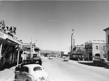
Photograph, Main Street Stawell looking West towards the Town Hall, on the right c 1960's
Main Street Stawell looking West including Town Hall Shops and Motor Vehicles c 1960's. This photo was taken by M. Robson before being donated to the society. The photo of Main St. was taken before it was made into a Mall, now know as "Gold Reef Mall". The street reopened to traffic in 2005.Black & white photograph of Main St Stawell looking towards the Grampians. The view includes the Town Hall & Bank of Australia on the right, with shops either side and two vehicles travelling along the road with vehicles parked along the street c 1960's.stawell business streetscape -
 Queenscliffe Maritime Museum
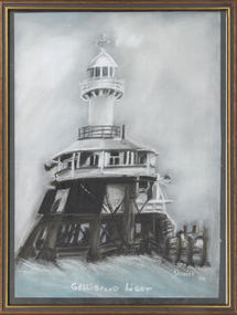
Painting - Pastel painting of the Gellibrand Light, Gellibrand Light
The reef off Point Gellibrand at Williamstown was lit for nearly 120 years by a series of lights, beginning with three separate lightships over the mid-late 1800s, to a pile light which lasted seventy years before it was dramatically destroyed when hit by a ship the Melbourne Trader on the foggy morning of 21 June 1976.A pastel painting of the Gellibrand Pile Light made by Denise Clarke in 1999.Gellibrand Light; Denise '99point gellibrand pile light -
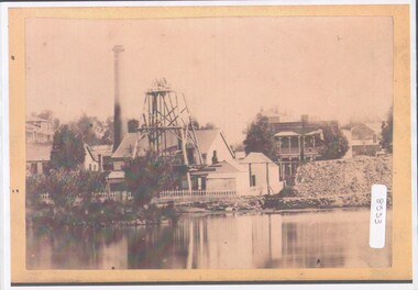 Bendigo Historical Society Inc.
Photograph - View of Hustler's mine
Named after Thomas Hustler who purchased the lease in 1854. It was an opencut mine at this stage and Hustler patented a quartz crushing machine. HE later sold the mine to the Hustlers Reef Mining and drainage Co. and by 1865 the Great Extended Hustler's was operating 31 levels at a depth of 1053meters. The mine ceased operation in 1921.A4 copy of an original photograph, sepia toned print. View of hustler's Mine facing Barnard Street, Bendigohustler's, barnard street, james brierley -
 Bendigo Historical Society Inc.
Document - MCCOLL, RANKIN AND STANISTREET COLLECTION: ASSAY CERTIFICATES, 1930's
Manilla Folder Held together with brass pins containing Assay Certificates from S. R. Mitchell & Co. Pty Ltd. The Majority of them are for L. C. Stuckey Esq. 199 Barker Street Castlemaine and a few of them are for Sir Herbert Gepp 422 Collins Street Melbourne. Also contains a list os samples taken from Reefs near the Devonshire Mines Castlemaine. The Dates range from 1935 to 1937.S. R. Mitchell & Co., Pty, Ltd. Metallurgists. 399 Little Colins Street, Melbourne.gold, mining, metallurgists, gold mining, castlemaine, s.r. mitchell, l.c. stuckey, sir herbert gepp -
Bendigo Historical Society Inc.
Document - MARKS COLLECTION: UNDERGROUND SURVEY OF MINES NEW CHUM LINE OF REEFS
Plan, in two sections , on heavy parchment coloured paper. Printed across top in black ink 'Underground Survey of Mines New Chum Line of Reefs' a. Shows cross section of mine , b. longitudinal section. Drawn by Arthur Everett, Mining Department, Melbourne 1884. Surveyed by Caleb Thomas under the direction of Charles Langtree. Plan found in George Lansell auction items. Plan found in George Lansell items sold at auction.bendigo, mining, new chum reef -
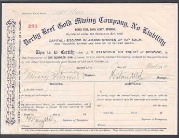 Bendigo Historical Society Inc.
Document - BOOTH ST MCKENZIE MINING
Derby Reef Gold Mining Company No Liability scrip dated 4th April 1912 certifying that J G Stanfield holds 100 shares in above-named company located in Long Gully, Bendigo. Capital of 20,000 pounds in 40,000 shares at 10 shillings each. J G Stanfield signature indicates he was manager of above -named company. Director signatures illegible. Scrip pasted upon cardboard backing. Unknown donorbendigo, gold mining, j g stanfield -
Bendigo Historical Society Inc.
Photograph - AGNEW HUSTLERS - PHOTO OF AGNEW HUSTLERS
Black & white photo (mounted on light brown heavy paper)of the Agnew Hustlers. Written beside the photo: Agnew Hustlers, later North Hustlers. Kneebone St. Depth 402'. (feet). No gold (water). Probable depth of Reef 560'. Photo is a small black & white one of the wooden poppet legs with a shed behind it and some trees. On the bottom left edge, there is a man standing (partly obscured) with his hand on his hip.photo, agnew hustlers, north hustlers -
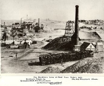 Bendigo Historical Society Inc.
Photograph - HUSTLER'S LINE OF REEF
Black and white photograph of mining landscape with poppet head, chimney and mining sheds (plus timber in stack) in foreground. Other mines in bare landscape on LHS background and housing on RHS background. Inscriptions: on front - 'The Hustler's Line of Reef from Redan Hill Hustler's Tribute Coy', 'Gt. Extended Hustler;s Claim', 'The Old Hustler's Claim, Gt. Hustlers (Late Latham & Watson's). On back - 'A Richardson, 29 Harrison Street, Bendigo'.mine, gold, hustlers reef mine, bendigo, mines and mining, mine, mines, mining, landscape, mining landscape, redan hill, poppet head, old hustlers, mining cottages -
 Bendigo Historical Society Inc.
Document - CORRESPONDENCE TO BHS RE: CROCKER FAMILY
Correspondence to BHS re Crocker family - lived in Bendigo 1869 - 1912. Manager - Hustlers Reef mine. Reply from BHS: ''1891 - Mr Crocker was a member of the Mining Board''. A bracketed comment makes reference that the Mr. Crocker referred to in this letter may not have been the to which you refer. The reply make reference to a Mr. Crocke who attended the opening service of the Wesleyan School-house, situated at View Point Sandhurst.person, individual, crocker family, james thomas croker, king edwards, hustlers reef mine, mining board, wesleyan school-house, view point sandhurst. -
Bendigo Historical Society Inc.
Map - FORTUNA HUSTLER'S MINE - TRANSVERSE SECTION OF THE FORTUNA HUSTLER'S MINE
Transverse Section of the Fortuna Hustler's Mine on the Hustler's Line of Reef, Bendigo. Bulletin No 33, Plate No III. Drawing shows poppet legs on the surface and Sill of Shaft 745.38 feet above Sea Level. Shows levels and their depths, geographical features and stone encountered. Reference table to stone and geographical features. Geographical Survey of Victoria emblem. Signed by H A Whitelaw, Underground Survey Office, Bendigo. This item has not been scanned or photographed.mining, parish map, fortuna hustler's mine, hustler's line of reef, geological survey of victoria, underground survey office bendigo, h a whitelaw -
Bendigo Historical Society Inc.
Document - SOUTH NEW MOON MINE - PRODUCTION FROM THE SOUTH NEW MOON MINE
Handwritten notes on the South New Moon Mine. Notes include depth of shaft, years, Calls, Dividends, Ounces of Gold, Authority and Remarks. Names mentioned:- Beavis (Beavis & Co), Paul & Co (Pahl), Bassett's Claim, J. P. Graham, South New Moon Co, South New Moon Trib West Line, Hart's Moon Reef Trib, Ashman's Trib East Line, South New Moon and Protectin Co.document, gold, south new moon mine, south new moon mine, beavis (beavis & co), paul & co (pahl), bassett's claim, j p graham, south new moon co, south new moon trib west line, hart's moon reef trib, ashman's trib east line, south new moon, protection co, garden gully -
 Bendigo Historical Society Inc.
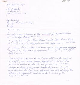
Document - MCCOLL, RANKIN AND STANISTREET COLLECTION: DEBORAH GOLD MINES NL- WAGES BOOK, 1945-50
Document: McColl, Rankin and Stanistreet: Deborah Gold Mines NL - wages book various mining companies. Hardcover, green. Wages and tax paid for employees of North Deborah, North Deborah Battery 1 and 2, Nell Gwynne Reef, North Virginia, Central Deborah, Deborah Gold Mines, Deborah Battery, Central Nell Gwynne, North Deborah Battery No. 3. On front cover in gold ' Collins Analysis Book, 27 sets'organization, mining, mccoll, rankin and stanistreet, mccoll, rankin and stanistreet: deborah gold mines nl, gold mining, bendigo, wages book -
 Bendigo Historical Society Inc.
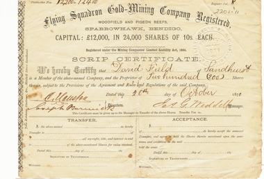
Document - LANSELL COLLECTION: SCRIP CERTIFICATE: FLYING SQUADRON GOLD-MINING COMPANY REGISTERED, 1870
Document: 2 copies of Scrip certificates from Flying Squadron Gold-Mining Company Registered, Woodfield and Pigeon Reefs, Sparrowhawk, Bendigo. Issued to David Field of Sandhurst, 26th. October, 1870. Signed by J.G. Weddell, Manager. David Field is listed as an original shareholder in the Flying Squadron Mine, in 1870. ( see Government Gazette October 7, 1870 ) The mine was situated at Sparrowhawk Gully, Sandhurst. ** one copy only in pocket. 8.10.2019place, fortuna, family history, bendigo, sandhurst, fortuna, lansell, david field -
 Bendigo Historical Society Inc.
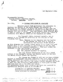
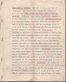
Document - MCCOLL, RANKIN AND STANISTREET COLLECTION: MEMORANDUM OF AGREEMENT GREAT EASTERN AND BIRDS REEF, 10/2/1933
Document: McColl, Rankin & Stanistreet , 7 page document, typed, prepared by Ford Aspinwall & DeGruchy, Solicitors, Melbourne. Memorandum of agreement between Great Eastern and Birds Reef No Liability syndicate and New Don No Liability. Signed under common seal of New Don James Barclay and Geo. Kingsley ( director ) and Stanistreet ( legal manager ) Also asigned by Jack Reginald Ingram, Thomas Watson Haynes and Henry George De Gruchy.organization, business, new don no liability, mccoll, rankin & stanistreet , great eastern and birds reef no liability syndicate, new don no liability, bendigo, gold, goldmining, lease -
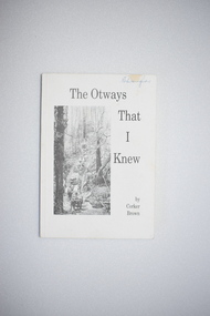 Warrnambool and District Historical Society Inc.
Booklet, Merimbula Easiprint, 1993
This book was written by Roland (Corker) Brown. His forebears were pioneers in the Wyelangta area of the Otway Ranges and he spent most of his life in that region. In this book he has recorded some of the history of the area and his personal recollections, starting from the 1930s when the last of the bullock and horse teams were transporting timber and the old mills were closing. This book is of interest as it gives the history of the Otway Ranges and one man’s story of life in this region in the early to mid 20th century. It will be useful for researchers. This is a soft-cover book of 211 pages. It has a white cover with a black and white photograph of a bush scene and black printing on the front cover. The book contains a poem by the author, two sections of printed material and many black and white photographs. -
 Flagstaff Hill Maritime Museum and Village
Functional object - Wood sample, circa 1840
This oak wood sample is part of the wooden barque, the Grange, built in 1840. The wood sample was recovered from the shipwreck of the Grange in around 1968, 110 years after the Grange was wrecked (see below for further details on the Grange). It is part of the John Chance Collection. THE GRANGE, 1840-1858- The wooden barque ’Grange’ was a three-masted ship built in Scotland in 1840 for international and coastal trade. On March 22, 1858, the Grange set sail from Melbourne under Captain A. Alexander, carrying a cargo of ballast. The barque had left the Heads of Phillip Bay and was heading west along the Victorian coast towards Cape Otway. The ship struck Little Haley’s Reef at Apollo Bay due to a navigational error and was stuck on the rocks. The crew left the ship carrying whatever they could onto the beach. Eventually, the remains of the hull, sails and fittings were salvaged before the wreck of the Grange broke up about a month later. About 110 years later, in 1968, the wreck of the Grange was found by divers from the Underwater Explorers Club of Victoria. They were amazed to find a unique, six to nine pound carronade (type of small cannon) and a cannonball on the site. There have been no other similar carronades recorded. In that same year the anchor of the Grange was recovered by diver John Chance and Mal Brown. The wood sample is significant historically as an example of hardware used when building wooden ships in the early to mid-19th century. The sample is historically significant as an example of the work and trade of blacksmith. The sample is also has significant as it was recovered by John Chance, a diver from the wreck of the Grange in the 1968. Items that come from several wrecks along Victoria's coast have since been donated to the Flagstaff Hill Maritime Village’s museum collection by his family, illustrating this item’s level of historical value. The sample is historically significant for its association with the 1840s wooden barque, the Grange. The Grange is an historical example of a Scottish built vessel used for international and coastal trader of both cargo and passengers in the mid-19th century. The Grange is an example of an early ship, designed with a wooden hull. It is significant as a ship still available to divers along the south coast of Victoria, for research and education purposes. The Grange is an example of a mid-19th century vessel that carried a weapon of defence onboard. Wood sample, oak wood fixed between plates and secured by a washer and bolt. There are five layers, each decreasing in size from base to the top. The bottom is a five-sided copper plate, above it is the oak sample that is crumbling and fragile, then a half-disc metal plate, then a square metal washer, then a round metal bolt head. The metal plate has unequal sides, the longest is parallel to the strait side of the half disc. flagstaff hill, warrnambool, flagstaff hill maritime museum, maritime museum, shipwreck coast, flagstaff hill maritime village, great ocean road, west coast trader, apollo bay, mid-19th century shipwreck, the grange, scottish barque, little henty reef, captain a alexander, underwater explorers club of victoria, 1840s carronade, vhr 5297, coastal trader, wooden shipwreck, john chance, wood sample, wooden ship, oak timber, ship fitting -
 The Beechworth Burke Museum
Photograph, Unknown
The A1 Gold Mine is located north of Woods Point, near Jamieson, in the Upper Goulburn region of Victoria. Gold was discovered at the A1 site in 1861 and mining operations began in 1864. The A1 Mine Settlement refers to a small township known variously as Castle Reef, Castle Point, and Raspberry Creek, which developed in the 1860s around mining industry centred on a crushing machine that worked the three gold reefs in the area. Historically, the name "A1"referred to the high quality of gold found in the quartz reefs at depths of at least two thousand feet. Along with the Morning Star mine at Woods Point, the A1 gold mine produced almost sixty percent of Victoria's gold output in the 1950s to 1970s and continued operating until 1992 when it went into administration. Operations at the site were revived in 2016 and the A1 Mine is now considered one of Victoria's premier gold mines. The A1 mine is part of the extensive and prospective Lachlan Fold Belt, a north-west trending belt of tightly folded Early Devonian sedimentary rocks extending from New South Wales to Victoria. Mineralisation is hosted within or immediately adjacent to diorite dykes. Contemporary development of the 'Queens Lode' at the A1 mine signals a move from high-grade, narrow vein airleg mining into larger scale, mechanical mining designed to increase ore production volume. This original, undated photograph of the A1 Mine appears to depict an area or phase of disuse or abandonment. The aged and humble appearance of the cottage suggests association with the historical A1 Mine Settlement, therefore the image may have been taken prior to the 1950s-1970s revival period in which the A1 mine is known to have produced high gold yields. The photograph contributes to our understanding of the A1 Gold Mine's impact on the landscape and the social, environmental impacts of mining on communities and may be compared with others in the Burke Museum's extensive collection of mining photographs to deepen our understanding of mining in the Jamieson area.Black and white rectangular photograph printed on photographic paperReverse: 5577 / A1 Mine / Near Jamieson / Vic. /burke museum, beechworth museum, beechworth, gold fields, gold rush, victorian gold rush, mining tunnels, gold ming history, colonial australia, australian gold rushes, mining technology, beechworth historic district, indigo gold trail, indigo shire, upper goulburn shire, jamieson, woods point-walhalla goldfield, a1 gold mine, victorian high country, modern mining methods, orogenic gold province, gold mineralisation, devonian, dykes -
 Warrnambool and District Historical Society Inc.
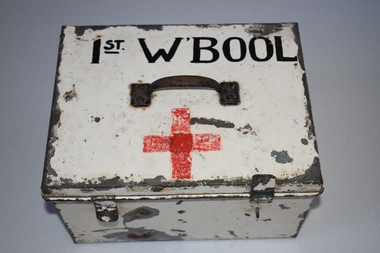
Tin, Mid 20th century
This is an old tin which has been used as a first aid box by a scout group in Warrnambool. It appears to date from about the 1950s. Today there are two scout groups in Warrnambool and one in Allansford. The Warrnambool Norfolk group has its headquarters at the corner of Raglan Parade and Kepler Street and the Warrnambool Tooram group has halls at the corner of Timor and Banyan Streets and in Otway Road. This tin is of minor interest as an item that belonged to a local scout group in the mid 20th century.This is a rectangular metal box painted cream but with the paint peeling. The metal handle is rusted and there are two metal catches. On the side is a red cross taped on and a red cross painted on the top. There is a black hand-painted name. Inside the tin are two metal pins to hold the catches and a divider in the middle.1st W’boolscouting in warrnambool -
 Orbost & District Historical Society
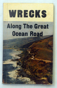
book, Wrecks Along The Great Ocean Road, 1976
Jack Kenneth Loney (21 October 1925 – 13 February 1995) was an amateur Australian marine historian who published over one hundred books and numerous newspaper and magazine articles. He was a schoolteacher and principal until his retirement. He became interested in maritime history after preparing several general history booklets covering the Otway region of western Victoria, Australia.This item is a useful reference tool.A 132 pp book with a coloured photograph of the Great Ocean Road, on the south-western coast of Victoria, on the front cover. The title. "Wrecks Along The Great Ocean Road" is in black print above the photograph. The book contains black / white photographs and sepia text.It lists and describes shipwrecks on the west coast from Point Lonsdale to Portland.shipwrecks-great-ocean-road-victoria shipping-history -
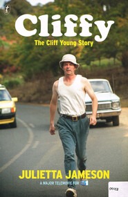 Otway Districts Historical Society
Book, The Text Publishing Company, Cliffy: the Cliff Young story, 2013
Cliff Young was a sixty-one-year-old potato farmer from Beech Forest in the Otway Ranges, a couple of hundred kilometres south-west of Melbourne. With his distinctive shuffle, friendly wave and innocent grin, he beat a field of professional runners to take out the inaugural Westfield Sydney to Melbourne Ultra-marathon starting on April 27 and finishing May 2 in 1983.Cliffy: the Cliff Young story. Julietta Jameson. 1st ed. Melbourne (Vic); The Text Publishing Company; 2013. vi, 218 p.; illus. ISBN 978 1922 0798 6 2 Soft covercliff young; beech forest; sydney; melbourne; ultra-marathon; otways; -
City of Kingston
Photograph - Colour, 31 January 1993
Patterson Lakes is a suburb in the City of Kingston that is built one kilometre upstream of the mouth of the Patterson River. The area is bordered by the Patterson River and Eel Race Drain which enters the Kananook Creek. The suburb consists predominantly of newer housing developments and the tidal canal system of the development joins Port Phillip Bay. Patterson Lakes and the Kananook Creek were previously part of the extensive Carrum Carrum Swamp. The area was once a source of fish and eels for the Mayone-Bulluk clan of the Bunurong people. Over time the area was drained and in 1973 investigations commenced into the development of a unique residential area that would be built adjacent to canals and waterways. It was originally proposed to be known as "Gladesville". The development would give the suburb's homeowners access to Port Phillip Bay "from their back door". Circa 1974, the area was rezoned from rural to residential and named Patterson Lakes. Development has been continuous since the 1970s with construction of residential housing, schools, shopping centres, marinas, a hotel and library.Laminated colour aerial photograph of the Carrum and Patterson Lakes region within City of Kingston. This 1993 image includes Patterson River Secondary College, Roy Dore Reserve, Kananook Creek and Nepean Highway. The railway line can be seen as it veers inland from Eel Race Road, Seaford. The section of Ocean Reef Drive and Palm Beach Drive in Patterson Lakes appears to be a recent development with many spare blocks and new houses under construction.Black typed lettering on white adhesive label: 31.1.93 Black typed lettering on white adhesive label: 27E/7140 31/1/93 12.55 pm Black typed lettering on white label: 7140 Yellow round adhesive label located on left sidepatterson lakes, seaford, kananook creek, carrum carrum swamp, canals and waterways -
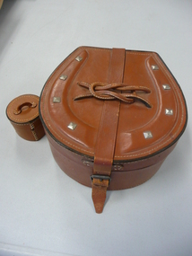 Bendigo Historical Society Inc.
Accessory - LEATHER COLLAR CASE
Leather collar case in a horse-shoe shape (impressed leather 'shoe' with 'nails' on top). Top has stiched leather thin 'rope' in the form of a reef knot over the leather strap that closes the box. Hinged with single leather strap. Lining is a fine blue cotton material. A central circular leather stud box with leather handle has broken away from the internal base (due to very firm fitting lid to box?). 1920s-1930s?personal effects, containers, collars -
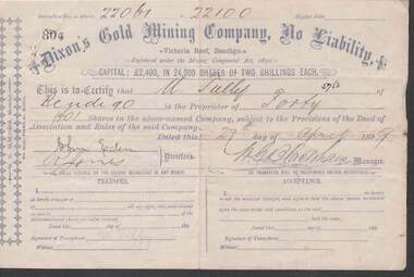 Bendigo Historical Society Inc.
Document - KELLY AND ALLSOP COLLECTION: SHARE CERTIFICATES - DIXON'S GOLD MINING CO, 08/11/1895 to 27/04/1899
Document. KELLY & ALLSOP COLLECTION. Two share certificates issued by Dixon's Gold Mining Company, No Liability, Victoria Reef, Bendigo. Both certificates issued to M.Tully of Bendigo. Certificate No. 439 - 100 shares @ 2 shillings each issued on 8 Nov.1895. Certificate No. 804 - 40 shares @ 2 shillings each issued on 27 April 1899. Capital raised was 2,400 Pounds from 24,000 shares. Each certificate signed by W.G.Blackham, Manager.Dixon's Gold Mining Co.business, stockbroker, kelly & allsop, kelly & allsop collection, share certificates, dixon's gold mining co., m.tully, w.g.blackham, victoria reef. -
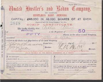 Bendigo Historical Society Inc.
Document - KELLY AND ALLSOP COLLECTION: SHARE CERTIFICATES - UNITED HUSTLER'S & REDAN COMPANY, 22/07/1912 to 26/10/1914
Document. KELLY & ALLSOP COLLECTION. 2 Share Certificates issued by the United Hustler's and Redan Company, Hustler's Reef, Bendigo. Each certificate represents 50 shares at One Pound each. Capital raised was 48,000 Pounds from 48,000 shares. Certificate No. 2848 issued to Arthur Allsop of Bendigo on 22 July 1912. Certificate No. 2620 issued to A.Allsop of Bendigo on 26 Oct 1914. Both certificates signed by Lea B.Birch, Legal Manager.United Hustler's & Redan Co.business, stockbroker, kelly & allsop, kelly & allsop collection, united hustler's & redan co., gold mining, share certificates, arthur allsop, lea b.birch