Showing 1860 items
matching the rock
-
 Mont De Lancey
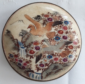
Accessory - Belt Buckle
Worn on a ladies belt for decoration. It could be Japanese as there are similar pieces on the internet.An antique round hand painted Japanese style ladies ceramic belt buckle with two birds, rock cliffs, flowers, two waterfalls and a mountain which could represent Mt Fuji in the background. It is mounted on a brass surround and the back has a hook for clasping to the other end of the belt and a thin metal bar. There is a small X signature stamped under the hook.A small X stamped on the back.belt buckles, belt accessories -
 Bendigo Historical Society Inc.
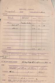
Administrative record - Sheepshead Shaft Fortnightly Statement Tonnage, 1917
Two buff coloured documents. On top of page: Fortnightly Statement, Sheepshead Shaft, Fortnight ending Nov. 7 and 24/10/17. Columns filled in include: mine or tributor, mill share delivered, loads and gold (if ascertained), footage, number of rock drill shifts and fuel used. Statement is part of the Margaret Roberts Collection of mining documents.bendigo, margaret roberts, , goldmining, sheepshead shaft, garden gully mill, wood burnt, fuel, rock drill shifts -
 Whitehorse Historical Society Inc.
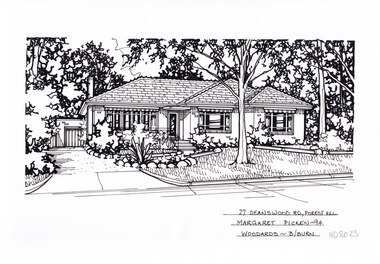
Artwork, other - Ink Line Drawing, Margaret Picken, 27 Deanswood Rd., Forest Hill, 1994
A property illustration by Margaret Picken Commissioned by the real estate agency Woodards Blackburn for the purpose of advertising 27 Deanswood Rd., Forest Hill This property is listed as having sold for $161,000 in 1994 Made by using Rotring ‘Rapidigraph’ drafting pens with Rotring ink on Rapidigraph polyester drafting film, double matte. Trained as a cartographic draftsman within the mining industry, Margaret Picken is an artist who worked producing property illustrations for real estate agencies in eastern suburbs of Victoria from 1983-2005. Retiring from the industry as technological changes favored coloured photography over illustrations, and commissioning companies over sole contractors.This artwork is of Historical Significance as a record of local domestic architecture.A black ink line drawing on drafters film by Margaret Picken, of 27 Deanswood Rd., Forest Hill. Of a one story house with a porch, steps and path leading up from the driveway on the left which leads to a detached garage in the background. A front yard with lawn, and rock edge garden beds. There are two hole punch holes along the top edge27 Deanswood Rd., Forest Hill Margaret Picken -94 Woodards B/Burnwhitehorse historical society, schwerkolt cottage, housing, architecture, margaret picken, house, garden, forest hill -
 Flagstaff Hill Maritime Museum and Village
Document - Navigation Chart, Admiralty Office, Lady Bay and Warrnambool Harbour, 03/04/1871
This Chart titled “Lady Bay and Warrnambool Harbour” was surveyed by Nav. Lieut. H.J. Stanley, of Britain's Royal Navy, in 1870 and printed in April 1871. The chart was made before the Warrnambool Breakwater was built (construction had begun in 1874 and was completed in 1890). The chart includes Directions for entering Lady Bay, Warrnambool Harbour. These are "Vessels entering Warrnambool Harbour must bring the Red Light in sight and steer in with it in line with the upper white Light bearing North, until the Green Light on the Jetty is opened, when steer towards it and anchor. The best anchorage is in 2 ¼ fms [fathoms)] of water, about a cable from ledge off Breakwater rock. Or where convenient, according to draught of water, only endeavouring to anchor as close as possible to Breakwater rock. It is not safe to enter or leave the Harbour in south westerly or Southerly gales.” This chart is significant for its strong connection to the maritime history of Warrnambool Harbour and Lady Bay, and eventually to the Warrnambool Breakwater. The Warrnambool Breakwater is registered as a place of significance on the Victorian Heritage Database (VHR H2024). A copy of the same chart was used to plan several submissions for future changes to the jetty and breakwater. The chart is a historical record of structures existing in 1870; the Warrnambool Jetties, Lady Bay, the leading lights (lighthouses), streets, roads, bridges and many buildings. It also shows the lay of the land and seabed.Canvas chart of Australia, South Coast, Victoria Title: Lady Bay and Warrnambool Harbour Surveyed by Nav. Lieut. H.J. Stanley, R.N., 1870. Magnet Variation, 1870 Published April 3, 1871, by the Admiralty, London. Directions for vessels entering Warrnambool Harbour are printed on the chart. The chart has a lacquer or seal over it.Top of chart has logo "HYDROGRAPHER OFFICE" "Price Eighteen Pence". "Engraved by Edward Weller" Along bottom of Chart: “London… Published at the Admiralty, 3rd April 1871, under the Superintendence of Rear Admiral G.H. Richards, F.R.S. Hydrographer, Corrections July 71” Bottom of chart “Australia South Coast Victoria Lady Bay and Warrnambool Harbour. 2494”flagstaff hill, warrnambool, chart of lady bay warrnambool 1870, warrnambool harbour, cartography, navigation, warrnambool breakwater, 1871, australia – south coast / victoria, lady bay, 1870, nav. lieut. h.j. stanley, r.n, directions for entering warrnambool harbour, hydrographer office, rear admiral g.h. richards, edward weller, port of warrnambool, flagstaff hill maritime museum & village, maritime museum, maritime village, shipwreck coast, map, chart, navigation chart, admiralty chart, breakwater, jetty, pier, vhr h2024 -
 Flagstaff Hill Maritime Museum and Village
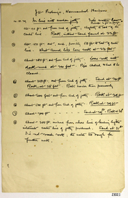
Document - Report, Jet Probings, Warrnambool Harbour, 16-10-1929
This report lists the depths of water and the consistency of the seabed surrounding the Warrnambool Harbour in October 1929, The information, often referred to as 'soundings', was obtained by Jet Probing,. In earlier days a lead line was used to perform a similar task. The author of the document is unknown. Jet Probing is a method used for underwater archaeology, cable installation and coastal engineering. A jet probe is a machine that produces a strong jet of water that penetrates the layers of sediment on the seabed, determining their depth, thickness and consistency. It provides a survey of the seabed and can be used as an aid to engineering design and construction. The report mentions lining up with the wooden jetty, the end of the breakwater and the leading lights. It mentions sand, loose rock and rock. It tells of stopping work due to the water being too rough, the pipe choking, difficulty in connecting pipes, and pipe joint breaking as it tried to get through the sand, The report in the document is significant for its connection with the Warrnambool Harbour, Warrnambool Breakwater, Warrnambool Jetty and Lady Bay. The report gives figures for the depth and consistency of the water and seabed at a particular point in time and can be used to compart with similar figures taken at different times. The results could determine plans for future engineering works.Report, titled 'Jet Probings, Warrnambool Harbour'. Two pages of cream coloured paper with hand written notes in pen and ink. Report covers three days of Jet Probings, with resulting figures and comments, for the depths of the surroundings of the Warrnambool Harbour. The report is in point form, with some underlining. Dates of recordings are 14-10-29, 15-10-29 and 16-10-29. (1929) The situation of the harbour had become a real problem by 1910 and required continuous dredging. In 1914 the Breakwater was extended but proved to be a failure because the work began to subside and by 1920 about two thirds of the harbour was silted up. Alterations made in the 1920's increased the silting problem. The soundings and Jet Probings were done after the Royal Commission of 1923, when the damaged stonework on the seaward side of the Warrnambool Breakwater, caused by the action of the sea, was the subject of enquiry. A conference between the Public Works, Water Commission and the Harbour Trust concluded that it would less costly to make repairs to prevent further damage rather than replaced the damage portion of the wall. A contract was raised in late 1924 to deposit rubble on the damaged side of the breakwater to minimise the Southern Ocean’s destructive action and work had started by August 1925. By the 1940's the harbour was no longer used. More alterations were made in the 1950's and 1960's. document, depth, warrnambool harbour, 1929, soundings, jet probe, jet probing, seabed, map of seabed, underwater engineering, warrnambool jetty, warrnambool breakwater, breakwater upgrade, leading lights, chart the harbour, flagstaff hill, warrnambool, flagstaff hill maritime museum & village, maritime museum, maritime village, shipwreck coast, lady bay, port of warrnambool, breakwater, jetty, pier, vhr h2024, royal commission, 1923, public works, water commission, harbour trust, victorian harbours -
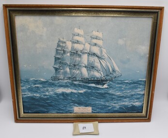 Geelong Naval and Maritime Museum
Photograph - Framed Picture, "Lightning", Unsure
Built by the celebrated shipbuilder Donald McKay, the Lightning was the first clipper built in the USA for a British firm. In 1862 on a return trip to Liverpool, it struck an uncharted rock in a rip. No water entered the vessel but on arrival a rock 6 feet long was found sticking through its timbers and beginning to work loose. Under Capt. 'Bully' Forbes, the Lightning made its first voyage to Australia in 77 days, and on its return voyage, made it in a record 64 days. The Lightning's entire life was spent on the Australian run carrying immigrants and cargo. It had the job of carrying free of charge immigrants and early consignments of introduced animals, including rabbits, which were sent to Thomas Austin of Barwon Park, Winchelsea. The wreck of ‘Lightning’ caused by fire was the worst shipping calamity in Geelong's history. Geelong's Centenary celebrations included a re-enactment of the burning of ‘Lightning’.Framed picture of ‘Lightning’ which is a ship particularly historic to the region of Geelong because of its story, the worst shipping calamity in Geelong's history.Framed Picture of ship "Lightning"lightning, geelong, ship wreck -
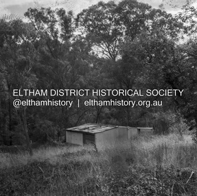 Eltham District Historical Society Inc
Negative - Photograph, J.A. McDonald, Road Reserve Housing, Mar. 1961
Shack built on road reserve without permit Most probably up on Simms Road, Kinglake Other areas where illegal shacks were built wer at the junction of Flat Rock Road and Cherry Tree Road, Hurstbridge. At times, Building Surveyor George E Newton would have to attend to these shacks for inspection and issue demolition ordersRecord of various Shire of Eltham infrastructure works undertaken during the period of 1952-1962 involving bridge and road reconstruction projects, sometimes with Eltham Shire Council Project Reference numbers quoted. It was during this period that a number of significant improvements were made to roads and new bridges constructed within the shire that remain in place as of present day (2022). In many situations, the photos provide a tangible visible record of infrastructure that existed throughout the early days of the Shire. The album was put together by or under the direction of the Shire Engineer, J.A. McDonald.infrastructure, shire of eltham, 1961-03, building surveyor, cherry tree road, flat rock road, george e. newton, houses, hurstbridge, kinglake, road reserve, road reserve housing, scan - 120 format 6x6 negative, shack, simms road -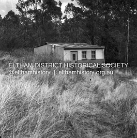
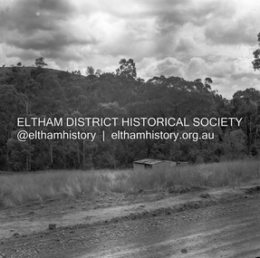 Eltham District Historical Society Inc
Negative - Photograph, J.A. McDonald, Road Reserve Housing, Mar. 1961
Shack built on road reserve without permit Most probably up on Simms Road, Kinglake Other areas where illegal shacks were built were at the junction of Flat Rock Road and Cherry Tree Road, Hurstbridge. At times, Building Surveyor George E Newton would have to attend to these shacks for inspection and issue demolition ordersRecord of various Shire of Eltham infrastructure works undertaken during the period of 1952-1962 involving bridge and road reconstruction projects, sometimes with Eltham Shire Council Project Reference numbers quoted. It was during this period that a number of significant improvements were made to roads and new bridges constructed within the shire that remain in place as of present day (2022). In many situations, the photos provide a tangible visible record of infrastructure that existed throughout the early days of the Shire. The album was put together by or under the direction of the Shire Engineer, J.A. McDonald.infrastructure, shire of eltham, 1961-03, building surveyor, cherry tree road, flat rock road, george e. newton, houses, hurstbridge, kinglake, road reserve, road reserve housing, scan - 120 format 6x6 negative, shack, simms road -
 Eltham District Historical Society Inc
Photograph, Alistair Knox Park, Eltham, c.1970, 1970c
View from northwest corner showing survey pegs for trees and two ponds. Main Road has been duplicated. Bridge Street intersection showing the rock wall on the east side of the original Main Road (Maria Street). Burgoyne's Store and Eltham Uniting Church in distance at centre right and Our Lady Help of Christians at centre left.In February 1968 an unknown person took a series of photos from the Eltham Hotel at Pitt Street heading north along Main Road through the shopping centre to just north of Elsa Court covering the length of the section of Main Road which was duplicated shortly thereafter. Shows the condition and environment of the streesscape of Main Road, Eltham immediately prior to the duplication between Pitt Street and Elsa Court through the shopping centre. Also shows a number of shops and businesses that operated at that time.Black and white photographduplication, eltham, main road, bridge street, burgoyne's shop, eltham uniting church, our ladys church, maria street -
 Flagstaff Hill Maritime Museum and Village
Functional object - Blotting Paper Holder, Circa 1910
Blotting paper is made from different materials of varying thickness, softness, etc. depending on the application. It is often made of cotton and manufactured on special paper machines. Blotting paper is reputed to be first referred to in the English language in the 15th century but there is a tradition in Norfolk, England that it was invented by accident at Lyng Mill on the River Wensum. It is reported that a Berkshire (England) paper mill worker in East Hagbourne failed to add sizing to a batch of paper that was being produced. The batch was discarded. Subsequently, someone tried to write on a piece of this discarded "scrap" paper and found that it rapidly absorbed any ink applied, making it unusable for writing. Its marked absorbency having been noted, however, led to its subsequently being produced and used as blotting paper, replacing sand, which was the material that had been used for absorbing superficial wet ink. In a time when most paper was produced from "rags", red/pink rags, from which it was difficult to remove all colour and had generally been discarded, were now directed to the production of blotters, hence the historically characteristic pink colour of blotters. https://en.wikipedia.org/wiki/Blotting_paper This blotting paper holder and blotting sheets were donated to Flagstaff Hill Maritime Village by the family of Doctor William Roy Angus, Surgeon and Oculist. It is part of the “W.R. Angus Collection” that includes historical medical equipment, surgical instruments and material once belonging to Dr Edward Ryan and Dr Thomas Francis Ryan, (both of Nhill, Victoria) as well as Dr Angus’ own belongings. The Collection’s history spans the medical practices of the two Doctors Ryan, from 1885-1926 plus that of Dr Angus, up until 1969. ABOUT THE “W.R.ANGUS COLLECTION” Doctor William Roy Angus M.B., B.S., Adel., 1923, F.R.C.S. Edin.,1928 (also known as Dr Roy Angus) was born in Murrumbeena, Victoria in 1901 and lived until 1970. He qualified as a doctor in 1923 at University of Adelaide, was Resident Medical Officer at the Royal Adelaide Hospital in 1924 and for a period was house surgeon to Sir (then Mr.) Henry Simpson Newland. Dr Angus was briefly an Assistant to Dr Riddell of Kapunda, then commenced private practice at Curramulka, Yorke Peninsula, SA, where he was physician, surgeon and chemist. In 1926, he was appointed as new Medical Assistant to Dr Thomas Francis Ryan (T.F. Ryan, or Tom), in Nhill, Victoria, where his experiences included radiology and pharmacy. In 1927 he was Acting House Surgeon in Dr Tom Ryan’s absence. Dr Angus had become engaged to Gladys Forsyth and they decided he further his studies overseas in the UK in 1927. He studied at London University College Hospital and at Edinburgh Royal Infirmary and in 1928, was awarded FRCS (Fellow from the Royal College of Surgeons), Edinburgh. He worked his passage back to Australia as a Ship’s Surgeon on the on the Australian Commonwealth Line’s T.S.S. Largs Bay. Dr Angus married Gladys in 1929, in Ballarat. (They went on to have one son (Graham 1932, born in SA) and two daughters (Helen (died 12/07/1996) and Berenice (Berry), both born at Mira, Nhill ) According to Berry, her mother Gladys made a lot of their clothes. She was very talented and did some lovely embroidery including lingerie for her trousseau and beautifully handmade baby clothes. Dr Angus was a ‘flying doctor’ for the A.I.M. (Australian Inland Ministry) Aerial Medical Service in 1928 . Its first station was in the remote town of Oodnadatta, where Dr Angus was stationed. He was locum tenens there on North-South Railway at 21 Mile Camp. He took up this ‘flying doctor’ position in response to a call from Dr John Flynn; the organisation was later known as the Flying Doctor Service, then the Royal Flying Doctor Service. A lot of his work during this time involved dental surgery also. Between 1928-1932 he was surgeon at the Curramulka Hospital, Yorke Peninsula, South Australia. In 1933 Dr Angus returned to Nhill and purchased a share of the Nelson Street practice and Mira hospital (a 2 bed ward at the Nelson Street Practice) from Dr Les Middleton one of the Middleton Brothers, the current owners of what previously once Dr Tom Ryan’s practice. Dr Tom and his brother had worked as surgeons included eye surgery. Dr Tom Ryan performed many of his operations in the Mira private hospital on his premises. He had been House Surgeon at the Nhill Hospital 1902-1926. Dr Tom Ryan had one of the only two pieces of radiology equipment in Victoria during his practicing years – The Royal Melbourne Hospital had the other one. Over the years Dr Tom Ryan had gradually set up what was effectively a training school for country general-practitioner-surgeons. Each patient was carefully examined, including using the X-ray machine, and any surgery was discussed and planned with Dr Ryan’s assistants several days in advance. Dr Angus gained experience in using the X-ray machine there during his time as assistant to Dr Ryan. When Dr Angus bought into the Nelson Street premises in Nhill he was also appointed as the Nhill Hospital’s Honorary House Surgeon 1933-1938. His practitioner’s plate from his Nhill surgery is now mounted on the doorway to the Port Medical Office at Flagstaff Hill Maritime Village, Warrnambool. When Dr Angus took up practice in the Dr Edward and Dr Tom Ryan’s old premises he obtained their extensive collection of historical medical equipment and materials spanning 1884-1926. A large part of this collection is now on display at the Port Medical Office at Flagstaff Hill Maritime Village in Warrnambool. In 1939 Dr Angus and his family moved to Warrnambool where he purchased “Birchwood,” the 1852 home and medical practice of Dr John Hunter Henderson, at 214 Koroit Street. (This property was sold in1965 to the State Government and is now the site of the Warrnambool Police Station. and an ALDI sore is on the land that was once their tennis court). The Angus family was able to afford gardeners, cooks and maids; their home was a popular place for visiting dignitaries to stay whilst visiting Warrnambool. Dr Angus had his own silk worm farm at home in a Mulberry tree. His young daughter used his centrifuge for spinning the silk. Dr Angus was appointed on a part-time basis as Port Medical Officer (Health Officer) in Warrnambool and held this position until the 1940’s when the government no longer required the service of a Port Medical Officer in Warrnambool; he was thus Warrnambool’s last serving Port Medical Officer. (Masters of immigrant ships arriving in port reported incidents of diseases, illness and death and the Port Medical Officer made a decision on whether the ship required Quarantine and for how long, in this way preventing contagious illness from spreading from new immigrants to the residents already in the colony.) Dr Angus was a member of the Australian Medical Association, for 35 years and surgeon at the Warrnambool Base Hospital 1939-1942, He served as a Surgeon Captain during WWII 1942-45, in Ballarat, Victoria, and in Bonegilla, N.S.W., completing his service just before the end of the war due to suffering from a heart attack. During his convalescence he carved an intricate and ‘most artistic’ chess set from the material that dentures were made from. He then studied ophthalmology at the Royal Melbourne Eye and Ear Hospital and created cosmetically superior artificial eyes by pioneering using the intrascleral cartilage. Angus received accolades from the Ophthalmological Society of Australasia for this work. He returned to Warrnambool to commence practice as an ophthalmologist, pioneering in artificial eye improvements. He was Honorary Consultant Ophthalmologist to Warrnambool Base Hospital for 31 years. He made monthly visits to Portland as a visiting surgeon, to perform eye surgery. He represented the Victorian South-West subdivision of the Australian Medical Association as its secretary between 1949 and 1956 and as chairman from 1956 to 1958. In 1968 Dr Angus was elected member of Spain’s Barraquer Institute of Barcelona after his research work in Intrasclearal cartilage grafting, becoming one of the few Australian ophthalmologists to receive this honour, and in the following year presented his final paper on Living Intrasclearal Cartilage Implants at the Inaugural Meeting of the Australian College of Ophthalmologists in Melbourne In his personal life Dr Angus was a Presbyterian and treated Sunday as a Sabbath, a day of rest. He would visit 3 or 4 country patients on a Sunday, taking his children along ‘for the ride’ and to visit with him. Sunday evenings he would play the pianola and sing Scottish songs to his family. One of Dr Angus’ patients was Margaret MacKenzie, author of a book on local shipwrecks that she’d seen as an eye witness from the late 1880’s in Peterborough, Victoria. In the early 1950’s Dr Angus, painted a picture of a shipwreck for the cover jacket of Margaret’s book, Shipwrecks and More Shipwrecks. She was blind in later life and her daughter wrote the actual book for her. Dr Angus and his wife Gladys were very involved in Warrnambool’s society with a strong interest in civic affairs. He had an interest in people and the community They were both involved in the creation of Flagstaff Hill, including the layout of the gardens. After his death (28th March 1970) his family requested his practitioner’s plate, medical instruments and some personal belongings be displayed in the Port Medical Office surgery at Flagstaff Hill Maritime Village, and be called the “W. R. Angus Collection”. The W.R. Angus Collection is significant for still being located at the site it is connected with, Doctor Angus being the last Port Medical Officer in Warrnambool. The collection of medical instruments and other equipment is culturally significant, being an historical example of medicine and administration from late 19th to mid-20th century. Dr Angus assisted Dr Tom Ryan, a pioneer in the use of X-rays and in ocular surgery. Blotting paper holder, part of the W.R. Angus Collection. Wooden rocking blotting paper holder, arc-shaped with handle and blotting paper inserted in slots (paper is used). Two books of blotting paper sheets, (1) advertising printed on cover. “ACIBAN ANTACID”, “G.P. PTY LTD / Sydney Australia” (2) Folder of blotting paper, with advertising “AMPHOTABS” and “WYETH”“ACIBAN ANTACID”, “G.P. PTY LTD / Sydney Australia” “AMPHOTABS” and “WYETH” flagstaff hill, warrnambool, shipwrecked coast, flagstaff hill maritime museum, maritime museum, shipwreck coast, flagstaff hill maritime village, great ocean road, dr w r angus, dr ryan, surgical instrument, t.s.s. largs bay, warrnambool base hospital, nhill base hospital, mira hospital, flying doctor, blotting paper holder, office stationery circa 1910, rocking blotting paper holder -
 Phillip Island and District Historical Society Inc.
Photograph - postcards, Rose Series et al, Early 20th Century
One of 15 A3 sheets with copies of postcards printed on them. Shirley Jones Collection.Postcard copies: Isle of Wight Hotel, Cowes Phillip Island; Isle of Wight Hotel & War Memorial, Cowes Phillip Island; Cowes from the Jetty; Isle of Wight Hotel, Cowes Phillip Island; Isle of Wight Hotel and Souvenier Shop; Back Beach Road Cowes Phillip Island; Breaker cascades near The Nobbies; Pyramid Rock with two people on the top."The Rose Series P661 Isle of Wight Hotel Cowes Phllip Is. Vic." - "Valentine Series No. 2260 Isle of Wight Hotel + War Memorial" - "Photo Shop Series Cowes from the Jetty Phillip Island" - "Isle of Wight Hotel Cowes V14" - "Isle of Wight Hotel & Souvenier Shop Cowes Hislop Series 23" - "The Rose Series P662 Road to the Back Beach Cowes Phillip Island Vic" - "Breaker Cascades Teh Nobby Phillip Island 232" - "The Rose Series P663 The Pyramid Cowes Phillip Island Victoria".isle of wight hotel cowes phillip island, cowes war memorial, cowes from the pier, back beach road phillip island, view - breakers near nobbies, pyramid rock, shirley jones collection, thelma astbury -
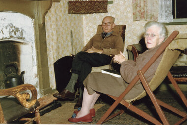 Halls Gap & Grampians Historical Society
Photograph - Coloured, C 1955-56
The couple are May & David Mitchell in the front room of their holiday shack called "The Holiday Hut" - built by E.C. Mitchell of Stawell at the site of the Borough Huts. See Rec 586 for more information.The photo shows a man and a woman seated opposite a fireplace. A black kettle is sitting in fire place and a piece of wood has been placed on a fire surround. The man is sitting on what appears to be a rocking chair and the woman is sitting on a deck chair. A shelf with a fringed cloth is situated in the corner to the left of the man's head. Both people are wearing glasses and the woman is wearing slippers."Dave and May inside holdiday hut.jpg=Imag" printed on rear of photobuildings, houses -
 Bendigo Historical Society Inc.
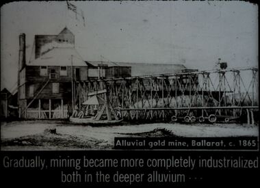
Slide - DIGGERS & MINING. DIGGERS AND MINERS, c1865
Diggers & Mining. Diggers and miners. Alluvial gold mine, Ballarat, c. 1865. Gradually, mining became more completely industrialized both in the deeper alluvium - - - Slide shows the building at the mine, with the raised rails to take the rock raised from in the mine to be crushed to allow the gold to be extracted. The mine's flag is flying. Markings: 28 994:LIF I. Used as a teaching aid.hanimounteducation, tertiary, goldfields -
 Surrey Hills Historical Society Collection
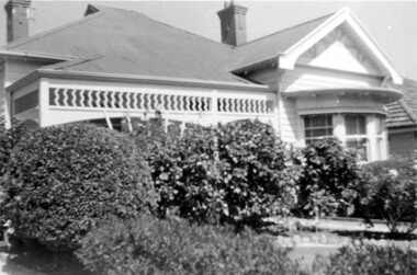
Photograph, 44 Guildford Road Surrey Hills, 1940, 1940
This was the home of the Offszanka family from 1913; they came to Surrey Hills from Richmond. Carl Theodore Offszanka (1874-1944) was a furrier. Both he and his wife Ida, nee Schade, (1882-1963) were born in Germany. They married in Victoria in 1908. Their home was called 'Westfalia' (ref: 1919 electoral roll), presumably after the region in NW Germany. They had at least 4 children: Carl Bernard - b 1909 Marie Eliese - b 1910 Erna Helena - b 1913; d 1996 - listed at Guildford Road in electoral rolls. Bernard George - b 1914; d 1987 (Surrey Hills) - listed at Guildford Road in electoral rolls. The family were associated with Our Holy Redeemer and also donated class photos of the school to the collection. Carl and Ida are buried in Box Hill Cemetery (RC 032-0034). The semi-circular bay window is not original to the house. This home has had a 2nd storey added to it in late 1990s. According to a family descendant (REF: Email 1/8/20 from grandson) Carl Theodor Offszanka purchased the home in 1913 for £616. He also purchased the adjoining vacant block of land at 42 Guildford Road and ran a large orchard on it before later selling it. This appears to have been between 1920-1930. The family continued to occupy the house until after 1980 when Erna Helena and Bernard George are listed in the electoral rolls. Our property register lists Erna Helena Offszanka as the last member there. She died on 5 May 1996. Members of the Offszanka family lived in this property from its beginnings for more than 70 years. Such longstanding tenancy is unusual.Black and white photo of a timber Edwardian home at 44 Guildford Road Surrey Hills. The home has 2 bricks chimneys, a corrugated iron roof, timber fretwork to the verandah and a semi-circular bay window. The facade of the house is partially obscured by mature garden, possibly including large camellias, with rock-edged garden beds and a central path. The front fence is not visible.edwardian style, guildford road, offszanka family, carl theodor offszanka, ida schade (miss), carl bernard offszanka, bernard george offszanka, westfalia, ida offszanka (mrs), erna helena offszanka (miss), marie eliese offszanka (miss) -
 Lakes Entrance Regional Historical Society (operating as Lakes Entrance History Centre & Museum)
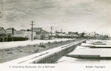
Postcard - Lakes Entrance, Bulmer H D, 1940c
Black and white postcard of Esplanade, showing timber sand groynes, rock wall, concrete footpath along the foreshore. Across the highway from left to right Kia-Ora House, Heyfield House, Coates Bros Garage, Robin Hood Inn, Vises Cafe, Methodist Church, Bellevue Guesthouse, Police Station, Maranui Guesthouse and Glenara Guesthouse. Lakes Entrance VictoriaLooking Along The Esplanade Lakes Entrancewaterfront, township, accommodation -
 Lakes Entrance Regional Historical Society (operating as Lakes Entrance History Centre & Museum)
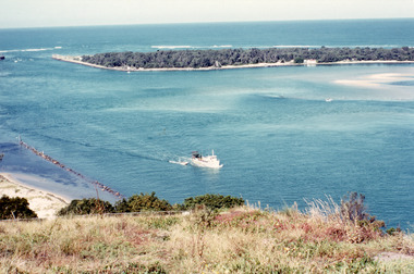
Photograph - The Entrance, Fraser, Ian, 1990c
Colour photograph of the lake. It shows a fishing boat with scallop dredge moving up the lake opposite the artificial entrance, grassy edge of Jemmy's Point in foreground above highway guard fence, rock groyne at entry to North Arm, sandy shallows at entry to Hopetoun Channel, scrub covered hummocks of south shore and Bass Strait in distance. Lakes Entrance Victoriaislands, waterways, topography -
 Melbourne Tram Museum
Document - Report, Norm Cross, "Notes on M&MTB Y and Y1 class tramcars", Nov. 1970
Report - typed - quarto sheet - two sheets, stapled titled "Notes on M&MTB Y and Y1 class tramcars" written by Norm Cross in November 1970. Looks at the history of Y469, and Y1's 610 to 613 including notes on the design, use, construction issues, depots, changes over the life and the use of 613 by the VR on the Sandringham to Black Rock line.trams, tramways, y class, y1 class, tram numbering, tramcar acquisition, tramcar design, tramcar construction -
 The Beechworth Burke Museum
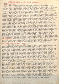
Geological specimen - Spotted Slate, Unknown
This specimen was recovered from Sedgwick, VIC. Spotted slate is a fine-grained porphyroblastic metamorphic rock with a number of compounds including muscovite, quartz, graphite with cordierite poikiloblasts and more. The cordierite poikiloblasts are rounded crystals that size up to 2.5 mm. the growth of these crystals is in response to metamorphism of low to medium intensity. The town Sedgwick was named after British geologist Adam Sedgwick This specimen is part of a larger collection of geological and mineral specimens collected from around Australia (and some parts of the world) and donated to the Burke Museum between 1868-1880. A large percentage of these specimens were collected in Victoria as part of the Geological Survey of Victoria that begun in 1852 (in response to the Gold Rush) to study and map the geology of Victoria. Collecting geological specimens was an important part of mapping and understanding the scientific makeup of the earth. Many of these specimens were sent to research and collecting organisations across Australia, including the Burke Museum, to educate and encourage further study.A solid rectangular hand-sized spotted slate specimen in a shade of light grey with darker flecks throughout Spotted Slate / Locality: Sedgwick Victoria | This is an early specimen / from the Quarter sheet / map. See sample 62 / page 18. Described as 'Spotted Slate' but these / days we would call it spotted hornfels / C. William 15/4/21 slate, spotted slate, victoria, beechworth, burke museum, geological specimen, mineralogy, sedgwick, sedgwick victoria, spotted slate specimen -
 Eltham District Historical Society Inc
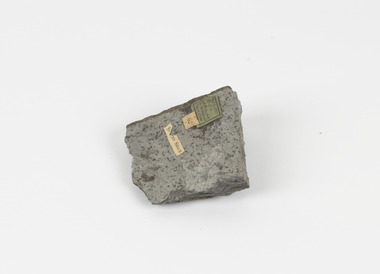
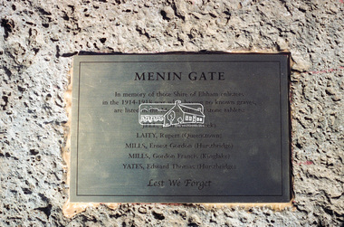
Negative - Photograph, Harry Gilham, Menin Gate Memorial Plaque and rock, Shire of Eltham Memorial Park, Kangaroo Ground, 1 Aug 2007
Memorial plaque created (2006) and mounted on a rock in memory of those Shire of Eltham enlistees in the 1914-1918 war who, having no known graves, are listed in the Menin Gate on stone tablets. John Jell (Steels Creek) Rupert Laity (Queenstown) Ernest Gordon Mills (Hurstbridge) Gordon Francis Mills (Kinglake) Edward Thomas Yates (Hurstbridge) Lest We Forgetedward thomas yates, ernest gordon mills, gordon francis mills, hurstbridge, john jell, kinglake, memorials, menin gate, queenstown, rupert laity, shire of eltham memorial park, steels creek, kangaroo ground -
 Eltham District Historical Society Inc
Negative - Photograph, Harry Gilham, Menin Gate Memorial Plaque and rock, Shire of Eltham Memorial Park, Kangaroo Ground, 1 Aug 2007
Memorial plaque created (2006) and mounted on a rock in memory of those Shire of Eltham enlistees in the 1914-1918 war who, having no known graves, are listed in the Menin Gate on stone tablets. John Jell (Steels Creek) Rupert Laity (Queenstown) Ernest Gordon Mills (Hurstbridge) Gordon Francis Mills (Kinglake) Edward Thomas Yates (Hurstbridge) Lest We Forgetedward thomas yates, ernest gordon mills, gordon francis mills, hurstbridge, john jell, kinglake, memorials, menin gate, queenstown, rupert laity, shire of eltham memorial park, steels creek, kangaroo ground -
 Lorne Historical Society
Functional object - Thunderbox, Circa 1930’s
The Great Ocean Road was built by World War 1 returned servicemen. Tolls were collected as sections of the road were completed. The first toll house was at Grassy Creek. It operated from 1922 to 1932 when it was moved to The Springs at Cathedral Rock about 5 km east of Lorne. The thunderbox is believed to have been used here at sometime between 1932 and 1936This is a rare archeological find. Items n this location are often damaged by the action of the sea and salt air. It is intimately associated with the early years of the development of the Great Ocean Road and the daily life of the workers. It is a typical example of the type of toilet used at the time. This reclaimed timber thunder box is enclosed on three sides. There is a circular hole on the top with a wooden handled lid attached by a chain. Inside is a steel can.great ocean road construction, returned sevicemen world war 1, great ocean road toll houses, toilet -
 Eltham District Historical Society Inc
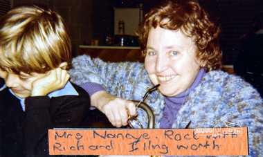
Photograph, Mrs Nancye Rock with Richard Illingworth, Eltham Christian School, 1981, 1981
Mrs Nancye Rock with Richard Illingworth, Eltham Christian School, 1981, when the school first operated out of the Eltham North Soccer clubrooms Photograph from one of several pages of a magnetic photo album relating to the staff, students and activities of the Eltham Christian School which operated as part of the Eltham Christian Church at Nyora Road, Eltham. See also entries for each photograph.eltham christian school, students, mrs nancye rock, richard illingworth -
 Robin Boyd Foundation
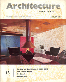
Journal, Architecture and Arts (2 copies), Aug-54
This features a photo and short CV of Robyn Boyd (p 15), followed by an Editorial 'The Life and Good Works of Robin Boyd' (pp 17-18). An article 'Some Buildings by Robin Boyd' (pp 19-37) features houses in Balwyn, Warrandyte, Black Rock, Camberwell (Boyd House I), Templestowe, Red Hill, Canberra, and shops in Jordanville, West Heidelberg and North Balwyn.architecture, art, walsh st library -
 Stawell Historical Society Inc
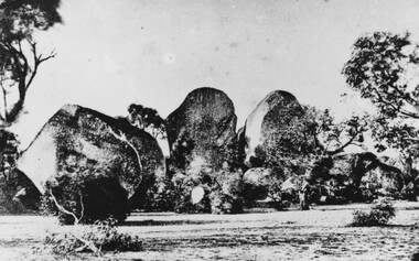
Photograph, Sister Rocks looking North c1860's
Sister Rocks. Looking North c1860's. This photo is of a well known land mark along the Western Highway. They take their name from 3 sisters named Levy, who camped there with their parents during the early days of Stawell. In 2011 photos were taken to update and add to our "Sister Rock" collection. Direction of photos has been identified and are catalogued as on the updated index card. Black & White print of a photograph depicting large granite boulders with trees in foreground. c1900Looking North from Western Highwaystawell scenery -
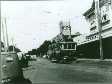 Melbourne Tram Museum
Photograph - VR Sandringham tram in Bay Road, late 1940s, late 1940s
Photo shows either VR tram 48 or 49 (two man car) in Bay St Sandringham, just prior to turn into the tram depot. In the background is the Roxy Theatre and the spire of the All Souls Anglican Church. (The church spire has since been rebuilt). The VR Sandringham to Black Rock tramway closed on 5-11-1956. The print is a copy print of an original photograph.Shows a VR tram in Bay Road Sandringham.Black and white copy print on Kodak paper of a VR Sandringham tram in Bay Road. trams, tramways, vr trams, bay road, sandringam -
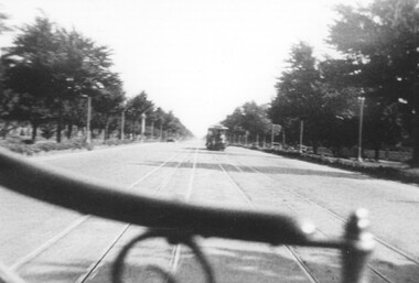 Melbourne Tram Museum
Photograph, St Kilda Road from a cable tram, c1910
The photograph shows the view from the front seat of a cable tram travelling along St Kilda Road with another cable tram on the other track. The photo shows, though out of focus, the median strip trees, street lights and the rock kerb markers known as "dragon teeth". The line was converted to electric traction in 1925/26. See also item 5894 for another image.Yields information about St Kilda Road, possibly in the 1910s.Photograph, black and white, plain papertrams, tramways, cable tram, st kilda road, grip car -
 Phillip Island and District Historical Society Inc.
Photograph, 1960's
Donated by N.M. & J.D. Archibald, 1973 April.Black & White Photograph. Chicory Kiln. Kingston Gardens. Mr. V. Johnston. Built for Mr. de la Haye. Very early bricks. Thought to be from McHaffie Homestead and later from Innishowen. These bricks could have been originally from Corinella Settlement. Walls also show pieces of local rock, iron piping, bedsteads etc. Chicory Kiln Album.local history, photography, photographs, agriculture buildings, historic, chicory kiln, chicory industry, kingston gardens, v johnston, n & j archibald -
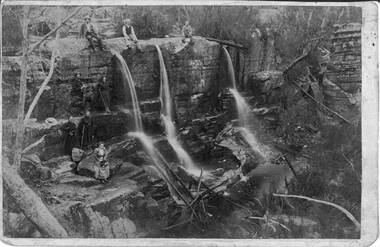 Halls Gap & Grampians Historical Society
Photograph - Sepia, C 1900s
Some of the people in the photo are said to be members of the Balmain family. James and his wife Amy Sophia (nee D' Alton) had three children. Amy died suddenly in 1902 at the age of 37. See p45 Bridging the Gap.Photo shows group of people seated and standing by a waterfall,three men seated on top of waterfall, next level a man and a young woman ( who is holding a hiking stick), top level a man and woman both holding hiking sticks. In front of them seated on a rock is a woman holding a hat. on her lap Waterfall is split into three and they flow over a larger rocky platform.Balmains c1900recreation, bush-walking -
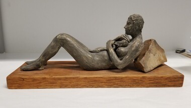 Royal Australian and New Zealand College of Obstetricians & Gynaecologists (RANZCOG)
Decorative object - Statue of a mother reclining with a newborn bavy, Victoria Chancellor (nee Simcock)
This sculpture was a commissioned artwork made by Victora Chancellor (nee Simcock), a Sydney artist.Ceramic sculpture, depicting a reclining mother holder her newborn baby. The mother is lying on her back, with knees drawn up and feel flat on the ground, protectively cradling a newborn baby on her chest. The umbilical cord between baby and mother is still attached. The mothers upper back is resting against a rock, holding her partially upright. Sculpture is mounted on a rectangular wooden base.obstetric delivery