Showing 112771 items
matching tracks/roads
-
 Hawthorn Historical Society
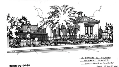
Drawing - Property Illustration, 26 Barkers Road, Hawthorn
'After training as a Cartographic Draftsman within the mining industry, I worked as a property illustrator for real estate firms in the eastern suburbs of Melbourne for 23 years from 1983. I initially photographed houses with a Polaroid camera and made a 'thumbnail' sketch while there. The photos were used to scale off a sketch in pencil and then that sketch was overlaid with drafting film and the 'pen and ink' completed. The pens I used were the Rotring ‘Rapidigraph’ drafting pens. The ink was also made by Rotring (German).The film was ‘Rapidraw’, polyester drafting film, double matte. It takes a very fine line and doesn’t bleed. As well as house sketches, there were often floor plans and site plans ordered. Aerial sketches were ordered when the property needed an overall view.' (Margaret Picken, 2020)This property illustration is one of a series created by Margaret Picken for a range of real estate agents in Melbourne between c. 1983 and c. 2006. Each work is signed and dated by the artist.Gift of Margaret Picken, 2020Pen and ink property illustration on drafting film of 26 Barkers Road, Hawthorn by Margaret Picken.26 Barkers Road, Hawthorn, Margaret Picken '90. Woodards - Hawthorn, rear 35 Elm T, Hawartist - margaret picken 1950- -
 Ballarat Tramway Museum
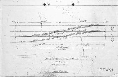
Drawing - Brisbane City Council Tramway Trackwork drawings
Prepared by the City of Brisbane for the design of trackworkYields information on the design of trackwork.Set of nine City of Brisbane Tram Track drawings .1 - PPW91 - Standard Crossover left hand - 4'6" between tracks .2 - PPW2450 - Data for British Standard Crossings .3 - PPW 241 - Data for British Standard Lateral Switches .4 - PPW 463 - Concrete Track Construction is 102.73lb rail. .5 - PPW 501 - ditto for AS 82lb rail and other rails .6 - Not numbered - Concrete roads when using T rail sleepers .7 - PPW 575 - 150' radius RH crossover - 5' between tracks .8 - PPW 576 - 150' radius RH Crossover - 4'6" between tracks .9 - PPW 577 - 150' radius LH Crossover - 5' between tracks - 14/12/1948trackwork, points, switches, bcc transport, tramways -
 Glen Eira Historical Society
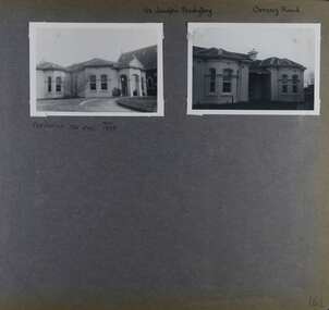
Album - Album page, St Joseph's Presbytery, Orrong Road, Circa 1972
This photograph is part of the Caulfield Historical Album 1972. This album was created in approximately 1972 as part of a project by the Caulfield Historical Society to assist in identifying buildings worthy of preservation. The album is related to a Survey the Caulfield Historical Society developed in collaboration with the National Trust of Australia (Victoria) and Caulfield City Council to identify historic buildings within the City of Caulfield that warranted the protection of a National Trust Classification. Principal photographer thought to be Trevor Hart, member of Caulfield Historical Society. Most photographs were taken between 1966-1972 with a small number of photographs being older and from unknown sources. All photographs are black and white except where stated, with 386 photographs over 198 pages. St Joseph's buildings and grounds are contributory properties to HO72 Elsternwick Estate and environs - City of Glen Eira.Page 162 - two photographs of St Joseph's Presbytery, Orrong Road.Handwritten: St Joseph's Presbytery Orrong Road [top right] / PREVIOUSLY "THE EMS" 1908 [under left photo] / 162 [bottom right]trevor hart, orrong road, curved windows, decorative brackets, arched windows, bay window, portico, slate roof, st joseph's presbytery, catholic church, st joseph's church, st joseph's primary school, porte cochere, the ems, elsternwick, rendered walls, clergy residences, drives, late victorian style, house names -
 Glenelg Shire Council Cultural Collection
Photograph - Photograph - Blacknose Quarry Access Road, 29/09/1952
Port of Portland Authority ArchivesFront: 'Blacknose Quarry Access Road 25-9-52 Looking South' printed bottom fram Back: purple PHT stamp -
 Halls Gap & Grampians Historical Society
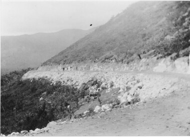
Photograph - B/W, C 1927
... Roads ...New road approaching Wirranatwa GapRoad through Mirranatwa Gap with people walking???access routes, mirranatwa gap, roads -
 Victorian Aboriginal Corporation for Languages
Audio CD, Music recorded at Gerard Mission, Cummeragunja, Barmah and Deniliquin, 1963
Songs performed by Annie Mason, Cyril Gerard and Cyril Lindsay at Gerard Mission; Sophie and Coral Briggs at Cummeragunja; Aaron Briggs at Barmah; Ralph Day and Dennis Atkinson at Deniliquin.CD, recording notes (for tracks 00191a and 00191b)gerard mission, cummeragunja, barmah, deniliquin, annie mason, cyril gerard, cyril lindsay, sophie briggs, coral briggs, aaron briggs, ralph day, dennis atkinson -
 Victorian Aboriginal Corporation for Languages
Audio CD, Songs performed by Charlie Kirby and interview with Mrs Jackson Stuart, 1962
Charlie Kirby sings songs at Balranald. Life interview and stories with Mrs Jackson Stuart at Swan Hill.CD, recording notes (for tracks 00191a and 00191b)yitha yitha, yida yida, wemba wemba, wamba wamba, balranald, swan hill, charlie kirby, mrs jackson stuart -
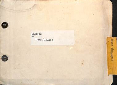 Ballarat Tramway Museum
Administrative record - Report, State Electricity Commission of Victoria (SECV), "Legend - Track gauges", 1954/55
Record shows the condition of the rail head at many points throughout the Ballarat system. Gives the type of rail, its weight, gauge, location and date of measurement See item 9127 for a report on the Special Work. Some sections measured in May 1954, rest May 1955Demonstrates a detailed report into the condition and wear of the Ballarat Tramways trackwork in 1954/1955.Report - within a manila card folder with steel clips containing about 44 drawings on drawing paper of rail sections.Outside cover in ink "Legend Track Gauges"ballarat, secv, trackwork, rails, reports -
 City of Kingston
Pamphlet - Colour, Fergusson & Mitchell Lith, Sandringham Rises, c. 1888
Sales plan for land in the suburb of Sandringham, bounded by Bluff Road, Bay Road and William Street, and incorporating Frances Street.The developing urban area of Highett (then called Sandringham) within the City of Kingston. This land sale pamphlet illustrates the subdivision of land within the municipality and the changing demographic of the district as new houses are constructed close to infrastructure.Colour pamphlet advertising for sale 35 lots in Sandringham Rises, Sandringham. Incorporates a map of the estate bordered by Bluff Road, Bay Road and William Street, including Frances Street.Handwritten in grey pencil next to the words 'THREE O'CLOCK': 1888 Handwritten in blue ben next to the words '& BUSINESS SITES': 1888land sales, sandringham, highett -
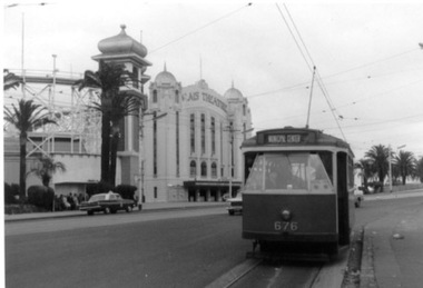 Ballarat Tramway Museum
Photograph - Black & White Photograph/s, 31/10/1965 12:00:00 AM
Set of three Black and white photographs on Kodak paper of an Association of Railway Enthusiasts tram tour with X2 676. The tour featured the use of a Washington DC destination roll. Date of Tour 31/10/1965. 1422.1 - X2 at the terminus of route 69/79 routes at the Esplanade, St Kilda. Note the track is alongside the north side kerb. Has Palais Theatre in the background and Luna Park. Tram showing destination of "Municipal Center" 1422.2 - Hawthorn Road, just north of Balaclava road, looking south. SW6 869 alongside. 676 on temporary track - during the reconstruction of Hawthorn Road - permanent track has been completed alongside. Tram showing destination of "Racecourse" 1422.3 - X2 676 on "Bang Road" Coldblo Road at Malvern depot entry looking east. Tram showing destination of "Friendship Hts". See P.Winspur notes, data sheet for Reg. Item 1418 and Dave Macartneytrams, tramways, tram tours, are, trackwork, mmtb, tram 676, tram 869 -
Kew Historical Society Inc
Archive (series) - Subject File, Barkers Road, 1953
Various PartiesReference, Research, InformationKHS OrderSubject file with multiple items of research relating to the history of Barkers Road, previously Barkers Track (sic) including: 2 copies of ‘Barkers Track: Recollections of the Hawthorn Kew Boundary’ (Typescript, Mervyn Chinner, undated, 4pp), ‘The Boroondara Family Hotel’ (Photocopied typescript, 1987, 10pp), ‘Barkers Road (Gwen McWilliam, 1976), a photocopy of an ADB entry on BARKER, Edward (1816-1885). The file also includes a typed letter to Mrs Dickins from Cr WHS Dickinson (1953) relating to the state of Barkers Road and sundry newspaper clippings/articles.barkers road - kew (vic.), barkers track - kew - hawthornbarkers road - kew (vic.), barkers track - kew - hawthorn -
 Whitehorse Historical Society Inc.
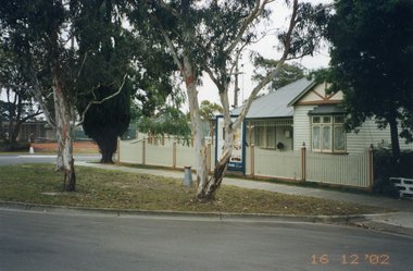
Photograph, Whitehorse Road, Mitcham No.427
427 Whitehorse Road, Mitcham was owned by the Copp family in the 1950s.|See also NP2519-2520 and NP2560, NP3245Coloured photograph of renovated old house at 427 Whitehorse Road, Mitcham, taken in 2002 from Whitehorse Roadwhitehorse road, mitcham no.427 -
 Whitehorse Historical Society Inc.
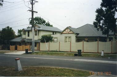
Photograph, Whitehorse Road, Mitcham No.427
427 Whitehorse Road, Mitcham, was owned by the Copp family in the 1950s|See also NP2519-2520 and NP2560, NP3244Coloured photograph of renovated old house at 427 Whitehorse Road, Mitcham, taken in 2002 from Dunlaven Roadwhitehorse road, mitcham no.427 -
 Melton City Libraries
Photograph, West Melton-Coburns Road, 1969
Coburns Road - 19th c family descendents living in Melton. Coburn Primary School Cr George Coburn. 1930’s. December 1935 Shire President Cr Geo Coburn convened meeting to form the Bush Fire Brigade. Road construction of Service road and beginnings of West Melton subdivision. West Melton-Early Division View of Coburns Road. council, local significant events -
 Kiewa Valley Historical Society
Black and White photograph of Road Making Machinery, Kiewa Road Making 25/08/1938 No. 2, 25/08/1938
Construction of the main road from South Tawonga to the Bogong High Plains, to provide access to the construction sites for the new Kiewa Hydro Electric Scheme, was commenced early in 1938, the work being undertaken on behalf of the commission by the Country Roads Board. For the construction work, the Commission purchased three Caterpillar - model R07 - diesel crawler tractors equipped with Kay Brunerei (Brunner) hydraulically operated trailbuilders (angle dozers). This acquisition resulted from a visit to the United States of America in May, 1937 by the Construction Engineer ( Mr. C.H. Kernot) and Assistant Civil Engineer ( Mr. J.F. Douglas) where they saw this relatively new type of equipment in use. With the co-operation of the CRB, the Commission demonstrated the operation of these machines at Fishermen's Bend on 6th April, 1938. They were then sent to Kiewa where they commenced operation towards the end of the month. From South Tawonga, the route let immediately across the Western Branch of the Kiewa River necessitating the construction of a bridge 100 feet long. By the end of 1939, the excavation had been 'opened up' for a distance of 19 1/2 miles (approx. 31 km.) and of this length, 10 miles (approx. 16 km.) had been surfaced. (see KVHS 0328)The purchase of this type of mechanical equipment in road making was a huge investment, as prior to this most of the work would have been done manually with the use of picks and shovels. Not only were many months of hard manual labour saved, but a very significant amount of time in providing access to the proposed work sites for the new Kiewa Hydro Scheme. This photo is an excellent reminder of how primitive the early machinery was compared to the present but also represents the forward thinking of the State Electricity Commissions engineers in purchasing such innovative equipment.A black and white photograph of road making near Mt. Beauty in 1938. Mount Beauty hills can be seen in the background with cleared land for grazing in the fore ground.Hand printed in black ink at the top of the photograph is 'Kiewa Road Making 25/8/1938'. On the right hand corner has been printed the number 2. It has been printed on gloss Velox paper.road making, state electricity commission, caterpillar tractor, kiewa, secv -
 Kew Historical Society Inc
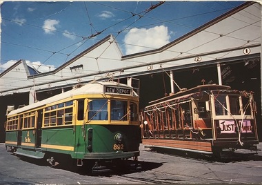
Postcard, Biscay Greetings Pty Ltd, Trams at Kew Depot, c.1991
The Kew tram depot is located on the corner of Barkers Road and High Street, Kew. It is one of eight tram depots on the Melbourne tram network. The depot opened on 8 May 1915. The main yard has 12 covered roads. There are two tracks for trams leaving or entering via Barkers Road, and a single track connecting to High Street.Postcard produced c.1991 to commemorate 75 Years of Service of The Kew Depot (1915/16-1991). The postcard shows two trams at the depot. The details are included in the information provided on the reverse.Kew Depot is ready for work W Class 892 waits for its next duty while visiting V Class 214 is ready for special work Photo by R. J. Marsh T101 Copyright Biscay Greetings Pty Ltd Telephone (03) 562 3599tramways - kew, kew tramways depot, -
 Robin Boyd Foundation
Slide, Robin Boyd, 1965
Colour slide in a mount. BP House (1964), St Kilda Road, Melbourne, Australia. (Architect: Anthony B Armstrong.)Made in Australia / 5 / JAN 65M / B-P St Kilda Road 1964 (Handwritten)melbourne, robin boyd, slide -
 Robin Boyd Foundation
Slide, Robin Boyd, 1965
Colour slide in a mount. BP House (1964), St Kilda Road, Melbourne, Australia. (Architect: Anthony B Armstrong.)Made in Australia / 9 / JAN 65M / B-P St Kilda Road 1964 (Handwritten)melbourne, robin boyd, slide -
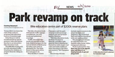 Greensborough Historical Society
Article - Newspaper Clipping, Courtney Beaumont, Park revamp on track, 04/03/2020
Article on the proposed development of a bike education track at Delta Road ReserveNewspaper clipping, black text with colour imagedelta road reserve, bike education, parks and reserves -
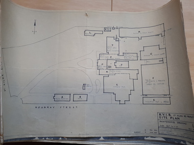 Vision Australia
Plan - Image, RVIB Maintenance drawing, April 1963 - November 1966
A series of maintenance drawings were made or copied by an architectural firm. These plans include: 1 - St Kilda Road Property - a site map of the buildings and grounds with the names of the various areas added. 2 - St Kilda Road Central Building (copied from a RAAF drawing) showing rooms on the ground floor. 3 - St Kilda Road Central Building (copied from a RAAF drawing) showing rooms on the first floor. 4 - St Kilda Road Central Building roof plan. 5 - St Kilda Road Factories showing the layout on the ground floor. 6 - St Kilda Road Factories showing the layout on the first floor. 7 - St Kilda Road building showing all three floors of the building rented out to Alfred Hospital. 8 - St Kilda Road caretaker, factory, fundraising and rehabilitation training buildings. 9 - Raleigh Street, Prahran hostel layout for both girls and boys.9 pages of plans of buildings on St Kilda road siteVarious - see individual plansmyer house, royal victorian institute for the blind, plans, raleigh street hostel, alfred hospital -
 City of Moorabbin Historical Society (Operating the Box Cottage Museum)
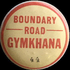
Badge - Boundary Road - Gymkhana, ca. 1929
The Murrumbeena Branch of the Alfred Hospital Auxiliary held a grand charity gymkhana on 7 September, 1929 at the Central Speedway, Boundary Road, Bentleigh. It was a full racing program with several trotting events. There were also games and several well-stocked stalls. Early settler market gardeners were generous with their support for local hospitals and charitable associationsMetal Pin Boundary Road - GYMKHANA - 44alfred hospital auxillary, murrumbeena, boundary road, bentleigh, central speedway, pioneers, moorabbin -
 Eltham District Historical Society Inc
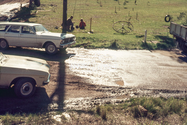
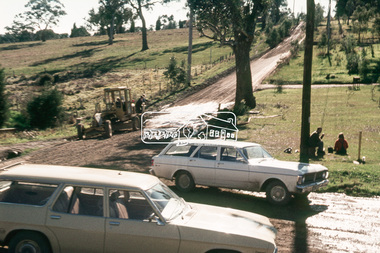
Slide, Southern alignment of Montpelier Drive looking north up Bonds Road, Lower Plenty, 18 July 1972, 1972
Water drainage work undertaken by Eltham Shire Council in Bonds Road, Lower Plenty outside the Martin property opposite Montpelier Drive, July 1972 The water is not able to enter the pit on the northern side of Montpelier. It then flows along and across Bonds Road.35 mm colour positive transparency Mount - Agfacolor Service (Blue)Bonds Road (Martin property) 12.10 pm 18.7.72bonds road, drainage works, eltham shire council, infrastructure, lower plenty, martin property, montpelier drive -
 Eltham District Historical Society Inc
Slide, Southern alignment of Montpelier Drive looking north up Bonds Road, Lower Plenty, 18 July 1972, 1972
Water drainage work undertaken by Eltham Shire Council in Bonds Road, Lower Plenty outside the Martin property opposite Montpelier Drive, July 1972 The water is not able to enter the pit on the northern side of Montpelier. It then flows along and across Bonds Road.35 mm colour positive transparency Mount - Agfacolor Service (Blue)Bonds Road (Martin property) 12.10 pm 18.7.72bonds road, drainage works, eltham shire council, infrastructure, lower plenty, martin property, montpelier drive -
 Wodonga & District Historical Society Inc
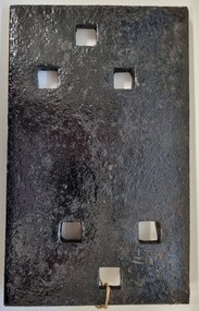
Functional object - Rail fish plate from Cudgewa Line, 1930 - 1960s
Cudgewa Line -The Cudgewa railway line opened in stages between 1889 and 1921. The first section from Wodonga to Huon opened on 10 September 1889. It was extended to Bolga on 18 July 1890, Tallangatta on 24 July 1891, Shelley on 13 June 1916 (the highest station in Victoria), Beetomba on 10 April 1919 and Cudgewa on 5 May 1921. The line had 1 in 30 grades and trestle bridges that have been heritage listed. In 1919, the line was used to carry materials for the construction of Hume Weir, and three years later a spur line connecting Ebden to the weir was opened. In the 1960s, Cudgewa became the railhead of materials for the Snowy Mountains Scheme. The last passenger service from Wodonga to Tallangatta ran on 30 September 1961. The turntable and passenger platform at Cudgewa were abolished in 1976. This fish plate came from the rails of the Cudgewa Line at Gordon Roy's hut which was situated behind Perry's Stump Hotel outside Wodonga. The hut was used as an office with the points lever outside to switch trucks to different tracks on the Bandiana and Cudgewa lines.This item is significant as it was part of the railway line to Cudgewa which played an important role in North east Victoria carrying freight during the construction of the Hume Weir and the Snowy Mountains Scheme.A section of flat plate. These plates were used in pairs to connect the ends of adjacent rails in railway track. victorian railways, cudgewa rail line, railway components -
 Whitehorse Historical Society Inc.
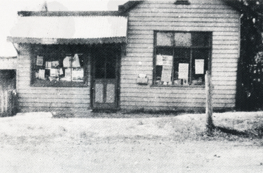
Photograph, Forest Hill Post Office
The first Post Mistress and Storekeeper was Catherine Peacock. The Building was located at259 Canterbury Road and was demolished in1950. The next Forest Hill Post Office was situated on the North West Corner of Canterbury and Springvale road.Copy of a Black & White photo of the Forest Hill Post Office, near the intersection of Springvale Road, c1926. and Canterbury road. In the 2000s it was the site of Swan Hardware.post offices, forest hill post office -
 Melbourne Tram Museum
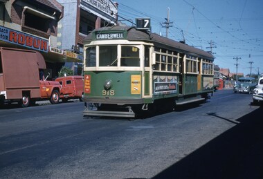
Slide, John Webster, 5/04/1960 12:00:00 AM
Colour slide, Kodak, white cardboard of tram SW6 918, in Burke Road, Gardiner after turning from Malvern Road, route 7, Camberwell. In the background are the shops since removed advertising Robur tea and the Herald and the Australasian Post. Slide dated 5-4-60.Hand writing on rear in ink "5-4-60 tram 918 Burke Road Gardiner Victoria"trams, tramways, sw6 class, camberwell, burke rd, route 7, gardiner, tram 918 -
Whitehorse Historical Society Inc.
Document, Mitcham Shopping Centre redevelopment, 1960s-1970s
Collection of papers relating to the Mitcham Chamber of Commerce proposal for redevelopment of Mitcham Shopping Centre.Collection of papers relating to the Mitcham Chamber of Commerce proposal for redevelopment of Mitcham Shopping Centre, in particular, parking, and reconstruction of Whitehorse Road by the Country Roads Board. Incl. correspondence, plans, news cuttings.Collection of papers relating to the Mitcham Chamber of Commerce proposal for redevelopment of Mitcham Shopping Centre.mitcham shopping centre, whitehorse road, mitcham, mitcham chamber of commerce, armstrong, raleigh edward, car parks, victoria. country roads board -
 Surrey Hills Historical Society Collection
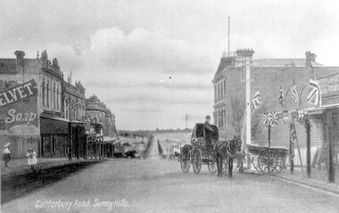
Work on paper - Photograph, Canterbury Road, near the corner of Union Road, 1911
J A Geer's grocery store operated from 1909-1912 on the site established by George Sim in 1884. He bought a house and added a shop where, in 1889, he established the first post office in the area. Prior to this residents had to go the Box Hill to collect mail. Date is approximate.This records one of the earliest businesses in Surrey Hills. To begin with, businesses developed along Canterbury Road rather than Union Road, in part because of the muddy nature of the land north of the railway line.Black and white photo taken from a postcard of Canterbury Road, near the corner of Union Road, looking west in 1906 or 1907. Two children play on the LHS of the street and there is a man on a horse and carriage, and a cart, on the RHS. Buildings on the RHS are the Surrey Family Hotel and J A Geer's grocery store; on the LHS is a row of double-storey terraces including Hansen's Terrace on Canterbury Road to the west of Union Road.On LHS within the original image is 'Canterbury Road, Surrey Hills'; on the rear in top LH corner in blue biro in Jocelyn Hall's handwriting "J H / spare"canterbury road, geer's grocery store, surrey family hotel, businesses, horse drawn vehicle, hansen's terrace, post card, mr j a geer -
 Glen Eira Historical Society
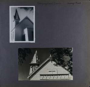
Album - Album page, Congregational Church, Grange Road, Circa 1972
This photograph is part of the Caulfield Historical Album 1972. This album was created in approximately 1972 as part of a project by the Caulfield Historical Society to assist in identifying buildings worthy of preservation. The album is related to a Survey the Caulfield Historical Society developed in collaboration with the National Trust of Australia (Victoria) and Caulfield City Council to identify historic buildings within the City of Caulfield that warranted the protection of a National Trust Classification. Principal photographer thought to be Trevor Hart, member of Caulfield Historical Society. Most photographs were taken between 1966-1972 with a small number of photographs being older and from unknown sources. All photographs are black and white except where stated, with 386 photographs over 198 pages. This church has since become the Greek Orthodox Church. From Victorian Heritage Database: Citation for Greek Orthodox Church HO84 https://vhd.heritagecouncil.vic.gov.au/places/43587 (as at 19/10/2020) The former Primitive Methodist, later Congregational, church at 152 Grange Road, Glenhuntly, is a small timber building, erected in 1885 (89?) in South Melbourne and relocated to Glenhuntly in 1909. It is a highly individual picturesque timber structure with distinctive spire and timber enrichment. It has aesthetic, historical and social significance. Its aesthetic value is derived from the choice of materials and picturesque Gothic Revival character showing American influence. Its historical value is derived from its survival as a rare example of a Primitive Methodist Church building whilst its social value hinges on its early roles as a place of worship for the Primitive Methodists in South Melbourne and the Congregationalists in Glenhuntly.Page 72 of Photograph Album with two photographs (one portrait and one landscape) of the upper exterior and tower of the Congregational Church on Grange RoadHand written: Congregational Church, Grange Road [top right] / 72 [bottom right] trevor hart, congregational church, grange road, gothic revival, carnegie, glen huntly, glenhuntly, greek orthodox church, primitive methodist church, spire, timber buildings -
Whitehorse Historical Society Inc.
Newspaper - Articles, Central Road, Nunawading, 1953
Collection of Age and Reporter articles re native gums and wattlesCollection of Age and Reporter articles re native gums and wattles which were felled in Central Road, Nunawading for road widening which led to protests from angry residents.Collection of Age and Reporter articles re native gums and wattlescentral road., nunawading, roads and streets, native plants, moore, herbert, field, jean, uhl, wylie, alan