Showing 1831 items
matching walks
-
 Ballarat Heritage Services
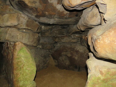
Photograph - Colour, Avebury World Heritage Site, Prehistoric Monuments, England, 2016
Colour photograph of the Silbury Hill, an immense Neolithic man-made mound part of the Avebury World Heritage Site. The Avebury World Heritage Site is a complex of outstanding prehistoric monuments comprising Windmill Hill (Early Neolithic enclosure and Bronze Age burial mounds); Silbury Hill; West Kennet Long Barrow; Avebury Stone Circles and West Kennet Avenue; The Sanctuary (site of stone and timber circles). It is part of National Trust and English Heritage. Visitors may walk to sites.Colour photograph of Avebury World Heritage Site.avebury world heritage site, rocks, prehistoric monuments -
 Ballarat Heritage Services
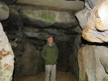
Photograph - Colour, Wayne Phillipson, Avebury World Heritage Site, Prehistoric Monuments, England, 2016
Colour photograph of the Silbury Hill, an immense Neolithic man-made mound part of the Avebury World Heritage Site. The Avebury World Heritage Site is a complex of outstanding prehistoric monuments comprising Windmill Hill (Early Neolithic enclosure and Bronze Age burial mounds); Silbury Hill; West Kennet Long Barrow; Avebury Stone Circles and West Kennet Avenue; The Sanctuary (site of stone and timber circles). It is part of National Trust and English Heritage. Visitors may walk to sites.Colour photograph of the Avebury World Heritage Site.prehistoric monuments, avebury world heritage site, rocks -
 Ballarat Heritage Services
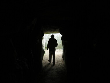
Photograph - Colour, Wayne Phillipson, Avebury World Heritage Site, Prehistoric Monuments, England, 2016
Colour photograph of the Silbury Hill, an immense Neolithic man-made mound part of the Avebury World Heritage Site. The Avebury World Heritage Site is a complex of outstanding prehistoric monuments comprising Windmill Hill (Early Neolithic enclosure and Bronze Age burial mounds); Silbury Hill; West Kennet Long Barrow; Avebury Stone Circles and West Kennet Avenue; The Sanctuary (site of stone and timber circles). It is part of National Trust and English Heritage. Visitors may walk to sites.Colour photograph of Avebury World Heritage Site. avebury world heritage site, prehistoric monuments, rocks -
 Federation University Art Collection
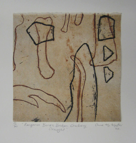
Printmaking - etching, 'Kangaroo Bones, Broken Crockery, Drought' by Anne McMaster, 2008
Anne McMaster (1959- ) Born Melbourne Artists' Statement: In the thick of drought kangaroos perish and farmers walk off the land. All that is left are bones and broken crockery. Overlaid images prompt the observer to question the Anglo-Saxon relationship to country, to that of indigenous tribes. Foul biting and earthy colours bring attention to the weathered landscape of Australia. This item is part of the Federation University Art Collection. The Art Collection features over 2000 works and was listed as a 'Ballarat Treasure' in 2007.Framed limited edition print.art, artwork, anne mcmaster, print council of australia, kangaroo, bones -
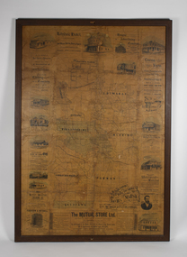 Bacchus Marsh & District Historical Society
Map, The Unique Advertising Combine, The Unique Combine's New Map of the Shire of Bacchus Marsh, 1890
This map was one of a number of similar maps produced for advertising purposes by a company called, 'The Unique Advertising Combine'. The company was located in Melbourne on Queens Walk. A brief item in the Bacchus Marsh Express newspaper on 29 March 1890 , page 2, indicated that subscribers to the Bacchus Marsh Express could obtain a copy of this map in the next issue of that newspaper. On the map is the detail that it was compiled by W.H. Bonney from official records supplied by D. A. Little, hire Secretary, (of Bacchus Marsh Shire).This map with its accompanying illustrations of local businesses and shops in Bacchus Marsh is an important documentary and visual snapshot of the town and district of Bacchus Marsh in the later part of the nineteenth century. The illustrations for some of the local businesses are the only known visual record of those particular buildings. The map is a rare surviving example of the material produced by The Unique Advertising Combine. Another similar example for the Shire of Mornington is held by the State Library of Victoria,A map of the Shire of Bacchus Marsh produced in March 1890. The map is mounted on a board and enclosed within a timber frame. The map includes an inset detail section showing the central part of the township of Bacchus Marsh including the main shopping and business streets. Land holdings with the first European land holders names indicated are included on the map. Rivers, creeks, major roads and the railway line are also shown on the map. Around the edges of the map are illustrated advertisements mostly for Bacchus Marsh businesses but which also includes some businesses located in Melbourne. maps bacchus marsh shire, shops bacchus marsh -
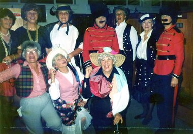 Heidelberg Golf Club
Photograph, Faye Lamb, Heidelberg Golf Club: Ladies' Christmas celebrations1990s: Lambeth Walk, 1992
Heidelberg Golf Club: Ladies' Christmas celebrations 1990s: Lambeth Walk. Photo 1: Margo Wilson, Elaine Morrison, Jo Kopp, Elizabeth Scanlon, Estelle Moran, Es Crampton, Faye Lamb, Roma Read, Liz Sanders, Gwyn Jones. Photo 2: Liz Sanders, Es Crampton, Gwyn Jones and Faye Lamb. Photo 3: Roma Read. Photo 4: Roma Read and Liz Sanders. Photo 5: Faye Lamb and Liz Sanders.5 Colour photographs and captionsladies' golf, hgc women's golf, ladies' christmas dinner -
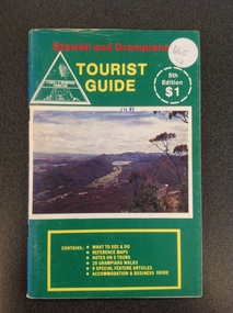 Stawell Historical Society Inc
Book, Stawell & Grampians Tourist Council, Stawell & Grampians Visitor Guide & Directory 1981, 1981
Tourist Guide to Stawell and The GrampiansGreen paper cover with Red, Yellow & White Print. Centre of page is a colour photo of the Grampians. Red Test. "Stawell and Grampians" inside white triangle "Stawell & Grampians Promotion". Yellow Print Tourist Guide" Inside a white segmented circle, white Print "5th Editon $1" Inside Yellow outlined rectangle with yellow Print. "Contains: WHAT TO SEE & DO REFERENCE MAPS NOTES ON 5 TOURS 28 GRAMPIANS WALKS 9 SPECIAL FEATURE ATICLES ACOMMODATION & BUSINESS GUIDEstawell tourism -
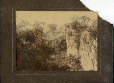 Orbost & District Historical Society
coloured photograph
There is no information with this item. "The Pyramids", was named due to huge rocks that jut out from the hill, being shaped similarly to the Egyptian Pyramids. " Where the Murrindal River winds between high limestone bluffs before disappearing into a mountainside and becoming an underground river, four miles north-east of Buchan, is the region known as The Pyramids. It is an area of limestone caverns and sink holes overshadowed by three rock stacks. Some of the caves are the last resting places of long dead Murrindal animals." ( from MBW Walk magazine 1970 - Melbourne Bushwalkers"A hand-painted colour photograph of a view of mountain ranges with men on horses in the background.on front - "Pyramid Gorge Buchan"pyramid-gorge-buchan murrindal limestone-caves -
 Kiewa Valley Historical Society
Photo - Cleve Cole
This photo depicts the rescue of three local skiets that became trapped on Mt Bogong during a blizzard and became known as the Cleve Cole tragedy . Mick Hull Howard Michell and Cleve Cole where skiing on Mt Bogong and could not find their way off the mountain via Staircase Spur due to Blizzard conditions and ended up in the Mitta Valley. Howard Michell walked to the Battys farm to get help for his weak and injured friends. Cleve Cole died shortly after arriving at Omeo hospital. This photo is historically significant as it tells the rescue story of this tragedy. The photos are of the people involved which add to the story. Mt Bogong Victoria's highest mountain is accessed from the Kiewa Valley and near by high plains and over shadows Mt Beauty township therefore is a local story. The photo comes from the rescue party which is a rare photo and thus has great interpretive capacity . The skiing history is one of KVHS main themes and this photo is part of our Skiing Across Country exhibitionBlack and white photo of several men in the bush near Mt Bogong. Photo is glued on to cardboard with a dark grey border and light grey wider border on the outside.Handwritten on back "The Discovery of Cleve Cole / up the Big River (Below Paddy's Flat) / Cole is arrowed / Cyril Rootsey / Jack Batty / Bill Batty / Paul? Bitner / Tom Fitzgerald / Etc. / (I think dad is the one with his hand up to his face)" Back - red stamp - "Herald Feature / Service / Melbournecleve cole. mt bogong. big river. paddy's flat. -
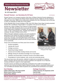 Eltham District Historical Society Inc
Newsletter, Newsletter, No. 247 August 2019
Contents: • Russell Yeoman – our Secretary for 50 Years by Jim Connor • Our Next Meeting – Wednesday 14th August 2019 • September Excursion – Culla Hill Walk • The Value of History Statement • Eltham Reminiscences by R.D. Taylor • Australia post: Gold brought life to the township • Postmaster-General’s Department of Australia • Eltham Cemetery Stories by Richard Pinn o Patrick Carrucan o Nina Mikhailovna Christesen • Our Recent Heritage Excursions by Jim Connor • Contacts for the Eltham District Historical Society The Shire of Eltham Historical Society was formed in October 1967. The first newsletter of the Society was issued May 1978 and has been published continuously ever since on a bi-monthly basis. With the cessation of the Shire of Eltham in late 1994, the Society's name was revised to Eltham District Historical Society and this name first appeared with issue No. 103, July 1995. The collection of the Society's newsletters provides a valuable resource on the history of the Society's activities, office bearers and committee members, guest speakers and subjects of historical interest pertinent to the former Shire of Eltham and the Eltham District.A4 newsletter distributed to membersnewsletter, eltham district historical society -
 Bendigo Military Museum
Work on paper - SKETCH, FRAMED
A short version of handwritten letter on back - To the right of this arch was a mine field. On 18.12.1942 at approximately 11.00 am Alex Archer and a lot of others were in the mine field when one went off killing & wounding several. Alex and two others walked away without a scratch. A mate of Alex, Brian Gates, No 14827 R.A.A.F. aged 22 years was killed. He died in Alex's arms. Alexander William ARCHER No 40637 3 Sqd RAAF. Refer Cat No 2597 for his service details. Tan wooden frame with gold trim, glass front & cream paper backing. Sketch of Marble Arch, Bet Cyaknisia, Libia, with 2 figures walking in front. On white background mounted with cream border. On back of frame: Handwritten description of mine field incident.sketch, ww2, marble arch, archer -
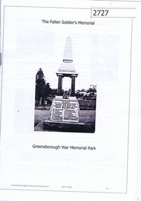 Greensborough Historical Society
Booklet, The Fallen Soldiers' Memorial: Greensborough War Memorial Park, 2016_04
Details of 15 soldiers from the Greensborough district who lost their lives in World War 1. With photos of some of Leigh Conkie's chainsaw sculptures, and of the Greensborough War Memorial (Fallen Soldier's Memorial) first erected in Main Street in 1919, now in the Greensborough War Memorial Park. The booklet was prepared for a group walk around War Memorial Park. Updated October 2019 for Heritage Day talk and BBQ at War Memorial Park. Updated version contains information on Homefront Project chainsaw statues.16p., A5 booklet, black & white and col. photos. Updated 2019greensborough war memorial park, world war i, war memorials greensborough, leigh conkie, fallen soldiers memorial greensborough, homefront project, homefront sculptures -
 Eltham District Historical Society Inc
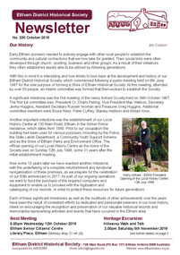
Newsletter, Newsletter, No. 230 October 2016
Contents: • Our History by Jim Connor • Our Next Meeting - Wednesday 12th October • Heritage Excursion - Kileavey Walk and Talk - Saturday 5th November • The Festive Reason by Mal Harrop • History of Maroondah Aqueduct Pipe Bridge over the Plenty River at Greensborough by Anne Paul • One Hundred Years Ago: Eltham and District - July-December 1916 by Liz Pidgeon • From the Hurstbridge Advertiser 2 March 1923 • Refurbishment of our Local History Centre • ... and also • Contacts for the Eltham District Historical Society The Shire of Eltham Historical Society was formed in October 1967. The first newsletter of the Society was issued May 1978 and has been published continuously ever since on a bi-monthly basis. With the cessation of the Shire of Eltham in late 1994, the Society's name was revised to Eltham District Historical Society and this name first appeared with issue No. 103, July 1995. The collection of the Society's newsletters provides a valuable resource on the history of the Society's activities, office bearers and committee members, guest speakers and subjects of historical interest pertinent to the former Shire of Eltham and the Eltham District.A4 photocopied newsletter distributed to membersnewsletter, eltham district historical society, shire of eltham historical society -
 Kiewa Valley Historical Society
DVD - AGL Bogong Power Development & 6 DVDs with students contributions, In Our Backyard
Students from Mt Beauty Secondary College produced this set of 3 DVDs re the development of AGL's Bogong Power Development 2007-2009. This was an addition to the Kiewa Hydro Electric Scheme built by the SECV in the 1950s. The information covers many aspects of the Development which is of interest as well as being educational for the students. The request re the SECV Adit Shaft was to assist with the information board beside the shaft on the Gorges Walk on the West Kiewa River. DVDs were a digital means of passing on information to an audience and enabled multiple copies to be made. The Kiewa Hydro Electric Scheme is in the Kiewa Valley producing clean energy for Victoria. The Bogong Power Development increased the production of electricity in line with more clean energy and gave locals employment and students an insight into its construction and issues. The technical aspect of using DVDs to present this knowledge was also part of the education for the local students. x3 DVDs with hard clear plastic box cover. The cover has a photo on the front with the title typed above it and production details below along with the AGL logo and its Mt Beauty logo.On the back the details (title and content) for each of the 3 DVDs is given. DVD Stories: 1, 2, 4, 7 & 8 and DVD "AGL Photos West Kiewa - In response to letter re photos of Adit Shaft. July 2013"bogong power development project, mt beauty secondary college 2007-2009, agl -
 Marysville & District Historical Society
Booklet (Item) - Leisure guide, Michael Chesire & Associates Pty. Ltd, MARYSVILLE & DISTRICT LEISURE GUIDE-AUTUMN/WINTER, 1986, 1986
A free leisure guide to Marysville and the surrounding district published for Autumn and Winter, 1986. This was produced by Michael Cheshire as a free publication to promote tourism in Marysville and the surrounding district. It includes maps of the Big River Valley, Cumberland Valley, Lady Talbot Forest Drive, the Marysville area, and the township of Marysville. It was released in the autumn of 1986 and was sponsored by the Marysville Tourist & Progress Association. The Association was formed in November 1907 to promote tourism within the area. This included the physical creation of signage, parklands, roads, and walks to various attractions. A free leisure guide to Marysville and the surrounding district published for Autumn and Winter, 1986.marysville, victoria, australia, leisure guide, michael cheshire & associates pty ltd, marysville golf club, blackwood lodges, sir colin mackenzie fauna park, lake eildon, fraser national park, yarra valley wineries, marysville coach tours, kooringa, marylands guest house, lady talbot forest drive, wishing well, taggerty river recreation area, athols abbey, phantom falls, keppel falls, the beeches walking track, marylyn guest house, kufstein inn motel, the cumberland, marysville tourist & progress association, marysville newsagency & general store, crossways restaurant & motel, beauty spot walk, tree fern gully walk, michaeldene track, keppel track, woods lookout track, marysville hotel motel, lake mountain ski hire, marysville recreation and fun park, mytanta horseback safaris, upper big river valley, the big culvert, marysville mountain view horse hire, maryton park, amber view holiday lodges, cathedral restaurant, the top shop, tower motel, menzes garage, beauty spot nursery, marysville ski hire, lake mountain ski school, faraway forest, scenic motel, buxton trout farm, marysville hardware, timbertop steakhouse, marysville trout farm, healesville sanctuary, buxton hotel motel, nanda binya lodge, buxton antique and furniture mart, the black spur inn hotel, alexandra, lake mountain, geoffrey pope & associates -
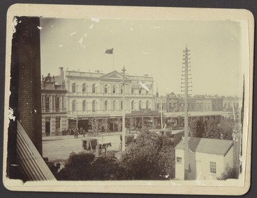
 Federation University Historical Collection
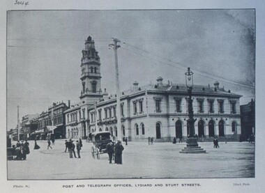
Photograph - Photograph - Black and White, Ballarat Post and Telegraph Office - 1897, 1897
Early photograph of the Ballarat Post Office taken from the intersection of Sturt and Lydiard Streets. A gas lamp stands in the middle of the intersection. People standing and talking on the roads. The Post Office was built in two sections. Section one built in 1864. Section two and the tower were built in 1885. It was built in the Victorian Italianate design. Arched headed windows on the ground floor originally formed a colonnade. These were filled in to provide more internal space. The tower was a feature - the top having a cast iron balustraded widow's walk.Ballarat Post Office - view north along Lydiard Street from its intersection with Sturt Street. Image taken in 1897. Gas lamp in the middle of the intersection. Numerous people are seen standing in the middle of the road talking. There are wires noticeable but cannot verify if they are electric or for the telephone. Electricity was produced in Dana Street Ballarat as early as 1895post office, gas lamp, overhead wires, tower, arched headed windows, victorian italianate design, widow's walk, ballarat post office -
 Otway Districts Historical Society
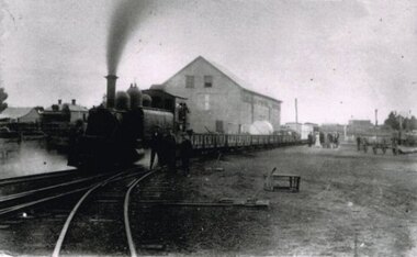
Photograph, Locomotive 8A and its mixed train at Colac Railway Station, c.1920, c.1920
Station facilities for the travelling public on the narrow gauge line at Colac Railway Station were non-existent for many years. Tickets were purchased from the broad gauge booking office and the travellers then had to walk with their luggage over the rough, potentially ankle-twisting, stone approaches, through the goods yard and wait in the open amongst the mud holes alongside the narrow gauge departure track. In 1922 a footbridge was erected over the broad gauge lines, and a passenger shelter and small goods shed were built on the departure track.B/W. At Colac Railway Station, an locomotive 8A with five NQR wagons, an NM livestock wagon and a NBDBD combined passenger and brake van destined for Beech Forest, with either the driver or the fireman peering out of the engine, three youths standing at the front of the engine, and a group of people, including a woman, standing near the livestock wagon. A multi-storied shed and two houses are in the background. 179mm x 280mm picture.colac; railway; narrow gauge; na locomotive; -
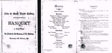 Otway Districts Historical Society
Photograph, Banquet, Opening of Colac-Beech Forest Railway, 1902, 26 Feb 1902
The official opening of the Colac-Beech Forest railway took place on Wednesday, 26th February, 1902. On a typical Beech Forest wet day the train halted at the bottom of Gardner Hill for the opening party led by the State Governor, Sir George Sydenham Clarke, to walk up to the Ditchley Park Hotel for the official banquet in the adjoining hall. The menu of four courses plus coffee was assembed by the caterer, Chas. D. Straker. The toast list was led as usual by a toast to the King, followed by 18 toasts concluded by the Acting Commissioner of Railways.B/W. The menu and toast list at the opening of the Colac-Beech Forest Railway on Wednesday, 26th February, 1902, at Beech Forest. 128mm x 264mm actual -
 Bendigo Historical Society Inc.
Booklet - Victoria Hill
Victoria Hill, accessed from Marong Road, was one of the richest areas on the Bendigo goldfields and was the beginning of reef mining as opposed to alluvial mining. Between 1853 and 1861 there were 16 claims registered on Victoria Hill. Between 1908 and 1910 it was the site of the world's deepest shaft (1365-1406 meters)Today it provides interpretive walks that include sites such as an open-cut mine (1850's), poppet head, quartz crushing battery (1930's) and the foundations of George Lancell's 180 mine. It is registered as a site of historical significance.Clear plastic cover spiral bound booklet of 25 pages. 'Victoria Hill'. A historical background of Victoria Hill and the surrounding area. A colour photo of a poppet head on front. Original story written by Albert Richardson in 1971. This is a revised edition by Philip Wilkin in 2012. Illustrated with colour and B&W photos. Pages 13 to 25 have been inadvertently inserted upside down. A single page A4 leaflet 'Victoria Hill Self Guided Tour' has been put inside after page 1Handwritten in ink on front page 'Donated to Specimen Cottage'victoria hill, gold mine -
 Surrey Hills Historical Society Collection
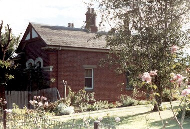
Photograph, Tavistock at 192 Union Road, 1978
The date is approximate. Tavistock was built c1890. The side windows on the front room are a later addition in a different style from the original windows. In 1897 it was the home of the Walker family; Joyce Walker later became matron of Mosgiel Hospital. In 1902 it became the first site of Milverton Girls School. From 1930s to 1960s it was home to Miss Marjorie Vahland, a locally well-known nursing sister. See History Walks No 5, p 11 and p32 Surrey Hills In Celebration of its Centennial 1883-1983Colour photo of the north side of Tavistock at 192 Union Road, Surrey Hills revealed when this side of the property was partially without a fence; taken while re-fencing. The house is Victorian in style, of red brick construction with a patterned slate tile roof and decorative chimneys.tavistock, milverton girls school, victorian style, houses, joyce walker, miss marjorie vahland, nurses -
 Surrey Hills Historical Society Collection
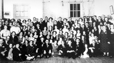
Photograph, Surrey Hills State School, Jubilee Reunion 12 December 1936
Jubilee Reunion 12/12/1936 School No. 2778 established 1886 at first using a Recreation Hall in Albany Crescent near the corner of Windsor Crescent, Surrey Hills. Surrey Hills was first subdivided into urban blocks in 1883 when the train line to Lilydale was opened. Previously the children of local farmers walked to Balwyn school or to a small school in St. Brigids Church which was on the northeast corner of the present Riversdale Road, and Warrigal Road Church. This photo is at Surrey school via Chatham School archives.Photo of a group of past scholars attending a Jubilee Social on 12 December 1936.On front of photo: Old scholars reunion Jubilee Social Surrey Hills No 2778 / 12.12.361936, clothing and dress, people by circumstance, schools, surrey hills state school, festivals and celebrations -
 Vision Australia
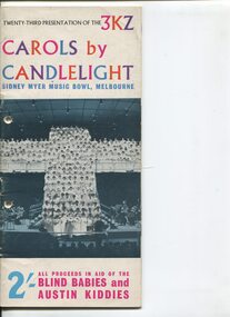
Programme - Text, Twenty-third Presentation of the 3KZ Carols by Candlelight program 1960, 1960
Carols by Candlelight is a Christmas concert held at the Sidney Myer Music bowl. Programs and candle holders were sold, and collections made during the event to raise money for the Austin Hospital and the Royal Victorian Institute for the Blind. 3KZ also recorded the concert, which was played on radio on Christmas Day with a phone number to ring to donate. Prior to the Carols program at 9pm, the performance was opened by the Melbourne Lord Mayer and the process of torchbearers (100 girls dressed in white flowing dresses walk slowly in time with the music to the stage) as a prelude to the event.1 volume with photographs and illustrationscarols by candlelight, austin hospital, margot sheridan, lawrence warner, royal victorian institute for the blind, gwen bowdler, johnny o'keefe, norman swain, bernard evans, philip gibbs, norman k mcleod, syd morgan, dr charles bennett, harold stokes -
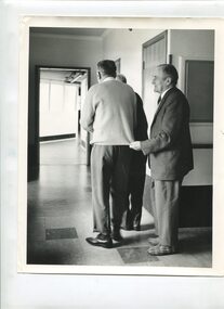 Vision Australia
Photograph - Image, Three men walking along a corridor, 1970-1980s
In the intersection of corridors at a nursing home, three men navigate their way along. The first man has only his lower half and back showing but appears to be guiding his companions. The middle man, dressed in a jumper, shirt, pants and polished shoes walks to his outer left, possibly holding the elbow of the man in front of him. The last man, wearing a jacket, shirt, tie, pants and a pair of snazzy plaid slippers, lightly holds the edge of jumper of the man in front of him, who has turned the corner.1 B/W photograph of three men in a corridor at a nursing home26 2917 C1association for the blind, elanora home (brighton) -
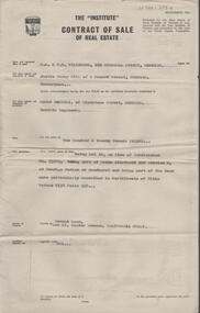 Bendigo Historical Society Inc.
Document - H. A. & S. R. WILKINSON COLLECTION: CONTRACT OF SALE
Contract of sale of real estate dated 3rd December, 1964 between Mr. J. M. Gill (vendor) and Mr. C. Sartori (purchaser). Solicitor for vendor: Messrs. E. S. Cahill & Son, View Street, Bendigo. Solicitor for purchaser: Mr. H. E. Every, Dispensary Walk, Bendigo. Vacant land, Lot 16 hunter avenue, California Gully being lot 16 on plan of subdivision No. 55883 being part of Crown allotment 226 section N land described in certificate of title volume 8158 folio 238. Price 120 pounds.organization, business, h.a. & s.r wilkinson real estate -
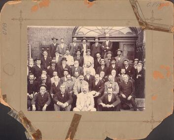 Bendigo Historical Society Inc.
Photograph - BENDIGO STOCK EXCHANGE MEMBERS
Black and white photograph on grey board. Forty six males arranged in front of double doorway with large fan light above. Cast iron gates/fences. CGI tank at L, brick building. Inscriptions: 'GP13' to L and RF corners. On back, hand written in ball point pen 'Bendigo Historical Society', 'Members of Bendigo Stock Exchange taken at rear of Exchange - near Allen's' Walk'. On back - circular rubber stamp 'Royal Historical Society of Victoria, Bendigo Branch'. History: James Lerk 19.11.1999 'Bendigo Stock Exchange members at the rear of the Exchange'.person, group, male group of workers -
 Bendigo Historical Society Inc.
Document - NATIONAL TRUST COLLECTION: THE BEEHIVE, 1987-1988
The Beehive and Old Gold Exchange Hand written letter and one photocopy to Mr Ray Tonkin, Director, Historic Building Council. Photocopy of history assignment by Diane Hartley (98) Letter to Ben Prop of the Property trust. Letter to Ray Tonkin re suggested changes to the Beehive and Allans Walk, Letter to Ben Prop Property Trust informing of classification of the Beehive. Letter to Mr David Martin from Alan Powney re restoration. National Trust Data Form. Letter to Mr D.D. Martin from Ray Tonkin re application to the register of historical buildings.bendigo, buildings -
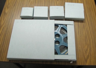 Ballarat Tramway Museum
Film - Movie Film & Box, 1970s
Movie Film - 16mm on a black metal reel, 91mm dia. Title: Train Carriages Interior Shots – Length 1:20 mins, colour, 16mm Colour with sound. (Reg Item 4110 - source not known at this time.) Time Sequence Description 0:00 Starts with a training running past, view of wooden carriages, C van and then interior shots of train, toilets, washbasin, electrical equipment, water dispenser, signs, seats, walk ways between carriages and light fittings. 1:20 End Placed in a blue cardboard box specially made for the item 30/08/2010. trams, tramways, victorian railways -
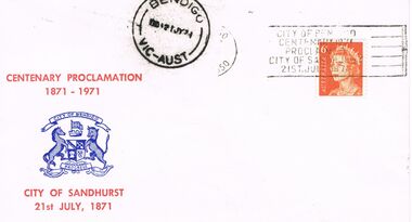 Bendigo Historical Society Inc.
Document - BENDIGO CENTENARY COLLECTION: 1871 ENVELOPE, 21st July, 1971
Cream coloured envelope with red text 'Centenary Proclamation 1871-1971' ''City of Sandhurst 21st July, 1871'' and the City of Greater Bendigo coat of arms on it in blue. A round black stamp containing the words Bendigo No. 21JY71 VIC AUST and another black rectangular one City of Bendigo Centenary of Proclamation City of Sandhurst 21st July, 1871 also adorn the front. So too an orange 6c stamp with HRH Elizabeth II and Australia. On the rear of the envelope in purple stamp is F.M. Martin Killian's Walk (Upstairs Bendigo Ph. 3 2493 and Box 272.bendigo, history, centenary of proclamation -
 Kew Historical Society Inc
Photograph - Misty landscape, c.1927
Henry Beater Christian (1886-1962) , was a descendant of one of the earliest settler families in Kew. Employed at the Kew Asylum as a 'public servant', he was a skilled amateur photographer, photographing numerous scenes in Kew and on his travels around Victoria. The majority of his photographs date from 1916 to 1929. His finest photographs are housed in two photograph albums. Digital copy of a photograph from page 25 of the 47-page photograph album containing 261 gelatinous silver images, loaned by Diane Washfold with permission given to digitise and hold a copy in our collection. John Chapman has written in 'Bushwalking Clubs - A Brief History', about the establishment in Victoria of the first bushwalking club in 1888, and the popularisation of bushwalking during the interwar period. Henry Christian's 'walks' appear to have been undertaken solely or with a companion/s. Here the photographer takes a distant shot of a valley filled with mist and distant mountains which are framed by trees in the foreground.Inscription on page illegiblehenry beater christian (1886-1962), landscape photography, christian-washfold collection, photograph albums, bushwalking -
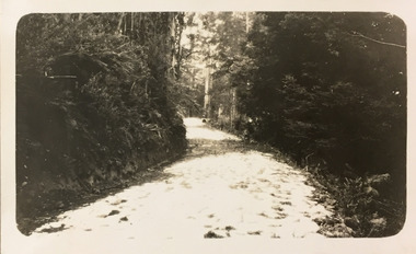 Kew Historical Society Inc
Photograph - Country road, c.1927
Henry Beater Christian (1886-1962) , was a descendant of one of the earliest settler families in Kew. Employed at the Kew Asylum as a 'public servant', he was a skilled amateur photographer, photographing numerous scenes in Kew and on his travels around Victoria. The majority of his photographs date from 1916 to 1929. His finest photographs are housed in two photograph albums. Digital copy of a photograph from page 25 of the 47-page photograph album containing 261 gelatinous silver images, loaned by Diane Washfold with permission given to digitise and hold a copy in our collection. John Chapman has written in 'Bushwalking Clubs - A Brief History', about the establishment in Victoria of the first bushwalking club in 1888, and the popularisation of bushwalking during the interwar period. Henry Christian's 'walks' appear to have been undertaken solely or with a companion/s. Here the photographer takes a snapshot of a winding dirt track/road, thickly forested with native vegetation. The photograph is emblematic of the journey. Inscription on page illegiblehenry beater christian (1886-1962), landscape photography, christian-washfold collection, photograph albums, bushwalking