Showing 9343 items matching "warrandyte"
-
 Ringwood and District Historical Society
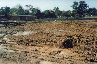
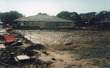
Photograph, Ringwood Bowls Club- Construction of new Bowls Club at corner of Laughnan Road and Warrandyte Road, 1996
Coloured photographPhotograph shows earthworks for greens at new Bowls Club at Laughnan Road. -
 Ringwood and District Historical Society
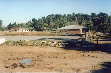
Photograph, Ringwood Bowls Club- Construction of new Bowls Club at corner of Laughnan Road and Warrandyte Road, 1996
Coloured photographPhotograph shows earthworks for greens at new Bowls Club at Laughnan Road. -
 Ringwood and District Historical Society
Photograph, Ringwood Bowls Club- Construction of new Bowls Club at corner of Laughnan Road and Warrandyte Road, 1996
Coloured photographPhotograph shows earthworks for greens at new Bowls Club at Laughnan Road. -
 Ringwood and District Historical Society
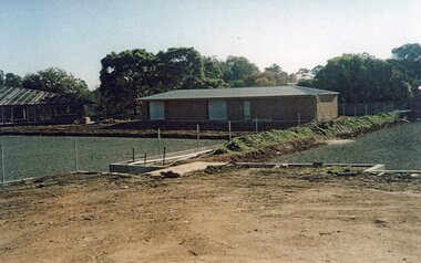
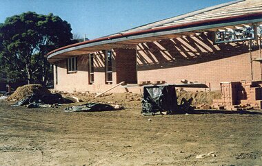
Photograph, Ringwood Bowls Club- Construction of new Bowls Club at corner of Laughnan Road and Warrandyte Road, 1996
Coloured photographPhotograph shows construction of new clubrooms of new Bowls Club at Laughnan Road. -
 Ringwood and District Historical Society
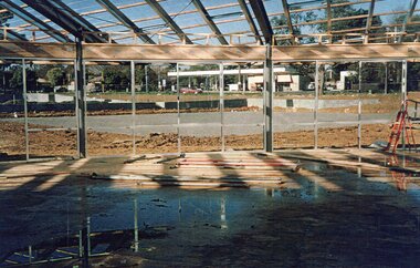
Photograph, Ringwood Bowls Club- Construction of new Bowls Club at corner of Laughnan Road and Warrandyte Road, 1996
Coloured photographPhotograph shows construction of new clubrooms of new Bowls Club at Laughnan Road. -
 Ringwood and District Historical Society
Photograph, Ringwood Bowls Club- Construction of new Bowls Club at corner of Laughnan Road and Warrandyte Road, 1996
Coloured photographPhotograph shows construction of new clubrooms of new Bowls Club at Laughnan Road. -
 Ringwood and District Historical Society
Legal record - Conditions of Sale (C.E.Carter), South Warrandyte , Lot 18, 19, 20 on Plan of Subdivision 12040, Mrs L.E.Collins to Mr N.F.Frangi, 1946
Particulars and Conditions of Sale of Property , from Mrs L.E.Collins to Mr N.F.Frangi, Register No 12040. -
Ringwood and District Historical Society
Legal record - Conditions of Sale (C.E.Carter), South Warrandyte , Lot 8, 9, 10,11, 12 on Plan of Subdivision 15580, Mrs E.Milner and Mr K.G.Thomson, 1944
Particulars and Conditions of Sale of Property , from Mrs E.Milner to Mr K.G.Thomson, Register No 15580. -
Ringwood and District Historical Society
Legal record - Conditions of Sale (C.E.Carter), Warrandyte, Lot (?) on Plan of Subdivision (?), Mr W.E.Aird and (?), Circa 1930
Particulars and Conditions of Sale of Property , from Mr W.E.Aird to (?) -
Ringwood and District Historical Society
Legal record - Conditions of Sale (C.E.Carter), Warrandyte, Lot (?) on Plan of Subdivision (?), Mr W.E.Aird and (?), Circa 1930
Particulars and Conditions of Sale of Property , from Mr W.E.Aird to (?) -
Ringwood and District Historical Society
Legal record - Conditions of Sale (C.E.Carter), Warrandyte, Lot (?) on Plan of Subdivision (?), Mr T.Morris (Solicitor) and (?), 1934
Particulars and Conditions of Sale of Property , from Mr T.Morris (Solicitor). -
 Wonga Park Community Cottage History Group
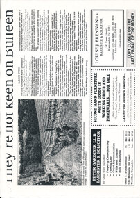
Newspaper (Item) - Cutting, Wonga Park: c. 1994 Warrandyte Diary cutting They're Not Keen On Bulleen
-
 Wonga Park Community Cottage History Group
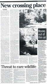
Work on paper - Newspaper cutting, Wonga Park: May 1999, Warrandyte Diary: "New Crossing Place" New bridge for Jumping Creek Road
-
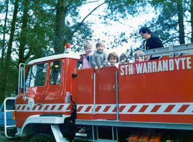 Park Orchards Community House
Photograph, Playgroup at Park Orchards Community Centre with South Warrandyte CFA truck, Unknown date
-
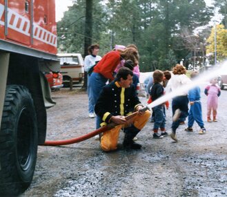 Park Orchards Community House
Photograph, Playgroup at Park Orchards Community Centre with South Warrandyte CFA hosing, Unknown date
-
 Ringwood and District Historical Society
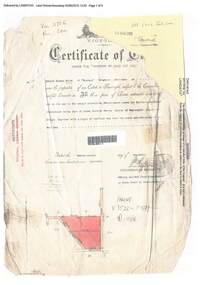
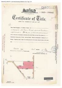
Document, Certificate of Title - Edward Thomas Miles, Gentleman, "Woorara", Ringwood - part of Crown Section 20, Parish of Warrandyte, County of Evelyn - 1913
A4 copies of damaged Landata Victoria Historical Search documents - Vol 3726 Fol 200 - incomplete proprietor and transfer details.Edward Thomas Miles is now the proprietor of an Estate in Fee-simple subject to the Encumbrances notified hereunder ... 27 acres 19 perches or thereabouts, together with a right of carriage way over roads coloured brown. Subdivision map includes un-named roads - western side is Wonga Road (later Warranwood Road), and eastern side is Grandview Grove (later Bemboka Road), both north of Plymouth Road, Ringwood, Vic. Transfers include (illegible) Dobbs, November, 1927 - 5 acres Harry Temple Marshall, 1st December, 1928 - 10ac 3r David Edward Meyland, 4th October, 194-? (illegible). -
 Ringwood and District Historical Society
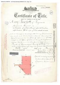
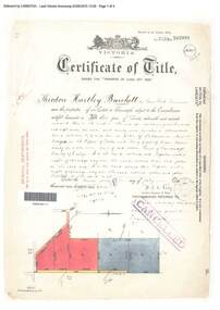
Document, Certificate of Title - Mary Burchett, Lilydale Road, Ringwood - part of Crown Section 20, Parish of Warrandyte, County of Evelyn - 5th July, 1911
A4 copies of Landata Victoria Historical Search documents - Vol 3520 Fol 703990.Mary Burchett of Ringwood, Married Woman, is now the proprietor of an Estate in Fee-simple subject to the Encumbrances notified hereunder ... 50 acres 1 rood 32 perches or thereabouts, being lots 1 and 10 on plan of subdivision no.4315. Subdivision map includes un-named roads - western side is Wonga Road (later Warranwood Road), and eastern side is Grandview Grove (later Bemboka Road), both north of Plymouth Road, Ringwood, Vic. Title transferred to Theodore Hartley Burchett, 27th July, 1911. Encumbrance comment "Special railway condition contained in Grant to Francis Cooke." -
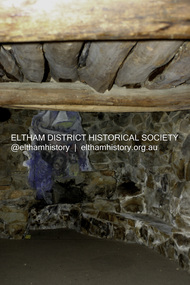 Eltham District Historical Society Inc
Photograph - Digital Photograph, Alan King, Stonygrad, 34 Hamilton Road, North Warrandyte, 30 January 2008
Vassilieff dynamited rock from his own property to build his house. Stonygrad is reminiscent of a grotto and in parts, of a sculpture. Covered under Heritage Overlay, Nillumbik Planning Scheme. Published: Nillumbik Now and Then / Marguerite Marshall 2008; photographs Alan King with Marguerite Marshall.; p135This collection of almost 130 photos about places and people within the Shire of Nillumbik, an urban and rural municipality in Melbourne's north, contributes to an understanding of the history of the Shire. Published in 2008 immediately prior to the Black Saturday bushfires of February 7, 2009, it documents sites that were impacted, and in some cases destroyed by the fires. It includes photographs taken especially for the publication, creating a unique time capsule representing the Shire in the early 21st century. It remains the most recent comprehenesive publication devoted to the Shire's history connecting local residents to the past. nillumbik now and then (marshall-king) collection, danila vassilieff, hamilton road, north warrandyte, stonygrad -
 Ringwood and District Historical Society
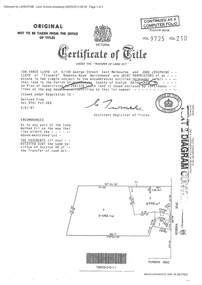
Document - Certificate of Title and Maroondah Heritage Study, "Elouera", 59 Bemboka Road, Warranwood, Victoria, previously part of Crown Section 20, Parish of Warrandyte, County of Evelyn - 4th February, 1987
Property subsequently subdivided into residential allotments with formation of Aspen Court, Warranwood, circa 2010.A4 copies of Landata Victoria documents - Vol 9725 Fol 210 derived from Vol 9701 Vol 469, and 2-page Heritage Study report.Ian Vance Lloyd and June Josephine Lloyd are joint proprietors of an estate in fee simple - Lot 4 on Plan of Subdivision no.204137B shown on the map. Subdivision includes Bemboka Road. Encumbrance E-1 later extended through Lot 4 as Aspen Court. Transfer - Proprietor June Josephine Lloyd - 29 July, 1993. Documents include 2-page Heritage report for study conducted prior to subsequent Aspen Court residential development circa 2010. -
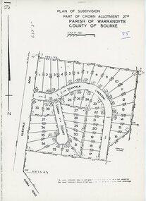 Ringwood and District Historical Society
Map - Plan of Subdivision, Part of Crown Allotment 27B Parish of Warrandyte County of Bourke (undated, circa 1970)
Photocopied subdivision map of 38 residential allotments in Glenvale Road, Cantala Crescent, and Giana Court, north of Kubba Road, Ringwood. -
 Ringwood and District Historical Society
Document, Certificate of Title - W.G. Carter, Grandview Grove, Warranwood, Victoria, (later Bemboka Road) - part of Crown Section Twenty, Parish of Warrandyte, County of Evelyn - 1947
A4 copies of Landata Victoria Historical Search documents - Vol 7052 Fol 1410222. Includes Carter Family Tree property notes. William George Carter of Grandview Grove Ringwood, Nurseryman, is now the proprietor - three acres or thereabouts shown on map (12202a) - 14th March, 1947. Transfer B284834 Registered 21 September, 1961 - 1 acre shown on map (12202c) north of Plymouth Road. NOTES ON GRANDVIEW GROVE PROPERTY (Carter Family Tree extract) The Grandview Grove property was purchased by William (Bill) and Doreen Carter in 1947 as three acres of uncleared bushland. They had a 2 bedroom fibro-cement house built on the land which they informally called "Willoreen". With Doreen looking after sons Peter (born in 1940) and Robin (born in 1950), Bill worked locally at Croydon Dairy. The family spent much of their spare time clearing the land, where Bill then grew and sold fruit, flowers and berries, particularly strawberries, as a hobby and to supplement their income. Bill continued to do so while Peter and Robin were growing up, and after Doreen died in 1958. In 1961 Bill sold one of the three acres to one of his seven sisters, Grace, who lived in Kew but later moved to Rosebud and sold the land without ever building on it. During the 1960s, Grandview Grove was renamed Bemboka Road. After retiring as a milkman, Bill moved to Rosebud, Vic, and in 1977, sold the property to the Anglican Church, who were looking to invest in the site in anticipation of proposed future residential development in the area. As nearby properties were subdivided during the 1980s, the house, which the Church had initially utilised as low-cost family accommodation, was modified internaly to become a church/Sunday school. By the early 2000s, construction of a contemporary-design church and carparking area between the house and street alignment had been completed but the house remained as a detatched meeting room until falling into disrepair and was eventually demolished around 2010. -
 Ringwood and District Historical Society
Document, Certificate of Title - Harry Temple Marshall, Wesburn Farmer, Vic. - part of Crown Section 20, Parish of Warrandyte, County of Evelyn - 1928
A4 copies of Landata Victoria Historical Search documents - Vol 5485 Fol 1096803. Harry Temple Marshall is now the proprietor of an Estate in Fee-simple subject to the Encumbrances notified hereunder ... 10 acres 3 roods 10 perches or thereabouts, together with a right of carriage way over roads coloured brown. Subdivision map includes un-named roads - western side is Wonga Road (later Warranwood Road), and eastern side is Grandview Grove (later Bemboka Road), both north of Plymouth Road, Ringwood, Vic. Transfers include Harold Claude Howship, 1st December, 1928 James Bell McAlpin, 26th March, 1939. -
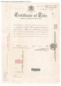
 Ringwood and District Historical Society
Document, Certificate of Title - Theodore Hartley Burchett - part of Crown Section 20, Parish of Warrandyte, County of Evelyn - 1911
A4 copies of Landata Victoria Historical Search documents - Vol 3520 Fol 703991.Theodore Hartley Burchett of Lara Lake, Farmer, is now the proprietor of an Estate in Fee-simple subject to the Encumbrances notified hereunder ... 180 acres 01 rood 27 perches or thereabouts, being lots 1, 8, 9 and 10 on plan of subdivision no.4315. Subdivision map includes un-named roads - lower western side is Wonga Road (later Warranwood Road), and eastern side is Grandview Grove (later Bemboka Road), both north of Plymouth Road, Ringwood, Vic. Transfers include Anna Maria Wicks and Henry James Trowbridge, 3rd October, 1911 Elizabeth Ann Walden, 18th September, 1912 - 28ac 3rds 5per. Edward Thomas Miles, 22nd September, 1913 - 27ac 19per. Samuel Styles, 10th October, 1916 - balance. -
 Ringwood and District Historical Society
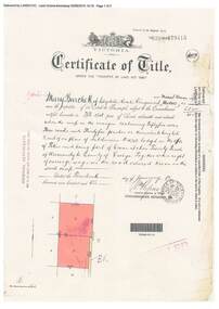
Document, Certificate of Title - Mary Burchett, Lilydale Road, Ringwood - part of Crown Section 20, Parish of Warrandyte, County of Evelyn - 14th January, 1910
A4 copies of Landata Victoria Historical Search documents - Vol 3398 Fol 679415.Mary Burchett of Lilydale Road, Ringwood, Married Woman, is now the proprietor of an Estate in Fee-simple subject to the Encumbrances notified hereunder ... 55 acres 3 roods 35 perches or thereabouts, being lots 8 and 9 on plan of subdivision no.4315. Subdivision map includes un-named road - Grandview Grove (later Bemboka Road, Warranwood, Vic). Title transferred to Theodore Hartley Burchett, 27th July, 1911. -
 Ringwood and District Historical Society
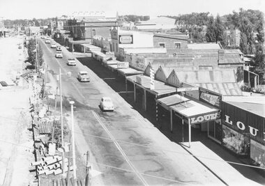
Photograph, Maroondah Highway Central, Ringwood. Looking west from Warrandyte Road, 1960. Taken from clock tower
Black and white photograph (2 copies)Written on back of one copy: "Maroondah Highway looking west from clock tower, 1960. Road being reconstructed." -
 Ringwood and District Historical Society
Map - Plans of Subdivision, Part of Crown Allotments 35 & 39, Parish of Warrandyte
Survey maps of stages 1, 2 & 3 of residential allotments in Kalinda Road and Grayling Crescent, Ringwood, Victoria. (Undated, circa 1960). Some allotments are marked with real estate information and prices in pre decimal £s.Adshead & McGuire, Land Surveyors L.S. M.I.S. (Aust), 268 Albert Street East Melbourne (Ref 118/2a b &c) Tel 41-6960. The land colored blue is set apart for drainage & sewerage purposes. Reference Marks (R.M's) are Gal Iron Pipes 12"x1". Levels shown are to M.M.B.W. Datum. The land shown hatched is subject to innundation. -
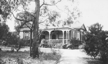 Ringwood and District Historical Society
Photograph, Home of Augustus Temple Miles - 48 Warrandyte Road, Ringwood. c1960's
Black and white photograph of house and garden.(2 copies- 1 Large, 1 small)Written on rear of backing sheet: "Home of Augustus Temple Miles, c1960's. A.T. Miles was the first Mayor of Ringwood in 1924. Born Hobart 1880, died Ringwood 1962. -
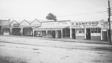 Ringwood and District Historical Society
Photograph, Maroondah Highway Central, Ringwood. P. Bamford store, corner Warrandyte Road. c1924
Black and white photograph (2 copies) Site later to become Safeway store. -
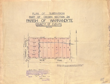 Ringwood and District Historical Society
Map - Plan of Subdivision, Part of Crown Section 24, Parish of Warrandyte, County of Evelyn - 1951
Survey map of residential allotments in Berringa Road and Milne Road, Park Orchards, Victoria. Russell Francis Kinnane, Licensed Surveyor, 4th October, 1951. -
 Ringwood and District Historical Society
Map - Plan of Subdivision, Part of Crown Section 24, Parish of Warrandyte, County of Evelyn - undated, circa 1951
Survey map of residential allotments in Milne Road, east of Berringa Road, Park Orchards, Victoria.