Showing 110292 items matching "roads"
-
 Phillip Island and District Historical Society Inc.
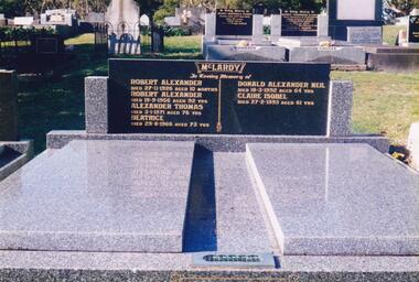
Photograph Album, Kodak, Phillip Island Cemetery, c 1990
The Album was compiled by Nancy McHaffie late 1990's, with the assistance of Edith Jeffery's, with her book "Garden of Memories" and extensive knowledge of Phillip Island. The Cemetery lies back from the road and is surrounded by Manna Gums, rare Peppermint Gums, Blackwoods and other native trees. In all 25 acres of land were set aside as Crown Land in the land settlement of 1868. There are 6.2 acres of wetlands near the cemetery entrance.466-56: Alexander McLardy Sr. The descendants of Alex McLardy came to Phillip Island in the year 1886. A builder by trade, he built a great number of houses and buildings on the Island. He was also the founder of the Guesthouse "Glencoe". At 90 years of age he could still read well without the aid of glasses. He died in 1956 aged 95. Others buried in the double graves are: Robert Alexander died 1926 aged 10 months, Alexander Thomas died 1971 aged 76, Beatrice died 1966 aged 73, Donald Alexander died 1992 aged 64 and Claire Isobel died 1993 aged 61. 466-57: Walter Findlay. Walter's parents George and Mary, came to Australia in 1852. Walter was born in Sale circa 1883. He married Henrieta Kennon and they lived and farmed in Settlement Road, Cowes prior to their shop and residence being built in Warley Avenue, Cowes. The shop carried general merchandise and confectionery. The property was absorbed by Bass Coast Family Medicine on the west side of Warley Avenue. Henrieta died September 1965 aged 84. Walter died July 1965 aged 82.phillip island cemetery, alexander mclardy, walter findlay, nancy mchaffie, edith jeffery -
 Orbost & District Historical Society
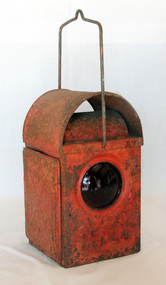
lantern
The kerosene lantern is a type of lighting device that uses kerosene as a fuel. Kerosene lanterns have a wick or mantle as light source. They may be hand-held for portable lighting.This kerosene lantern was used as a light on road works in the Orbost area. It would have been carried/used by one of the road workers. Lamps of this kind were significantroadworks items in their period of use as essential tools to the safe-working operations of the Country Roads Board.. A red metal roadworks warning lantern. It is rectangular with a metal carrying handle. The top is domed. The door at the back is hingedand opens with a small nail. The lamp was lit by kerosene held in a small square tank with a wick.lantern kerosene light lamp -
 Eltham District Historical Society Inc
Negative - Photograph, J.A. McDonald, Sherbourne Road, Montmorency, c. July 1962
View looking west across Sherbourne Road to intersection of Rattray Road from present-day forecourt entrance to 7-Eleven Eltham service station The BP Service Station is now an Ampol Service Station (2022) Google Street View Apr.. 2022 https://goo.gl/maps/LM4APKCwj1ohBDPv5Record of various Shire of Eltham infrastructure works undertaken during the period of 1952-1962 involving bridge and road reconstruction projects, sometimes with Eltham Shire Council Project Reference numbers quoted. It was during this period that a number of significant improvements were made to roads and new bridges constructed within the shire that remain in place as of present day (2022). In many situations, the photos provide a tangible visible record of infrastructure that existed throughout the early days of the Shire. The album was put together by or under the direction of the Shire Engineer, J.A. McDonald.1962-07, ampol service station, bp service station, montmorency, rattray road, service station, sherbourne road, graders, infrastructure, public telephone box (red), reconstruction works, road construction, shire of eltham -
 Eltham District Historical Society Inc
Negative - Photograph, J.A. McDonald, Sherbourne Road, Montmorency, c. July 1962
View looking west across Sherbourne Road to intersection of Rattray Road from present-day forecourt entrance to 7-Eleven Eltham service station The BP Service Station is now an Ampol Service Station (2022) Google Street View Apr.. 2022 https://goo.gl/maps/LM4APKCwj1ohBDPv5Record of various Shire of Eltham infrastructure works undertaken during the period of 1952-1962 involving bridge and road reconstruction projects, sometimes with Eltham Shire Council Project Reference numbers quoted. It was during this period that a number of significant improvements were made to roads and new bridges constructed within the shire that remain in place as of present day (2022). In many situations, the photos provide a tangible visible record of infrastructure that existed throughout the early days of the Shire. The album was put together by or under the direction of the Shire Engineer, J.A. McDonald.1962-07, ampol service station, bp service station, montmorency, rattray road, service station, sherbourne road, infrastructure, reconstruction works, road construction, shire of eltham -
 Glen Eira Historical Society
Pamphlet - Uniting Church Archives, Orrong Road, 78-66, Elsternwick
Documents relating to Centenary: An invitation to 100th Anniversary Celebration at Orrong Road Uniting Church Elsternwick, dated November 15, 1987. Orrong Road Methodist Church History from 14/11/1887 to 14/11/1978 compiled by Norma Ward. List of names included in File 1235B.orrong road uniting church, elsternwick, crabtree w., ward norma, adams l., lowsby l., coombe m. rev., johnson l. rev. -
Glen Eira Historical Society
Letter - Bambra Road, 348, Caulfield
Print of email from Stan Marks to Glen Eira Historical Society requesting information about 348 Bambra Road, Caulfield, dated 06/06/2013. Handwritten research note dated 04/07/2013 by Peta Darke with list of residents at 348 Bambra Road in various years.bambra road, marks stan, caulfield, glen eira, caulfield council, houses -
 Greensborough Historical Society
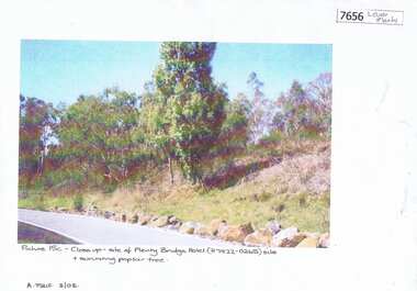
Photograph - Photograph (Copy), Anne Paul, Plenty Bridge Hotel site, 2003_03
21st century photograph of heritage site: former Plenty bridge Hotel and Tollhouse, situated on the eastern side of Old Lower Plenty Road, near the Old Lower Plenty Road Bridge on the east bank of the Plenty River. Although the Hotel burnt down, poplar trees still exist on the site.3 pages, 1 x colour photograph printed on paper, 1 x Heritage Inventory (text) and 1 historic black and white photo.On colour photograph: Close-up site of Plenty Bridge Hotel (H7922-0265) and surviving poplar tree. A. Paul 3/03plenty bridge hotel, lower plenty, plenty river -
 Eltham District Historical Society Inc
Photograph, Wattletree Road Bridge, Eltham, c. August 1977, 1977
Traffic island at intersection is lined with white-painted bluestone edging which originally was part of the Eltham lock-up situated at 728 Main Road. The bluestone has since been re-used (from late 1980s) at the rear of 728 Main Road to form the garden bed in car park. Colour photographeltham, infrastructure, main road, shire of eltham infrastructure, wattletree road bridge, bridge -
Glen Eira Historical Society
Newspaper - Shoobra Road, 67, Elsternwick
This file has two items. Melbourne weekly bayside dated 29/09/2010, auction article on 67 Shoobra Road: original interiors and selling features, includes four photographs of property. Newspaper article on forthcoming sale of 67 Shoobra Road 2010, with two identical photos to above.victorian style, bluestone, lead lights, plaster moulds, biggin and scott, blair mrs d, glenhuntly road, glen huntly road, elsternwick, shoobra road, marble, fireplaces, topp mrs louise, bay windows, yarrawah, house names, wise andrew. m, mascotte, coy chas. e, collins jas. d, bromfield stewar.t p, adam stnly., forster edwd. c, dickson rnld. s -
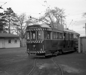 Ballarat Tramway Museum
Photograph - Digital Image, Peter Knife, SEC 43 squeezing into Road 0 at Ballarat Depot, 14/8/1965
Digital image of SEC 43 squeezing or turning into Road 0 at Ballarat Depot. Tram has an electric cooking roof advert. Photo by Peter Knife 14 Aug 1965. This track "0 Road" was built to accommodate bogie cars in the mid-1950s, a set of very sharp reverse curves. Yields information about Ballarat's trams in August 1965.Digital image of a black and white negativetramways, tramcars, ballarat, tram 43, sec depot, 0 road -
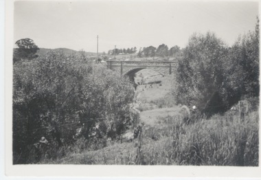 Sunbury Family History and Heritage Society Inc.
Photograph
The single span bluestone bridge is on the Calder Highway at the base of Corkscrew Hill between Gap Road and the town of Gisborne. In the early 1990s the highway was widened and dual carriageways constructed, as a result the traffic no longer travelled along the winding Corkscrew Hill road. The bridge still stands between the two carriageways. A black and white photograph with a cream border of a single arched stone bridge spanning a watercourse. Small bushes are growing in the foreground and there are some buildings dotted across the hill in the middle distance.bridges, corkscrew hill, calder highway -
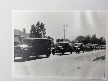 Surrey Hills Historical Society Collection
Photograph, Dame Nellie Melba funeral procession, Original: 1931
Funeral of Dame Nellie Melba, photographed in 1931 passing along Whitehorse Road en route to the Lilydale Cemetery by Mrs Emma Atkinson, who with her husband, William James Atkinson, had a shop near the corner of Elgar Road. The hearse is followed by three ‘buckboards’ bearing floral tributes. A black and white photograph of a line of cars, some carrying many flowers.whitehorse road, lilydale cemetery, funeral, mrs emma atkinson, dame nellie melba, miss emma uebergang, surrey hills, funeral processions -
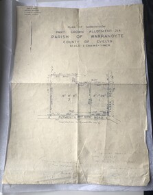 Luther College
Map, Plan of Subdivision, 1957
This map shows the original subdivision of land on the corner of Plymouth Road and Yarra Road. The land previously belonged to Phillip Brucker, who used the property as a small farm. Brucker offered his land at a reduced price to the Lutheran Church, who were seeking a location for their new secondary school endeavour.This is the oldest map of Luther Collegemap, building plans -
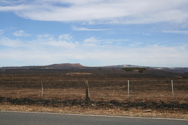 Sunbury Family History and Heritage Society Inc.
Photograph, Rosa McCall, Riddell Road, February 2014
In February 2014 severe grassfires blazed across the land north of Sunbury from the Calder Highway across Riddell Road and on to Clarkefield and beyond and caused damage to the Bendigo Railway line. This image was taken about a week later along Riddell Road and looking SW to Red Rock across the skyline.This grass fire caused much damage across a large area north of Sunbury and beyond.A coloured photograph of an open landscape that has been extensively burnt after grassfires.grass fires, riddell road, red rock, sunbury -
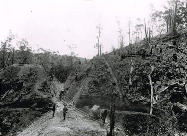 Otway Districts Historical Society
Photograph, Brucker, Powneys Cutting being excavated, c.1902, c.1902
Because of the vast quantity of piles for harbour works Pettit Bros. of Geelong arranged for an addition siding to be installed at Ferguson on the north side of the station in 1913. They then laid a tramway in a northerly direction along the original alignment of Charley's Creek road to the top of Powneys Cutting, 1.8 km from Ferguson, where a log winch was sited. This powerful winch hauled carefully selected piles from the north-west. Jim Facey and Jim, Ted and Tom Cashin formed a partnership to log an area along the Charley's Creek Road six kilometres from Ferguson, operating full-time from 1934. After leasing three Crown sites and cutting them out the partners shifted logging operations to Powneys farm, which they had purchased, and laid a log trail into the farm. The old road reserve was also purchased, and the log tram continued along the road reserve for one kilometre to Powneys Cutting. Logs were winched up to the tramline and despatched to the mill along the falling grade of the road.B/W. 201mm x 268mm. Powneys Cutting being excavated by four men, two men on either side of the slope, and a horse at the end of the line, in c.1902.ferguson; powneys cutting; tramways; powneys farm; pettit; jim facey; jim cashin; ted cashin; tom cashin; charley's creek road; -
 Kew Historical Society Inc
Album - Scrapbook, Eva Grant, Historic Buildings, Kew, 1958-78, 1970s
One of three scrapbooks of photographs and newspaper cuttings taken and or collected by Eva Grant, a past member of the Kew Historical Society, which were donated by her niece, Julie Thomson. The albums include many photographs of Kew from the 1950s to the 1970s. Buildings included in the scrapbook include: Billy Hughes' house - 167 Cotham Road Congregational Church - Walpole Street (c.1978) Country Roads Board - Denmark Street (1960) Dorothy Rogers Reserve - Studley Park Road Ellsmere (also Ellesmere/Ellsmore) - Princess Street Field Place - 3 Henty Court Fernhurst - 13 Fernhurst Grove Kew Civic Centre (1959) Kew Junction (1958) Kew Railway Station (1902, 1959) Kew Recreation Hall - Wellington Street (1960) Neama (Hall) - Studley Park Road Southesk (formerly Ordsall) - Cotham Road (c.1960) St Anthony's Home for Babies (formerly Madford) - 43 Wellington Street (c.1976) Studley House - Nolan AvenueThe scrapbook contains historically significant, rare and sometimes unique images of significant heritage buildings in Kew, including their erection and demolition. 11-page scrapbook of photographs and newspaper clippings with annotations by Eva Grant, a past member of the Kew Historical Society. The pages of the album can be viewed in the image carousel above. Based on the text and known dates of demolition of a number of the buildings, the scrapbook was assembled over a twenty year period between c.1958-c.1978.Includes letter from donoreva grant, billy hughes' house - 167 cotham road, congregational church - walpole street - kew, country roads board - denmark street - kew, dorothy rogers reserve - studley park road - kew, field place - 3 henty court - kew (vic), ellsmere (also ellesmere/ellsmore) - princess street - kew, fernhurst - 13 fernhurst grove - kew (vic), kew civic centre - civic drive - kew (vic), kew junction - kew (vic), kew railway station - denmark street - kew (vic), recreation hall - wellington street - kew, neama - hall - studley park road - kew (vic), southesk - ordsall - cotham road- kew (vic), st anthony's home for babies - madford - 43 wellington street (vic), studley house - nolan avenue - kew (vic) -
 Kew Historical Society Inc
Plan, Melbourne & Metropolitan Board of Works : Borough of Kew : Detail Plan No.1572, 1905
The Melbourne and Metropolitan Board of Works (MMBW) plans were produced from the 1890s to the 1950s. They were crucial to the design and development of Melbourne's sewerage and drainage system. The plans, at a scale of 40 feet to 1 inch (1:480), provide a detailed historical record of Melbourne streetscapes and environmental features. Each plan covers one or two street blocks (roughly six streets), showing details of buildings, including garden layouts and ownership boundaries, and features such as laneways, drains, bridges, parks, municipal boundaries and other prominent landmarks as they existed at the time each plan was produced. (Source: State Library of Victoria)This plan forms part of a large group of MMBW plans and maps that was donated to the Society by the Mr Poulter, City Engineer of the City of Kew in 1989. Within this collection, thirty-five hand-coloured plans, backed with linen, are of statewide significance as they include annotations that provide details of construction materials used in buildings in the first decade of the 20th century as well as additional information about land ownership and usage. The copies in the Public Record Office Victoria and the State Library of Victoria are monochrome versions which do not denote building materials so that the maps in this collection are invaluable and unique tools for researchers and heritage consultants. A number of the plans are not held in the collection of the State Library of Victoria so they have the additional attribute of rarity.Original survey plan, issued by the MMBW to a contractor with responsibility for constructing sewers in the area identified on the plan within the Borough of Kew. The plan was at some stage hand-coloured, possibly by the contractor, but more likely by officers working in the Engineering Department of the Borough and later Town, then City of Kew. The hand-coloured sections of buildings on the plan were used to denote masonry or brick constructions (pink), weatherboard constructions (yellow), and public buildings (grey). Plan No. 1572 represents the built environment bordered by Barkers Road, Wrixon Street, Edgevale Road and Fitzwilliam Street. Other streets identified on the plan include Stansell Street. Plan 1572 shows that by 1903-05, there was only patchy development in this area of Kew, mainly on Edgevale Road and Fitzwilliam Street. Only two named houses are identified: the quaintly named ‘Tweed Cottage’, and ‘Mendip’. The earliest reference to Treed Cottage in Australian newspapers is to the death of Walter Thompson, aged 74 who was a resident there in 1885. His youngest daughter was to die there in 1908. Mendip to the north of Tweed Cottage was owned by Henry Thompson; he was to die in 1901; his wife in 1932. At this period of time, Malin Street and Clivedon Court did not extend to Barkers Road.melbourne and metropolitan board of works, detail plans, mmbw 1572, cartography -
 Wodonga & District Historical Society Inc
Photograph - Terminus Hotel, Wodonga, C. 1906
The Terminus Hotel, Wodonga was built by James Thompson Hatch in 1873, the same year the railway reached Wodonga from Melbourne. It was named due to its close proximity to the railway terminus. It was sold to Messrs George Day and Kenneth McLennan of Albury. It was first licenced to J.G. Morton in January 1874. Annie Allen, from Ireland, took over as licensee of the hotel containing 14 rooms in 1879, after she and her husband, George James Allen, purchased it. In 1887 they added a new wing on the south boundary of the property next to Peter McLean’s store at 81 Sydney Road. The architects for the new wing were Gordon and Gordon. A billiard room, a dining room, and 18 other rooms were added on the vacant block of land between the Hotel and the Bank of Victoria. A balcony 6 feet wide was added on the north side. Included in the plans was the latest patent elevator, later known as a dumb waiter. Allen died in 1889 aged 52, and Annie Allen continued to run the Terminus. She later married John G. Haldon and was licensee of the hotel until December 1898 when the licence was transferred to William Carkeek. Carkeek, from Cornwall, arrived in the colony around 1860 and is considered one of the founders of Tallangatta. In November 1903, the license was transferred to Daniel Crawford, then in 1906 it was transferred to Mr Stephen Carkeek. In 1916 it passed into the hands of Mr H. W. Allen of Rutherglen, son of Mr George James Allen. Between 1916 and 1933 there were a variety of licensees. In October 1933, the stables and garage at the rear of the Terminus Hotel were totally destroyed by fire. In 1935, the Terminus again underwent a series of improvements and extensions at the cost of £3,000. The front of the premises was extended in the fashionable Spanish mission style. The balcony of brick and concrete was extended to be 18 feet wide, wire gauged and fitted with glass slides and a tile roof. In addition to 15 new bedrooms, four more bathrooms, making seven in all, were available for patrons. These were on the second floor, while beneath them provision was made for four shops and a new kitchen and a laundry. Throughout the 1930s and 1990s the licensee and owners changed several times. On 1st June 1998 the Terminus Hotel was destroyed by fire. Estimates of damage range from between a conservative $750,000 to as high as $2 million. The remains of the building were demolished in 1999.The Terminus Hotel was one of the earliest hotels in Wodonga with clear links to the establishment of the railway line. It was an important business and meeting place for social gatherings.Allen's Terminus Hotel in Main Street (known as Sydney Road and later High Street, Wodonga). This image is dated as November 1906, however research suggests the hotel was operated by the Carkeek family and then and also Mr. Daniel Crawford prior to this date. The Terminus was sold by auction on 5th March 1909 as part the estate of Annie Haldon. Annie Allen had married John George Haldon in 1890.Across front of building "ALLENS TERMINUS HOTEL"hotels wodonga, businesses wodonga, terminus hotel wodonga -
 Ballan Shire Historical Society
Map - Map. Korweinguboora, Department of Lands and Survey, Korweinguboora. Counties of Talbot and Grant
A map of the Korweinguboora area showing roads, forests, railway lines and properties with the owners names.The inclusion of the names of landowners is of significance and value to historians.A map of the Korweinguboora area showing land subdivisions and names of owners and other physical features. There is a scale in chains. No date is certain but it could be 1902. The map has been repaired with sellotape.There are various pencil annotations but the are difficult to read.talbot, moorarbool west, wombat, bullarto, korweinguboora, moorarbool east, dean, wombat state forest, barkstead -
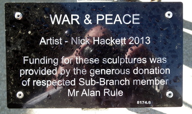 Bendigo Military Museum
Sculpture - WAR & PEACE FIGURES, Nick Hackett, C.2013
This display is situated on the RH side of the front entrance to the Bendigo District RSL in Havilah RoadSix metal sculptures representing the. Australian Army, Navy, Airforce, Women in the Forces over time during War & Peace. Consists of 4 figures standing, 1 kneeling with a child standing. Plaque black colour on a stand with white text re the Artist and Donor. The dimension shown is an average of the standing figures.As per the photo of the plaque.brsl, smirsl, bdrslinc, sculpture -
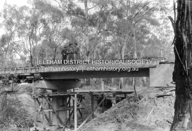
 Eltham District Historical Society Inc
Album - Photograph, J.A. McDonald, Heidelberg-Kinglake Road, Jan. 1956
Hurstbridge-Kinglake Road at Cottlesbridge south Pill’s Corner before reconstruction January 1956Record of various Shire of Eltham infrastructure works undertaken during the period of 1952-1962 involving bridge and road reconstruction projects, sometimes with Eltham Shire Council Project Reference numbers quoted. It was during this period that a number of significant improvements were made to roads and new bridges constructed within the shire that remain in place as of present day (2022). In many situations, the photos provide a tangible visible record of infrastructure that existed throughout the early days of the Shire. The album was put together by or under the direction of the Shire Engineer, J.A. McDonald.infrastructure, shire of eltham, bridge construction, heidelberg-kinglake road, road construction, cottlesbridge, 1956-01 -
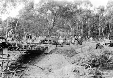
 Eltham District Historical Society Inc
Album - Photograph, J.A. McDonald, Henley Road Bridge over Watsons Creek, Aug. 1962
Henley Road Bridge over Watsons Creek Yarra Glen Abutment August 1962Record of various Shire of Eltham infrastructure works undertaken during the period of 1952-1962 involving bridge and road reconstruction projects, sometimes with Eltham Shire Council Project Reference numbers quoted. It was during this period that a number of significant improvements were made to roads and new bridges constructed within the shire that remain in place as of present day (2022). In many situations, the photos provide a tangible visible record of infrastructure that existed throughout the early days of the Shire. The album was put together by or under the direction of the Shire Engineer, J.A. McDonald.H941 stamped on reverse (film processing #)infrastructure, shire of eltham, bridge construction, road construction, bushfires, 1962-08, bend of islands, henley road, henley road bridge, kangaroo ground, oxley bridge, watsons creek -
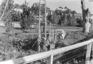
 Eltham District Historical Society Inc
Album - Photograph, J.A. McDonald, Henley Road Bridge over Watsons Creek, Sep. 1962
Henley Road Bridge over Watsons Creek Yarra Glen Abutment September 1962Record of various Shire of Eltham infrastructure works undertaken during the period of 1952-1962 involving bridge and road reconstruction projects, sometimes with Eltham Shire Council Project Reference numbers quoted. It was during this period that a number of significant improvements were made to roads and new bridges constructed within the shire that remain in place as of present day (2022). In many situations, the photos provide a tangible visible record of infrastructure that existed throughout the early days of the Shire. The album was put together by or under the direction of the Shire Engineer, J.A. McDonald.H941 stamped on reverse (film processing #)infrastructure, shire of eltham, bridge construction, road construction, bushfires, bend of islands, henley road, henley road bridge, kangaroo ground, oxley bridge, watsons creek, 1962-09 -
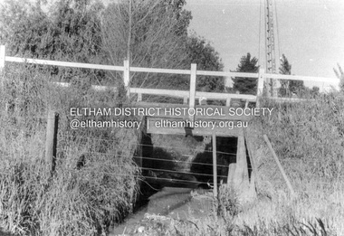
 Eltham District Historical Society Inc
Album - Photograph, J.A. McDonald, Cecil Street Bridge, Eltham-Yarra Glen Road, Eltham, Oct. 1962
Eltham-Yarra Glen Road Cecil Street Bridge Looking upstream Oct. 1962Record of various Shire of Eltham infrastructure works undertaken during the period of 1952-1962 involving bridge and road reconstruction projects, sometimes with Eltham Shire Council Project Reference numbers quoted. It was during this period that a number of significant improvements were made to roads and new bridges constructed within the shire that remain in place as of present day (2022). In many situations, the photos provide a tangible visible record of infrastructure that existed throughout the early days of the Shire. The album was put together by or under the direction of the Shire Engineer, J.A. McDonald.H941 stamped on reverse (film processing #)infrastructure, shire of eltham, bridge construction, road construction, 1962-10, bible street reserve, cecil street bridge, eltham, eltham-yarra glen road, main road -
 Eltham District Historical Society Inc
Album - Photograph, J.A. McDonald, Cecil Street Bridge, Eltham-Yarra Glen Road, Eltham, Oct. 1962
Eltham-Yarra Glen Road Cecil Street Bridge Looking upstream Oct. 1962Record of various Shire of Eltham infrastructure works undertaken during the period of 1952-1962 involving bridge and road reconstruction projects, sometimes with Eltham Shire Council Project Reference numbers quoted. It was during this period that a number of significant improvements were made to roads and new bridges constructed within the shire that remain in place as of present day (2022). In many situations, the photos provide a tangible visible record of infrastructure that existed throughout the early days of the Shire. The album was put together by or under the direction of the Shire Engineer, J.A. McDonald.H941 stamped on reverse (film processing #)infrastructure, shire of eltham, bridge construction, road construction, 1962-10, cecil street bridge, eltham, eltham-yarra glen road, main road -
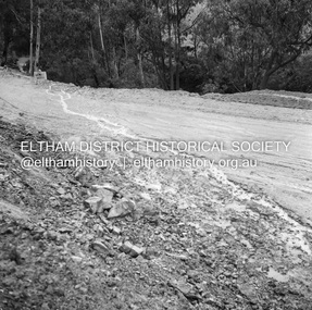 Eltham District Historical Society Inc
Negative - Photograph, J.A. McDonald, Heidelberg-Kinglake Road, Sep 1959
Job 56M430 Contractor Hone Wash over road due to blocked table drainRecord of various Shire of Eltham infrastructure works undertaken during the period of 1952-1962 involving bridge and road reconstruction projects, sometimes with Eltham Shire Council Project Reference numbers quoted. It was during this period that a number of significant improvements were made to roads and new bridges constructed within the shire that remain in place as of present day (2022). In many situations, the photos provide a tangible visible record of infrastructure that existed throughout the early days of the Shire. The album was put together by or under the direction of the Shire Engineer, J.A. McDonald.infrastructure, shire of eltham, bridge construction, 1959-09, heidelberg-kinglake road, road construction -
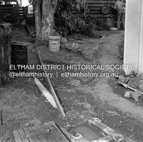 Eltham District Historical Society Inc
Negative - Photograph, J.A. McDonald, Para Road, Mar. 1961
Wash out 51 Para Road after heavy rain 28 March 1961Record of various Shire of Eltham infrastructure works undertaken during the period of 1952-1962 involving bridge and road reconstruction projects, sometimes with Eltham Shire Council Project Reference numbers quoted. It was during this period that a number of significant improvements were made to roads and new bridges constructed within the shire that remain in place as of present day (2022). In many situations, the photos provide a tangible visible record of infrastructure that existed throughout the early days of the Shire. The album was put together by or under the direction of the Shire Engineer, J.A. McDonald.infrastructure, shire of eltham, 1961-03, flood damage, para road -
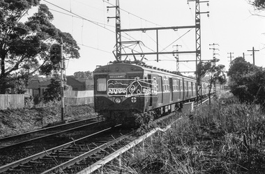 Eltham District Historical Society Inc
Photograph, George Coop, Harris (Blue) electric train approaching Mont Albert Railway Station, c.Feb. 1964
Climbing the hill from Surrey Hills having just crossed Mont Albert Road.Digital TIFF file Scan of 35mm Ilford FP3 black and white transparencygeorge coop collection, harris (blue) train, mont albert railway station -
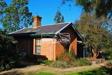 Eltham District Historical Society Inc
Photograph, Jim Connor, Main Road, Eltham, 3 Jul 2013
Former Police House (1859) and Local History Centre, 728 Main Road, ElthamTomorrow's history documented todayeltham, jim connor collection, local history centre, main road, police residence -
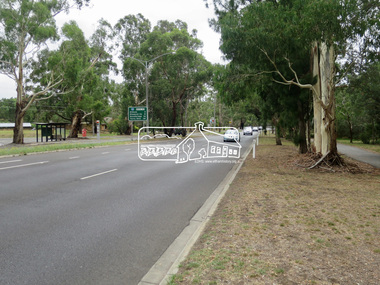 Eltham District Historical Society Inc
Photograph, Jim Connor, Main Road, Eltham, 14 Jan 2017
Eltham Gateway, Looking north along Main Road near Eltham Lower ParkTomorrow's history documented todayeltham, jim connor collection, main road, eltham gateway