Showing 1743 items matching " concrete"
-
 Port Melbourne Historical & Preservation Society
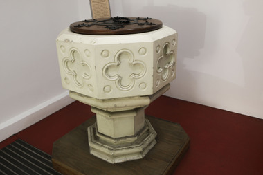
Ceremonial Object - Baptismal Font, Holy Trinity Anglican Church, Port Melbourne, Jim Hillis
On the pending sale of Holy Trinity church, this baptismal font was removed from the church for safe keeping by the Society and placed in storage at McClusy's garage. When McClusky moved out in 1997, the font was again removed and placed in sections in the Spring Street foyer of the Port Melbourne Town Hall. In February 1998 it was assembled by members of the Society.Baptismal font, eight sided, ornamental, free standing, in three sections: base, column, water bowl; made of concrete and finished in plaster of Paris for relief sculptures; painted an off-white. Base of Tasmanian oak added in 1998. Pic ref item 1485.02religion - anglican (holy trinity) -
 Tatura Irrigation & Wartime Camps Museum
Photograph, 20/11/1956
Taken by photographer for State Rivers and Water Supply Commission.Medium sized black and white photograph. Big wash-away under concrete slab at Tatura Waterworks storage / Sheets of galvanised iron foreground on slab / bags of sand and petrol drum further along above water level / water on right / tree on horizon.victorian state rivers and supply commission, tatura waterworks, tatura waterworks trust -
 Hume City Civic Collection
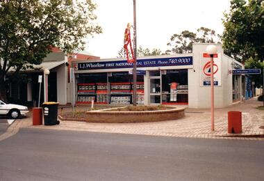
Photograph, Prior to 1995
This corner was occupied in the past by Lloyds Chemist shop which was a weatherboard structure. The photograph was taken prior to 1995 when 8 digit telephone numbers were introduced throughout the Metropolitan area.A coloured photograph of the streetscape of the SW corner of Evans and Brook Street. The main shop is occupied by L. J Whorlow, Real Estate Agents. A white car is parked on the LHS of the photograph and a garbage bin is placed next to a concrete bollard by the kerb and on the brick paved footpath.real estate agents, shopping centres, whorlow, l. j., lloyd, l. m., first national real estate, evans street, brook street, george evans collection -
 Kew Historical Society Inc
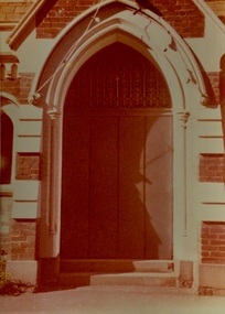
Photograph - Entrance, Kew Congregational Church, Walpole Street, 1978
The site of the former Kew Congregational Church was the earliest 'built' place of religion in Kew. An earlier building by Charles Vickers was replaced by a new brick church designed by Albert Purchas. Following the creation of the Uniting Church, the church at 30 Walpole Street was declared redundant and demolished to make way for the Bodalla Nursing Home (itself later demolished).Faded colour photograph of an entrance door of the Kew Congregational Church in Walpole Street (Dem. 1978/9). The single door had an ornate iron grill above it. The door was set within a concrete stucco neo-Gothic arch surrounded by red brick work."KH-137 / Donated by H. Gielen / Former Congregational Church"kew congregational church, architects -- albert purchas, churches -- kew (vic.), walpole street -- kew (vic.), congregational churches -- melbourne (vic.) -
 Lakes Entrance Historical Society
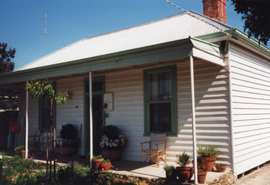
Photograph - Historic House, 1999
Built 1909 for George 'Maori' Jemmeson, member of the Salmon CompanyColour photograph of a timber dwelling at 10 Orme Street. Hipped iron roof, single paned sash window each side of front door, which has fan light above. Veranda of concrete, with steel pipe veranda posts. Lakes Entrance Victoriahouses, heritage study -
 Lakes Entrance Historical Society
Photograph - Old North Arm Bridge, 2000
Date made May 2000Colour photograph showing the activity during the deconstruction of the old North Arm bridge showing cranes lifting handrails, circular saw cutting concrete bridge decking, and top of piers removed. Scene indicates how the bridge was constructed in 1917. Lakes Entrance Victoriabridges, waterways, demolition -
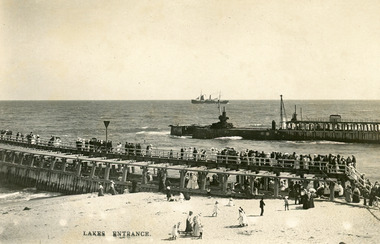 Lakes Entrance Historical Society
Photograph - Entrance Piers, Bulmer and Segerberg, 1910c
Black and white photograph showing piers and entrance to Gippsland Lakes from ocean Bass Strait. Crowd of people on eastern pier and beach. Concrete extension to western pier in progress, two cranes. Steam ship with sails out at sea. Lakes Entrance VictoriaLakes Entrancewaterways, boardwalk, ships and shipping, piers -
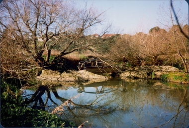
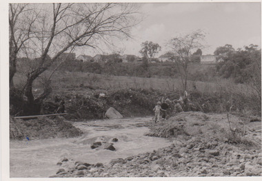 Darebin Parklands Association
Ford in Darebin Creek May 1974, Darebin Parklands Association, 1974
B&W photograph. At place where concrete bridge is now located. This item and all other Darebin Parklands Association archival material is now held by State Library Victoria (Accession No: YMS 13746). Please contact State Library Victoria if access is required.Annotated on back [showing pebbly "beach" now no longer there] -
 Bendigo Historical Society Inc.
Photograph - Kangaroo Flat Gold Mine Collection: Williams United shaft, Western Mining Corporation, Bendigo Office
Black and white photocopy of photo. Image shows square mesh steel fence around perimeter of Williams United shaft, two gates in front to allow entry to shaft area. Concrete pad surrounds shaft area. Ring-lock security fence in background.On back in pencil: Williams United prior to cappingwestern mining corporation, goldmining, capping, shaft, mining regulations, williams united shaft -
 Lakes Entrance Historical Society
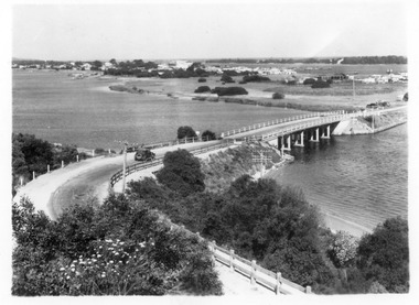
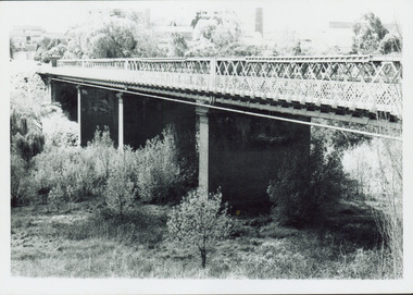
Photograph - North Arm bridge Lakes Entrance Victoria, 1935c
Black and white photograph of view of concrete North Arm Bridge, showing highway to town, Cunninghame Arm, sand hummocks, vegetation, touring car approaching bridge, and three cars parked at town end of bridge, electricity and telegraph poles. Lakes Entrance Victoriatownship, vegetation, transport, bridges -
 Lakes Entrance Historical Society
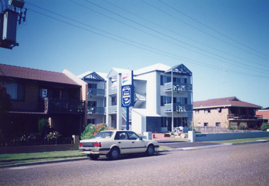
Photograph - Bellevue Apartments, 1992
Apartments opened for 1991 / 1992 seasonColour photograph of Bellevue Apartments, built on Marine Parade. Modern style building, concrete slab construction, each unit having own balcony. Section of Lakeside Motel seen on left, Hybiscus Motel on right. Car on street at front. Lakes Entrance Victoriahotels, architecture, transport -
 Eltham District Historical Society Inc
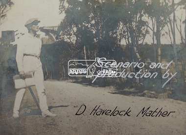
Document - Photograph, Donald Havelock Mather, Papers of Donald Havelock Mather of Kooringarama Films, Oct. 1927
These papers held by the National Library of Australia focus on the film “Borrowed Plumes” shot entirely in Eltham over ten days in October 1927. Some of the location shots are of Main Road near the bridge taken a year after the concrete bridge was opened.borrowed plumes (film), donald havelock mather, eltham, eltham south, kooringoorama films, main road, main road bridge, wingrove park -
 Phillip Island and District Historical Society Inc.
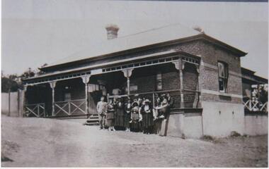
Photograph, Cowes Post Office, Phillip Island, 1920
Post Office on corner of Thompson Avenue and The Esplanade. Brick above concrete building with two brick chimneys. Iron roofing, fenced verandah. Group of 12 people, males suited, with collars and ties, ladies all in long skirts, jackets and hats.Post Office with group of people standing and seated in front of buildingP.O.Cowes (written on back of photograph)local history, photographs, post office, cowes, black & white photograph, ann brown collection, bruce bennett -
 Kew Historical Society Inc
Photograph - Outer Circle Railway Viaduct
The heritage listed Fairfield Bridge was originally constructed for the Outer Circle Railway to bridge the Yarra River between East Kew and Fairfield stations. In the 1930s it was converted for vehicular traffic. In the 2010s a new concrete bridge was erected beside it to increase vehicular capacity.Print copy, enlarged from original snapshot, of the former railway viaduct crossing the Yarra and linking Kew and Fairfield. The original photo predates the conversion of the viaduct into the Chandler Highway Bridge in the 1930s, when the Bridge was adapted to carry vehicular traffic. The date on the reverse indicates the date of donation rather than the date on which the photograph was taken. CHANDLER HIGHWAY BRIDGE OVER RIVER / (ORIGINALLY PART OF OUTER CURCLE RAILWAY) / OCTOBER 1977railway viaduct -- kew (vic.), fairfield bridge, fairfield railway viaduct, outer circle railway, sir john monash -
 Kew Historical Society Inc
Photograph - Chandler Highway Bridge, 1977
The heritage listed Fairfield Bridge was originally constructed for the Outer Circle Railway to bridge the Yarra River between East Kew and Fairfield stations. In the 1930s it was converted for vehicular traffic. In the 2010s a new concrete bridge was erected beside it to increase vehicular capacity.Print copy of the Chandler Highway Bridge, [formerly the Fairfield Viaduct of the Outer Circle Railway] showing the original position of the walkway beside the bridge. The POV is from the Fairfield side looking towards Kew. CHANDLER HWY BRIDGE OVER YARRA / OCTOBER 1977 / ORIGINALLY BUILT FOR OUTER CIRCLE RWYchandler highway bridge, outer circle railway viaduct, bridges -- kew (vic.) -
 Lakes Entrance Historical Society
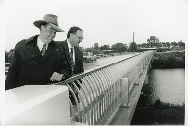
Photograph - Bridges, Lakes Post Newspaper, 1995
The first concrete bridge built over Tambo River at Swan Reach, in 1932 was never officially opened, so the opening of the refurbished bridge on 19 December 1995 was declared 'The Official Opening'. Photo taken at the Official Opening 19 December 1995Black and white photograph showing David Treasure, MLA, and Norm Butler of VicRoads, on the strengthened and widened bridge, over the Tambo River at Swan Reach, Victoria.bridges, waterways, officials -
 Federation University Historical Collection
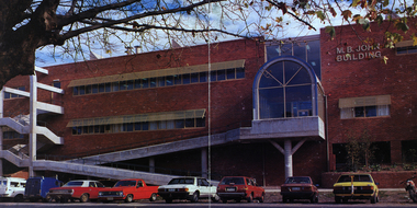
Image - Colour, Ballarat School of Mines M.B. John Building, Albert Street, Ballarat, 1987, 1987
The M.B. John Trade–Art building (Albert Street front) of SMB was officially opened by the Hon. John Cain, Premier of Victoria, in the presence of Morgan B. John. Programs include 3 Dimensional Art, Painting & Decorating, and Engineering Trades. (SMB Institutional Plan 1989) The M.B. John Building (Building K), a three storey, face red brick, restrained Late Twentieth Century International styled building with an elongated, cuboid form (defined by the parapeted facades) that is offset by projecting exposed concrete framed, round‐arched entrance and stair wells on the east (Albert Street) elevation (the centrally located entrance breaking the brick façade with glazing). The facades are also characterised by banks of aluminium framed, horizontal ribbon windows, which wrap around the building corners. Metal shades project beyond the windows, while post‐supported bullnosed verandahs and hoods and projecting concrete stairs are other features. On the west elevation, the cuboid façade is punctuated by projecting curved concrete and glazed, elongated bays at first floor level. (David Rowe/Wendy Jacobs)Image of a multi-storey brick building on the Ballarat School of Mines campus. The building is known as the M.B. John Building.ballarat school of mines, m.b. john building, morgan b. john, albert street, m.b. john -
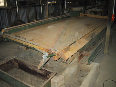 Parks Victoria - Maldon State Battery
Concentrating table
The table was used to separate gold from crushed quartz through vibration movement The Phoenix Foundry, part of James Martin and Company, was established by James Martin, MLC, often referred to as the “Father of Gawler”. The Phoenix Foundry was significant, historically, because it formed part of the leading engineering works in the state in the late nineteenth century when Gawler was one of Australia's most important industrial centres. The company was established in 1848 and ceased operation: in1907 Large Phoenix-Weir concentrating table. Rectangular green and pink painted table, inscription on one side with decorative motives, comprises of slatted table top which creates ridges, wooden channel which is bolted on table top, box with holes in base sitting loosely next to channel, table is joined to gear/s which in turn runs belt wheel, gear/s sits on unpainted concrete block, whole table sits on 2 concrete pillars which are raised, table top is tilted on an angle, wooden trough is on lower side of table and sits underneath which is sitting on rusty tins."the phoenix-weir jas martin & co/concentrating table sole makers/gawler. S.A" -
 Lake Bolac & District Historical Society
Black and white photograph, Lake Bolac Overflow and Weir, circa 1949
Lake Bolac. The concrete weir and water-level adjusted overflow into the man-made channel into Salt Creek on the south side of the lake, circa 1949. The Moreton family is playing in the shallow trickle of water. Malin's windmill and pump can be seen on the bank in the background.lake bolac, salt creek, overflow, moreton, malin, windmill -
 Bendigo Historical Society Inc.
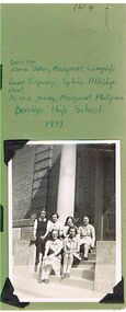
Photograph - BENDIGO HIGH SCHOOL, FORMS 5 AND 6, 1939
Black and white photograph: two rows of girls, sitting on concrete steps outside Bendigo High School. Names written over top of photo. Back row: Elma John, Margaret Campigili, Gwen Tripcony, Sylvia Aldridge. Front: Norma Young, Margaret Philipson.bendigo, education, bendigo high school, elma john, margaret campigili, gwen tripcony, sylvia aldridge. front: norma young, margaret philipson. bendigo high school, bendigo girls school, 1939, education -
 Bendigo Historical Society Inc.
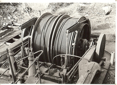
Photograph - WINDING ENGINE AT MONUMENT HILL MINE
Black and white photograph of a winding engine (Roberts & Son) at Monument Hill Mine. Winding gear, large drum with wire cable wound on, sitting on concrete base. Inscriptions: on back - lined paper, glued in centre 'Monument Hill Mine, Winding Engine, Roberts and Sons'.place, mining site, rope winding drum, mines and mining, equipment, mining equipment, bendigo, mines, mining, surface equipment -
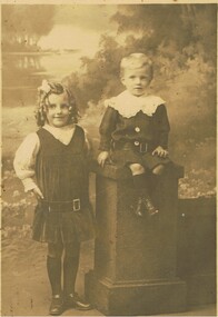 Bendigo Historical Society Inc.
Photograph - PORTRAIT OF 2 CHILDREN
Photograph - black and white - Portrait of 2 children. Young girl standing , wearing a pleated dress with belt, ringlets, side part and a ribbon in hair. Young boy is sitting on a concrete looking pillar, same looking belt, big wide lacy collar, blonde hair.Eden Studios - Melbourne.person, group, children, portrait of 2 children. -
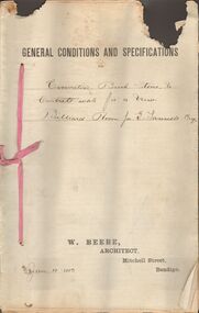 Bendigo Historical Society Inc.
Document - MARKS COLLECTION: EXCAVATING BRICK, STONE CONCRETE WORK BILLIARD ROOM FORTUNA, 12th January, 1893
Document, on top of first page printed General Conditions and specifications' handwritten, for excavating brick, stone and concrete work for a new Billiard Room for G. Lansell Esq' On bottom of page printed : W. Beebe, Architect, Mitchell Street, Bendigo. Dated Jan 12, 1893.W Beebe, Architect, Mitchell Street, Bendigobendigo, buildings, fortuna villa -
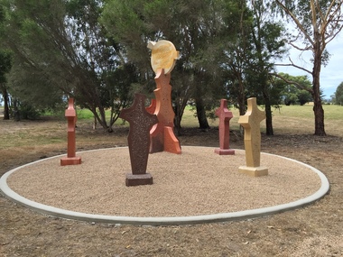 Federation University Art Collection
Sculpture, 'Mungo Moon' by Don Barrett, 2015
'Mungo Moon' by Don Barrett is the first sculpture erected on the Churchill Art and Culture Pathway. It was officially unveiled by Professor David Battersby on 15 April 2015 From Churchill & District News 16 October 2014 The Churchill Art and Culture Walking Pathway will have its official public opening on Saturday October 18, with a walk finishing at Federation University Australia’s Switchback Gallery at the Federation University Gippsland Campus. ... An important link on the newly developed pathway was recently completed with a path south of the FedUni Student West Residences. The path now allows walkers to turn off the Eel Hole Creek path before reaching Glendonald Estate and to follow a picturesque, tree lined walkway to join up with the footpath on the Eastern side of Northways Road. From there the footpath joins into Federation University’s network of walking paths that proceeds past the Switchback Art Gallery, down through the pine plantation and along Lake Kretlow and the Churchill Golf Course. Project Manager Mike Answerth, said the opening of the West Residences section of the path means there is now only one short link to complete. “We’re now very close to realising the project’s objective to join up all these walking paths to provide a continuous pathway that encompasses town, campus and parkland. The next stage of the project will be the completion of Latrobe City’s East West Link and the enhancement of the walking path with artistic and cultural features.” said Mr. Answerth. Head of Federation University Australia Gippsland Campus, Dr Harry Ballis, said the project had been made possible through the contributions of the five former Gippsland Education Precinct (GEP) partners. “The Art and Culture Pathway represents another important step in joining the Churchill township and the university campus as a physical and social entity,” Dr Ballis said. “This was an initiative of the GEP and it is pleasing to see it coming to fruition.” The path now reaches as far as the golf driving range but plans are already under way to connect with the Mathison Park board walk and pathway, which surrounds Lake Hyland in Churchill. When the loop is completed, residents and visitors will have an approximately 5km circular walking path which links up the Churchill town centre, Federation University Australia and Mathison Park. There are already art features along this route, including primary schools’ Bug Blitz totems near the Kurnai College school crossing, native vegetation and history panels near the Hare Homestead in Mathison Park, and outdoor sculptures in the pine trees near the Federation University Switchback Gallery. contemporaryA large sculpture in five pieces set in an external location. It is part of the Churchill Art and Culture Walking Pathway. Don Barrett’s work is mainly in concrete with added coloured oxides to portray the feeling of the Australian landscape. Barrett focuses on concepts of Australia’s short history and indigenous history. churchill art and culture pathway, barrett, don barrett, gippsland campus, federation university, churchill, sculpture -
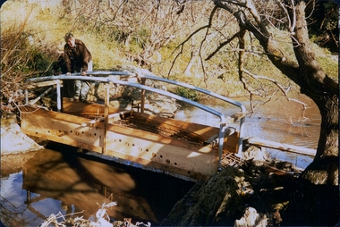
 Darebin Parklands Association
Clifton Bridge, 1979-1980
The bridge was designed and constucted by Sidney Clifton, an engineer who lived in a house neighbouring the parklands.Colour photograph. The wooden frame of the Clifton Bridge which the concrete was poured in to set. This item and all other Darebin Parklands Association archival material is now held by State Library Victoria (Accession No: YMS 13746). Please contact State Library Victoria if access is required. -
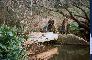
 Darebin Parklands Association
Installing Clifton Bridge, 1979-1980
The bridge was designed and constucted by Sidney Clifton (pictured), an engineer who lived in a house neighbouring the parklands.Colour photograph. The wooden frame and handrails of the bridge are erected ready for the concrete to be poured in. This item and all other Darebin Parklands Association archival material is now held by State Library Victoria (Accession No: YMS 13746). Please contact State Library Victoria if access is required. -
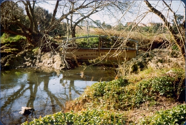
 Darebin Parklands Association
Installing Clifton Bridge, 1979-1980
The bridge was designed and constucted by Sidney Clifton, an engineer who lived in a house neighbouring the parklands.Colour photograph. The wooden frame used to set the concrete section of Clifton Bridge. This item and all other Darebin Parklands Association archival material is now held by State Library Victoria (Accession No: YMS 13746). Please contact State Library Victoria if access is required. -
 Darebin Parklands Association
Clifton Bridge, 1979-1980
The bridge was designed and constucted by Sidney Clifton, an engineer who lived in a house neighbouring the parklands.Colour photograph. The wooden frame of the Clifton Bridge which the concrete was poured in to set. This item and all other Darebin Parklands Association archival material is now held by State Library Victoria (Accession No: YMS 13746). Please contact State Library Victoria if access is required. -
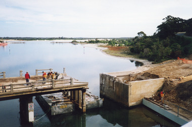
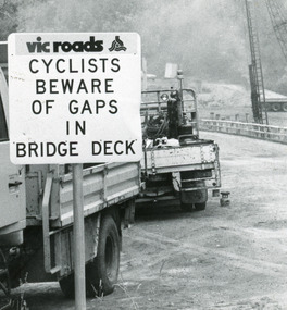 Lakes Entrance Historical Society
Photograph, Lakes Post Newspaper, 1991
Date made January 1991Black and white photograph taken when work commenced on the construction of the new concrete bridge on the Princes Highway, Toorloo Arm, near Lakes Entrance. Road works in distance, crane beside present bridge, Vicroads warning sign to cyclists in foreground. Toorloo Arm Victoriabridges, waterways -
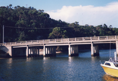 Lakes Entrance Historical Society
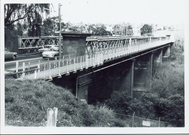
Photograph - North Arm bridge Lakes Entrance Victoria, Davies, Judy, 1999c
Colour photograph of the concrete bridge over the North Arm, taken from the western side, showing part of the northern embankment and four sets of piers. In the background wooded Kalimna Heights with some residences visible. Right foreground is the bow of a small runabout. Lakes Entrance Victoriabridges, boats and boating, topography