Showing 1662 items
matching george hill
-
 Hume City Civic Collection
Photograph, c Early 1990's
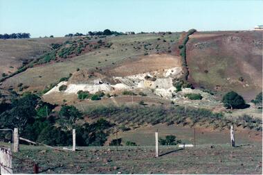
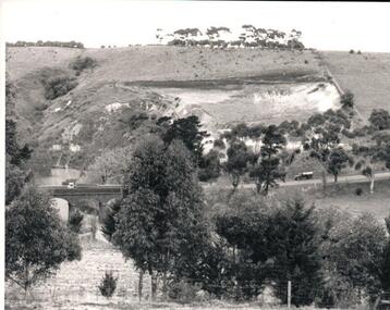
The Kaolin quarries at Bulla were an important industry in the district and supplied clay products to the Cornwell and Hoffman companies in Brunswick. The Kaolin deposits were found in the 1850's and were considered to be some of the largest in the colony.A landscape photograph of a valley with a post and wire fence and a partial view of a farm gate in the immediate foreground. A clump of native trees are on the LHS and a small grove of almond trees has been planted on the river flat. Kaolin quarry is on the hillside and two buildings can be seen on the hill top. High tension pylons are in the distance near the skyline.kaolin quarries, almond groves, bulla township, deep creek, hoffmans kaolin mine, hoffmans potteries, cornwell potteries, george evans collection -
 Hume City Civic Collection
Photograph, c 1980s
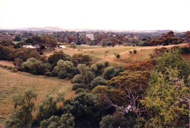
The photograph although recently taken shows the original settled area in Sunbury, which included Goonawarra Vineyard and Macedon Street which was once the business centre of Sunbury township before the railway was established.A coloured photograph of Sunbury Township looking west from above Jacksons Creek and Goonawarra Winery. Macedon Street can be seen in the middle distance and Mt. Holden and Burke Hill are across the skyline.sunbury township, mt. holden, burke hill, francis, james goodall, barnier, john, jacksons creek, goonawarra winery, george evans collection -
 Hume City Civic Collection
Photograph
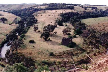
Lochton was owned by William Morris Hunter who built and established the three storey flour mill on the horseshoe bend near Deep Creek in Bulla in the mid 1850s. The mill was steam driven. Since the 1960s when the Boral Company acquired Lochton, the property was leased out until January 1994.A coloured photograph of a former bluestone flour mill on a horseshoe bend of the Deep Creek. Trees are growing along the banks of the creek and sparsely covered hills are along the skyline.flour mills, hunter, william morris, lochton flour mill, deep creek, boral company, george evans collection -
 Hume City Civic Collection
Photograph, c late 1980s
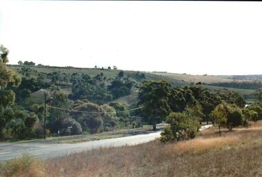
The photograph shows a section of the original settlement of the Bulla township. The cutting on the hillside is significant as it is the remains of one of the original stream crossings in Victoria.A coloured photograph of the Bulla Hill along Sunbury Road with a view of the cutting on the distant hillside. The photograph is a view of the old Bulla township looking to the NW. There is a wide grassy verge in the foreground.bulla township, deep creek, wright, william 'tulip', sunbury road, george evans collection -
 Hume City Civic Collection
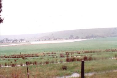
Photograph
The series of photographs were taken after exceptional heavy rain had fallen in Sunbury in the early 1990s. The Jackson Creek overflowed its banks and the surrounding flood plain area was under water.A coloured photograph of the Jackson Creek in flood along a river flat within the Rupertswood Estate. There are bare hills in the background and a fenced off run in the foreground.floods, weather patterns, jacksons creek, george evans collection -
 Hume City Civic Collection
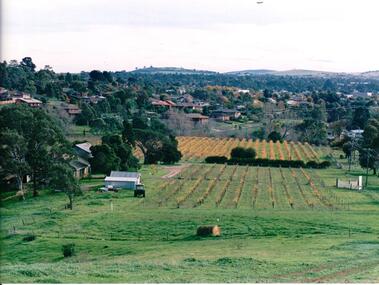
Photograph, late 1980s
'Craiglee' Winery was established by James Stewart Johnstone in 1865 and the property continued to function as a winery until the late 1920s. The vines were uprooted and the property was used for wool and fat lamb production. In 1961 the Carmody family purchased the property and in 1976 re-established the vineyard.A coloured landscape photograph overlooking Craiglee Winery and vineyard as well as the Sunbury township and its surrounding hills north of the town. A roll of hay is in the foreground and a tractor near out buildings is to the LHS of the photograph.wineries, vineyards, johnstone, james stewart, carmody, patrick, 'craiglee' winery, george evans collection -
 Hume City Civic Collection
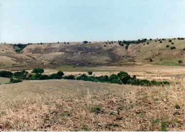
Photograph, c 1990s
Canon Gully is situated about 2 km upstream from the railway bridge at Rupertswood. In 1864 it was the site for the military encampment of the Victorian Volunteer Forces. William Clarke allowed the military to stage the annual event on his property. Further encampments were held on this site in 1874 and 1877.A coloured photograph of a wide valley with cleared hills in the background. The tree lined creek or watercourse is across the middle distance of the image.canon gully, rupertswood estate, encampments, clarke, william j. t. 'big bull', victorian volunteer forces, george evans collection -
 Hume City Civic Collection
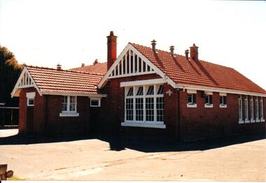
Photograph, early 1990s
The brick building was constructed in 1911/1912 and replaced an earlier school building. In 1942/43 the school building was extended to cope with the increased population in Sunbury. The State School remained on the Macedon Street site until 1999 when it was relocated to the restored former Industrial School at Jacksons Hill.A coloured photograph of the former Sunbury State School No. 1002. It is a red brick Federation building with a red terracotta tiled roof and wooden white painted trims. There are two stepped brick chimneys with terracotta chimney pots and six air vents protruding from the roof. There is a small porch at the front of the building.carirns, j. f. dr., eadie, peter, education department, george evans collection -
 Hume City Civic Collection
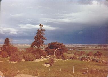
Photograph, September 1994
Woodlands Park complex which includes 'Cumberland' and 'Dundonald' ruins and the Gellibrand Hill Quarries was acquired by the Victorian State Government in 1978 and is managed by Parks Victoria.A view taken from Gellibrand Hill looking east towards the developing suburb of Greenvale. There are small rocky outcrops in the foreground and a clump of conifers and cypress trees in the middle. The sky is very overcast and a range of mountains can be seen across the skyline. Coloured photograph with rounded corners and matt finish.woodlands park, gellibrand hill, greene, william pomeroy, anne, george evans collection -
 Hume City Civic Collection
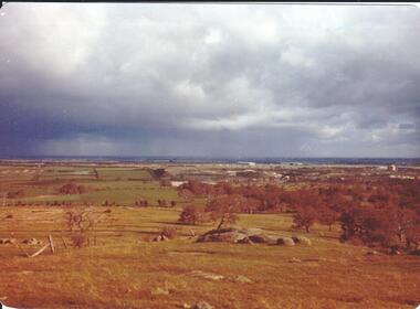
Photograph, September 1994
Woodlands Park complex which includes 'Cumberland' and 'Dundonald' ruins and the Gellibrand Hill Quarries was acquired by the Victorian State Government in 1978 and is managed by Parks Victoria.A view looking west towards the outer limits of the Tullamarine Airport taken from Gellibrand Hill. There is a small rocky outcrop in the middle of the photograph and trees are on the RHS of the image. Coloured photograph with rounded corners and matt finish.woodlands park, gellibrand hill, greene, william pomeroy, anne, george evans collection -
 Hume City Civic Collection
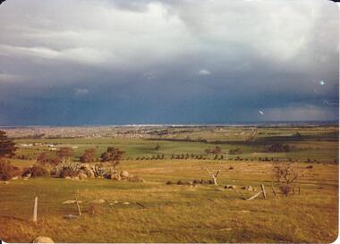
Photograph, September 1994
Woodlands Park complex which includes 'Cumberland' and 'Dundonald' ruins and the Gellibrand Hill Quarries was acquired by the Victorian State Government in 1978 and is managed by Parks Victoria.A view taken from Gellibrand Hill looking east towards the expanding suburb of Broadmeadows. Apart from a few rocky outcrops and small trees the open grassland slopes away to a small line of conifers. Coloured photograph with rounded corners and matt finish.woodlands park, gellibrand hill, greene, william pomeroy, anne, george evans collection -
 Hume City Civic Collection
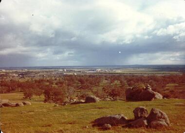
Photograph, Sep-94
Woodlands Park complex which includes 'Cumberland' and 'Dundonald' ruins and the Gellibrand Hill Quarries was acquired by the Victorian State Government in 1978 and is managed by Parks Victoria.A view taken from Gellibrand Hill looking towards the recently constructed Tullamarine (Melbourne) Airport. The airport buildings are just beyond an outcrop of trees. Four rocky outcrops are spread around the foreground. Coloured photograph with rounded corners and matt finish.woodlands park, gellibrand hill, greene, william pomeroy, anne, george evans collection -
 Hume City Civic Collection
Photograph, Sep-94
Woodlands Park complex which includes 'Cumberland' and 'Dundonald' ruins and the Gellibrand Hill Quarries was acquired by the Victorian State Government in 1978 and is managed by Parks Victoria.A view taken from Gellibrand Hill looking northwest. The open grassed area in the foreground is dotted with a number of rocky outcrops with conifers and cypress trees in the background. There are a few buildings in the distance.Coloured photograph with rounded corners and matt finish.woodlands park, gellibrand hill, greene, william pomeroy, anne, george evans collection -
 Hume City Civic Collection
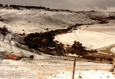
Photograph, 1/08/1986
A series of photographs were taken when heavy snow fell in Sunbury in August 1986. The snow began falling overnight and remained on the ground for 24 hours. Snow fell across the metropolitan area during that 24 hour period in a very unusual event for the area.A coloured photograph of the valley overlooking the Sunbury Sewerage farm and Eadie Hill after snow had fallen.snow falls, weather patterns, winter, sunbury sewerage farm, george evans collection -
 Hume City Civic Collection
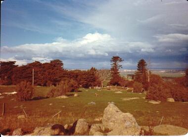
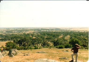
Photograph, 1980s
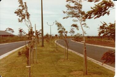
... bald hill sunbury george evans collection A landscape coloured ...The photograph was taken above Reservoir Road on the lower slopes of Mt. Holden. It is looking south down Wilson's Lane towards some of the early Sunbury developments which grew around the Gap Road area in the early 1980s.A landscape coloured photograph with rounded corners. It is a panoramic view of Sunbury taken from the southern slopes of Mt. Holden. In the foreground there is a small cluster of trees and in the middle distance there is some evidence of housing development. Bald Hill can be seen on the skyline.wilson's lane, mt. holden, bald hill, sunbury, george evans collection -
 Hume City Civic Collection
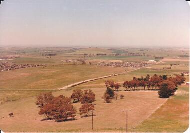
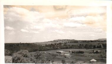
Photograph, early 1980s
The photograph shows the extent of Sunbury's development to the west of the town in the early 1980s. The settlement at this stage extended along either side of Gap Road for about 0.5 km beyond Elizabeth Drive.A coloured landscape photograph with rounded corners taken from Mt. Holden and looking towards the expanding town of Sunbury. The Melba Avenue drain which flows into Blind Creek is in the foreground. Sheoak Hill, the site of the former Sunbury Asylum is in the middle of the skyline.sunbury township, reservoir road, mt. holden, sunbury asylum, george evans collection -
 Hume City Civic Collection
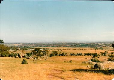
Photograph, early 1980s
The Tullamarine Airport opened in 1970 and replaced Essendon Airport as Melbourne's main airport terminal. Gellibrand Hill was incorporated with Woodlands Park and became a public reserve during the 1980s.A coloured landscape photograph with rounded corners taken from Gellibrand Hill and overlooking the Tullamarine Airport which is on the RHS of the photograph. The Melbourne City skyline can be seen in the distance.gellibrand hill, tullamarine airport, melbourne skyline, george evans collection -
 Hume City Civic Collection
Photograph, early 1980s
... hill tullamarine airport george evans collection A coloured ...Gellibrand Hill along with the surrounding 3 properties: Attwood, Cumberland and Woodlands were incorporated into Gellibrand Park during the 1980s. Tullamarine became Melbourne's main air terminal in 1970 and replaced Essendon Airport.A coloured landscape photograph with rounded corners of the Tullamarine Airport taken from Gellibrand Hill. A man with his back to the camera is on the RHS and another person is running down the hill on the LHS. The area in the middle distance is lightly treed and the airport is in the distance to the right of the photograph.gellibrand hill, tullamarine airport, george evans collection -
 Hume City Civic Collection
Photograph
A black and white photograph of a farm buildings at Rupertswood with Jackson Creek in the near background and the Caloola Training Centre on the hill in the background.sunbury asylum, rupertswood, farming, clarke, william (sir), farmbuildings, salesian order, caloola training centre, george evans collection -
 Hume City Civic Collection
Photograph, Early 1970s
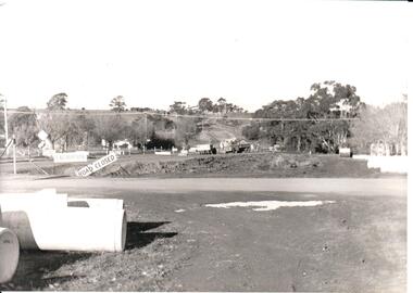
The two arch bluestone bridge which spanned the Jacksons Creek was replaced in the early 1970s with a wider double lane bridge. Dangerous curves were also taken out of the road. The area in the foreground on the RHS has now been incorporated into a public picnic area.A black and white photograph of road works taking place on the Sunbury Road over Jacksons Creek. Large concrete drain pipes are in the foreground and on the RHS of the photograph with roadwork signs on the LHS. Three trucks are at the foot of the hill.macedon street, macedon street road bridge, jacksons creek, road construction, george evans collection -
 Hume City Civic Collection
Photograph, c 1907
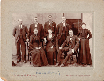
This came as part of a large collection of photos from Eric Boardman. Originally catalogued by R Waters on 12.02.1988. There are 3 copies of the original in black & white 20.5 cm x 25.5 cm format. According to information in the supplementary file from Bob Cahill who is the grandson of JF Cahill and son of Malachi Cahill, the identification of the photo is as follows: L to R (standing): James, John Francis (father), John, Malachi; L to R (seated): Mary / Margaret nee Ryan (mother), Polly (Mary), Michael (Mick) and ? (not specified) Margaret. NB/ Nora (Annie) who ran the Ball Court Hotel is missing from the photo. Other details: John Francis Cahill was a blacksmith & bootmaker and thought to be English; he married Mary or Margaret Ryan prior to coming to Sunbury. He built the Ball Court Hotel in 1854. (See 'Bulla Bulla'.) Nora (Annie) married a McGrath; Margaret married a Breen; James did not marry; Mary (Polly) married Justin Ford, Shire President in 1917. Malachi (born in 1878) married Mary Jane English. She was aged forty at the time of marriage & was originally from Ballarat. She worked at 'The Hill'. Malachi was a railway worker & died travelling on a train. There is also information about the Bulla Cahill family in the supplementary file.Mounted black & white photograph of the family of John Francis Cahill. It portrays 5 males and 3 females seated formally in front of a building. The photo is in sepia tonings mounted on a grey mount."Cahill Family" written in blue biro on the centre front of the mount below the photo; "Eric Boardman" handwritten in red pencil on the back of the mount.pioneers, cahill family, cahill, john francis, mary, ryan, john, malachi, polly, michael, ball court hotel, boardman, eric, ford, justin, matson & frazer, george evans collection -
 Hume City Civic Collection
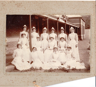
Photograph
Mounted b/w photograph, with lower portion of mount cut off, of nurses at 'the Hill'.nurses, occupations, sunbury hospital for the insane, george evans collection -
 Hume City Civic Collection
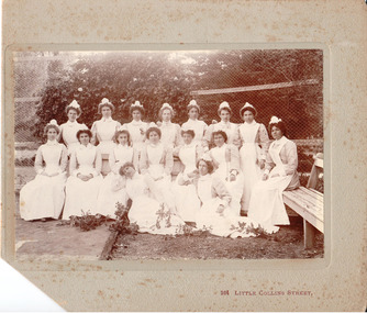
Photograph
The nurses would have been employed at the Sunbury Asylum, which functioned for 120 years until in closed in 1992. The entire complex is now a housing estate, known as Jacksons Hill.Sunbury Asylum like other similar institutions were establish in outer rural areas or regional towns across the state. Mounted b/w photograph with corner of the mount cut off, of nurses. There is some damage from mould across the photograph and the cardboard mounting.264 Little Collins Streetnurses, occupations, sunbury hospital for the insane, george evans collection -
 Hume City Civic Collection
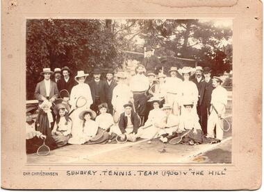
Photograph, 1906
... photographers gilchrist harker street sunbury hill team 1900s george ...Mounted sepia photograph of the Sunbury Tennis Team and the Hill Team taken 1906.Printed on front: Chris Christiansen|Handprinted on front: Sunbury Tennis Team (1906) V The Hill Handwritten on back: Gilchrist Harker Street, Sunburysunbury tennis team, tennis, sports, chris christiansen, photographers, gilchrist, harker street, sunbury, hill team, 1900s, george evans collection -
 Hume City Civic Collection
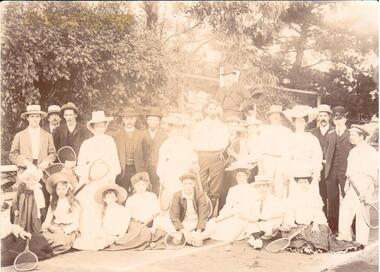
Photograph
... melbourne sports tennis boardman eric the hill sunbury asylum george ...A sepia photograph of a group of unidentified tennis players at The Hill. See also #176.Handwritten on back: TENNIS AT THE HILL / ERIC BOARDMANsports, tennis, boardman, eric, the hill, sunbury asylum, george evans collection -
 Hume City Civic Collection
Photograph, 1/11/1980
On 4th August 1978 the construction of the Goonawarra Housing Estate commenced. The estate was formerly known as the Goonawarra Farm and overloked the Sunbury town area and Jacksons Creek valley. Plans for the new development included a gold course, housing, community and recreational facilities. The construction continued througout the last two decades of the twentieth century and into the twenty first century.A coloured photograph of Francis Boulevard at the Goonawarra Estate showing the entrances and landscaping and looking south to Sunbury Road and Jacksons Hill (Sheoak Hill).goonawarra farm, goonawarra golf club, goonawarra housing estate, kilkenny homes, craftsmen homes., australian ideas homes pty.ltd., villa bella homes, glamor homes, george evans collection -
 Hume City Civic Collection
Photograph, Early 1970s
The Kaolin Quarry at Bulla supplied Kaolin to the Northcote and Brunswick Pottery Works until it ceased operation at that site in the 1950s. The three arched bluestone bridge r3placed a ford crossing across Deep Creek, which along with Jacksons Creek flows into the Maribyrnong River.A black and white photograph of the Deep Creek and three arched bluestone bridge in the Bulla Township with the Kaolin Quarry in the background. One truck is crossing the bridge with a tanker approaching the bridge at the bottom of the Bulla Hill.deep creek, bridges, kaolin quarries, quarries, george evans collection -
 Hume City Civic Collection
Book, Adair's Excelsoir Copy Book
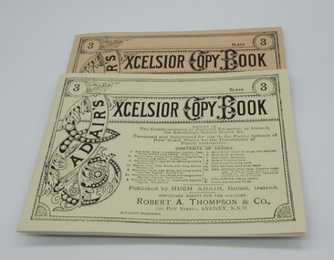
... Historical Park Association, Sovereign Hill Goldmining Township ...This is a facsimile reproduction published by the Ballarat Historical Park Association, Sovereign Hill Goldmining Township, Ballarat, Victoria 3350, for the use in the Red Hill National School, Sovereign Hill.A cream coloured book with black lettering on the cover. Pages ruled out for copying handwriting.adair, hugh, schools, teaching, nsw department of public education, sovereign hill gold mining township., george evans collection -
 Hume City Civic Collection
Book, Elementary Drawing Copy Book
... , Sovereign Hill Goldmining Township for use at the Red Hill National ...This is a facsimile of a drawing copy book compiled by an art teacher in london in 1864 and copied by the Ballarat Times, Sovereign Hill Goldmining Township for use at the Red Hill National School.A tan coloured cover with pages set out to enable students to copy different drawings printed at the top of the pages.teaching, primary school, sovereign hill goldmining township, george evans collection -
 Hume City Civic Collection
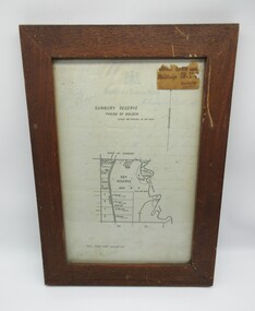
Plans, SUNBURY RESERVE PARISH OF HOLDEN
... adjacent to the Asylum boundary, now Jacksons Hill. sunbury sunbury ...This object is a plan of a proposed recreation ground at Munro's. This was unfenced land between Evans and Barkly Streets adjacent to the Asylum boundary, now Jacksons Hill.A wooden framed plan of a proposed recreation ground.sunbury, sunbury asylum, george evans collection