Showing 1911 items matching "taylor's"
-
 Federation University Art Collection
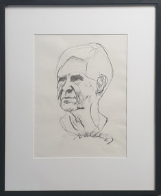
Drawing - Charcoal on paper, Wes Walters, 'Study for Portrait of Arthur Boyd' by Wes Walters, 1982, 1982
Wes WALTERS (06 August 1928 - 19 August 2014) Born Mildura, Victoria From 1940 t0 1945 Wes Walters attended the Ballarat High School. He then studied architecture at the Gordon Institute in Geelong, followed by art at the Ballarat School of Mines (a division of the Ballarat School of Mines). During his time at the Ballarat Technical Art School (later Federation University Australia) Walters studied under Neville Bunning and Taylor Kelloch, and was awarded the Ballarat Ladies Art Association Scholarship in 1948. He next moved to Melbourne to work as a commercial artist with the George Patterson advertising agency. Each evening Walters studied life drawing at the Victoria Artists’ Society and taught himself anatomy. Wes Walters excelled in both abstract and realist art. He won the Art Gallery of Ballarat’s Minnie Crouch Prize for watercolour art in 1953 and 1956. He won the prestigious Archibald Prize in 1879 for his portrait of Phillip Adams, and the sketch was completed tin preparation for that portrait. This item is part of the Federation University Art Collection. The Art Collection features over 1000 works and was listed as a 'Ballarat Treasure' in 2007.Charcoal portrait study of Arthur Boyd on Fabriano paper. This sketch is one of several head studies made for the portrait of Arthur Boyd portrait entered into the 1982 Archibald Prize. The painting is in the collection of the Art Gallery of New South Wales. Signed lower right: 'Walters'art, artwork, walters, wes walters, arthur boyd, portrait, available, archibald prize -
 Federation University Art Collection
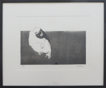
Print - Etching, Wes Walters, 'Chimpanzee' by Wes Walters, 2008
Wes WALTERS (06 August 1928 - 19 August 2014) Born Mildura, Victoria From 1940 t0 1945 Wes Walters attended the Ballarat High School. He then studied architecture at the Gordon Institute in Geelong, followed by art at the Ballarat School of Mines (a division of the Ballarat School of Mines). During his time at the Ballarat Technical Art School (later Federation University Australia) Walters studied under Neville Bunning and Taylor Kelloch, and was awarded the Ballarat Ladies Art Association Scholarship in 1948. He next moved to Melbourne to work as a commercial artist with the George Patterson advertising agency. Each evening Walters studied life drawing at the Victoria Artists’ Society and taught himself anatomy. Wes Walters excelled in both abstract and realist art. He won the Art Gallery of Ballarat’s Minnie Crouch Prize for watercolour art in 1953 and 1956. He won the prestigious Archibald Prize in 1879 for his portrait of Phillip Adams. This item is part of the Federation University Art Collection. The Art Collection features over 1000 works and was listed as a 'Ballarat Treasure' in 2007.Framed limited edition edition depicting a chimpanzee. Donated through the Australian Government's Cultural Gifts Program. Photograph: HStudioart, artwork, walters, wes walters, chimpanzee, animals, available -
 Federation University Art Collection
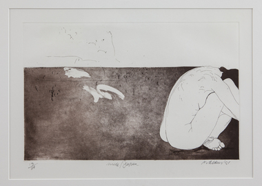
Print - Etching, Wes Walters, 'Nude/Japan' by Wes Walters, 2008
Wes WALTERS (06 August 1928 - 19 August 2014) Born Mildura, Victoria From 1940 t0 1945 Wes Walters attended the Ballarat High School. He then studied architecture at the Gordon Institute in Geelong, followed by art at the Ballarat School of Mines (a division of the Ballarat School of Mines). During his time at the Ballarat Technical Art School (later Federation University Australia) Walters studied under Neville Bunning and Taylor Kelloch, and was awarded the Ballarat Ladies Art Association Scholarship in 1948. He next moved to Melbourne to work as a commercial artist with the George Patterson advertising agency. Each evening Walters studied life drawing at the Victoria Artists’ Society and taught himself anatomy. Wes Walters excelled in both abstract and realist art. He won the Art Gallery of Ballarat’s Minnie Crouch Prize for watercolour art in 1953 and 1956. He won the prestigious Archibald Prize in 1879 for his portrait of Phillip Adams. This item is part of the Federation University Art Collection. The Art Collection features over 1000 works and was listed as a 'Ballarat Treasure' in 2007.Framed limited edition print. art, artwork, wes walters, walters, etching, printmaking etching, edition, alumni, alumnus, aavailable -
 Vision Australia
Audio - Sound recording, Vasmac 2007: Vision Australia School Music Award ceremony, 13/12/2007
Vision Australia School Award ceremony songs: 1. Vision Australia School Song performed on piano by Maritah Suki. 2. Kookaburra sits in the old gumtree sung by the Junior School. 3. Let the good times roll (a Capella) sung by the Middle School. 4. Scooby Doo (a Capella) sung by the Middle School. 5. Knock Knock sung by the Senior School. 6. G'Day sung by the Senior School. 7. Hound Dog sung by the James and Nathan. 8. Everybody loves Saturday night sung by the Transition Group. 9. The Natural Way sung by the Junior School. 10. Let's Go To the Zoo sung by the Junior School. 11. Feels so good sung by Jade Sanderson. 12. Seasons of the year sung by Jade Sanderson. 13. What a Wonderful World performed by Taylor Clay and Matthew Whibley. 14. Please Don't Go performed by Joseph Samarani, Maritah Suki and Jade Sanderson. 15. Sad, Sweet Dreamer performed by Maritah Suki. 16. Sing and Scat performed by the Song Choir, with Brody Grant-Carter on Marimba. 17. Life is a Song by John Foreman. 17 songs from the Vision Australia School Music Award Ceremony 2007vision australia, burwood school, maritah suki, jade sanderson, taylor clay, matthew whibley, joseph samarani, brody grant-carter, john foreman -
![Artwork - Printmaking, [Life Study] by Wes Walters, c1980](/media/collectors/530576742162ef0fa09a2288/items/5d3e913321ea6716b0929ea3/item-media/5dedb84c21ea6706a0c3176b/item-fit-380x285.jpg) Federation University Art Collection
Federation University Art CollectionArtwork - Printmaking, [Life Study] by Wes Walters, c1980
Wes WALTERS (06 August 1928 - 19 August 2014) Born Mildura, Victoria From 1940 t0 1945 Wes Walters attended the Ballarat High School. He then studied architecture at the Gordon Institute in Geelong, followed by art at the Ballarat School of Mines (a division of the Ballarat School of Mines). During his time at the Ballarat Technical Art School (later Federation University Australia) Walters studied under Neville Bunning and Taylor Kelloch, and was awarded the Ballarat Ladies Art Association Scholarship in 1948. He next moved to Melbourne to work as a commercial artist with the George Patterson advertising agency. Each evening Walters studied life drawing at the Victoria Artists’ Society and taught himself anatomy. Wes Walters excelled in both abstract and realist art. He won the Art Gallery of Ballarat’s Minnie Crouch Prize for watercolour art in 1953 and 1956. He won the prestigious Archibald Prize in 1879 for his portrait of Phillip Adams. This item is part of the Federation University Art Collection. The Art Collection features over 1000 works and was listed as a 'Ballarat Treasure' in 2007.Framed etching showing a nude model lying on drapery.A/P Signed 'Walters,wes walters, printmaking, available, nude, lifedrawing -
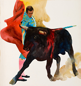 Federation University Art Collection
Artwork, 'Matador' by Wes Walters, c1970s
Wes WALTERS (06 August 1928 - 19 August 2014) Born Mildura, Victoria From 1940 t0 1945 Wes Walters attended the Ballarat High School. He then studied architecture at the Gordon Institute in Geelong, followed by art at the Ballarat School of Mines (a division of the Ballarat School of Mines). During his time at the Ballarat Technical Art School (later Federation University Australia) Walters studied under Neville Bunning and Taylor Kelloch, and was awarded the Ballarat Ladies Art Association Scholarship in 1948. He next moved to Melbourne to work as a commercial artist with the George Patterson advertising agency. Each evening Walters studied life drawing at the Victoria Artists’ Society and taught himself anatomy. Wes Walters excelled in both abstract and realist art. He won the Art Gallery of Ballarat’s Minnie Crouch Prize for watercolour art in 1953 and 1956. He won the prestigious Archibald Prize in 1879 for his portrait of Phillip Adams. This item is part of the Federation University Art Collection. The Art Collection features over 1000 works and was listed as a 'Ballarat Treasure' in 2007.Framed watercolour behind glass showing a matador and a bull. wes walters, bull, matador, available, bullfighting, spanish -
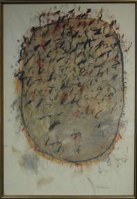 Federation University Art Collection
Drawing - Artwork, Wes Walters, [Untitled] by Wes Walters, 1998
Wes WALTERS (06 August 1928 - 19 August 2014) Born Mildura, Victoria From 1940 to 1945 Wes Walters attended the Ballarat High School. He then studied architecture at the Gordon Institute in Geelong, followed by art at the Ballarat School of Mines (a division of the Ballarat School of Mines). During his time at the Ballarat Technical Art School (later Federation University Australia) Walters studied under Neville Bunning and Taylor Kellock, and was awarded the Ballarat Ladies Art Association Scholarship in 1948. He next moved to Melbourne to work as a commercial artist with the George Patterson advertising agency. Each evening Walters studied life drawing at the Victoria Artists’ Society and taught himself anatomy. Wes Walters excelled in both abstract and realist art. He won the Art Gallery of Ballarat’s Minnie Crouch Prize for watercolour art in 1953 and 1956. He won the prestigious Archibald Prize in 1879 for his portrait of Phillip Adams. This item is part of the Federation University Art Collection. The Art Collection features over 1000 works and was listed as a 'Ballarat Treasure' in 2007.Framed artwork behind glass.wes walters, pastel, abstract, landscape, available -
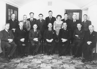
 4th/19th Prince of Wales's Light Horse Regiment Unit History Room
Domestic object - Silver Goblets
Set of 61 silver port goblets, straight bowl design, 38 nominally engravedJ Purcell R Veale J O'Connor J Shepherd A McNeilage C O'Dell P Lucas C Robinson P Fernleigh R Hermon C Brown D Castelow D Rivers A Jones A Krucers G K Smith J Alexander D Crane N Hunter J O'Reilly D Holloway J Leicester D Taylor D Nicholas F Lewis P Martin D Jones M Phillips J McFarlane D McAnintey A Filer L Evans S Gallagher M Stevenson P Wella C Stoylesmess silver, port goblet -
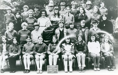 Ringwood and District Historical Society
Photograph, Ringwood State School - Grade 6B, 1973
Black and white photograph - Grade 6B, 1973."Attached to photograph" Back Row- L to R: ?, Craig Lucas, ?, Leslie Weller, ?, ?, Gary Love, Gavin Alexander 2nd Row- L to R: ?, Deidre Taylor, Gaye Bacon, Roslyn Conlan, Terasa Taggart, Marina McNeil, Fiona Weeks. 3rd Row- L to R: Peter Stortenbeker, ?, Cal Harris, Colin McCord, Lyal Tan, Stephen Graham, Jeffrey James, John O'Sullivan. Front Row- L to R: Elizabeth Cuzens, Vicki Jacobs, Julie Griffith, Jenny Walters, Kim Pope, Rhonda Henry, Cathy Withers, ?, Ruth Beattie. Teacher: Mrs J.Parks. -
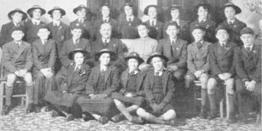 Ringwood and District Historical Society
Newspaper - Newspaper Clipping, Winnington Grammar, Ringwood, School Group on Goodwill trip to Tasmania, Ringwood Mail 20/8/1953 (Photo and News item)
Photo and newspaper clipping from Ringwood Mail, 20/8/1953The Ringwood Mail Newspaper article lists the following names: Back Row :- L. Bryant, F. Walker, J. Carruthers, N. New stead, F. Mark, V. Faudell, M. Homfray, A. Gluth, C. Taylor, P. Cockran . Centre Row:- G. Shultz, A. Hauser, D. Baker, Mr. Stiebel, Mrs. Stiebel, D. Parson, A. Watson, D. Eales, J. Carruthers. Front Row :- E. Sell, P. Newstead, M. Palfreyman, J. Palfreyman. Photo by Ivor Kershaw, Heathmont Written on back of clipping, "'Mail 20/8/53' - Group Winnington to Tasmania". -
Clunes Museum
Photograph
Clunes defeated Ballan in the newly established Central Highlands League (CHFL)Photocopy of colour photograph. Central Highlands League Clunes Football Club 1st XXIII - Premiers 1978Back Row: J Featherston, D Coon, R Hill, L Hughes, B Holland, B Troned, M Vorbach, A Leishman, H Muller, G Keirce Middle: J Hind, L Ingram, L Steart (Trees) D Bartlett,(Pres) R Fraser (Coach, A Van Berkel (Sec.) Front Row: M Watherson, P Tennant, T HIll, (V.C.) L Lyttle (Capt) G Stranger (D.V.C.), L Tucker, L Lubeek, Absent: P Sewell, S Stear, J Taylor, L Thomas, K Kinnersley, J Walker clunes football club, 1978, chfl -
 Wodonga & District Historical Society Inc
Photograph - Fred Rochow Railways Collection - Driver George Padgett's Retirement 1955
The Fred Rochow Railways Collection incorporates photos related to the operation of the Wodonga Railway Station including different types of trains and railways staff C. 1930 – 1990. It was donated to the Wodonga Historical Society by Fred Rochow, a railwayman who spent many years based in Wodonga. He joined the Victorian Railways on 17th June l947 and retired in 1988. For some time, he was a member of the Australian Federated Union of Locomotive Enginemen and served a term as a member of the Trades Hall Council. He had an extensive knowledge of the struggles that took place to achieve better conditions for railway workers. Fred worked for many years as a fireman and then worked his way up the ranks to driver, experiencing many changes from the days of steam locomotives through to diesel trains, locomotives and even the modern XPT train. He worked throughout Victoria at different stages of his career, with his final working years focused on the northeast of Victoria and the Albury to Melbourne line. After his retirement, Fred continued to share his love of steam miniature trains with the community. George Padgett was born into a railway family in Numurkah, Victoria on 3 February 1890. He began working for the Victorian Railways as a junior clerk in Maryborough and gained his Driver’s ticket in 1913 at North Melbourne. In November 1937 when the “Spirit of Progress” made its first run from Melbourne to Albury, he was moved to Wodonga. From the train's first return trip he took over the driving. During his career, he made an average of 92 round trips a year. George made his last trip on 4 February 1955 prior to his retirement. George died in Wodonga on 19 February 1967. This collection has local and statewide significance as it captures images of trains, locomotives and personnel who operated the railway services in Wodonga and throughout Northeast Victoria. The railways played a critical role in opening up Victoria and connecting Australia for trade, business, social communication and transport.A group of men gathered at a retirement function for George Padgett in 1955. George was a driver on the "Spirit of Progress". Back Row: Cyril Hughes, Steve Cuper, Ted Hamilton, Lloyd Holmes, George Lloyd, Frank Fulford, Tom Guinane (?), Mick Kowalzuk (?) Centre Row: Bill Welsh, Eric Molloy, Tom Fitzgerald, Reg Feitz (?), Unknown, George Taylor, Bill Baldock, Reg Matthews, Ted Jenkins, Buddy Straghan(?), Unknown. Seated Front Row: Vic Jones, Vin Snow, Jack Dawe. George Padgett, Alex Reid, ? Lawson, Unknown, Austin Fulford, Doug West, Wally Riley, Norm Davey, Unknown, Wally McGeachin (Clerk), Morrie Flanigan.railways wodonga, fred rochow, k class locomotives -
 Ringwood and District Historical Society
Photograph, Ringwood Councillors and Staff - 1948/49
Black and white photograph (2 copies)Typed on rear of backing sheet: "Ringwood Councillors and Staff - 1949. Front row L-R. Mr. A.F.B. Long (Town Clerk) Cr. F. Corr, Cr. B. Hubbard, Cr. H.C. Pearson (Mayor), Cr. E. Stewart, Cr. H.E. Parker, Cr. W. Wademan. Back Row - J. Proudley (Caretaker), L.C. Steeth (Ranger), S.R. Taylor (Health Inspector), G. Holloway (Clerk), A.C. Robertson (Eng. Asst.), Miss A. Goldie (Typist), C. Cox (Cadet Eng.), C. Merry (Building Inspector), F.R. Lucas (Engineer)" -
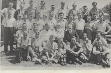
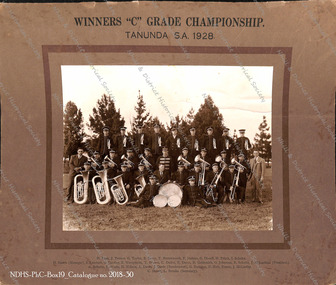 Nhill & District Historical Society Inc.
Photograph - Photograph of Nhill Brass Band, 1928 Tanunda S.A. "C' Grade Band Competition winners, 25 October 1928
This was the first-time winning the "C" grade band competition at Tanunda, S.A. as well as representing Victoria in that competition.There were five new bands participating in the Tanunda, South Australia Band Competition in October 1928, and the Nhill Brass Band under the direction of Mr. James Davis had the honor of representing Victoria. The band participated in the competition despite there being an influenza epidemic before they left. This was the first-time winning the "C" grade competition at Tanunda,S.A. as well as representing Victoria in that competition.Photograph attached to the center of brown colored picture card, with border, title and names inscribed. Pictured are 29 members of the Nhill Brass Band with instruments, plus their manager far left and President far right, in 1928 the year the band won the "C" Grade Tanunda S.A. Band Competition.WINNERS "C" GRADE CHAMPIONSHIP. TANUNDA S.A. 1928 D. Kent, J. Turner, G. Taylor, S. Perry, T. Butterworth, F. Jenkins, G. Diwell, H. Fritch, I. Schultz. H. Harris (Manager), S. Lambert, G. Eardley, E. Westphalin, T. Brown, C. Dalitz, E. Davis, R. Goldworthy, G. Johnston, R. Schultz, J. McLachlan (President). A. Schultz, L. Wade, H. Wilson, A. Davis (Bandmaster), G. Bourdon, N. Holt, Fraser, J. McCarthy. C. Storer, L. Brooks (Secretary).nhill brass band, band competition - south australia, nhill - competition - winners - music - band, d. kent, j. turner, g. taylor, s. perry, t. butterworth, f. jenkins, g. diwell, h. fritch, i. schultz., h. harris (manager), s. lambert, g. eardley, e. westphalin, t. brown, c. dalitz, e. davis, r. goldworthy, g. johnston, r. schultz, j. mclachlan (president)., a. schultz, l. wade, h. wilson, a. davis (bandmaster), g. bourdon, n. holt, fraser, j. mccarthy., c. storer, l. brooks (secretary). -
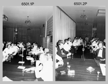 Bendigo Military Museum
Photograph - 4th Field Survey Squadron Formal Dinner, Keswick Barracks, Adelaide SA, 1986
This is a set of 35 photographs of a 4th Field Survey Squadron Officers, Warrant Officers and Sergeants Formal Dinner held at Keswick Barracks, Adelaide SA in 1986. On this occasion WO1 Alex ‘Darby’ Munro and WO1 Geoff Briggs were farewelled. WO1 Munro retired from the Australian Regular Army after 30 years of service. WO1 Geoff Briggs continued his service and retired in 1991. It is apparent there were visiting personnel from the Army Survey Regiment and other unidentified units. See item 6500.11P for colour photos taken at the dinner.This is a set of 35 photographs of a 4th Field Survey Squadron Officer, Warrant Officer and Sergeant’s Formal Dinner held at Keswick Barracks, Adelaide SA in 1986. The black & white photographs are on 35mm negative film and are part of the Army Survey Regiment’s Collection. The photographs were scanned at 96 dpi. .1) - Photo, black & white, 1986. Closest to camera on left: Stevo Hinic, unidentified, Malcolm Hentschel, remainder unidentified. On right L to R: Bob Norwood, Phil Smalley, Bob Mills, unidentified, Bob Garritty, Ian Rose. .2) - Photo, black & white, 1986. On left L to R: unidentified (x2), Tony Gee, Brett ‘Dutchy’ Van Leeuwen, Gary Warnest, remainder unidentified. On right L to R: Barry Lutwyche OAM, Neil Jones, Bob Dikkenberg. .3) - Photo, black & white, 1986. Stewards relax at the bar after dinner. Simon Reynolds 2nd from right, remainder unidentified. .4) - Photo, black & white, 1986. At rear L to R: unidentified, Ian Rose. Left foreground L to R: Neil Jones, Bob Dikkenberg. Head table L to R: Jorge Gruszka - CO Army Svy Regt, Don Taylor - OC (standing), Darby Munro - Tech WO, Bill Griggs - SSM, Geoff Briggs, George Ricketts, unidentified RSM Keswick Barracks, On right L to R: unidentified, (x2), Steve Cooper. .5) - Photo, black & white, 1986. Closest to camera L to R: Bob Rogister, Wally Chilcott, unidentified, Barry Lutwyche OAM, Neil Jones. .6) - Photo, black & white, 1986. Facing camera L to R: Bill Tewson, Peter Imeson, Dave Stephenson, unidentified, Alan Brown. .7) - Photo, black & white, 1986. Facing camera L to R: unidentified (x2), John Harrison, Roger Rees, Mick Hogan. Back table L to R: Tony Gee, Bruce ‘Stretch’ Gordon, Ross Jenkins, Gary Warnest, unidentified, Ray Sargeant, Bill Tewson, Stu Symonds, unidentified. .8) - Photo, black & white, 1986. Head table L to R: Don Taylor - OC (standing), Darby Munro - Tech WO Bill Griggs – SSM, Geoff Briggs. .9) & .10) - Photo, black & white, 1986. Head table L to R: Bill Griggs – SSM, Geoff Briggs. .11) - Photo, black & white, 1986. Facing camera L to R: Malcolm Hentschel, unidentified, Bob Mason - Army Svy Regt’s RSM, unidentified (x2), John Harrison. .12) - Photo, black & white, 1986. Facing camera L to R: unidentified, Stevo Hinic, unidentified, Malcolm Hentschel. .13) - Photo, black & white, 1986. Geoff Briggs delivering his speech. .14) - Photo, black & white, 1986. Head table L to R: Jorge Gruszka - CO Army Svy Regt, Don Taylor - OC (standing), Darby Munro - Tech WO, Geoff Briggs delivering his speech, George Ricketts. .15) - Photo, black & white, 1986. Geoff Briggs delivering his speech. .16) - Photo, black & white, 1986. Facing camera L to R: Peter Imeson, Dave Stephenson, unidentified, Alan Brown, Bob Rogister, Wally Chilcott, unidentified, Barry Lutwyche OAM, Neil Jones, Bob Dikkenberg. .17) - Photo, black & white, 1986. A standing ovation at the conclusion of Geoff Briggs’ lengthy speech. Bill Griggs checks his watch. .18) - Photo, black & white, 1986. Guests standing for formal toasts. Closest to camera on left: unidentified, Stevo Hinic. At back Mr Vice – Mick Hogan. On right L to R: Allan Adsett, Terry Lord, Bob Norwood, Phil ‘Fred’ Smalley, Don Maskew, unidentified, Bob Garritty. .19) - Photo, black & white, 1986. Head table L to R: Jorge Gruszka - CO Army Svy Regt, Don Taylor - OC (standing), Darby Munro - Tech WO, WO Bill Griggs – SSM, Geoff Briggs, George Ricketts. .20) - Photo, black & white, 1986. Facing camera L to R: Brett ‘Dutchy’ Van Leeuwen, Bruce ‘Stretch’ Gordon, Ross Jenkins, Gary Warnest, unidentified (x2), Ray Sargeant, Stu Symonds, unidentified. .21) - Photo, black & white, 1986. Head table departs. On left: Stu Symonds. On right L to R: WO Bill Griggs – SSM, unidentified, Darby Munro - Tech WO, Geoff Briggs, unidentified RSM Keswick Barracks, George Ricketts. .22) - Photo, black & white, 1986. Mick Hogan - Mr Vice, takes charge. .23) - Photo, black & white, 1986. L to R: Mick Hogan - Mr Vice, Brett ‘Dutchy’ Van Leeuwen. .24) - Photo, black & white, 1986. L to R: Wally Chilcott, Mick Hogan - Mr Vice. .25) - Photo, black & white, 1986. L to R: Tony Gee, Bruce ‘Stretch’ Gordon, Ross Jenkins. .26) & .27)- Photo, black & white, 1986. L to R: unidentified RSM Keswick, Ian Rose, George Ricketts, Geoff Briggs, Bill Griggs – SSM, Darby Munro - Tech WO, Steve Cooper, Jorge Gruszka - CO Army Svy Regt, Don Taylor – OC. .28) - Photo, black & white, 1986. Facing camera L to R: Stevo Hinic, unidentified, Malcolm Hentschel. .29) - Photo, black & white, 1986. Facing camera L to R: Bill Tewson, Peter Imeson, Dave Stephenson. .30) - Photo, black & white, 1986. L to R: Darby Munro, Stu Symonds. .31) - Photo, black & white, 1986. Foreground L to R: unidentified (x2), John Harrison, Roger Rees. Background L to R: unidentified, Dave Stephenson, Stu Symonds, Peter Imeson, Bill Tewson. .32) - Photo, black & white, 1986. L to R: Wally Chilcott Mick Hogan - Mr Vice, unidentified, Brett ‘Dutchy’ Van Leeuwen, Darby Munro - Tech WO delivers a toast, unidentified, Bob Dikkenberg, unidentified, Neil Jones. .33) - Photo, black & white, 1986. L to R: John Harrison, Darby Munro - Tech WO, remainder unidentified. .34) - Photo, black & white, 1986. Guests relax at the bar after dinner. .35) - Photo, black & white, 1986. Guests relax at the bar after dinner. L to R: Steve Cooper, unidentified, Stevo Hinic, Allan Adsett, John Harrison, George Ricketts, unidentified, Darby Munro - Tech WO, unidentified (x3), Geoff Briggs, unidentified, Don Taylor – OC, Bill Griggs – SSM..1P to .35P – There are no personnel identified. ‘Farewells to:- WO1 BRIGGS & WO1 MUNRO 1986’ royal australian survey corps, rasvy, 4 fd svy sqn -
 Eltham District Historical Society Inc
Photograph, Williams's Cash Drapery Mart, Main Road, Eltham, 1906-1907
Situated on the west side of Main Road, near corner of Bridge Street. Note the horse tethering posts out front. Miss Harriet (Minnie) Williams's Cash Drapery Mart (est. 1902 and enlarged in 1906), also known as Eltham House. Harriet (Minnie) Williams was born London, 1857, the daughter of George John Williams (1812-1895) and Jane Mansfield (1812-1895). In September 1885 she was operating Williams’s Drapery Establishment in premises on Main Road owned by R. Wallis who advertised them to let in September 1885. In 1902 she opened Williams’s Cash Drapery Mart at the southwest corner of Bridge Street and Main Road (opposite the Post Office), owned by W.J. Taylor. In 1906 she bought the premises and one quarter acre of land and expanded the business with a re-opening in April 1906. Harriet was also well-known and esteemed as an active worker in Methodist circles and also Superintendent of the Sunday School. Harriet fell ill in August 1907 and died 15 August. She is buried in Eltham Cemetery with her good friend Ada Ford. Evelyn Observer and Bourke East Record (Vic. : 1902 - 1917), Friday 30 March 1906, page 5 ________________________________________ ELTHAM. (FROM OUR OWN CORRESPONDENT.) For over three years Miss Williams has carried on a drapery business in very small and inconvenient premises opposite the Eltham post-office. Recently she bought the building and a quarter-acre of land from Mr. W. J. Taylor. Thus having a free hand, she at once matured plans to enlarge and improve the premises to make them suitable for her growing business. The result being that she consulted Mr Roach, contractor, of Heidelberg, put the matter in his hands, and now he has completed in a very satisfactory manner and up-to-date style extensive improvements. A large addition, of very neat and attractive design, with three large windows, has been built right along the front of the old building, and the counters and inside fittings are very neat and convenient, harmonizing well with the attractive outside appearance. Miss Williams has now got in a large now stock of goods, and is making extensive arrangements for a “reopening week," commencing 2nd April, during which time she will make 10 per cent reduction on all cash purchases in the form of gifts of that value. Miss Williams has gone to considerable expense and liability both, in the enlargement and improvement of the premises and in purchasing additional stock. We therefore trust that the public will stand by her by heartily and en masse patronizing her re-opening effort to show their appreciation of pluck in this advance movement.The Reynolds family were early settlers in Research. The Reynolds/ Prior collection of photographs were taken by Tom Prior, the maternal uncle of Ivy Reynolds, around 1900 and the 60 photos in the album give a fine overview of many of the landmarks of Research and Eltham over 100 years ago. lvy lived in the family home for many years at 106 Thompson Cres Research. Ivy's father, Ernst Richard Reynolds and grandfather, Richard Reynolds, lived at the same address. Ivy's father Richard worked for Mr. Trail on his property in Research. Reynolds Road is named after the family. Mr Tom Prior (wife Eva) worked at the Melbourne zoo. He was very innovative and made his own camera, using the black cloth hood to exclude the light. The photographs are a reminder of the rural nature of Research and Eltham and its rich heritage. Black and white photograph mounted in an album, the Reynolds/Prior Photograph Collection, this being one of 53 reproduced black and white images of early Eltham.The Reynolds/Prior Photograph Collection, Presented to the Eltham District Historical Society, 14 June 2006 by Ross McDonald. A second copy was also presented to the Andrew Ross Museum, Kangaroo Groundreynolds prior collection, drapery store, williams, shops, eltham house, harriet (minnie) williams, williams's cash drapery mart -
 Flagstaff Hill Maritime Museum and Village
Book - Reference Book, Anthony Rich, A Dictionary of Roman and Greek Antiquities, 1893
The fly page of this book describes the book as "Illustrative of the Industrial Arts and Social Life of the Greeks and Romans". The publisher has dated the book as 1893, but the comment under the title is "Sixth Edition, revised and improved, 1884". The comment implies that it is the sixth edition, reprinted in 1893. The author, Anthony Rich was born in either 1803 or 1804 and lived until 1891. The book is part of Flagstaff Hill's Pattison Collection, a large group of books and records, some of which are rare and valuable. The collection was originally owned by the Warrnambool Mechanics' Institute, which was founded in 1853 and is named after Warrnambool's Public Librarian, Ralph Pattison. The publisher, Longman, Green & Co., was founded in 1724 in London by Thomas Longman under the name Longman. In August of that year, he bought the two shops and goods of William Taylor and set up his publishing house there at 39 Paternoster Row. The shops were called Black Swan and Ship, and it is said that the 'ship' sign was the inspiration for Longman's Logo. After many changes of name and management, including the name Longman, Green, Longman and Roberts from 1859 to 1862 the firm was incorporated in 1926 as Longmans, Green & Co. Pty Ltd. The firm was acquired by Pearson in 1968 and was known as Pearson Longman or Pearson PLC. The book is important for its connection with the London publisher Longmans, Green & Co, The firm has been established for over two centuries and is renowned for publishing encyclopedias, dictionaries, books on English grammar, textbooks, poetry, reference books, novels, magazines and more. The book has additional importance for its connection to the Pattison Collection, which, along with other items at Flagstaff Hill Maritime Village, was originally part of the Warrnambool Mechanics' Institutes’ Collection. The Warrnambool Mechanics’ Institute book collection has historical and social significance for its strong association with the Mechanics Institute movement and its important role in people's intellectual, cultural and social development throughout the latter part of the nineteenth century and the early twentieth century. The collection of books is a rare example of an early lending library and its significance is enhanced by the survival of an original collection of many volumes. The Warrnambool Mechanics' Institute’s publication collection is of both local and state significance.A Dictionary of Roman and Greek Antiquities: with nearly 2000 engravings on wood from ancient originals. Illustrative of the Industrial Arts and Social Life of the Greeks and Romans. Author: Anthony Rich, B.A. Publisher: Longmans Green & Co Date: 1893 (Sixth Edition, revised and improved, 1884) Green cloth hardcover book with embossed gold print on the spine. Inscriptions include a label on the spine, a stamp and handwriting on the fly page, and a stamp on the front endpaper, and an unreadable oval stamp on the fly page. This book is part of the Pattison Collection.Label on spine, typed: "PAT 913.03 RIC" Sticker on pastedown front endpaper "Warrnambool Mechanics Institute and Free Library" Stamp on front loose endpaper: "Corangamite Regional Library Service" Stamp on fly: "CORANGAMITE REGIONAL LIBRARY SERVICE / WARRNAMBOOL CITY LIBRARY" Stamp on fly: Oval Shape with indecipherable text Handwriting on fly page: "445" "G.S. / 94.5"flagstaff hill, flagstaff hill maritime museum and village, warrnambool, maritime museum, maritime village, great ocean road, shipwreck coast, pattison collection, ralph eric pattison, warrnambool mechanics’ institute, mechanics’ institute library, warrnambool library, free library, corangamite regional library service, longmans green and co. london, classical dictionary, encyclopedia, dictionary, roman antiquities, greek antiquities, anthony rich, wood engravings, original wood engravings, industrial arts, social life, longmans green & co, 1893, 1884, sixth edition -
Stawell Historical Society Inc
Photograph, Mick Walsh, Mick Walsh Stawell Studio Colour Negatives, 1975 to 1986
Negatives from Stawell Photographer. Discarded from Penna Print Ararat. Son contacted and gave approval for Stawell Historical Society to keep them. Only those of a non personal nature scanned. Willett family Peterborough Holidays 77 Gunning Suares Tennis 77 Hannett & Hosken Newton & Payne O’Grady & Bigmore Bryant & Holmes Brown Nicholls & Driscoll Franklin family Dalkin Family Crawford family Sue Marshall & Greg Holmes Warren & Morton Jones Baby Lois Ralph Baby Dark & Hay Ryan Children Whelan baby Kath Sluga Ken Potter family Barbara McDonald baby North Western Woolen Mills Tina Walters McArthur family Frencham & Templeton Keith Boyd Tony Beck Axford family Jean Taylor 70th birthday Winkley family Wayne Shalders Kims baby Dunlop baby Mex & Upson Blackie family Snowfall 7/6/1977 Gready reunion Stawell Golf 1976 Flowers May 1977 Hank Neil presentation Harris & Collier McKenzie & Dryburgh wedding Monteith baby Tennis Giles & Cameron Pulley & Griffin wedding Simpson & Whelan wedding Baird & Lewis wedding Rundell & Dreher Colour negatives of families, weddings and other. Nineteen Lever Arch Folders Mick Walsh 52 Patrick Street Stawellphotography -
 Peterborough History Group
Memorabilia - Mina Dunstan Memorial Handicap
A memorial to Mina Dunstan who lived in Peterborough for eight years and was a reporter for The Age newspaper. She was a valued member of the club and was the handicapper for some years. The cup was given by Lady members in her memory. 1982 D Taylor 49, 1983 Ettie Wright 54, 1984 S McPhillip, 1985 A Clark, 1986 June Howe 49, 1986 D Calvert 1987 J Rogers, 1988 D Smith, 1989 J Howe, 1990 M Cashmore, 1991 I King, 1992 D Smith, 1993 T Fraser, 1994 S Brown, 1995 E willox, 1996 A Maloney, 1997 E Willox, 1998 L Bourke, 1999 F Rundle, 2000 J Horton, 2001 M O'Connor, 2002 T Smith, 2003 A Corsie, 2004 W Couch, 2005 E Willox, 2006 M Hesketh, 2007 M Hesketh, 2008 M Hammond, 2009 M Hesketh, 2010 B Drake, 2011 B Drake, 2012 K Matheson, 2013 P Meade, 2014 Lorna Bourke, 2015 Tanya Cartledge, 2016 Tanya Cartledge, 2017 Katheryn Robertson, 2018 Andrea Thompson, 2019 Deb Ferrari. Significant because it records the winners of the trophy over time.A small silver cup atop a solid square plinth with shield shaped plaques around the base for engraving.Inscribed around the base of the cup and around the base of the plinth,peterborough, peterborough golf club, women's golf, mina dunstan -
 Stawell Historical Society Inc
Photograph, Wimmera Flour Mill during Demolition -- Coloured
Various colour photos of Wimmera Flour Mill at time it was being demolished. Note roof being dismantled. Rail line in foreground. Willaim Frayne founded the Wimmera Flour Mill on a site in Taylor Street (beside the railway line) Stawell 1876. When Willian Frayne dies 1899 his son George took over the mill. The mill continued to be a propriety company until early 1966, when it was sold to the Victorian Mill Owners. The sale was forced because of the lack of export markets. A factor which affected most country mills. The Victorian Oat Growers Pool took over on July 1st, 1967. Trading under the name of Wimmera Flower Mill as a subsidiary company. Later years it sold clipped and graded seed, oats, stockfeed for poultry, pigs and dairy cattle and all types of crushed grain. The original Frayne homestead still stands behind where the Mill stood facing Frayne Street. In 2007 during our "Collection Review" the four smaller colour photos, which were donated by Mr. Mick Walsh, 52 Patrick St Stawell were very similar to the bigger photo in the file 139.6e.139-6 a-d & e Coloured photographs showing various views of the Wimmera Flour Mill or Grain Handling Corporation building in progress of being demolished. There is a red brick building with a tiled roof in these coloured photos. The rail line is shown in foreground of 139-6 e. Our records on the data base show 139-6e to be a black & white photo but the same photo in the office folder is an enlarged colour photograph. Grain Handing Corporation stawell industry -
Wangaratta RSL Sub Branch
Medal - Medals, John Taylor
Medals awarded to John Nelson Taylor QX25010;2900269;3108420 who served with the AIF 19/1/41-7/12/1945;Regular Army Special Reserve 30/1/1952-29/1/1955 and CMF 1/8/1959-2/1/1960. John was posted to 2/7 Advanced Workshops and saw active service in New Guinea. He again saw active service with the 2 Battalion Royal Australian Regiment in Japan and Korea including action at the Battle of the Hook. He joined the CMF and served with the 8/14 Victorian Mounted Rifles until final discharge on 2/1/1960. He was awarded the 1939-45 Star,Pacific Medal,War Medal 1939-45,Australian Service Medal 1939-45,Australian Active Service Medal 1945-75 with clasp Korea,Korea Medal,United Nations Service Medal (Korea),Australian Service Medal 1945-75 with clasps PNG and Korea,Australian Defence Medal and Returned from Active Service Badge. John was an active member of the Wangaratta RSL Sub Branch, served on the Committee and received a 50 year certificate of service to the RSL. He passed away in January 2021.Two star and seven round shaped miniature medals all attached to various striped ribbons in one row mounted on black felt with large pin attached at rear.ww2, new guinea, korean, japan, 2 bn rar, 2/7 advanced field workshops, 8/13 vmr -
Wangaratta RSL Sub Branch
Container - Cigarette case, C1940
Cigarette case belonging to John Nelson Taylor QX25010;2900269;3108420 who served with the AIF 19/1/41-7/12/1945;Regular Army Special Reserve 30/1/1952-29/1/1955 and CMF 1/8/1959-2/1/1960. John was posted to 2/7 Advanced Workshops and saw active service in New Guinea. He again saw active service with the 2 Battalion Royal Australian Regiment in Japan and Korea including action at the Battle of the Hook. He joined the CMF and served with the 8/14 Victorian Mounted Rifles until final discharge on 2/1/1960. He was awarded the 1939-45 Star,Pacific Medal,War Medal 1939-45,Australian Service Medal 1939-45,Australian Active Service Medal 1945-75 with clasp Korea,Korea Medal,United Nations Service Medal (Korea),Australian Service Medal 1945-75 with clasps PNG and Korea,Australian Defence Medal and Returned from Active Service Badge. John was an active member of the Wangaratta RSL Sub Branch, served on the Committee and received a 50 year certificate of service to the RSL. He passed away in January 2021.Square silver metal case with left side hinge. A small rising sun badge is affixed in centre on top cover.Australian Commonwealth Military Forcesww2, new guinea, korean, japan, 2 bn rar, 2/7 advanced field workshops, 8/13 vmr -
Wangaratta RSL Sub Branch
Domestic object - Playing cards, C1940
Pack of playing cards belonging to John Nelson Taylor QX25010;2900269;3108420 who served with the AIF 19/1/41-7/12/1945;Regular Army Special Reserve 30/1/1952-29/1/1955 and CMF 1/8/1959-2/1/1960. John was posted to 2/7 Advanced Workshops and saw active service in New Guinea. He again saw active service with the 2 Battalion Royal Australian Regiment in Japan and Korea including action at the Battle of the Hook. He joined the CMF and served with the 8/14 Victorian Mounted Rifles until final discharge on 2/1/1960. He was awarded the 1939-45 Star,Pacific Medal,War Medal 1939-45,Australian Service Medal 1939-45,Australian Active Service Medal 1945-75 with clasp Korea,Korea Medal,United Nations Service Medal (Korea),Australian Service Medal 1945-75 with clasps PNG and Korea,Australian Defence Medal and Returned from Active Service Badge. John was an active member of the Wangaratta RSL Sub Branch, served on the Committee and received a 50 year certificate of service to the RSL. He passed away in January 2021.Light green cardboard packet containing playing cardsLucky Chips Playing Cardsww2, new guinea, korean, japan, 2 bn rar, 2/7 advanced field workshops, 8/13 vmr -
Wangaratta RSL Sub Branch
Flag, C1950
Korean flag acquired by John Nelson Taylor QX25010;2900269;3108420 who served with the AIF 19/1/41-7/12/1945;Regular Army Special Reserve 30/1/1952-29/1/1955 and CMF 1/8/1959-2/1/1960. John was posted to 2/7 Advanced Workshops and saw active service in New Guinea. He again saw active service with the 2 Battalion Royal Australian Regiment in Japan and Korea including action at the Battle of the Hook. He joined the CMF and served with the 8/14 Victorian Mounted Rifles until final discharge on 2/1/1960. He was awarded the 1939-45 Star,Pacific Medal,War Medal 1939-45,Australian Service Medal 1939-45,Australian Active Service Medal 1945-75 with clasp Korea,Korea Medal,United Nations Service Medal (Korea),Australian Service Medal 1945-75 with clasps PNG and Korea,Australian Defence Medal and Returned from Active Service Badge. John was an active member of the Wangaratta RSL Sub Branch, served on the Committee and received a 50 year certificate of service to the RSL. He passed away in January 2021.Large rectangular calico cloth with blue and red circle in centre and four groups of three short black lines in each corner. String attached to top and bottom left edge.ww2, new guinea, korean, japan, 2 bn rar, 2/7 advanced field workshops, 8/13 vmr -
Wangaratta RSL Sub Branch
Headwear - Beret, Grand’mere Knitting Company Limited, C1952
Red felt beret belonging to John Nelson Taylor QX25010;2900269;3108420 who served with the AIF 19/1/41-7/12/1945;Regular Army Special Reserve 30/1/1952-29/1/1955 and CMF 1/8/1959-2/1/1960. John was posted to 2/7 Advanced Workshops and saw active service in New Guinea. He again saw active service with the 2 Battalion Royal Australian Regiment in Japan and Korea including action at the Battle of the Hook. He joined the CMF and served with the 8/14 Victorian Mounted Rifles until final discharge on 2/1/1960. He was awarded the 1939-45 Star,Pacific Medal,War Medal 1939-45,Australian Service Medal 1939-45,Australian Active Service Medal 1945-75 with clasp Korea,Korea Medal,United Nations Service Medal (Korea),Australian Service Medal 1945-75 with clasps PNG and Korea,Australian Defence Medal and Returned from Active Service Badge. John was an active member of the Wangaratta RSL Sub Branch, served on the Committee and received a 50 year certificate of service to the RSL. He passed away in January 2021.Red felt beret with black lining and edged in black leatherSize 6 1/2 1952ww2, new guinea, korean, japan, 2 bn rar, 2/7 advanced field workshops, 8/13 vmr -
Wangaratta RSL Sub Branch
Headwear - Army Slouch Hat, Dunkerley Ltd, C1950
Army slouch hat issued to John Nelson Taylor QX25010;2900269;3108420 who served with the AIF 19/1/41-7/12/1945;Regular Army Special Reserve 30/1/1952-29/1/1955 and CMF 1/8/1959-2/1/1960. John was posted to 2/7 Advanced Workshops and saw active service in New Guinea. He again saw active service with the 2 Battalion Royal Australian Regiment in Japan and Korea including action at the Battle of the Hook. He joined the CMF and served with the 8/14 Victorian Mounted Rifles until final discharge on 2/1/1960. He was awarded the 1939-45 Star,Pacific Medal,War Medal 1939-45,Australian Service Medal 1939-45,Australian Active Service Medal 1945-75 with clasp Korea,Korea Medal,United Nations Service Medal (Korea),Australian Service Medal 1945-75 with clasps PNG and Korea,Australian Defence Medal and Returned from Active Service Badge. John was an active member of the Wangaratta RSL Sub Branch, served on the Committee and received a 50 year certificate of service to the RSL. He passed away in January 2021.Khaki felt hat with rising star badge attached to brim turned up on right side. Dark and light blue diamond patch attached to hat band/pugaree.Dunkerley Ltd Akubra Size 6 1/2 Made in Australiaww2, new guinea, korean, japan, 2 bn rar, 2/7 advanced field workshops, 8/13 vmr -
Wangaratta RSL Sub Branch
Badge - RSL, Swann & Hudson, C1971
The RSL membership badge issued to John Nelson Taylor QX25010;2900269;3108420 who served with the AIF 19/1/41-7/12/1945;Regular Army Special Reserve 30/1/1952-29/1/1955 and CMF 1/8/1959-2/1/1960. John was posted to 2/7 Advanced Workshops and saw active service in New Guinea. He again saw active service with the 2 Battalion Royal Australian Regiment in Japan and Korea including action at the Battle of the Hook. He joined the CMF and served with the 8/14 Victorian Mounted Rifles until final discharge on 2/1/1960. He was awarded the 1939-45 Star,Pacific Medal,War Medal 1939-45,Australian Service Medal 1939-45,Australian Active Service Medal 1945-75 with clasp Korea,Korea Medal,United Nations Service Medal (Korea),Australian Service Medal 1945-75 with clasps PNG and Korea,Australian Defence Medal and Returned from Active Service Badge. John was an active member of the Wangaratta RSL Sub Branch, served on the Committee and received a 50 year certificate of service to the RSL. He passed away in January 2021.The badge is a symbol of readiness at all times to render service to the country and to former comrades. No wealth or influence can purchase the RSL badge which may be worn only by those who are members of the RSL.Shield shaped badge with crown on top. White enamel with blue circle in centre above red colour scroll. Soldier, sailor and airman depicted in centre circle.Reverse - 77211 Property of League ww2, new guinea, korean, japan, 2 bn rar, 2/7 advanced field workshops, 8/13 vmr -
Federation University Historical Collection
Book - Ledger, Ballarat School of Mines Minute Book, 1942-1946, 03/03/1942-20/03/1946
The Ballarat School of Mines was established in 1870 and was the first School of Mines in Australasia. Blue hard covered book with brown leather spine and corners. pg 4 - Farewell for Albert W. Steane pg 9 - Instruction in Electrical Engineering pg 30 - The late Cr M. Martin pg 38 - Caretakers Duties pg 40 - The late Cr F. Barrow pg 43 - John Brittain Telescope pg 43 - Martha Pinkerton Bequest pg 66 - Resignation of Albert E. Williams pg 85 - N. Whiteside and Civil Engineering Course pg 128-130 - Technical Education pg 193 - Proposed new buildings pg 272 - Retirement of J.M. Sutherland pg 280 - Proposed change of name to school pg 297 - Woolclassing Room pg. 342 - pg 353 - D. Taylor Kellock pg 353 - Resignatin of Miss Grigg pg 367 - Dr Pern's Collections of Aboriginal Artefacts pg 377 - Inmates of Ballarat Orphanage pg 356 - Ballarat School of Mines Museum contents Loose - Resolutions Passed by Technical Schools' Association of Victoria, October, 1942, with the Minister's Replies.Pg 367 - "Dr Pern's Collection Cr Lederman reported on the proceedings of the special committee meeting held on the 19th February. At that meeting it was suggested that the Ballarat Historical Society might consider transferring their collection to the Museum. It was decided that any expert from Melbourne be invited to come to Ballarat for the purpose of inspecting the mounted birds, which in many instances were falling to pieces, and recommending the best way of dealing with them."m. grigg, t.h. trengrove, building plans, john brittain telescope, new workshops, t. barrow, a.w. steane, martha pinkerton, ballarat school of mines museum, sydney pern, pern collection, ballarat orphanage, thomas aggett, william aggett, sebastian fumberger, peter hogg, ronald irving, eric jackson, ray lear, ken mason, john birch, william gleeson, robert gleeson, robert guyas, ronald holmes, albert king, stuart smith, alan snell, martha pinkerton scholarship, frank pinkerton scholarship, thomas trengrove, d. taylor kellock, architecture course -
Bendigo Historical Society Inc.
Document - GOLDEN SQUARE METHODIST CHURCH TENNIS CLUB GRAND CONCERT & SOCIAL, c1930
Golden Square Methodist Church Tennis Club Grand Concert & Social held in the school Hall. Tuesday June 2nd, at 7.45 c1930. Participants Misses A and L Saunders, Mr Will Brown, Miss Ethel Cravino, Miss Lila Peatling, Master Duncan McDonald. Miss Irene Dorrity, Mr A Kirby, Miss Lily Walker, Mr Hector Taylor, Miss Audrey Courtis, Mr Irvine Brimacombe and Nellie Roach. Accompaniste Miss A Saunders, Chairman Mr R Saunders. Admission 6d. Lydia Pethard Hon. Sec. Printed by Cambrige Press, The Printers, Bendigo. Copy a is in excellent condition and unmarked. Copy b is in excellent condition but has be written on across top May 12th 1929 Welcome Home along bottom on front Welcome Show March 27 1919 June 26th 1919 Oct 2nd 1919. On back is written: Back to Numurkah 23rd to 29th March 1951 meat with G & H & their grandsons Geo & David Back to Huntly 1939 took mother 8 & 9th April.Cambridge Press, The printers, Bendigoprogram, music, golden quare methodist tennis club, golden square methodist church tennis club grand concert & social held in the school hall. c1930. participants a and l saunders, will brown, ethel cravino, lila peatling, duncan mcdonald. irene dorrity, r a kirby, lily walker, hector taylor, audrey courtis, irvine brimacombe and nellie roach. accompaniste a saunders, chairman r saunders. admission 6d. lydia pethard hon. sec. printed by cambrige press, the printers, bendigo. copy a is in excellent condition and unmarked. copy b is in excellent condition but has be written on across top may 12th 1929 welcome home along bottom on front welcome show march 27 1919 june 26th 1919 oct 2nd 1919. on back is written: back to numurkah 1951 meat with g & h & their grandsons geo & david back to huntly 1939 took mother 8 & 9th april. -
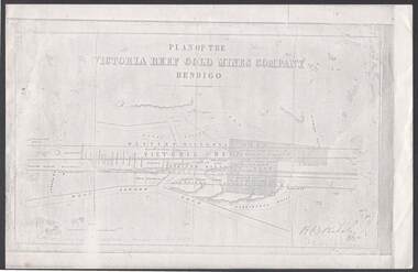 Bendigo Historical Society Inc.
Document - VICTORIA REEF GOLD MINES COMPANY BENDIGO PLAN
Photocopy of a Plan of the Victoria Reef Gold Mines Company, Bendigo. Shaded area is the Victoria Reef Gold Mines Company Lease No. 2 and Lease No. 3. The gullies are named Happy Valley, Long, Derwent, Providence and Ironbark Gullies. The reefs are: Western Victoria, Victoria, Eastern Victoria and Prince Albert Reef. Between the Eastern Victoria Reef and the Prince Albert Reef is the White Lead. Mount Korong Road is at the bottom of the plan. Other Leaseholders are: Burrows, Wybrant, Ballerstedt, Jackson,Roberts & Co, Ashley, Grant, ?rpe, ?eau, Woodward, Coath, Taylor, Cranshaw, Roberts, Gould & Co, Midway, Witscheibe, Endeavour Co, Albert Co, Ballerstedt & Son, Late Iron Bark Quartz Mining Co, McDougall, Specimen Hill Co, Hygrect?, Wheadon, Evans and Bannerman. Signed by H. B. Nicholas. Location of Ballerstedt, Luffsman, Midway Co, Witscheibe and Rae & Co engine locations. Hills are shown as hatch shading. Written at the bottom left ocrner is: Accompanying prospectus issued in Nov. 1859. Signed H.B. Nicholas.plan, bendigo, victoria reef gold mines company, victoria reef gold mines company bendigo - plan, h b nicholas, burrows, wybrant, ballerstedt, jackson, roberts & co, ashley, grant, ?rpe, ?eau, woodward, coath, taylor, cra-shaw, roberts, gou-d & co, midway, witscheibe, endeavour co, albert co, ballerstedt & son, late iron bark quartz mining co, mcdougall, specimen hill co, hyo?, wheadon, evans, bannerman.