Showing 112753 items
matching tracks/roads
-
 Ballarat Tramway Museum
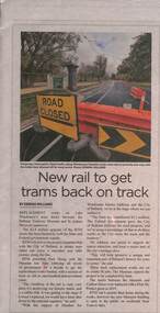
Newspaper, New rail to get trams back on track - 7-4-2022
Article with a photo about the commencement of reconstruction of Wendouree Parade by the Museum. Has quote from Juliana Addison re the project and funding. Photo is of road work signage at St Aidans Drive. Article and photo by Edwina Williams.Yields information about the track replacement in Wendouree Parade.Newspaper - New rail to get trams back on track - Ballarat Times News Group, published Thursday 7-4-2022btm, track replacement, wendouree parade, track work, st aidans drive -
 Geelong Cycling Club
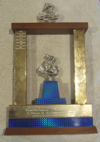
Memorabilia - Trophy, 1983-1988
This trophy was important in the years 1983-1988 as it recorded the winners of the prestigious Road Race run by the Geelong West Cycling Club over those years. The 1985 winner - Don Wilson was a two time Australian Open Road Race champion and also represented Australia in the 1968 Olympic Games in Mexico in the cycling road race. This trophy records the winners of a Road Race run by the Geelong West Cycling Club during the years 1983-1988.Trophy for winner of the Penn Memorial Road Race. The trophy is in the shape of a gateway with one silver representation of a cyclist on the top of the gateway and another on a pedestal in the middle of the gateway. The two inner supports to the gate have a stylised decorative pattern on them in black, gold and red. On the left hand upright winners' names have been engraved. Additional engraving is at the base of the trophy."Geelong West Cycling Club/PENN MEMORIAL - ROAD RACE/IN HONOUR OF R.L. PENN(Senior) W.J. PENN/ Donated By The - Penn Families/1983 Z. Szalinski/1984 A. McPherson/1985 Don Wilson/1986 Ken Lewins/ 1987 Peter Wood/1988 Peter Cotter"geelong cycling club; geelong west cycling club; penn memorial road race; penn family; z. szalinsk; a. mcpherson; don wilson; ken lewins; peter wood; peter cotter; -
 Glen Eira Historical Society
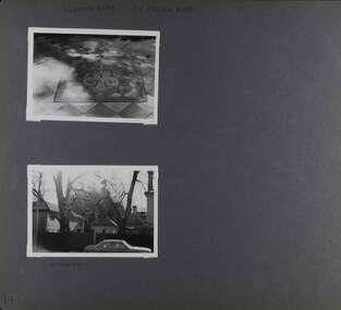
Album - Album page, Heatherbrae, 73 Neerim Road, Circa 1972
This photograph is part of the Caulfield Historical Album 1972. This album was created in approximately 1972 as part of a project by the Caulfield Historical Society to assist in identifying buildings worthy of preservation. The album is related to a Survey the Caulfield Historical Society developed in collaboration with the National Trust of Australia (Victoria) and Caulfield City Council to identify historic buildings within the City of Caulfield that warranted the protection of a National Trust Classification. Principal photographer thought to be Trevor Hart, member of Caulfield Historical Society. Most photographs were taken between 1966-1972 with a small number of photographs being older and from unknown sources. All photographs are black and white except where stated, with 386 photographs over 198 pages.From Victorian Heritage Database citation for Heatherbrae HO46 https://vhd.heritagecouncil.vic.gov.au/places/120933 as at (28/10/2020) "Heatherbrae" at 73 Neerim Road, Glenhuntly, is a substantial Victorian residential complex made up of two principal construction stages (pre 1876 and c. 1890) and outbuildings including stables. It is aesthetically, historically and socially significant. Its aesthetic value is demonstrated by the manner in which the two periods of construction survive, the earliest being of greater architectural interest on account of its tower and facade treatment, the latter phase adopting a common villa form. The importance of the complex is heightened by its intact state and surviving outbuildings. "Heatherbrae's" historical significance lies in its link with locally known business man and Shire of Caulfield councillor, John Charles Holland. Its social value rests on its ability to demonstrate a past lifestyle. Page 143 of Photograph Album with 2 landscape photographs of Heatherbrae on Neerim Road - paving insignia and side view.Handwritten: "HEATHERBRAE" 73 NEERIM ROAD [top] / STABLE [under bottom photo] / 143 [bottom left]trevor hart, chimneys, cast iron columns, return verandah, garden, 1870's, neerim road, booran road, 1880's, 1890's, mansion, john c. holland, bluestone foundations, italianate, iron roofed balcony, cast iron balustrade, mosaic tiles, cast iron lookout, flagpole, george f griffiths, residential villa, caulfield, heatherbrae, victorian style, cast iron work, stables, outbuildings, john holland, george griffiths, councillors, mansions -
 The Beechworth Burke Museum
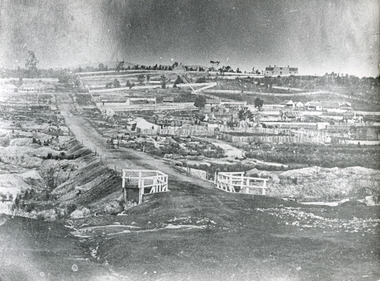
Photograph, c.1863
Taken in Beechworth, this photograph depicts Albert road bisecting the Spring Creek Diggings. The foreground of the photograph features a small bridge, while in the background, right-hand-side, Benevolent Hospital can be seen. In the centre of the photograph can be seen a horse and cart travelling along the road. This photograph shows historical and research value in its depiction of Beechworth in the late 1800s. It features a key historical site, the Benevolent Hospital, as well providing a historical look at a street that operates in Beechworth in the present day.Black and white, rectangular photograph printed on matt photographic paper, unmountedReverse: PH 238 / 1997.2462 / Albert Road . 1863 . 1800s beechworth, 1860s beechworth, beechworth, spring creek, benevolent asylum, albert road -
 Marysville & District Historical Society
Photograph (item) - Colour tinted photograph, Valentine Publishing Co. Pty. Ltd, The Road to Cumberland Valley, Marysville. No. 1, 1923-1963
An early colour tinted photograph of the intersection of the Buxton Marysville Road and the Marysville-Wood's Point Road.An early photograph of the Buxton Marysville Road and the Marysville-Wood's Point Road intersection. The Marysville-Buxton Road joins the Maroondah Highway which leads to Alexandra. The Marysville-Woods Point Road was originally part of the Yarra Track, constructed in the early 1860s to provide access between Healesville and the Woods Point Goldfields. Despite the steep terrain and engineering difficulties, the Yarra Track soon became a busy route used by pack horses, horse-drawn drays, and wagons. Today this sealed mountain road is a popular scenic drive between Marysville and Warburton. On the right of the photograph can be seen 'The Crossways Hotel' which is circa 1920 and one of the oldest buildings still standing in Marysville. 'The Crossways Hotel' survived the 2009 Black Saturday bushfires, through the efforts of the owner using buckets of water from the nearby Steavenson River. In the background can be seen the Poontawan Guest House which later became the Marysville Chalet Guest House which was on the site of the original Steavenson's Hotel. That guest house no longer exists and the Christ Church stands on the land where the guest house once stood. This photograph was published by the Valentine Publishing Co Pty. Ltd as a souvenir of Marysville.marysville, victoria, marysville chalet guest house, crossways hotel, christ church marysville, poontawan guest house, steavenson's hotel, valentine publishing co, souvenir, yarra track, wood's point road, mining, buxton-marysville road, marysville-wood's point road, maroondah highway, alexandra -
 Bendigo Historical Society Inc.
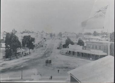
Photograph - HARRY BIGGS COLLECTION: EAGLEHAWK ROAD
Photograph. Harry Biggs Collection. 1 black & white photo of Eaglehawk Road from Town Hall towards Bendigo. A coach is on the road. 3 children are in the foreground. There are shops either side of the tram tracks. A large flag is on the right side of the photo. People are standing around the shops.photograph, streetscape, eaglehawk, harry biggs collection, eaglehawk road -
 Orbost & District Historical Society
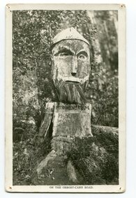
black and white photograph, 1920s
Pons asinorum was the name given to a wooden carving made by road worker Finlay Munro in the early 1920s at Boulder Creek, on the old Princess Highway, between Orbost and Cann River. The carved face was said to mock the supervising engineer after an argument about putting the road alignment across a swamp that required new bridges. The Italian workmen had advocated for a different route to avoid the need for building new bridges across the swamp. This photograph is from a set of thirteen black and white postcards in a fold-out format.This is a photograph of an iconic tourist attraction which records the woodworking skills of workers in the early 20th century. The carving is no longer there.A small black / white photograph of a face carved into a tree stump.on front at bottom - ON THE ORBOST CANN ROADwoodcarving pons-asinorum boulder-creek-east-gippsland princess-highway -
 Mt Dandenong & District Historical Society Inc.
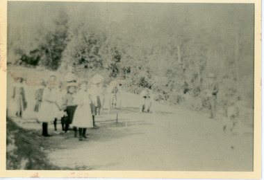
Photograph, School Sports Olinda 1909
View of school children from Olinda State school at the Sports on Mernda (now Coonara) Road in 1909. The descriptive text on the reverse of this photograph was hand written by John Lundy-Clarke.Olinda 1909 School sports on the (now) Coonara Road below the school. olinda, sports, sports carnival, mernda road, coonara road, olinda school, school, school children -
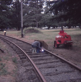
 Ballarat Tramway Museum
Photograph - Colour Photograph/s, Richard Gilbert, c1980
Yields information about the track laying for No. 5 road, c1980.Laminated A4 black white print of the laying of the track in the front of the depot on No. 5 road, c1980 with Lindsay Rickard and Warren Doubleday in the photograph. Print made 9/2009 for exhibition purposes and laminated.trams, tramways, btm, depot, trackwork -
 Lakes Entrance Historical Society
Photograph - Tambo Water Board, Lakes Post Newspaper, 1994
Black and white photograph of Ian Bunty Bulmer Tambo Waterboard inspecting pipe laying to connect the waste water facility at Golf Links Road to Bruce's track disposal facility Kalimna Victoriawater resources -
 Eltham District Historical Society Inc
Slide, West side of Bonds Road at culvert end wall, Lower Plenty, 18 July 1972, 1972
Water drainage work undertaken by Eltham Shire Council in Bonds Road, Lower Plenty outside the Martin property opposite Montpelier Drive, July 1972 Pitchers in foreground were part of the end wall which was eroded out due to water crossing the road and not going through the culvert. 35 mm colour positive transparency Mount - Agfacolor Service (Blue)Bonds Road (Martin property) 12.10 pm 18.7.72bonds road, drainage works, eltham shire council, infrastructure, lower plenty, martin property, montpelier drive -
 Bendigo Historical Society Inc.
Photograph - HARRIS COLLECTION: MALE PHOTO
Studio portrait man aged around 40 years. Beard & moustache. Written caption on reverse 'Capt. Riddie' 1896. Printed on reverse. Artist & Photographer A J Hilder 267 Barking Road Plaistow E. Same printed on front.A J Hilder 267 Barking Road Plaistow Essex.photograph, person, male -
 Kew Historical Society Inc
Photograph - Filling in the Outer Circle Railway cutting at East Kew, 1939
W.D. Vaughan (Kew's Civic Century, 1960, pp.195-6) quotes Council Minutes of 1938 and 1939 to record that: "After protracted negotiations between the Council, the Railways Department and the Tramways Board agreement was reached in June, 1938, for the filling of the railway cutting at the Harp Junction and shifting tram tracks to the High Street alignment ... The Outer Circle railway land from Princess Street to Park Crescent was purchased by the Kew Council in October, 1939, for 2,750 [pounds]. The land from Park Crescent to High Street was leased for 1 [pound] per annum. Considerable work was done in levelling the embankments to the original surface level."Important and rare photograph of the period, showing major works by Kew Council in Kew East working on a significant piece of urban infrastructure.Small, original black and white positive (photograph) showing workers and vehicles filling in the tracks of the former Outer Circle railway at East Kew. In the background is the metal bridge with brick piers, adjacent to the Harp Junction. The bridge crossed the cutting, linking the two parts of High Street. Behind the tip truck, painted on the side with the name 'Fowler Quarries' [located Keilor Road, North Essendon], one can see shops [including T.G. Garroway, Cash Grocer] in High Street. What appears to be the City of Kew Steamroller is immediately in front of the bridge. A group of passers-by watch from the bridge and from the road. Annotation in pencil on verso: "Filling in Outer Circle line at High St East Kew prior to straightening High St. (c. Feb 1930?)outer circle railway, railway cuttings, harp junction, high street -- kew east -
 St Kilda Historical Society
Photograph, c. 1970s?
stamped on back: Country Roads Board negaitve no. 75 3124Gblack and white photograph unmounted, good conditionH7 St Kilda road. When reproduced Pleas acknowldge Country Roads Board, Victoria Australia. Negative no. 75-3124G. Date: �., General Description:�.. -
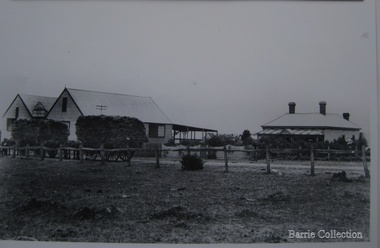 Melton City Libraries
Photograph, Chaff cutting and hay-pressing mills, 1909
In the early 1900’s Charles Ernest Barrie and his brother Ted were in partnership in a Chaff cutting and Ha y processing Mill on the corner of Station and Brooklyn road Melton South. By 1906 Charles Ernest and James Edwin were in partnership in the Station Road mill when a connecting rail line across Brooklyn Road for a siding was constructed to the Melton Railway Station. In 1911 the Mill’s letterhead shows C.E. BARRIE Hay Pressing and Chaff Cutting Mills. This Mill as sold to H S K Ward in 1916 and stood until 1977 when it burnt down in a spectacular fire.Owned by C.E Barrie. Buildings were on the west side of Station Road in Melton South, 100 metres north of Brooklyn Roadlocal identities, pioneer families, agriculture -
 Melbourne Tram Museum
Document - Research Notes, H. S. McComb, development and timing of the "PMTT" - part 2, 1950's
Set of papers, handwritten concerning the development and timing of the "PMTT", Prahran and Malvern - about 40 sheets. Prepared by H. S. McComb - gives layout of the PMTT system, primarily of Burke Road, sketches of track layout, opening dates, sketches of various junctions, bridges, track miles, junctions, reconciliation of track lengths from various sources includes Whitehorse Road, Victoria St cable tram terminus, Kew Depot, Candy Corner, St Kilda terminus, Malvern Depot, High St, Items 2041 to 2052 within box 72.3 in a brown folder marked "PMTT" in red pencil.trams, tramways, pmtt, malvern, routes, track, kew depot, burke rd, surveys, victoria st, whitehorse rd, malvern depot, st kilda, candy corner -
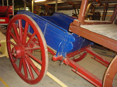 Maldon Vintage Machinery Museum Inc
Tip Dray, Late 19th century
Used for carting rock to crushing batteries, road making, railway track building.Single horse drawn tip dray, restored by G & S Little in 1999. Made of timber with metal fittings and wheel rims. Enclosed sides with hinged front and rear panels. Chassis and wheels painted dark red, body in dark blue.Rectangular brass plaque on LHS looking forward detailing restoration and possible usage.transport ..... horse-drawn -
 Melbourne Tram Museum
Newspaper, The Argus, "Railway to Edenhope, Demand for Redgum, use for Road Blocking", 20-1-1927
Provides information on the cost of wood blocking tram tracks in Melbourne with wood blocks - Red gum and Jarrah - part of a Parliamentary enquiry into the construction of a railway to Edenhope. The line was authorised but not built.Yields information about the cost of wood blocks for use in tram tracks.Extract via Trove - 3A4 sheets when printed - Railway to Edenhope, Demand for Redgum, use for Road Blocking" - The Argus 20-1-1927tramways, tram tracks, wood blocks, parliament, edenhope, new railways -
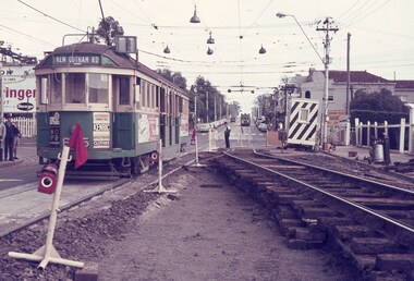
 Ballarat Tramway Museum
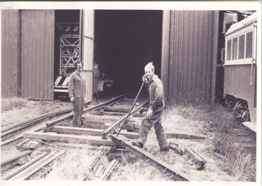
Slide - 35mm slide/s - set of 10, John Theodore, c1973
Yields information about depot activities of the BTPS in building the depot fan and access track.Set of 10 Agfa blue and white plastic mounts - 27mm square slides or 35mm slides of BTPS workers, c1973/1974 preparing rail joints or welding them. .1 - welding access track .2 - setting up to weld track .3 - welding access track .4 - installing fish plates prior to the extension of 2 road across the level crossing - Noel Gipps .5 - Cutting Rail - Noel Gipps and Barry McCandlish .6 - Cutting Rail - Noel Gipps, Barry McCandlish and Bill Kingsley .7 - welding track across the curve in Wendouree Parade .8 - ditto with Richard Gilbert and Noel Forster .9 - welding track across the curve .10 - dittoVarious notations by John as to the slide number and the trams in pencil and ink.tramways, trams, btps, depot, trackwork, wendouree parade -
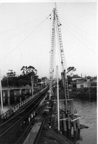 Ballarat Tramway Museum
Photograph - Black & White Photograph/s, mid to Late 1965
Set of two Black and white photographs of the pile driving for the reconstruction of the Maribyrnong River Bridge from a tramway only bridge to a dual road/tram bridge. The road bridge is in the background. On Kodak paper. Photo during the 2nd half of 1965. 1419.1 - Early in the process of pile driving - Bridge tram track has been reduced to single track and the former outbound line is in use for construction purposes. 1419.2 - Roadway west of bridge looking east. Shows temporary single track arrangement which allowed the operating track to switch to the south side when piling completed. W5 682 West Maribyrnong on route 57 coming off the bridge. See P.Winspur note - and Rail News Victoria May 2000, page 50. Features a photograph of a tour on the bridge on 1/10/1966.trams, tramways, maribyrnong river bridge, bridge construction, trackwork, mmtb, tram 682 -
 Ringwood and District Historical Society
Land titles and plan, Victorian Titles Office, Titles and plans of Ringwood Land between Mullum Land and Wonga Rd. (Re Ann Jane Kennedy). 1907, 1-Oct-07
The documents pertaining to Ann Jane Kennedy inheriting the land from her late husband Samuel John Kennedy and the history of the transfers of land from Ann Jane Kennedy in 1907 until the title was cancelled in 1925 to James Melbourne Ross. The area was 10 acres between Mullum Mullum Road and Wonga Road retrieved from Titles Office.Ten pages of photocopied titles and plans of land in Ringwood between Mullum Road and Wonga Road, also transfer of original land. -
 Melbourne Tram Museum
Slide, Keith Caldwell, March 1968?
Agfa colour blue white plastic mount slide, photo by Keith Caldwell of W2 605 or 625, southbound in Glenferrie Road, at the Kooyong level crossing. Glenferrie Road is being reconstructed with the north bound track in a temporary location. Tram has advert for Kenric clothes and Exide? batteries. The night watchman is watching the tram. His cabin is behind him.. The tram is showing (incorrectly) Kew Cotham Road destination. This is a Camberwell Depot tram bound for Malvern Town Hall assisting movement of School children in Glenferrie Road in the afternoon. Note the Camberwell Run number in the driver cab window. On the north bound track is possibly a SW6. Slide undated - c1968?trams, tramways, glenferrie rd, kooyong, level crossings, temporary track, w2 class, trackwork, kew- cotham road, tram 605, tram 625 -
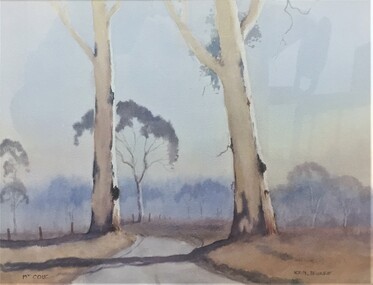 Pyrenees Shire Council
painting, Ken Burke, Mt Cole by Ken Burke, 2001
significant as a work of art by local Pyrenees artist, locally significant to the Central Highlands Region of Victoria as a representation of local landscape and/or culture watercolour painting of a bush track with two trees (Jimmy Smith Track, Mt Buangor State Park)"signed: KEN BURKE (lower right) MT COLE (lower left)" -
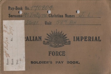 Lara RSL Sub Branch
Personal Records, Paybook, J.L.McIntyre
These paybooks were carried by John Lachlan McIntyre while on active service during the First World War. The books cover the period November 1915 to July 1919. Every soldier carried a paybook, and made an entry each time they were paid. Paybooks enable researchers to track the dates and places that a soldier served. These paybooks are associated with JL McIntyre, a founding member of Lara RSL. The books are highly personal objects carried with him every day, and would have formed a key element of his wartime experience. They are also significant as research materials, allowing researchers to track McIntyre's war experience. 2 Small khaki paybooks. One is landscape with a rising sun badge and text on the front. The other is portrait with a cloth cover and text. Each book has tables inside tracking dates and locations of payments made to JL McIntyre while on service. Book 1: Pay Book No. 170804 Surname McIntyre Christian Names J.L. 3591 Unit 58th Bn Australian Imperial Force Soldier's Pay Book. Book 2: JL McIntyre Soldier's Pay Book, For Use On Active Service 3591paybook, military, army, wwi, world war one, first world war, mcintyre, rsl, lara -
 Kew Historical Society Inc
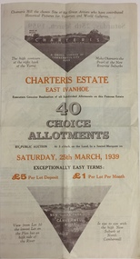
Plan - Subdivision Plan, Charteris Estate, East Ivanhoe, 1939
The Charteris Estate in Ivanhoe was sold in a number of sections. Copies of a subdivision plan of the first section is in the State Library of Victoria collection. This later section of the Charteris Estate includes lots in the Government Boulevard, Castella Street, McArthur Road, Burke Road North, Charteris Drive and Warncliff Road.Subdivision plans like that for the Charteris Estate are invaluable records for local historians identifying when lots in streets were promoted for sale.Four-fold brochure advertising the Charteris Estate in East Ivanhoe in 1939. Streets named on the plan include: the Government Boulevard, Castella Street, McArthur Road, Burke Road North, Charteris Drive and Warncliff Road. The brochure contains photos of Charterisville, the home of F De Castella Esq and also of attractive rolling hills. Annotations in pencilcharteris estate - east ivanhoe (vic), subdivision plans - east ivanhoe (vic) -
 Kew Historical Society Inc
Plan - Subdivision Plan, Charteris Estate, East Ivanhoe, 1939
The Charteris Estate in Ivanhoe was sold in a number of sections. Copies of a subdivision plan of the first section is in the State Library of Victoria collection. This later section of the Charteris Estate includes lots in the Government Boulevard, Castella Street, McArthur Road, Burke Road North, Charteris Drive and Warncliff Road.Subdivision plans like that for the Charteris Estate are invaluable records for local historians identifying when lots in streets were promoted for sale.Four-fold brochure advertising the Charteris Estate in East Ivanhoe in 1939. Streets named on the plan include: the Government Boulevard, Castella Street, McArthur Road, Burke Road North, Charteris Drive and Warncliff Road. The brochure contains photos of Charterisville, the home of F De Castella Esq and also of attractive rolling hills. Annotations in pencilcharteris estate - east ivanhoe (vic), subdivision plans - east ivanhoe (vic) -
Whitehorse Historical Society Inc.
Document, Agreement, n.d
Copy of agreement to release one thousand shares in the Mitcham Brick and Pottery Company to Madge Roff, Gustave Lachal and Charles Stewart Paterson .Copy of agreement to release one thousand shares in the Mitcham Brick and Pottery Company to Madge Roff, Gustave Lachal and Charles Stewart Paterson and giving permission for right of passage to the company on road between Lilydale Road and the Company.Copy of agreement to release one thousand shares in the Mitcham Brick and Pottery Company to Madge Roff, Gustave Lachal and Charles Stewart Paterson .pioneers, mcglone, john, mitcham brick and pottery co. ltd, roff, madge, lachal, gustave, paterson, charles stewart, murphy, william e -
 Ringwood and District Historical Society
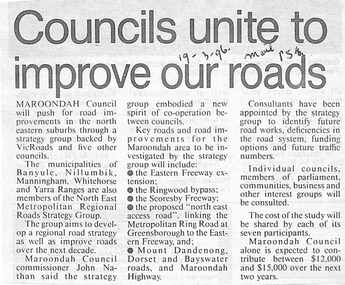
Newspaper, Scrapbook Clipping, Library Collection, Ringwood, Victoria
Newspaper Clipping from The Mail, 19-3-96, P 5. Councils unite to improve our roads.Maroondah Councilwill push for road improvements in the north eastern suburbs through a strategy group backed by Vicroads and five other councils. The municipalities of Banyule, Nillumbik, Manningham, Whitehorse and Yarra Ranges are also members of North East Metropolitan Regional Roads Strategy Group. -
 Kew Historical Society Inc
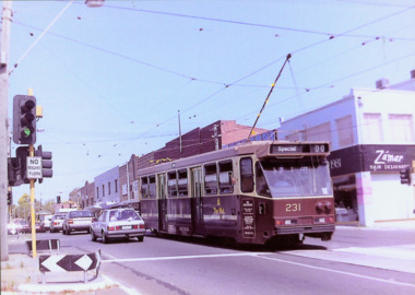
Photograph - A Class 231 in Doncaster Road, North Balwyn Village, 1990
This colour photograph, with 15 others are enlargements gifted to the Society by Mel Lawrence in 2016. They were taken at a commemorative event from the Kew Tram Depot. Laminated colour enlargement of an A Class 231 in Doncaster Road, North Balwyn Village during a re-enactment from the Kew Depot in 1990.Annotation reverse: "Kew Depot 1990. A Class 231 in Doncaster Road, North Balwyn Village."kew tram depot, a class trams, trams -- melbourne -
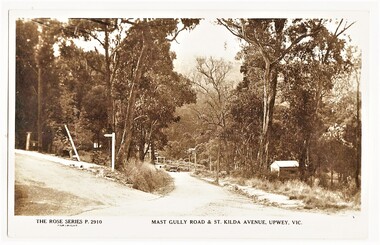 Sherbrooke Foothills Historical Society
Postcard - The Rose Series P.2910 Mast Gully Road & St.Kilda Avenue, Upwey, Vic. (identification item name), The Rose Series P.2910 Mast Gully Road & St.Kilda Avenue, Upwey, Vic. (identification title)
... Roads ...Rare view of mast Gully rd with sign post for St.Kilda Avenue ( contextual or historic information)Digital copy of original postcard published on ebay. The Rose Series P.2910 Mast Gully Road & St.Kilda Avenue, Upwey, Vic.( inscription) The Rose Series P.2910 Mast Gully Road & St.Kilda Avenue, Upwey, Vic.mast gully rd, st kilda ave, roads, upwey, signpost, rose series, subjects in context