Showing 110291 items matching "roads"
-
 Department of Energy, Environment and Climate Action
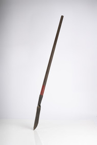
Heavy brush cutter
Used to clear scrub and undergrowth. Straight blade was useful when clearing road embankmentsHeavy Brush cutter Colour on handle indicates FCV district ownershipforests commission victoria (fcv), hand tools -
 Eltham District Historical Society Inc
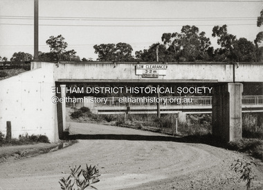
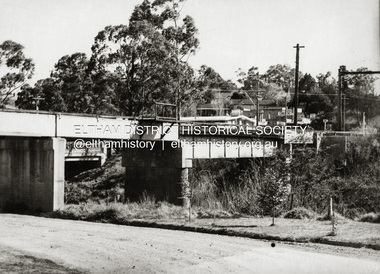
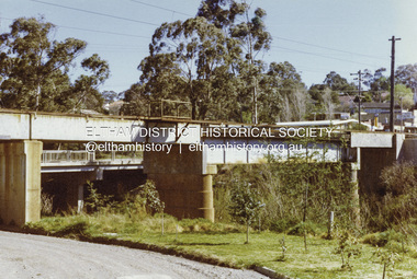
Photograph - Black and White Print, Railway Bridge across Plenty River near Railway Road, Briar Hill, Vic, c. August 1977
Para Road bridge across Plenty River can be seen behind railway bridge.Black and white photographinfrastructure, bridge, greensborough, para road bridge, railway road bridge, shire of eltham infrastructure -
 Eltham District Historical Society Inc
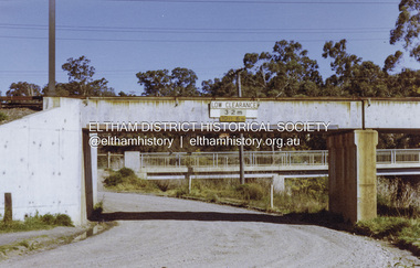
Photograph - Colour Print, Railway Bridge across Plenty River near Railway Road, Briar Hill, Vic, c. August 1977
Para Road bridge across Plenty River can be seen behind railway bridge.Colour photographinfrastructure, bridge, greensborough, para road bridge, railway road bridge, shire of eltham infrastructure -
 Eltham District Historical Society Inc
Photograph - Colour Print, Railway Bridge across Plenty River near Railway Road, Briar Hill, Vic, c. August 1977
Para Road bridge across Plenty River can be seen behind railway bridge.Colour photographinfrastructure, bridge, greensborough, para road bridge, railway road bridge, shire of eltham infrastructure -
 Lakes Entrance Historical Society
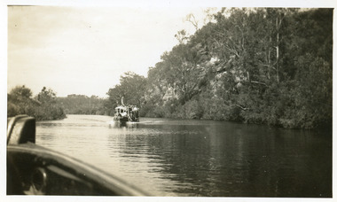
Photograph - Tambo River, 1950 c
Road between Swan Reach and Tambo Upper follows river bank opposite cliffsBlack and white photograph print showing tourist launch, possibly 'MV Blackbird' on Tambo River below the cliffs, taken from another boat. Tambo Upper Victoria waterways, boats and boating, tourism -
 Greensborough Historical Society
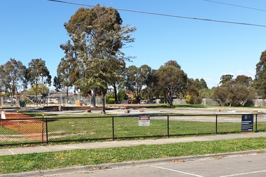
Photograph - Photograph - Digital Image, Marilyn Smith, Delta Road Reserve upgrade 2020, 15/08/2020
Digital images of the Delta Road Reserve upgrade due for completion 15/08/2020.Part of a collection of miscellaneous historical images with a connection to the local area.Digital colour photographsparks - greensborough, parks and reserves, delta road reserve, delta road greensborough -
 Canterbury History Group
Magazine, The Mangarrian CGSC 75th Anniversary, 2003
School magazine for Canterbury Girls High School 75th Anniversary56 pages, includes colour and black and white photographs: lists of staff and studentsnon-fictionSchool magazine for Canterbury Girls High School 75th Anniversary canterbury, canterbury girls secondary college, school -
 Greensborough Historical Society
Article - Oral History, Dawn Bennetts, The Little House on the top of The Hill, 2021
History about the property at 72 Greenhill Road, Greensborough and its connection to the Petts family.6 pages, text with black and white and colour photosoral history, dawn bennetts, greenhill road, petts family -
 Greensborough Historical Society
Article - Oral History, Dawn Bennetts (nee Petts), Our new house next door, 2021
Oral history about the building and life of 74 Greenhill Road in 1962 by the Petts family.Oral history article, black text and black and white and colour photosoral history, dawn bennetts, petts family, greenhill road greensborough -
 Melbourne Tram Museum
Photograph - Black Rock horse tram, 1900
Photo shows a north bound, Black Rock to Beaumaris horse tram in Beach Road.Yields information the Black Rock - Beaumaris horse tram.Black and white photograph with notes on the rear.In pencil "No. 14, 040, Black Rock"tramcars, tramways, horse tram, black rock tramway, beaumaris horse tram, beaumaris -
Canterbury History Group
Ephemera, 1987 Australian Heritage Award, 1987
Maling Road shopping centre nominated by Camberwell Council for the 1987 Australian Heritage Awardsa newspaper cuttingcamberwell city news, canterbury, maling road, urban renewal planning scheme -
 Greensborough Historical Society
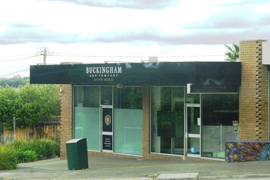
Photograph - Photograph - Digital Image, Marilyn Smith, Buckingham 53 Rattray Road Montmorency, 29/09/2019
Digital image of Buckingham and Company Real Estate office at 53 Rattray Road MontmorencyPart of a collection of miscellaneous historical images with a connection to the local area.Digital colour photograph of buildingmontmorency shops, buckingham & company real estate agents, rattray road montmorency -
 Whitehorse Historical Society Inc.
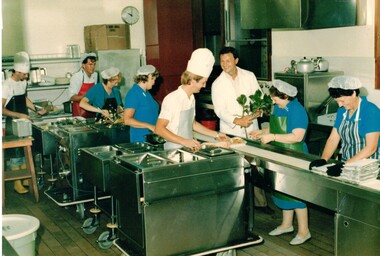
Photograph - Coloured Photograph, Meals on Wheels
Meals on Wheels kitchen was situated behind the shops on the southwest corner of Whitehorse & Springvale RoadsColoured photograph of workers preparing food for meals on wheels.meals on wheels, food service, volunteers -
 Federation University Historical Collection
Photograph - Colour, Chatham-Holmes Collection: On the road to Burrumbeet, 1987, 1987
Philip Chatham was responsible for the sub-division located on the road to Burrumbeat. Preparations for land sales.chatham-holmes collection, philip chatham, burrumbeat, land sales -
 Glen Eira Historical Society
Newsletter - St. Stephen’s Presbyterian Church, Caulfield
Featuring two photocopies of a sixteen page pamphlet by Della Hilton titled 75 Years at St. Stephen’s – Including Union with Bambra Road Methodist Church. This details a brief history of both the Bambra Road Church and especially the St. Stephen’s Presbyterian Church, Balaclava Road, Caulfield between 1910-1985. These churches united in 1976 to form the St. Stephen’s Uniting Church in Balaclava Road, Caulfield. The pamphlet includes copies of photographs of the interior, exterior and windows. There is a black and white photograph of the interior, undated and unattributed. There is a Christmas postcard from the church’s sponsor child, Paulus Lobo, dated post-1988. Finally, there is a copy of a fourteen page newsletter dated March 1986, edited by Ethel Phillips, regarding news of the St. Stephen’s Uniting Church Community.st. stephen’s church, presbyterian church, methodist church, uniting church, caulfield, balaclava road, bambra road, dulton street, kooyong road, hilton della, thomson w. rev., hunter c. hay rev., burns h.m. rev., simpson w. l. rev., goddard s.a. rev., tamagno f. rev., robinson e.b. rev., kerry g.f.g. rev., williamson j. rev., mclean d. rev., heazlewood vere rev., adamson j.c., pollard w.g. mr., alday rev., alday mrs., everett l.d. mrs., emms, ladies guild, presbyterian women’s missionary union, p.w.m.u., presbyterian girls’ association, presbyterian boys’ association, adult group, st. stephen’s players, men’s brotherhood, tennis club, cricket club, architectural features, gothic revival architecture, church furniture, stained glass, clergy residences, religious ceremonies, choirs, religious festivals, religious groups, clergy, religious structures and establishments, social clubs, clubs and associations, construction, events and activities, theatre groups, performers, fundraising events, community services, festivals and celebrations, sunday schools, organs, postcards -
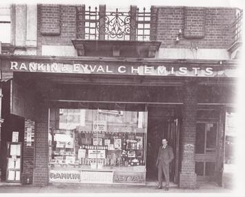 Glen Eira Historical Society
Photograph - Glenhuntly Road, Elsternwick
11 photographs of Glen Huntly Road, Elsternwick, from horsedrawn carriage days to the 1980s: A black and white photograph (200mm x 253mm) of Hulbert Gorrie standing outside the shop front of Rankin and Eyval Chemists at 35 Glen Huntly Road Elsternwick. Date and photographer unknown. Three black and white photographs (107mm x 130mm; 88mm x 140mm; 88mm x 88mm) of shop fronts on Glen Huntly Road taken in different eras. A horse drawn vehicle and women in long dresses are shown in one of the photographs. The other two most likely date to the 1960s. Exact dates and photographers unknown. Seven colour photographs of advertising signs revealed when a building on Glen Huntly Road was demolished in the 1980s to build the Bank of New South Wales.gorrie hulbert, rankin and eyval chemists, cast iron work, pharmacies, balconies, chemists, architectural features, advertising signs, selwyn street, p calandro and co, estate agents, elsternwick, chinese café, j higgins, glen huntly road -
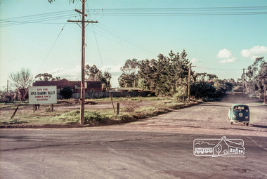 Eltham District Historical Society Inc
Slide, Site for the new Apex-Diamond Valley Ambulance Station, corner of Main Road and Grand Boulevard, Montmorency, July 1969, 1969
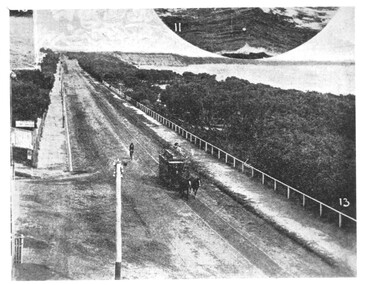
View looking west along Grand Boulevard from the intersection with Main Road and Panorama Avenue, Montmorency showing the site for the new Apex-Diamond Valley Ambulance Station and before construction of Apex Way, July 1969. The Eltham Apex Club conducted a Community Service Project (1965-1968) to raise funds for a new Ambulance Station to service the community. A site bounded by the intersection of Main Road, Grand Boulevard and Looker Road at Montmorency was purchased in 1969. In 1970, Eltham Shire Council undertook roadworks to construct Apex Way in preparation for the new station as well as duplicate Main Road, Lower Plenty, east of Grand Boulevard including the new Lower Plenty Bridge, which had been opened in November 1966, bordering with the City of Heidelberg.35 mm colour positive transparency Mount - Agfacolor Service (Blue)1969-07, ambulance station, apex way, grand boulevard, lower plenty, main road, montmorency, eltham ambulance station, apex-diamond valley ambulance station, eltham apex club -
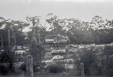
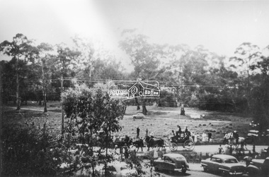
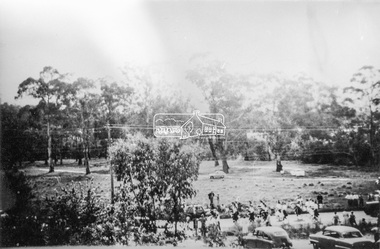
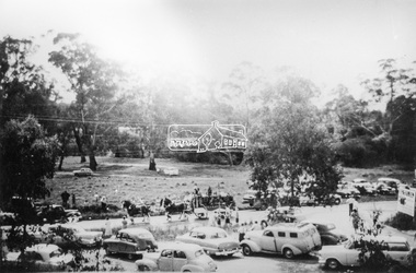
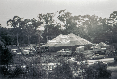 Eltham District Historical Society Inc
Slide - Photograph, Grace Mitchell, Ashtons Circus set up in Bremner's Reserve, Main Road, Eltham, c.1955
View from Grace Mitchell's shop at the corner of Mount Pleasant Road and Main Road. Grace Mitchell was probably best known for her Eltham shop at the corner of Mt Pleasant Road and Main Road. Grace's memories covered many local identities who were patrons of her shop between 1954 and 1971. From the elevated position of her shop and home Grace was able to view a varied passing parade of Eltham events from ERSILAC, Easter and Eltham Festival parades passing on their way to Eltham Lower Park, circuses in Wingrove Park (then Bremner’s Reserve), roadworks and other happenings. Bremner's Reserve was renamed Wingrove Park c.1970 This photo was from a series of images presented by Grace Mitchell at a Society talk 10 March 1993 on the theme of “My Eltham”.35mm Kodak 5052 TMX Black and White transparency, 1 strip, 6 frames Black and white print 17 x 25.4 cmashtons circus, bremner's flat, circus, grace mitchell, main road, mount pleasant road, wingrove park -
 Eltham District Historical Society Inc
Photograph, Grace Mitchell, Bremners Flat, Main Road, Eltham, 1958c
View from Grace Mitchell's shop at the corner of Mount Pleasant Road and Main Road. Grace Mitchell was probably best known for her Eltham shop at the corner of Mt Pleasant Road and Main Road. Grace's memories covered many local identities who were patrons of her shop between 1954 and 1971. From the elevated position of her shop and home Grace was able to view a varied passing parade of Eltham events from ERSILAC, Easter and Eltham Festival parades passing on their way to Eltham Lower Park, circuses in Wingrove Park (then Bremner’s Reserve), roadworks and other happenings. Bremner's Reserve was renamed Wingrove Park c.1970 This photo was from a series of images presented by Grace Mitchell at a Society talk 10 March 1993 on the theme of “My Eltham”.Black and white print 17 x 25.4 cmbremner's flat, main road, mount pleasant road, wingrove park -
 Eltham District Historical Society Inc
Photograph, Grace Mitchell, Diamond Creek in flood, Bremners Flat, Main Road, Eltham, c.1958
View from Grace Mitchell's shop at the corner of Mount Pleasant Road and Main Road. Grace Mitchell was probably best known for her Eltham shop at the corner of Mt Pleasant Road and Main Road. Grace's memories covered many local identities who were patrons of her shop between 1954 and 1971. From the elevated position of her shop and home Grace was able to view a varied passing parade of Eltham events from ERSILAC, Easter and Eltham Festival parades passing on their way to Eltham Lower Park, circuses in Wingrove Park (then Bremner’s Reserve), roadworks and other happenings. Bremner's Reserve was renamed Wingrove Park c.1970 This photo was from a series of images presented by Grace Mitchell at a Society talk 10 March 1993 on the theme of “My Eltham”.Black and white print 17 x 25.4 cmbremner's flat, diamond creek, floods, main road, mount pleasant road, wingrove park -
 Eltham District Historical Society Inc
Slide - Photograph, Grace Mitchell, Portable buildings on trucks possibly for installation at the Golden Fleece Service Station, corner of Main Road and Mount Pleasant Road, Eltham, c.1961
View from Grace Mitchell's shop at the corner of Mount Pleasant Road and Main Road. Grace Mitchell was probably best known for her Eltham shop at the corner of Mt Pleasant Road and Main Road. Grace's memories covered many local identities who were patrons of her shop between 1954 and 1971. From the elevated position of her shop and home Grace was able to view a varied passing parade of Eltham events from ERSILAC, Easter and Eltham Festival parades passing on their way to Eltham Lower Park, circuses in Wingrove Park (then Bremner’s Reserve), roadworks and other happenings. Bremner's Reserve was renamed Wingrove Park c.1970 This photo was from a series of images presented by Grace Mitchell at a Society talk 10 March 1993 on the theme of “My Eltham”.35mm Kodak 5052 TMX Black and White transparency, 1 strip, 6 frames Black and white print 17 x 25.4 cmgolden fleece service station, main road, mount pleasant road -
 Eltham District Historical Society Inc
Photograph, Grace Mitchell, Possibly the Ersilac Parade travelling along Main Road, Eltham, c.1958
View from Grace Mitchell's shop at the corner of Mount Pleasant Road and Main Road. Grace Mitchell was probably best known for her Eltham shop at the corner of Mt Pleasant Road and Main Road. Grace's memories covered many local identities who were patrons of her shop between 1954 and 1971. From the elevated position of her shop and home Grace was able to view a varied passing parade of Eltham events from ERSILAC, Easter and Eltham Festival parades passing on their way to Eltham Lower Park, circuses in Wingrove Park (then Bremner’s Reserve), roadworks and other happenings. Bremner's Reserve was renamed Wingrove Park c.1970 This photo was from a series of images presented by Grace Mitchell at a Society talk 10 March 1993 on the theme of “My Eltham”.Black and white print 17 x 25.4 cmcars, bremner's flat, eltham, ersilac parade, main road, mount pleasant road, wingrove park, festival, horse drawn carriage -
 Eltham District Historical Society Inc
Photograph, Grace Mitchell, Possibly the Ersilac Parade travelling along Main Road, Eltham, 1958c
View from Grace Mitchell's shop at the corner of Mount Pleasant Road and Main Road. Grace Mitchell was probably best known for her Eltham shop at the corner of Mt Pleasant Road and Main Road. Grace's memories covered many local identities who were patrons of her shop between 1954 and 1971. From the elevated position of her shop and home Grace was able to view a varied passing parade of Eltham events from ERSILAC, Easter and Eltham Festival parades passing on their way to Eltham Lower Park, circuses in Wingrove Park (then Bremner’s Reserve), roadworks and other happenings. Bremner's Reserve was renamed Wingrove Park c.1970 This photo was from a series of images presented by Grace Mitchell at a Society talk 10 March 1993 on the theme of “My Eltham”.Black and white print 17 x 25.4 cmcars, bremner's flat, eltham, ersilac parade, main road, mount pleasant road, wingrove park, festival, horse drawn carriage -
 Eltham District Historical Society Inc
Photograph, Grace Mitchell, Possibly the Ersilac Parade travelling along Main Road, Eltham, c.1958
View from Grace Mitchell's shop at the corner of Mount Pleasant Road and Main Road. Grace Mitchell was probably best known for her Eltham shop at the corner of Mt Pleasant Road and Main Road. Grace's memories covered many local identities who were patrons of her shop between 1954 and 1971. From the elevated position of her shop and home Grace was able to view a varied passing parade of Eltham events from ERSILAC, Easter and Eltham Festival parades passing on their way to Eltham Lower Park, circuses in Wingrove Park (then Bremner’s Reserve), roadworks and other happenings. Bremner's Reserve was renamed Wingrove Park c.1970 This photo was from a series of images presented by Grace Mitchell at a Society talk 10 March 1993 on the theme of “My Eltham”.Black and white print 17 x 25.4 cmcars, bremner's flat, eltham, ersilac parade, main road, mount pleasant road, wingrove park, festival, horse drawn carriage -
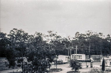
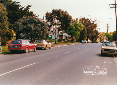 Eltham District Historical Society Inc
Photograph, Looking west near 942 Main Road, Hurstbridge, c. Oct 1987, 1987
Yvonne's Dressmaking and Alteration Service at 942 Main Road. Formerly a bakery, the building was demolished in 1990 and is now the site of Hurstbridge Saddlery. The milkbar is down the road, brick wall with a blue sign on it. There's still an older house next to the milkbar, but that's hidden from view in this shot as it's further back from the road. Date based on other similar display panels visible in images of the Shire of Eltham display at the Eltham Community Festival, 7 November 1987. Shire of Eltham Engineering Department Providing the resources to undertake • Survey, design, consultation • Road construction and maintenance • Bridge construction and maintenance • Street sweeping • Drain and pit cleaning • Traffic engineering installation and maintenance • Garbage collection • Tip management, land reclamation and beautification • Maintenance of community buildings • Provision of community and recreation facilitiesPhoto print mounted on carddisplay panel, eltham festival, heidelberg-kinglake road, hurstbridge, hurstbridge milk bar, infrastructure, main road, mm, shire of eltham, yvonne's dressmaking and alteration service -
Glen Eira Historical Society
Plan - Kooyong Road, 18, Caulfield North
Copies of correspondence, (5 pages) dated 8/07/1954 from valuer to Mr K W Blue concerning valuation of property at 18 Kooyong Road, Caulfield North. Correspondence provides property measurements, details of property, improvements and costings. In addition, the file also includes 2 pages of handwritten notes, undated and unattributed providing valuation details. Also included in the file is a hand-drawn property plan (150mm x 155mm) undated and unattributed. The plan may be of the property at 18 Kooyong Road ; the room measurements given by the plan correspond with the measurements for 18 Kooyong Road given by the correspondence. However, the plan has been labeled (in a biro pen) as 15 Kooyong Road, East St Kilda, though 18 has been written above the number 15.blue k w, a’beckett mrs, kooyong road, malonga court, caulfield, east st kilda, brick houses, land values, caulfield north -
 Surrey Hills Historical Society Collection
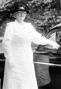
Photograph, Mrs Emma Atkinson
Emma was born in East Doncaster in 1903, the daughter of Carl Heinrich Uebergang and Sarah Buck. Emma’s grandparents were pioneers in Doncaster from 1855 and her father had an orchard in Andersons Creek Road, which was sold in 1961. Mr & Mrs Atkinson had a green-grocery business and general store at 815 Whitehorse Road, almost on the corner of Elgar Road from 1930 until about 1950. (See file for further details). In retirement the couple lived at 63 Zetland Road, Mont Albert and William continued to work as an orchard hand. Emma died in 2000 and is buried in Templestowe Cemetery. In this photo Mrs Atkinson is in the uniform of St. Johns Ambulance. In 1963 she was awarded a ‘Medal of Honour for Efficient Service’ by the Governor Sir Rowan Delacombe. (See file for further details) A black and white photograph of a lady dressed in a white uniform, complete with hat and gloves, standing beside a car.st. john ambulance, awards, miss emma gertrude uebergang, miss emma gerte uebergang, mrs william james atkinson, mrs emma atkinson -
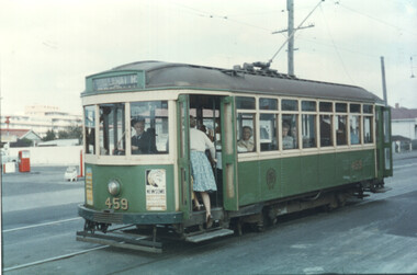 Melbourne Tram Museum
Photograph - Set of six colour prints - last day of local Footscary lines, 10/2/1962
Colour prints showing some of the trams used on the last day of local Footscray services. 1 - X1 459 - picking up a passenger in Ballarat Road - has a service station in the background and the Footscray Hospital 2 - X1 459 and another X2 in Leeds St Footscray. 3 - X1 467, and another X1 and X2 677 at Footscray Tram depot for the AETA tour. (Reference provides information that X2 468 was the second car) 4 - X1 468 with the destination of Williamstown Road turning into Leeds St from Hopkins St 5 - X2 677 and two X1s at Footscray Station in Leeds St. - on the AETA tour. 6 - X2 678 turning from Ballarat Road into Droop St showing the "Ballarat Road" destination. Note Kinnears Rope works building behind the tram.Yields information about the AETA tour to mark the closure of the Footscray local system. Set of six Colour print on Kodak Royal paper.trams, tramways, footscray, ballarat road, leeds st, x1 class, x2 class, aeta tours, tram 459, tram 678, tram 467, tram 468, tram 677, mmtb, footscray depot