Showing 1541 items
matching 1889
-
 Kilmore Historical Society
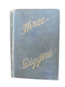
Three Diggers, 1889
A Tale of the Australian 1850's.Green cloth-bound hardcover book. Faded cover with worn edges & spine. Loose binding, cover separating from body. Ragged edges to pages. Moderate foxing throughout. 261 pp. Fair condition.Flyleaf, '2012' crossed out, '1012' underlined. Kilmore Mechaics Institute stamp.adult fiction, kilmore mechanics institute library. -
 Kilmore Historical Society
KAYE 'S AND MALLESON'S HISTORY OF THE INDIA MUTINY OF 1856-8, Kaye's and Malleson's History of the India Mutiny of 1856-8. Vol. 3, 1889
Red cloth cover with gold writing on the spine, cover worn with some loss of colour. Good condition. 388ppFront flyleaf, '204' in ink/ Kilmore Mechanics Institute stamp.india, mutiny, history, kilmore mechanics institute library. -
 Canterbury History Group
Drawing - Illustration, Hotel, corner of Canterbury & Sutherland Sts. Melbourne, February 1889
Photocopy of the original architect's( W. Wolf ) drawing of the hotel built for W.Maloney esq. in Canterbury.canterbury, canterbury road, sutherland street, wattle valley road, malones hotel, canterbury mansions, wolf> w -
 Mrs Aeneas Gunn Memorial Library
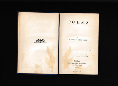
Book, Macmillan And Co, Poems: by Charles Kingsley, 1889
A collection of poems by Charles Kingsleyp.347.non-fictionA collection of poems by Charles Kingsleyenglish poetry, charles kingsley 1819-1875 -
Port Melbourne Historical & Preservation Society
Book - Borough of Port Melbourne Valuation 1890, 1889 - 1890
Valuation book, Borough of Port Melbourne 1890. 170 spreads completed listing name and occupation of tenant and owner of each property, description, number of rooms, size of property, rental etc. (Decorative) red cover, maroon spine with title gold-stamped. (also Rates; assessments)local government - borough of port melbourne, built environment, charles henry martin, joseph turner -
Linton Mechanics Institute and Free Library Collection
Book - Novel, Barrie, J. M, A Window in Thrums by J.M. Barrie, [n.d.] [1889]
Romance novHardcover book with 217 pages. Book has a red cover.fictionRomance novj.m. barrie, romance, fiction -
![Book - Novel, Southworth, Mrs (Emma Dorothy Eliza Nevitte Southworth), Her Mother's Secret by Mrs. Southworth, [n.d.] [1889?]](/media/collectors/641920217f0478323d8a47a8/items/65611d4b4271c4bd36b3efcb/item-media/65b03b84643192192d94ceeb/item-fit-380x285.jpg) Linton Mechanics Institute and Free Library Collection
Linton Mechanics Institute and Free Library CollectionBook - Novel, Southworth, Mrs (Emma Dorothy Eliza Nevitte Southworth), Her Mother's Secret by Mrs. Southworth, [n.d.] [1889?]
Hardcover book, 307 pages. Cover of book has blue printed text. Image of a woman. Title page missing, information for catalogue record from online sources and publisher's catalogue at back of book.fictionmrs. southworth, fiction -
 Vision Australia
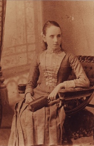
Photograph - Image, Tilly Aston aged 16, 1889-1893
Photo of Tilly Aston as a young girl of 16 sitting in a chair with a handbag in her lap. She wears a high necked dress and her hair is pulled back behind her in a ponytail. Image has been produced in a sepia and black and white. Black and white copy has 'about 1920' on back, however this date is incorrect as Tilly would have been almost 50 that year.1 photograph in various tones of Tilly Aston aged 16tilly aston, royal victorian institute for the blind -
 Bendigo Historical Society Inc.
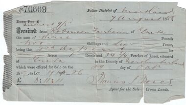
Administrative record - Land purchase records - Maitland NSW, 1888-1889
Northumberland County was one of the original Nineteen Counties in New South Wales and is now one of the 141 Cadastral divisions of New South Wales. The Greta area was first colonized by Europeans around Anvil Creek in the 1830s. When the town was surveyed in 1842 it was given the name Greta, possibly after a small river in Cumberland, England. Coal mining was established in the area in 1862 with the development of a railway station.Robinson Fairbairn Collection: Two documents. 1. Receipt for payment from Robinson Fairbairn of Greta for purchase of land at Greta, NSW. Dated 7th August 1888. Receipt for £3/11/11 includes Interest noted at top. 2. Invoice to Mr. Robinson Fairburn for land purchase in account with Sparke and Clift, Auctioneers, West Maitland. mining, robinson fairbairn collection, maitland, northumberland, greta nsw, sparke and clift, coal -
 Lakes Entrance Historical Society
Photograph - Thomas Laughton, 1889
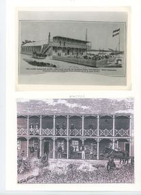
Lakes Entrance Hotel erected 1878 by Thomas Laughton Also second sketch of front of the hotel with 6 people on upper balcony Black and white photograph of a drawing of the Lakes Entrance Hotel. It shows a stylised view of a large weatherboard building with verandah across the main entrance with a viewing platform above. Horse drawn vehicle beside hotel, signal flagpole at front, a schooner and steamer in distant waterway. Lakes Entrance Victoria. Second sketch of front of hotelThe Lakes Entrance Hotel (immediately opposite the Southern Ocean Cunninghame) Edwin Stephenson Proprietor(under the patronage of the Governor Sir H B Lock K C B). Also second sketch of front of the hotel buildings, hotels -
 Bendigo Historical Society Inc.
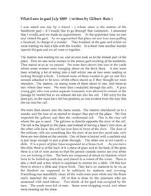
Document - GILBERT RULE COLLECTION: WHAT I SAW IN GAOL JULY 1889 - GILBERT RULE, 1889
Document - typed copy of article written by Gilbert Rule following a visit to the Sandhurst Gaol.person, individual, gilbert rule -
Lakes Entrance Historical Society
Postcard - Scene Near Lake Tyers, Pictorial Atlas of Australia, 1889
Coloured lithographic postcard showing small clearing in bush, bark barn, paling fence, three cattle and one man, small building among trees in Gippsland VictoriaNear Lake Tyersfarming -
 Alfred Hospital Nurses League - Nursing Archive
Medal, Nurse Annie Rentle medal, 1889
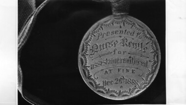
This medal was presented to student nurse Annie Rentle in recognition of her efforts during the fire that destroyed Wards 4 and 6 on Boxing Day 1888. Patients had to be rescued after the main staircase collapsed. All the patients survived and the nurses remained calm and in control throughout the emergency. Annie Rentle graduated in 1890This unique medal is evidence of the appreciation of the hospital of what must have been extraordinary efforts on the part of the student nurse to ensure the safety of patients during this fire.Silver coloured medal with pale blue ribbon. has been placed on dark blue fabric and enclosed in a round frameFront of medal has a pattee cross with 'Alfred Hospital' underneath. The hospital's Latin motto around the cross. "Ubi Non Est Mulier Ibi Ingemiscit Aeger" Meaning: 'Where woman is not, there the sick man groaneth'. The obverse reads: 'Presented to Nurse Rentle for assistance rendered at fire Dec. 26th 1888.' alfred hospital fire 1888, nurse bravery medal, annie rentle -
 Lakes Entrance Historical Society
Photograph - Roadknights Merrangbaur property Lakes Entrance Victoria, J Brookes, 1889
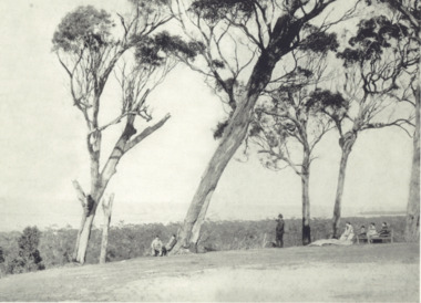
Black and white photograph taken from Roadknights Merrangbaur property looking towards the natural entrance, seven people sitting or standing on brow of hill Lakes Entrance Victoria. Also a colour photograph taken from Merrangbaur hill of warm holes and dunes and ocean approximate site of original entrance taken in 1995 historic site, topography, ocean -
 Orbost & District Historical Society
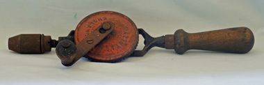
hand drill
The invention of a hand drill is credited to Arthur James Arnot and William Blanch Brain of Melbourne, Australia who patented the electric drill in 1889. In 1895, the first portable handheld drill was created by brothers Wilhem & Carl Fein of Stuttgart, Germany. Hand-powered devices have been used for millennia. However, during the last quarter of the 19th century a radically improved generation of tools appeared. These tools took advantage of modern mass production machinery and processes (like interchangeable parts) and an increased availability in superior material (metal instead of wood). One of the outcomes included an array of new drilling machines. These human-powered tools were a vast improvement over earlier tools.This item is an example of a commonly used domestic tool - pre power tools.A Stanley hand drill with two wooden handles. The red wheel is painted metal. On red wheel - STANLEY ENGLANDwoodwork tool hand-drill -
 Whitehorse Historical Society Inc.
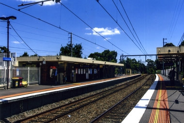
Photograph, Blackburn Railway Station, 2012
In 1882 the railway from Melbourne to Camberwell was extended to Lilydale, Blackburn Station was then known as Blackburn Greek Station and was opened on 2 December 1882. At this time the Lilydale line had only a single track. On 12 August 1889 Blackburn was designated as a 'crossing station' as it had 2 platforms. In 1891 a second line was added between Box Hill and Ringwood stations. Service termination at Blackburn began in the late 1890's due to the large number of passengers visiting the Blackburn Lake Sanctuary. The Lilydale line was electrified to Ringwood in January 1923. Automatic signalling reached Blackburn in 19568. Boom gates replaced hand gates in 1970. in 1980, the goods siding was removed and the old station was demolished.Coloured photograph of the south side of the Blackburn Station. People using this platform are headed towards the city - 2012blackburn railway station -
 Kew Historical Society Inc
Photograph, Floods in North Kew, 1971
Living with natural processes was frequently a challenge to early European settlers and later residents of what was in the 1850s administered by the Borondara Road Board. This was compounded by the area being bounded on three sides by rivers (Yarra River, Koonung Creek and Gardiner's Creek). In 1849, the historian James Bonwick recorded that "our district [Kew] suffered considerably. Mr Wade speaks of 80 acres, out of 100 acres of his cultivated paddock, covered by water." Newspapers continued to describe major flooding in Kew in 1863, 1869, 1878, 1880, 1889, 1891, 1916 and 1934. While the construction of the Upper Yarra dam in 1957 reduced the levels of flowing downstream, local and riverine floods continue.The Kew Historical Society's pictures and map collections testify to the impact of flooding in the district. They have historical importance in documenting the extent of flooding in the district and its affects on homes, services and recreation. Numerous photographs record flooding throughout the Twentieth Century.Floods in North Kew, 1971. Looking northeast towards Kilby Road from River Avenue. Annotation on reverse: map and date "8 Nov. 71 10.30am".floods (kew), yarra river, kew flood, kilby road flood -
 Kew Historical Society Inc
Photograph, Floods in North Kew, 1934
Living with natural processes was frequently a challenge to early European settlers and later residents of what was in the 1850s administered by the Borondara Road Board. This was compounded by the area being bounded on three sides by rivers (Yarra River, Koonung Creek and Gardiner's Creek). In 1849, the historian James Bonwick recorded that "our district [Kew] suffered considerably. Mr Wade speaks of 80 acres, out of 100 acres of his cultivated paddock, covered by water." Newspapers continued to describe major flooding in Kew in 1863, 1869, 1878, 1880, 1889, 1891, 1916 and 1934. While the construction of the Upper Yarra dam in 1957 reduced the levels of flowing downstream, local and riverine floods continue.The Kew Historical Society's pictures and map collections testify to the impact of flooding in the district. They have historical importance in documenting the extent of flooding in the district and its affects on homes, services and recreation. Numerous photographs record flooding throughout the Twentieth Century.Floods in North Kew, 1934. Vicinity of Willsmere Park.floods (kew) -
![Flooding at Chipperfield's Boathouse [East Kew], 1934](/media/collectors/550653872162f11fb04854aa/items/58cbaad5d0cec425b474bfb1/item-media/58cf6fbdd0cf9f331490feb0/item-fit-380x285.jpg) Kew Historical Society Inc
Kew Historical Society IncPhotograph, Flooding at Chipperfield's Boathouse, 1934
Living with natural processes was frequently a challenge to early European settlers and later residents of what was in the 1850s administered by the Borondara Road Board. This was compounded by the area being bounded on three sides by rivers (Yarra River, Koonung Creek and Gardiner's Creek). In 1849, the historian James Bonwick recorded that "our district [Kew] suffered considerably. Mr Wade speaks of 80 acres, out of 100 acres of his cultivated paddock, covered by water." Newspapers continued to describe major flooding in Kew in 1863, 1869, 1878, 1880, 1889, 1891, 1916 and 1934. While the construction of the Upper Yarra dam in 1957 reduced the levels of flowing downstream, local and riverine floods continue.The Kew Historical Society's pictures and map collections testify to the impact of flooding in the district. They have historical importance in documenting the extent of flooding in the district and its affects on homes, services and recreation. Numerous photographs record flooding throughout the Twentieth Century.Floods in North Kew, 1934. Chipperfield's Boathouse and the adding Moorings was located beside the Yarra River near the corner of Willsmere and Kilby Roads. The flood reached the roof of the Moorings, which can be seen in the photo.floods (kew), floods (kew) 1934, yarra river -
 Kew Historical Society Inc
Photograph, Floods in North Kew, 1934
Living with natural processes was frequently a challenge to early European settlers and later residents of what was in the 1850s administered by the Borondara Road Board. This was compounded by the area being bounded on three sides by rivers (Yarra River, Koonung Creek and Gardiner's Creek). In 1849, the historian James Bonwick recorded that "our district [Kew] suffered considerably. Mr Wade speaks of 80 acres, out of 100 acres of his cultivated paddock, covered by water." Newspapers continued to describe major flooding in Kew in 1863, 1869, 1878, 1880, 1889, 1891, 1916 and 1934. While the construction of the Upper Yarra dam in 1957 reduced the levels of flowing downstream, local and riverine floods continue.The Kew Historical Society's pictures and map collections testify to the impact of flooding in the district. They have historical importance in documenting the extent of flooding in the district and its affects on homes, services and recreation. Numerous photographs record flooding throughout the Twentieth Century.Floods in North Kew, 1934. Unidentified location on the Yarra Flood Plain at Kew.floods (kew) 1934, yarra river -
 Kew Historical Society Inc
Photograph, Floods in North Kew, 1934
Living with natural processes was frequently a challenge to early European settlers and later residents of what was in the 1850s administered by the Borondara Road Board. This was compounded by the area being bounded on three sides by rivers (Yarra River, Koonung Creek and Gardiner's Creek). In 1849, the historian James Bonwick recorded that "our district [Kew] suffered considerably. Mr Wade speaks of 80 acres, out of 100 acres of his cultivated paddock, covered by water." Newspapers continued to describe major flooding in Kew in 1863, 1869, 1878, 1880, 1889, 1891, 1916 and 1934. While the construction of the Upper Yarra dam in 1957 reduced the levels of flowing downstream, local and riverine floods continue.The Kew Historical Society's pictures and map collections testify to the impact of flooding in the district. They have historical importance in documenting the extent of flooding in the district and its affects on homes, services and recreation. Numerous photographs record flooding throughout the Twentieth Century.Floods in North Kew, 1934. Chipperfield's Boat House under flood.floods (kew) 1934, yarra river, chipperfield's boat house -
 Kew Historical Society Inc
Photograph, Floods in North Kew, 1934
Living with natural processes was frequently a challenge to early European settlers and later residents of what was in the 1850s administered by the Borondara Road Board. This was compounded by the area being bounded on three sides by rivers (Yarra River, Koonung Creek and Gardiner's Creek). In 1849, the historian James Bonwick recorded that "our district [Kew] suffered considerably. Mr Wade speaks of 80 acres, out of 100 acres of his cultivated paddock, covered by water." Newspapers continued to describe major flooding in Kew in 1863, 1869, 1878, 1880, 1889, 1891, 1916 and 1934. While the construction of the Upper Yarra dam in 1957 reduced the levels of flowing downstream, local and riverine floods continue.The Kew Historical Society's pictures and map collections testify to the impact of flooding in the district. They have historical importance in documenting the extent of flooding in the district and its affects on homes, services and recreation. Numerous photographs record flooding throughout the Twentieth Century.Floods in North Kew, 1934. Flood near the lagoon (Billabong?)floods (kew) 1934, yarra river -
 Linton and District Historical Society Inc
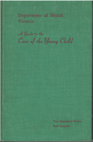
Textbook written by Dr Vera Scantlebury, A Guide to the Care of the Young Child, 1958
Vera Scantlebury Brown was born in Linton in 1889, a daughter of Dr George Scantlebury and his wife Catherine, née Baynes. Vera undertook medical training at Melbourne University between 1907 and 1913. After serving in the British Army Medical Unit during World War I, she worked in various positions in Melbourne hospitals and then studied in the US and Canada. In 1926 she was appointed Director of Infant Welfare by the recently established Victorian Department of Health, and became responsible for the development of maternal, infant and pre-school services in Victoria. In 2023 a statue of Vera Scantlebury was erected in Linton's Avenue of Honour in Denison Street. This copy of the book appears to have been owned/used by Barbara Safstrom of Linton.Textbook for nursing students and other health professionals. First compiled by Dr Vera Scantlebury Brown and published as a "Guide to Infant Feeding". Book revised (with Kate Campbell) in 1941, 1951 and 1958. Pages 346 p.: index, tables.Inscribed top right of front endpaper: 'Barbara Saftstrom / FF8269'.vera scantlebury, kate campbell, 'a guide to the care of the young child' [textbook] -
 The Beechworth Burke Museum Research Collection
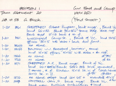
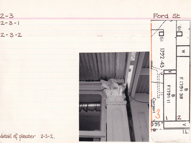
Card (Series) - Index Card, George Tibbits, Cnr Ford and Camp Streets (Ford St), Beechworth, 1976
George Tibbits, University of Melbourne. Faculty of Architecture, Building and Town & Regional PlanningIndex system that support the research for Beechworth : historical reconstruction / [by] George Tibbits ... [et al]Arranged by street names of BeechworthEach index card includes: street name and number of property, image of property, allotment and section number, property owners and dates of ownership, description of the property according to rate records, property floor plan with dimensions.beechworth, george tibbitsbeechworth, george tibbits -
 The Beechworth Burke Museum Research Collection
Card (Series) - Index Card, George Tibbits, Ford Street, Beechworth, 1976
George Tibbits, University of Melbourne. Faculty of Architecture, Building and Town & Regional PlanningIndex system that support the research for Beechworth : historical reconstruction / [by] George Tibbits ... [et al]Arranged by street names of BeechworthEach index card includes: street name and number of property, image of property, allotment and section number, property owners and dates of ownership, description of the property according to rate records, property floor plan with dimensions.beechworth, george tibbitsbeechworth, george tibbits -
 Orbost & District Historical Society
Photograph, December 1892
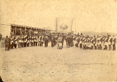
The Commercial Hotel is now the Delegate Hotel (after 1927). This photograph of the Orbost Brass Band and the Delegate Lodge of UIOOF was presented to the bandmaster by the secretary of the Lodge when the Orbost band went to Delegate to entertain them. They travelled by horseback to play for the Star of Delegate Order of Oddfellows. The first Orbost Brass Band was formed in 1889. Around 1908 the town band split and the Orbost Workers' Band was formed. Eventually the two bands merged in 1913 to reform as the Orbost Municipal Band under conductorship of Charles Spink. The band continued for many years but was later disbanded and again reformed. This was to happen a number of times, the last time being in 1961 and continuing through to the late 1970's. Further info and Ref: In Times Gone By - Deborah Hall This is a pictorial record of the Orbost Brass Band. The various Orbost bands over the years played a major role in community activities providing entertainment and musical experiences for the many members.A yellowed photograph on a white buff card with band members and their instruments. They are standing underneath a large sign with lodge members, wearing Lodge regalia, in a line on each side. In the background is the verandah of a hotel - The Commercial.on back - "Presented to Mr C. Spink, bandmaster Orbost Brass Band, by the members of the ??? Delegate Lodge of IOOF"orbost brass band, orbost workers'band, ioof, independent order of odd fellows, charles spink, 1892 -
 Warrnambool and District Historical Society Inc.
Ephemera - Serviette Warrnambool Football Club dinner 1933, 1933
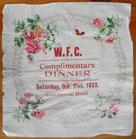
Warrnambool Football Club was formed in June 1861 making it one of the earliest clubs formed in Australia and many of the earliest players and associates were members also of the Warrnambool Cricket club which was established around 1854. Games of various sized teams were played in the early years and it was in 1889 that the Warrnambool and District Football Association was formed. The year marked with the celebration of this dinner, was important in the club’s history as it marked their entry into the wider Hampden football league, where it still plays to the present day. As the venue for this dinner, the Commercial Hotel on the corner of Liebig and Timor Sts, was commonly used in the early days as a club meeting place. The history of the club was recorded in “The Birth of the Blues” by Ron Cole, Harry Keilar, Ron McCorkell and Ian Wright, in 2007.The Warrnambool Football club is one of the longest surviving sporting clubs in the Warrnambool district and as such, would have involved or touched the lives of many of its residents. This serviette marks a dinner which was an important event in the history of the Warrnambool Football Club. White crepe paper with circular bell pattern, which has been embellished in each corner with pink flowers and green leaves. Centre of circle printed in large red lettering.WFC Complimentary Dinner Saturday Oct. 21st 1933 Commercial hotel.warrnambool, warrnambool football club, wfc dinner 1933, commercial hotel 1933, commercial hotel -
 Warrnambool and District Historical Society Inc.
Document - Ann Doran Letters of Administration 1911, 1911
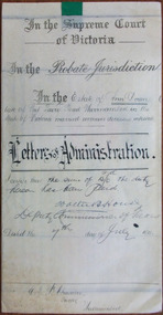
Tait collection: item 30 of 62 This document contains information on the Letters of Administration of Ann Doran of Port Fairy Road, Warrnambool. She died in December 1889 but, as she died intestate, the Letters of Administration were not processed until 1911. Ann Doran left no real estate but left personal estate to the value of £116. The sole beneficiary was her daughter, Jane Doran. The lawyer in the case was Ernest Chambers who had legal offices in Port Fairy, Warrnambool and Koroit at the end of the 19th century and the beginning of the 20th century. He had this document in his possession and it was passed down to successive lawyers occupying the legal premises in Kepler Street. It was located in this building in 2014 and passed on to the Warrnambool and District Historical Society at that time. This document is of some interest as it contains information on the Letters of Administration of Ann Doran who lived in Warrnambool at the time of her death in 1889. It will be of use to researchers. This is a cream-coloured piece of parchment paper folded in two with handwritten material on two sides. One page has ruled black lines. A seal of the Supreme Court of Victoria is attached with a green ribbon and there are four red stamps of the Master in Equity of the Supreme Court. One page is somewhat stained.In the Supreme Court of Victoria; In the Probate Jurisdiction; In the Estate of Ann Doran late of Port Fairy Road Warrnambool in the State of Victoria married woman deceased intestate. Letters of Administration.ann doran, ernest chambers, warrnambool -
 Uniting Church Archives - Synod of Victoria
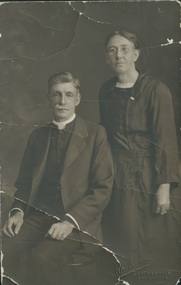
Photograph, Undated c.1920
James Rogers was born in Wallaroo, South Australia, but came to Sailor's Gully, Eaglehawk with his family as an infant. He was converted in a Salvation Army meeting at Bendigo. He became a member of the Primitive Methodist Church at Eaglehawk. He was stationed at: 1888 Murtoa; 1889 Hamilton; 1892 Melbourne, Collingwood; 1892 Beaconsfield; 1894 Penguin; 1900 Castlemaine; 1905 Dimboola; 1909 Geelong, Yarra St.; 1913 Kilcunda & Powlett River; 1917 Kyabram; 1920 North Melbourne; 1923 Brighton; 1928 Prahran; 1932 Supernumerary Hawthorn. Gaol Chaplain 1909 - 1912; Hospital Chaplain 1935 - 1936Died 2nd September 1937 Agnes Rogers (nee Caldwell) was born in 1867, married James Rogers in 1892 and died in 1951.B & W studio portrait of Rev James Rogers and Mrs Agnes Rogers (nee Caldwell)james rogers, agnes rogers, agnes caldwell, methodist, primitive methodist, eaglehawk, minister -
 Surrey Hills Historical Society Collection
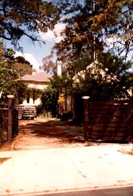
Photograph, Rear of Varndean from Willcyrus Street, 1988, 1988
Ref: Alan Holt records - This property has had a number of different names throughout its history. William Cook, a farmer, bought the land it stands on in 1876. In 1882 he was rated for a house (not the current one) on 11 acres. The present house was built in 1885 by John Clark, an auctioneer. In 1888 the Tower Hill estate and the home (Tower Hill Lodge) were auctioned, but the house was not sold. In 1889 the house was purchased by Captain Shepherd. Records show that in 1894 the owners were Mr Thomas and Mrs Hortenzia Howell. They named the house 'Corcovado'. Later they added a study with a corner designed to provide views from the Dandenong Ranges around to Mt Macedon. In 1944 Mr and Mrs Lionel Adams renamed the house 'Varndean'.This is one of the earliest surviving houses in Surrey Hills.A colour photo taken from the street at the rear of a Victorian-style house with ornate chimneys and a slate roof. A parked car is seen in front of the house. The house sits behind a timber fence and is partly hidden by mature shrubs and trees.victorian style, tower hill lodge, corcovado, varndean, tower hill estate, mr william cook, mr john clark, mrs hortenzia howell, mr lionel adams, mrs lionel adams, surrey hills, captain louis shepherd, mr thomas howell