Showing 3572 items matching " environment"
-
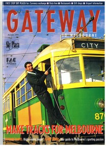 Melbourne Tram Museum
Magazine, Michael Davie, "Gateway - Autumn 1995", "The Lucky City", 1995
Autumn 1995 issue of Gateway with a trammie (Roberto D'Andrea) leaning from 870 on the front cover. Contains an article "The Lucky City", written by Michael Davie about Melbourne and its city, in particular its trams. Has a photo of a City Circle tram (866) on page 22. Gateway published the Federal Airports Corporation as an inbound magazine for overseas travellers. In an email from Roberto 2/10/2014 - "G'day Warren, Yes indeed the Gateway Magazine with a younger Roberto at South Depot. Brings to mind that South Depot did the bulk of the tramways media through the 90s until closure. On the list of programs I have in the archive is Totally Wild (Channel 10), Monty the Weatherman did 4 crosses live (Channel 9), 7.30 Reports (ABC), we hosted 4 Corners around the network and a few other programs on Channel 7. Plenty of newspapers and radio. Handy with a close to city location the PTC sent the media to South for tram stories. I have the 6 Trammie banners from the Trammies Exhibition at the Immigration Museum where we worked together back in 2003. I've used them occasionally and may need them for a tram presentation in March next year....would they be handy as a part of a exhibit at Hawthorn? The Connies are still going strong....festivals and events, sometimes in schools and we've co-funded 2 tram festivals in Kolkata with the Calcutta Tramways in 2012 and 2013....environment central to the themes. Kevin keeps me posted on how things are going at Hawthorn. I met Doug Prosser at Hawthorn a few months ago and all looking good. Kevin sends me copies of The Bellcord....and just last week I was on the Hawthorn Museum website reading about the Box Hill - Doncaster Tram for a Connie performance in Box Hill late in November. Regards - Roberto www.connies.com.au www.tramconductors.net www.tramjatra.net"trams, tramways, city circle, melbourne, tramways, tram 870, tram 866 -
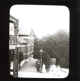 The Beechworth Burke Museum
Photograph - Lantern Slide, c1900
This image appears to show nurses at what is now the Mayday Hills Mental Asylum arriving for work in approximately 1900. These individuals are part of a long history of nursing in Beechworth. Three medical or social welfare facilities opened in the mid-1800s as part of a push by the township to become a regional centre for Government services. These were the Ovens District Hospital (opened in 1857), the Ovens Benevolent Asylum (opened in 1863), and the Beechworth Mental Hospital (opened in 1867 and renamed Mayday Hills Hospital at Centenary celebrations in 1967). It was recognised that the unsettled living conditions, poverty and relative isolation of the Goldfields environment could produce 'mental disturbances' which required local treatment facilities as services in Melbourne were too far away. Carole Woods' publication 'A Titan's Field' describes activities undertaken by patients at Beechworth Mental Hospital as including monthly balls and occasional concerts as well as work to make the facility self-supporting such as farm work and making clothes. She mentions a report in 1870 that the approximately 300 patients were clean and neat with 'no-one in restraint or seclusion' but that by 1905 the organisation had 623 patients which placed strain on building infrastructure such as heating and water supplies, leading to high turnover of nurses and other issues. A program of building works to extend and improve facilities followed over subsequent decades. Lantern slides, sometimes called 'magic lantern' slides, are glass plates on which an image has been secured for the purpose of projection. Glass slides were etched or hand-painted for this purpose from the Eighteenth Century but the process became more popular and accessible to the public with the development of photographic-emulsion slides used with a 'Magic Lantern' device in the mid-Nineteenth Century. Photographic lantern slides comprise a double-negative emulsion layer (forming a positive image) between thin glass plates that are bound together. A number of processes existed to form and bind the emulsion layer to the base plate, including the albumen, wet plate collodion, gelatine dry plate and Woodburytype techniques. Lantern slides and magic lantern technologies are seen as foundational precursors to the development of modern photography and film-making techniques This glass slide is significant because it provides insight into Beechworth's social and medical amenities in the early Twentieth Century, around the time of Australia's Federation into one nation. It is also an example of an early photographic and film-making technology in use in regional Victoria in the time period.Thin translucent sheet of glass with a rectangular image printed on the front and framed in a black backing. It is held together by metals strips to secure the edges of the slide.Obverse: i /burke museum, beechworth, lantern slide, slide, glass slide, plate, burke museum collection, photograph, monochrome, magic lantern, indigo shire, north-east victoria, nineteenth century, 1900s, twentieth century, emulsion slides, nursing, nurses, mental hospitals, lunatic asylums, asylums, social services, social welfare, insane asylums, mental health, infrastructure -
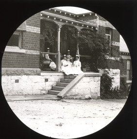 The Beechworth Burke Museum
Photograph - Lantern Slide, c1900
This image appears to show nurses at what is now the Mayday Hills Mental Asylum in approximately 1900. These individuals are part of a long history of nursing in Beechworth. Three medical or social welfare facilities opened in the mid-1800s as part of a push by the township to become a regional centre for Government services. These were the Ovens District Hospital (opened in 1857), the Ovens Benevolent Asylum (opened in 1863), and the Beechworth Mental Hospital (opened in 1867 and renamed Mayday Hills Hospital at Centenary celebrations in 1967). It was recognised that the unsettled living conditions, poverty and relative isolation of the Goldfields environment could produce 'mental disturbances' which required local treatment facilities as services in Melbourne were too far away. Carole Woods' publication 'A Titan's Field' describes activities undertaken by patients at Beechworth Mental Hospital as including monthly balls and occasional concerts as well as work to make the facility self-supporting such as farm work and making clothes. She mentions a report in 1870 that the approximately 300 patients were clean and neat with 'no-one in restraint or seclusion' but that by 1905 the organisation had 623 patients which placed strain on building infrastructure such as heating and water supplies, leading to high turnover of nurses and other issues. A program of building works to extend and improve facilities followed over subsequent decades. Lantern slides, sometimes called 'magic lantern' slides, are glass plates on which an image has been secured for the purpose of projection. Glass slides were etched or hand-painted for this purpose from the Eighteenth Century but the process became more popular and accessible to the public with the development of photographic-emulsion slides used with a 'Magic Lantern' device in the mid-Nineteenth Century. Photographic lantern slides comprise a double-negative emulsion layer (forming a positive image) between thin glass plates that are bound together. A number of processes existed to form and bind the emulsion layer to the base plate, including the albumen, wet plate collodion, gelatine dry plate and Woodburytype techniques. Lantern slides and magic lantern technologies are seen as foundational precursors to the development of modern photography and film-making techniques.This glass slide is significant because it provides insight into Beechworth's social and medical amenities in the early Twentieth Century, around the time of Australia's Federation into one nation. It is also an example of an early photographic and film-making technology in use in regional Victoria in the time period.Thin translucent sheet of glass with a circular image printed on the front and framed in a black backing. It is held together by metals strips to secure the edges of the slide.burke museum, beechworth, lantern slide, slide, glass slide, plate, burke museum collection, photograph, monochrome, magic lantern, indigo shire, north-east victoria, nineteenth century, 1900s, twentieth century, emulsion slides, nursing, nurses, mental hospitals, lunatic asylums, asylums, social services, social welfare, insane asylums, mental health, infrastructure -
 Eltham District Historical Society Inc
Document - Newspaper clipping, "The lap of luxury; Blending into Eltham environ", Property Age, The Age, Wednesday 24 June 1998, p5, June 1998
Both of the architects involved in the 2.4-hectare Kinloch Gardens parkland development in Arthur Street, Eltham, are now living on the estate. The project was conceived by Eltham architect Ian Jelbart, whose family has owned the land for more than 100 years, and fellow architect Graeme Gunn, who in the 1960s was one of the creators of the Merchants Builders concept that set new trends in Melbourne housing. The $5 million project is based around two of the original buildings, on what was once a 100-hectare farm owned by the Jelbart family. Ian Jelbart always intended to continue living in the original homestead building, and now Graeme Gunn has moved into the big residence that once was the barn. Kinloch Gardens is designed to combine the more manageable land sizes increasingly demanded by buyers with ample "internal space, flexible floorplans, privacy and individuality of designs. Individual houses are placed on small separate allotments around an area of private parkland. The aim is to ensure total privacy, offer virtually unlimited views and parkland vistas, and remain aesthetically compatible with the local environment. Homes in four basic designs over either two or three levels are being sold off the plan, with prices ranging from the high $200,000s to the high $300,000s. Two have already been sold. Indication of land-only values The prices being asked for some vacant blocks offered for private sale provides an enlightening comparison of the relative "land only" values for homes sites in various areas. A 751 sq metre block on a new residential estate in Bentleigh/Carnegie is offered at $235,000, equivalent to $312/square metre; while in Merrett Drive, Williamstown, a 561 sq metre allotment offered for $169,000 carries a rate of $301/sq metre. In Barnsbury Road, Balwyn, the $450,000 price tag on a 584 sq metre allotment equates to $770 sq metre; and in York Street, Richmond, a 198 sq metre postage stamp is priced at $230,000 or $1162/sq metre. - Rex BookerDigital file only; created from scan undertaken by EDHS of item on loanarthur street, eltham, graeme gunn, houses, ian jelbart, jelbart property, kinloch gardens, rob maclellan, robert marshall, woodridge estate -
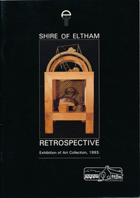 Eltham District Historical Society Inc
Book, Shire of Eltham Retrospective exhibition of art collection, 1993, 1993
Contents: List of illustrations, From the Shire President, Historical background, current perspective and catalogue of art collection. This includes over 100 items. Book produced to accompany exhibition held at the Eltham Community and Reception Centre, Main Road Eltham June 26 - July 4 1993. "This exhibition celebrates two aspects of the art collection of the Shire of Eltham. There is the work which shows the love of Eltham and the environment, and work which deals with much broader concerns" Artists include: Helen Aitken-Kuhnen, David Armfield, Brian Armstrong, Alan Baker, Yvonne Ball, Piers Bateman, Julie Begg, Judith Ben-Meir, Yvonne Birch, The Bodford Collection, Janet Boddy, Deidre Boeyen, Ian Bow, David Benchley, Don Brown, Gilbert Buchanan, Paul Cavell, Patty Chandler, Rosalie Cogan, Scott Joseph Cowcher, Augustine Dall'Ava, Greg Daly, Simon Dattner, Peter Day, Domenico de Clario, Robert Delves, Joh Ebeli, Mark Edgoose, Graham Fransella, Ernest Fries, Edward Ginger, Peter Glass, Drew Gregory, Alison Hann, Tony Harkin, Wendy Henderson, Stephen Hughes, Lindsay Imbandarinja, John Irving, Hilary Jackman, Jill Kahans, William Kelly, Margot Knox, Margot Kroyer-Pederson, Anne Kueffer, Bruno Leti, Kevin Lincoln, Paul Margocsy, Alan Martin, Barry Mills, Simon Barley, Jenni Mitchell, David Moore, Barbara Munro, Ewald Namatjira, Norma Neil, Mark Page, Herman Pekel, Shane Pickett, Anthony Pryor, Clifton Pugh, Lynn Quintal, Giuseppe Raneri, Ken Robb, John Serle, Marjorie Shattock, Leslie Sinclair, Matcham Skipper, Myra Skipper, Sonia Skipper, Harris Smith, Eric Stephenson, Adriane Strampp, Marian Sussex, Tony Trembath, George Turcu, John Wakefield, Peter Wallace, Ray Walsh, Michael Wilson, Walter Withers, Vic Wood, Doug Wright, Romana Favier Zorzut, Renier Zusters.Softcover . Includes separate sheet of paper printed on both sides: "catalogue supplement" and "errata"shire of eltham art collection -
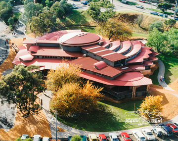
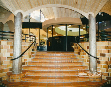
 Eltham District Historical Society Inc
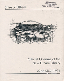
Photo album, Official Opening of the New Eltham Library, 22nd May,1994, 1994
Library Development The library building has been designed to reflect its parkland setting. External features include: the roof which includes interesting aspects when viewed from Main Road; verandahs which provide ramp access and give a sheltered entrance to the building; walls which feature locally-made mudbricks, conventional bricks and copper panels; and space for an outdoor courtyard/reading area which will be developed later. Internally there are a number of features. The building includes a foyer with a fireplace suitable for displays including artwork; a community multi-purpose room suitable for meetings or functions and an outdoor cafeteria. The ceilings are lined with Victorian Ash. The shapes for the ceiling give a free flowing form to the building. Brush Box has been used for the circulation and information desks. The tree trunk columns are Grey lronbark from New South Wales. Arches and and various-shaped windows add interest to the internal structure. The carpet design reflects the Eltham environment and compliments the natural colours and timbers used in the building. Tiles by artist Felix Bosari feature in the building and additional art by local artists will be added externally and internally to the building. The library floor area is approximately 1200 sq metres and houses a collection of 50,000 items. The community multi-purpose room, foyer and community display area totals approximately 300 sq metres. These areas will be available to the community for such events a~ meetings, displays, classes, functions and art exhibitions. The Toy Library and Adult Literacy Group will also be based in the new complex. The value of works/services and fittings/ furniture is $3,040,000 Project Team Project Director: John Stamp, Director - Major Projects Project Manager: Noel Mcinnes, Noel Mcinnes Project Management Pty Ltd Architects: Gregory Burgess and Peter Ryan, Gregory Burgess Pty Ltd Site Foreman - Building Works: John Mantel Site Foreman - Site Works and Foundations: Steven White, Shire of Eltham Surveyor: Gregory Slater, Shire of Eltham Builder: Shire of ElthamPhoto album of the new Eltham Library presented to the Society by Cr R.J. Manuell, Chairperson Eltham Library Redevelopment Special Committee, 28 Nov 1994 in recognition of the efforts and contribution made by the Shire of Eltham Historical Society to the construction of the Eltham Library complex.Black faux leather album cover, black pages, brass corners and screws, 10 page inserts separated by tissue, 12 photos and information sheets stuck to pages.eltham, eltham library, panther place, shire of eltham, yarra plenty regional library -
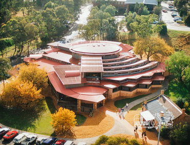
 Eltham District Historical Society Inc
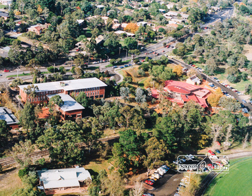
Photo album, Aerial view showing the Shire of Eltham office, new Eltham Library and relocated Shillinglaw Cottage, 1994, 1994
Library Development The library building has been designed to reflect its parkland setting. External features include: the roof which includes interesting aspects when viewed from Main Road; verandahs which provide ramp access and give a sheltered entrance to the building; walls which feature locally-made mudbricks, conventional bricks and copper panels; and space for an outdoor courtyard/reading area which will be developed later. Internally there are a number of features. The building includes a foyer with a fireplace suitable for displays including artwork; a community multi-purpose room suitable for meetings or functions and an outdoor cafeteria. The ceilings are lined with Victorian Ash. The shapes for the ceiling give a free flowing form to the building. Brush Box has been used for the circulation and information desks. The tree trunk columns are Grey lronbark from New South Wales. Arches and and various-shaped windows add interest to the internal structure. The carpet design reflects the Eltham environment and compliments the natural colours and timbers used in the building. Tiles by artist Felix Bosari feature in the building and additional art by local artists will be added externally and internally to the building. The library floor area is approximately 1200 sq metres and houses a collection of 50,000 items. The community multi-purpose room, foyer and community display area totals approximately 300 sq metres. These areas will be available to the community for such events a~ meetings, displays, classes, functions and art exhibitions. The Toy Library and Adult Literacy Group will also be based in the new complex. The value of works/services and fittings/ furniture is $3,040,000 Project Team Project Director: John Stamp, Director - Major Projects Project Manager: Noel Mcinnes, Noel Mcinnes Project Management Pty Ltd Architects: Gregory Burgess and Peter Ryan, Gregory Burgess Pty Ltd Site Foreman - Building Works: John Mantel Site Foreman - Site Works and Foundations: Steven White, Shire of Eltham Surveyor: Gregory Slater, Shire of Eltham Builder: Shire of ElthamShows the relationship of the the Shire of Eltham office which was built on the original location of Shillinglaw Cottage and relocated to Panther Place.The Shillinglaw trees visible, still in their original location, in front of the Shire offices. Photo album of the new Eltham Library presented to the Society by Cr R.J. Manuell, Chairperson Eltham Library Redevelopment Special Committee, 28 Nov 1994 in recognition of the efforts and contribution made by the Shire of Eltham Historical Society to the construction of the Eltham Library complex.Black faux leather album cover, black pages, brass corners and screws, 10 page inserts separated by tissue, 12 photos and information sheets stuck to pages.eltham, eltham library, panther place, shire of eltham, yarra plenty regional library, shillinglaw cottage -
 Eltham District Historical Society Inc
Photo album, Aerial view showing the new Eltham Library and relocated Shillinglaw Cottage, 1994, 1994
Library Development The library building has been designed to reflect its parkland setting. External features include: the roof which includes interesting aspects when viewed from Main Road; verandahs which provide ramp access and give a sheltered entrance to the building; walls which feature locally-made mudbricks, conventional bricks and copper panels; and space for an outdoor courtyard/reading area which will be developed later. Internally there are a number of features. The building includes a foyer with a fireplace suitable for displays including artwork; a community multi-purpose room suitable for meetings or functions and an outdoor cafeteria. The ceilings are lined with Victorian Ash. The shapes for the ceiling give a free flowing form to the building. Brush Box has been used for the circulation and information desks. The tree trunk columns are Grey lronbark from New South Wales. Arches and and various-shaped windows add interest to the internal structure. The carpet design reflects the Eltham environment and compliments the natural colours and timbers used in the building. Tiles by artist Felix Bosari feature in the building and additional art by local artists will be added externally and internally to the building. The library floor area is approximately 1200 sq metres and houses a collection of 50,000 items. The community multi-purpose room, foyer and community display area totals approximately 300 sq metres. These areas will be available to the community for such events a~ meetings, displays, classes, functions and art exhibitions. The Toy Library and Adult Literacy Group will also be based in the new complex. The value of works/services and fittings/ furniture is $3,040,000 Project Team Project Director: John Stamp, Director - Major Projects Project Manager: Noel Mcinnes, Noel Mcinnes Project Management Pty Ltd Architects: Gregory Burgess and Peter Ryan, Gregory Burgess Pty Ltd Site Foreman - Building Works: John Mantel Site Foreman - Site Works and Foundations: Steven White, Shire of Eltham Surveyor: Gregory Slater, Shire of Eltham Builder: Shire of ElthamPhoto album of the new Eltham Library presented to the Society by Cr R.J. Manuell, Chairperson Eltham Library Redevelopment Special Committee, 28 Nov 1994 in recognition of the efforts and contribution made by the Shire of Eltham Historical Society to the construction of the Eltham Library complex.Black faux leather album cover, black pages, brass corners and screws, 10 page inserts separated by tissue, 12 photos and information sheets stuck to pages.eltham, eltham library, panther place, shire of eltham, yarra plenty regional library, shillinglaw cottage -
 Eltham District Historical Society Inc
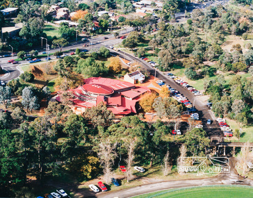
Photo album, Aerial view showing the new Eltham Library, 1994, 1994
Library Development The library building has been designed to reflect its parkland setting. External features include: the roof which includes interesting aspects when viewed from Main Road; verandahs which provide ramp access and give a sheltered entrance to the building; walls which feature locally-made mudbricks, conventional bricks and copper panels; and space for an outdoor courtyard/reading area which will be developed later. Internally there are a number of features. The building includes a foyer with a fireplace suitable for displays including artwork; a community multi-purpose room suitable for meetings or functions and an outdoor cafeteria. The ceilings are lined with Victorian Ash. The shapes for the ceiling give a free flowing form to the building. Brush Box has been used for the circulation and information desks. The tree trunk columns are Grey lronbark from New South Wales. Arches and and various-shaped windows add interest to the internal structure. The carpet design reflects the Eltham environment and compliments the natural colours and timbers used in the building. Tiles by artist Felix Bosari feature in the building and additional art by local artists will be added externally and internally to the building. The library floor area is approximately 1200 sq metres and houses a collection of 50,000 items. The community multi-purpose room, foyer and community display area totals approximately 300 sq metres. These areas will be available to the community for such events a~ meetings, displays, classes, functions and art exhibitions. The Toy Library and Adult Literacy Group will also be based in the new complex. The value of works/services and fittings/ furniture is $3,040,000 Project Team Project Director: John Stamp, Director - Major Projects Project Manager: Noel Mcinnes, Noel Mcinnes Project Management Pty Ltd Architects: Gregory Burgess and Peter Ryan, Gregory Burgess Pty Ltd Site Foreman - Building Works: John Mantel Site Foreman - Site Works and Foundations: Steven White, Shire of Eltham Surveyor: Gregory Slater, Shire of Eltham Builder: Shire of ElthamPhoto album of the new Eltham Library presented to the Society by Cr R.J. Manuell, Chairperson Eltham Library Redevelopment Special Committee, 28 Nov 1994 in recognition of the efforts and contribution made by the Shire of Eltham Historical Society to the construction of the Eltham Library complex.Black faux leather album cover, black pages, brass corners and screws, 10 page inserts separated by tissue, 12 photos and information sheets stuck to pages.eltham, eltham library, panther place, shire of eltham, yarra plenty regional library -
 Eltham District Historical Society Inc
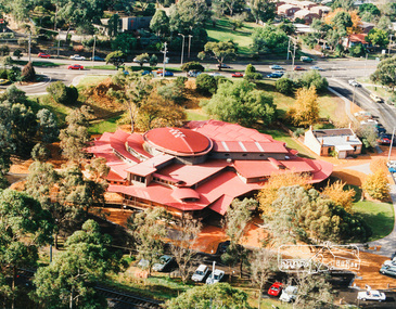
Photo album, Aerial view showing the new Eltham Library, 1994, 1994
Library Development The library building has been designed to reflect its parkland setting. External features include: the roof which includes interesting aspects when viewed from Main Road; verandahs which provide ramp access and give a sheltered entrance to the building; walls which feature locally-made mudbricks, conventional bricks and copper panels; and space for an outdoor courtyard/reading area which will be developed later. Internally there are a number of features. The building includes a foyer with a fireplace suitable for displays including artwork; a community multi-purpose room suitable for meetings or functions and an outdoor cafeteria. The ceilings are lined with Victorian Ash. The shapes for the ceiling give a free flowing form to the building. Brush Box has been used for the circulation and information desks. The tree trunk columns are Grey lronbark from New South Wales. Arches and and various-shaped windows add interest to the internal structure. The carpet design reflects the Eltham environment and compliments the natural colours and timbers used in the building. Tiles by artist Felix Bosari feature in the building and additional art by local artists will be added externally and internally to the building. The library floor area is approximately 1200 sq metres and houses a collection of 50,000 items. The community multi-purpose room, foyer and community display area totals approximately 300 sq metres. These areas will be available to the community for such events a~ meetings, displays, classes, functions and art exhibitions. The Toy Library and Adult Literacy Group will also be based in the new complex. The value of works/services and fittings/ furniture is $3,040,000 Project Team Project Director: John Stamp, Director - Major Projects Project Manager: Noel Mcinnes, Noel Mcinnes Project Management Pty Ltd Architects: Gregory Burgess and Peter Ryan, Gregory Burgess Pty Ltd Site Foreman - Building Works: John Mantel Site Foreman - Site Works and Foundations: Steven White, Shire of Eltham Surveyor: Gregory Slater, Shire of Eltham Builder: Shire of ElthamPhoto album of the new Eltham Library presented to the Society by Cr R.J. Manuell, Chairperson Eltham Library Redevelopment Special Committee, 28 Nov 1994 in recognition of the efforts and contribution made by the Shire of Eltham Historical Society to the construction of the Eltham Library complex.Black faux leather album cover, black pages, brass corners and screws, 10 page inserts separated by tissue, 12 photos and information sheets stuck to pages.eltham, eltham library, panther place, shire of eltham, yarra plenty regional library -
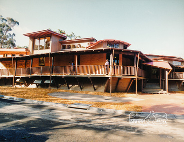 Eltham District Historical Society Inc
Photo album, Exterior view of the new Eltham Library, 1994, 1994
Library Development The library building has been designed to reflect its parkland setting. External features include: the roof which includes interesting aspects when viewed from Main Road; verandahs which provide ramp access and give a sheltered entrance to the building; walls which feature locally-made mudbricks, conventional bricks and copper panels; and space for an outdoor courtyard/reading area which will be developed later. Internally there are a number of features. The building includes a foyer with a fireplace suitable for displays including artwork; a community multi-purpose room suitable for meetings or functions and an outdoor cafeteria. The ceilings are lined with Victorian Ash. The shapes for the ceiling give a free flowing form to the building. Brush Box has been used for the circulation and information desks. The tree trunk columns are Grey lronbark from New South Wales. Arches and and various-shaped windows add interest to the internal structure. The carpet design reflects the Eltham environment and compliments the natural colours and timbers used in the building. Tiles by artist Felix Bosari feature in the building and additional art by local artists will be added externally and internally to the building. The library floor area is approximately 1200 sq metres and houses a collection of 50,000 items. The community multi-purpose room, foyer and community display area totals approximately 300 sq metres. These areas will be available to the community for such events a~ meetings, displays, classes, functions and art exhibitions. The Toy Library and Adult Literacy Group will also be based in the new complex. The value of works/services and fittings/ furniture is $3,040,000 Project Team Project Director: John Stamp, Director - Major Projects Project Manager: Noel Mcinnes, Noel Mcinnes Project Management Pty Ltd Architects: Gregory Burgess and Peter Ryan, Gregory Burgess Pty Ltd Site Foreman - Building Works: John Mantel Site Foreman - Site Works and Foundations: Steven White, Shire of Eltham Surveyor: Gregory Slater, Shire of Eltham Builder: Shire of ElthamPhoto album of the new Eltham Library presented to the Society by Cr R.J. Manuell, Chairperson Eltham Library Redevelopment Special Committee, 28 Nov 1994 in recognition of the efforts and contribution made by the Shire of Eltham Historical Society to the construction of the Eltham Library complex.Black faux leather album cover, black pages, brass corners and screws, 10 page inserts separated by tissue, 12 photos and information sheets stuck to pages.eltham, eltham library, panther place, shire of eltham, yarra plenty regional library -
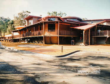 Eltham District Historical Society Inc
Photo album, Exterior view of the new Eltham Library, 1994, 1994
Library Development The library building has been designed to reflect its parkland setting. External features include: the roof which includes interesting aspects when viewed from Main Road; verandahs which provide ramp access and give a sheltered entrance to the building; walls which feature locally-made mudbricks, conventional bricks and copper panels; and space for an outdoor courtyard/reading area which will be developed later. Internally there are a number of features. The building includes a foyer with a fireplace suitable for displays including artwork; a community multi-purpose room suitable for meetings or functions and an outdoor cafeteria. The ceilings are lined with Victorian Ash. The shapes for the ceiling give a free flowing form to the building. Brush Box has been used for the circulation and information desks. The tree trunk columns are Grey lronbark from New South Wales. Arches and and various-shaped windows add interest to the internal structure. The carpet design reflects the Eltham environment and compliments the natural colours and timbers used in the building. Tiles by artist Felix Bosari feature in the building and additional art by local artists will be added externally and internally to the building. The library floor area is approximately 1200 sq metres and houses a collection of 50,000 items. The community multi-purpose room, foyer and community display area totals approximately 300 sq metres. These areas will be available to the community for such events a~ meetings, displays, classes, functions and art exhibitions. The Toy Library and Adult Literacy Group will also be based in the new complex. The value of works/services and fittings/ furniture is $3,040,000 Project Team Project Director: John Stamp, Director - Major Projects Project Manager: Noel Mcinnes, Noel Mcinnes Project Management Pty Ltd Architects: Gregory Burgess and Peter Ryan, Gregory Burgess Pty Ltd Site Foreman - Building Works: John Mantel Site Foreman - Site Works and Foundations: Steven White, Shire of Eltham Surveyor: Gregory Slater, Shire of Eltham Builder: Shire of ElthamPhoto album of the new Eltham Library presented to the Society by Cr R.J. Manuell, Chairperson Eltham Library Redevelopment Special Committee, 28 Nov 1994 in recognition of the efforts and contribution made by the Shire of Eltham Historical Society to the construction of the Eltham Library complex.Black faux leather album cover, black pages, brass corners and screws, 10 page inserts separated by tissue, 12 photos and information sheets stuck to pages.eltham, eltham library, panther place, shire of eltham, yarra plenty regional library -
 Eltham District Historical Society Inc
Photo album, Entrance of the new Eltham Library from the front community display space, 1994, 1994
Library Development The library building has been designed to reflect its parkland setting. External features include: the roof which includes interesting aspects when viewed from Main Road; verandahs which provide ramp access and give a sheltered entrance to the building; walls which feature locally-made mudbricks, conventional bricks and copper panels; and space for an outdoor courtyard/reading area which will be developed later. Internally there are a number of features. The building includes a foyer with a fireplace suitable for displays including artwork; a community multi-purpose room suitable for meetings or functions and an outdoor cafeteria. The ceilings are lined with Victorian Ash. The shapes for the ceiling give a free flowing form to the building. Brush Box has been used for the circulation and information desks. The tree trunk columns are Grey lronbark from New South Wales. Arches and and various-shaped windows add interest to the internal structure. The carpet design reflects the Eltham environment and compliments the natural colours and timbers used in the building. Tiles by artist Felix Bosari feature in the building and additional art by local artists will be added externally and internally to the building. The library floor area is approximately 1200 sq metres and houses a collection of 50,000 items. The community multi-purpose room, foyer and community display area totals approximately 300 sq metres. These areas will be available to the community for such events a~ meetings, displays, classes, functions and art exhibitions. The Toy Library and Adult Literacy Group will also be based in the new complex. The value of works/services and fittings/ furniture is $3,040,000 Project Team Project Director: John Stamp, Director - Major Projects Project Manager: Noel Mcinnes, Noel Mcinnes Project Management Pty Ltd Architects: Gregory Burgess and Peter Ryan, Gregory Burgess Pty Ltd Site Foreman - Building Works: John Mantel Site Foreman - Site Works and Foundations: Steven White, Shire of Eltham Surveyor: Gregory Slater, Shire of Eltham Builder: Shire of ElthamPhoto album of the new Eltham Library presented to the Society by Cr R.J. Manuell, Chairperson Eltham Library Redevelopment Special Committee, 28 Nov 1994 in recognition of the efforts and contribution made by the Shire of Eltham Historical Society to the construction of the Eltham Library complex.Black faux leather album cover, black pages, brass corners and screws, 10 page inserts separated by tissue, 12 photos and information sheets stuck to pages.eltham, eltham library, panther place, shire of eltham, yarra plenty regional library -
 Eltham District Historical Society Inc
Photo album, Interior view of the new Eltham Library, 1994, 1994
Library Development The library building has been designed to reflect its parkland setting. External features include: the roof which includes interesting aspects when viewed from Main Road; verandahs which provide ramp access and give a sheltered entrance to the building; walls which feature locally-made mudbricks, conventional bricks and copper panels; and space for an outdoor courtyard/reading area which will be developed later. Internally there are a number of features. The building includes a foyer with a fireplace suitable for displays including artwork; a community multi-purpose room suitable for meetings or functions and an outdoor cafeteria. The ceilings are lined with Victorian Ash. The shapes for the ceiling give a free flowing form to the building. Brush Box has been used for the circulation and information desks. The tree trunk columns are Grey lronbark from New South Wales. Arches and and various-shaped windows add interest to the internal structure. The carpet design reflects the Eltham environment and compliments the natural colours and timbers used in the building. Tiles by artist Felix Bosari feature in the building and additional art by local artists will be added externally and internally to the building. The library floor area is approximately 1200 sq metres and houses a collection of 50,000 items. The community multi-purpose room, foyer and community display area totals approximately 300 sq metres. These areas will be available to the community for such events a~ meetings, displays, classes, functions and art exhibitions. The Toy Library and Adult Literacy Group will also be based in the new complex. The value of works/services and fittings/ furniture is $3,040,000 Project Team Project Director: John Stamp, Director - Major Projects Project Manager: Noel Mcinnes, Noel Mcinnes Project Management Pty Ltd Architects: Gregory Burgess and Peter Ryan, Gregory Burgess Pty Ltd Site Foreman - Building Works: John Mantel Site Foreman - Site Works and Foundations: Steven White, Shire of Eltham Surveyor: Gregory Slater, Shire of Eltham Builder: Shire of ElthamPhoto album of the new Eltham Library presented to the Society by Cr R.J. Manuell, Chairperson Eltham Library Redevelopment Special Committee, 28 Nov 1994 in recognition of the efforts and contribution made by the Shire of Eltham Historical Society to the construction of the Eltham Library complex.Black faux leather album cover, black pages, brass corners and screws, 10 page inserts separated by tissue, 12 photos and information sheets stuck to pages.eltham, eltham library, panther place, shire of eltham, yarra plenty regional library -
 Glen Eira Historical Society
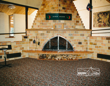
Article - Outer Circle Linear Park
OUTER CIRCLE LINEAR PARK, joint submission by cities of Kew, Camberwell, Malvern and Caulfield. A bound fifteen page submission, dated 08/07/1985, by four councils urging the creation of the Outer Circle Linear Park. Includes map and photographs. OUTER CIRCLE RAILWAY: A PLAN FOR A LINEAR PARK, report of the Outer Circle Study Group. Bound booklet of one hundred and thirty five typewritten and photocopied pages about the creation of this park. The Introduction was signed by Tom Roper, Minister for Planning and Environment, and by Joan Kirner, Minister for Conservation, Forests and Lands. Undated but the Introduction states that public submissions must be received by 31/05/1988. Includes maps, sketches of proposed facilities, a history of the former Outer Circle Railway Line, and a description of notable plants and trees. A double sided, one page leaflet, published by the Murrumbeena Outer Circle Parkland Retention Group, MOCPRG, with timeline of the park and map. Undated but the last date on the timeline is 1985. Includes small sheet headed WHAT CAN YOU DO? Cutting from the CAULFIELD CONTACT titled A NEW PARK IT’S OFFICIAL, dated 26/02/1988, on official announcement of the new park. Two copies of OUTER CIRCLE LINEAR PARK, a four paged pamphlet published by Outer Circle Linear Park Implementation Committee on the new park. Includes detailed map. Letter between Felicitie E. Campbell of the Caulfield Historical Society, dated 14/09/1988 supporting the naming of a section of the Linear Park as Boyd Park. Two pages typed and a hand written copy. Also a type written letter from Jim Badger, Manager, Cultural Services, City of Caulfield, supporting the naming as Boyd Park, dated 16/08/1988. An album of thirty five colour photographs by Peter Foeden and Associates, of the official opening of the Outer Circle Linear Park by Premier John Cain, 1988. Photographs are numbered and the album includes handwritten descriptions of each photograph. Two mounted photographs of the Caulfield section of Linear Park, undated. One black and white and one colour.outer circle linear park, outer circle railway, parks, saunders r. e., briggs a. g., quinn m., rudski b., outer circle study group, roper tom, kirner joan, dunstan david, railways, trees, murrumbeena, campbell felicitie e., badger jim, peter foeden and associates, campbell adack, lang robert, gallney cr., cain john, cain nancy, boyd john, boyd arthur, boyd merric, boyd penleigh, boyd robyn, boyd james, boyd guy, ballantyne mr. -
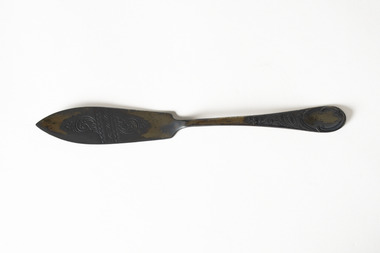 Chiltern Athenaeum Trust
Domestic object - Butter knife belonging to W.C.Busse
Wilfred Clarence Busse, born in Chiltern in 1898, His family moved to the region during the gold rush and continued to reside in the area, purchasing land adjacent the Murray River. Busse completed his secondary education at Wesley College in Melbourne then studied law at the University of Melbourne. Busse went on to become a barrister, often in the chambers of Sir Leo Finn Bernard Cussen (1859-1933) a judge of the Supreme Court of Victoria. He worked most of his life in Chiltern as a Barrister and Solicitor and gained the unofficial title of historian of Chiltern, leaving behind several manuscript histories and a scrap book. Busse was an avid fictional writer and in 1930 he published two novels. Time spent on a Victorian station in his early twenties, as well as careful documentary research, informed the writing of his historical novels of bush life. "The Blue Beyond; A Romance of the Early Days in South Eastern Australia” and "The Golden Plague: A Romance of the Early Fifties." "The Golden Plague” won the T. E. Role gold medal for the best historical novel which went on to become a best seller. Busse often drew inspiration for his novels from his younger years living Chiltern. His passion for the region lead him to write “The History of Chiltern” which was published in a serial form in the Chiltern Federal Standard from 1922-1923. Wilfred Clarence Busse was a member of Chiltern Athenaeum (where this object is now held) up until his death in 1960, he is buried in the Barnawartha Cemetery. Likely Silverplate due to the intensity of the tarnishing of the metal, with indecipherable hallmarks on the handle, the method of production and the maker mark are unclear. The delicate swirling fernlike motif on this particular butter knife appears to be stylised in either Art deco the decorative arts and craft style favoured in Europe between 1880-1930's and less representational than examples of Australiana flora captured in silversmithing from the 1850's onwards produced in Australia. It is likely that those producing silverware at the time would be drawing on the decorative arts movement while incorporating elements of the natural beauty in the flora of their newfound environment into the silverware they produced.Wilfred Clarence Busse was of social significance to Chiltern, he helped to document the cultural story of the area in his published works "The Golden Plague" and "The Beyond Blue" by recounting his own upbringing in a bush lifestyle. He was a respected Barrister and was the unofficial historian of the Chiltern Athenaeum for many years. This butter knife represents a window into the domestic life of this person who was well loved in the area, and it continues its relationship to Busse as well as Chiltern by being held within the very collection he helped to maintain in his life. Domestic objects tell us the story about how people lived, objects of daily use hold particular meaning in that they can tell us the story of an individual, we feel closer to their life and habits, it humanises and connects us across time. Wilfred Busse ate food, he buttered his bread and he did it with a wonderfully decorated silver butter knife.A tarnished metal butter knife with engraved and embossed spiral fern details on the knife and handlesilverware, wilfred clarence busse, busse, chiltern, chiltern athenaeum, federal standard, t. e. role, "the blue beyond, a romance of the early days in south eastern australia”, "the golden plague: a romance of the early fifties.", "the golden plague”, wesley college, university of melbourne, sir leo finn bernard cussen, supreme court of victoria, gold rush, murray river, “the history of chiltern”, silversmithing, decorative arts, floral, flora, australiana, australian flora, arts and craft movement, australian silver, cussen, cutlery, butter knife, knife, silverplate -
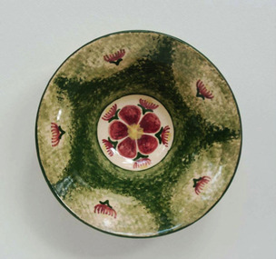 Duldig Studio museum + sculpture garden
Ceramic, Karl Duldig, Gumnut Bowl by Karl Duldig c.1948, c. 1948
Karl Duldig’s ceramic bowl is a particularly interesting example of Karl’s ability to creatively respond to a new environment with a fresh visual repertoire, in this case, the flowering Eucalyptus in a design reminiscent of traditional European folk art. The bowl is an excellent example of the utilitarian and decorative studio pottery produced by Karl and his wife Slawa Horowitz-Duldig between 1944 and 1960. Clay was an important medium for Karl. When he was forced to flee Austria for Switzerland, working with clay became a convenient medium; and he continued to expand his use of clay in Singapore. In Australia his work in clay extended from domestic hand-made pottery to public sculptures and architectural reliefs. In 1944 Duldig purchased a kiln, which was installed in the garage of the family’s St. Kilda flat, soon after a pottery wheel was acquired. It was the beginning of a cottage industry that supplemented the family income during the war years and beyond. Duldig initially sold his decorative ceramic wares through a local florist in St. Kilda, and subsequently through shops such as the Chez Nous French Art Shop (Howey Place) and Light and Shade (Royal Arcade), and the Primrose Pottery shop in Collins Street. The Primrose Pottery shop was an extremely important commercial outlet, and hub, for emerging artists, potters and designers from 1929 until 1974. Its proprietors Edith and Betty MacMillan worked closely with their suppliers, commissioning and taking items on consignment. In the post war period important Melbourne studio potters such as Allan Lowe, Arthur Boyd, John Perceval and Neil Douglas exhibited and sold domestic wares in the Primrose Pottery shop. The Duldigs studio pottery provides a counterpoint to the ceramics produced at Arthur Merric Boyd Pottery in Murrumbeena, which was established in 1944 by Arthur Boyd, John Perceval and Peter Herbst. The emphasis on painterly decoration was important and the AMB potters also produced simple household wares decorated with Australian flora and wildlife, for example Neil Douglas also made small bowls decorated with the fairy wrens, lyrebirds, gumnuts and eucalypts. Ann Carew 2016The Duldig Studio’s collection of ceramics has national aesthetic and historic significance. It contains a representative sample of works of art in ceramics created by Karl Duldig during his lifetime, including small sculptures, as well as functional and novelty items for the tourist market during the 1956 Melbourne Olympic Games. The artist’s working methods and the development of his practice are comprehensively demonstrated in the collection. This in-situ collection demonstrates the philosophy of the Vienna Secession and its inheritors that handcrafted, simple functional domestic wares might enrich both the lives of the maker and the user. This bowl is part of a collection of ceramics that has national historic significance in providing a rich illustration of an immigrant and artistic experience, and touching on the themes of settlement adaptation of artistic practice. The collection is also associated with places of cultural and historical significance in Melbourne such as the Primrose Pottery Shop, and the story of Australian studio ceramics in the post-war years. Ann Carew 2016Cream earthenware bowl with flowering gum motif and sponged green background.Duldig in script incised under. -
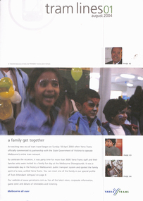 Melbourne Tram Museum
Magazine, Yarra Trams, "Tramlines", 2004 - 2009
Set of 15 issues of Yarra Trams Magazine "Tramlines" All folded A3 unless noted otherwise. 1 - Issue 1 - August 2004 - staff event, message from CEO Hubert Guyot, new control centre, route 96, Olympic torch relay, tram 431, new livery, meet Johnpaul tram attendant. .1A - Issue 2 - December 2004 - customer satisfaction, tram attendants, remembrance day, CEO message, new routes, Camberwell depot, staff profile and tramways band. .2 - issue 3 - May 2005 - Fleet operations control centre opens, (photo), Balaclava Junction upgrade, grand union, Melbourne Uni superstop, fund raising. .3 - issue 4 - August 2005 - Congratulations to Lenny Bates 50, departure of Hubert, route 75 extended to Vermont South, fare evasion, trackwork and Superstops in Flinders St and Bourke St, East Preston Depot and think tram project. .4 - Issue 5 - December 2005 - folded A3 sheet, plain paper, colour photos - with articles on congestion, advertising campaign success re fare evaders, new platform stops in Flinders St, Network improvements and getting ready for the 2006 Commonwealth games featuring a cartoon poster of a tram in a race (see Reg item 1235 for the actual poster). Has a message from Dennis Cliche - new CEO. .5 - Issue 6 - May 2006 - folded A2 sheet, gloss paper, items re Commonwealth games, Karachi W-11 tram, Remembrance day, network improvements, Grand Prix, good Friday appeal, and the forthcoming centenary celebrations. Centre page spread has a large number of photos of staff during the Commonwealth Games. .6 - Issue 7 - October 2006 - folded A2 sheet, gloss paper, colour photos of the Centenary Art Tram (5006), Myki, network improvements, memories of 1906, Luna Party Tram (1011) with centre page spread of a photo of 5006 outside Luna Park, and the various tram images featured on the tramcar. See also Reg Item 864 for details of the making of the art work. .7 - Issue 8 - December 2006 - folded A3 sheet, gloss paper, colour photos of the "Tram It 2006" event, light rail, TramTracker being launched, Essendon, Centenary celebrations and "for the love of trams". .8 - Issue 9 - May 2007 - six pages - traffic condition, green depots, Joyce Barry, plaque at Brunswick Depot, fund raising, platform stops, trackwork, TramTracker, Police tram. .9 - Issue 10 - September 2007 - MSO tram, students travels, Transport Challenge 2007, website, TramTracker by SMS. .10 - Issue 11 - Melbourne trams a heritage icon, fund raising, TramTracker, cable tram tracks in Abbotsford St, route 86 to the Waterfront City Docklands, hailing trams. 11 - Issue 12 - Mulhouse tram, Bumblebee, on the docks, fundraising, St Kilda Road upgrades, TramTracker. .12 - Issue 13 - Bumblebee C2 class trams, traffic congestion, wind power tram, Flinders St trackwork. .13 - Issue 14 - Silver Paralympians on tram, green wind powered trams. .14 - Issue 15 - TramTracker Jake, film festival, Public Transport Ombudsman - Simon Cohen, Operations Centre, .15 - Issue 16 - 6 pages - tram performance, TramTracker at tram stops and iPhones, Mike Talks, Myki. All have the Yarra Trams logo on the front cover.trams, tramways, yarra trams, tickets, commonwealth games, flinders st, grand prix, karachi w-11 tram, construction, luna park, essendon depot, centenary, tramtracker, olympic games, control centre, balaclava junction, trackwork, grand union, melbourne university, superstops, vermont south, route 75, flinders st, bourke st, brunswick depot, cable trams, docklands, mulhouse, c2 class, flinders st, environment, ombudsman, myki, tramways band -
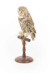 The Beechworth Burke Museum
Animal specimen - Ural Owl, Trustees of the Australian Museum, 1860-1880
Ural Owls are one of the largest nocturnal birds of prey and are distributed across Northern hemisphere land masses from Scandinavia in the west, across Russia and China to Japan in the east. They average between 500-640mm in length, have large ears, a very long tail, and wing spans up to 1340mm. Ural Owls display reverse sexual dimorphism. They have a range of calls and sounds that vary between regions and among subspecies. Ural Owls prefer mature primary forest habitats that are not too dense, but adapt to a range of environments, including damp heathland and high elevation mountain forests. The species is considered nocturnal but may be more correctly described as ‘cathemeral’, due to frequent daylight activity in the taiga zone. Ural Owls are non-migratory and highly territorial. They prefer to hunt from a perch into open areas of forest, seeking small mammal prey, such as voles, as well as birds, amphibians, and invertebrates. Ural Owls have a broad, rounded head and a well-developed round facial disc with a small V-shaped indentation. They tend to be plain greyish-brown to whitish overall, though some subspecies display darker colour variation. The underparts are pale cream to grey-brown and boldly overlaid with dark brown streaking. Ural Owls lack the richer colour tones of other Strix owls. Their flight style gives the appearance of a large bird. The eyes are dark brown and relatively small, and the bill is yellowish. Tarsi and toes are feathered grey and the talons are yellowish brown with darker tips. This specimen is part of a collection of almost 200 animal specimens that were originally acquired as skins from various institutions across Australia, including the Australian Museum in Sydney and the National Museum of Victoria (known as Museums Victoria since 1983), as well as individuals such as amateur anthropologist Reynell Eveleigh Johns between 1860-1880. These skins were then mounted by members of the Burke Museum Committee and put-on display in the formal space of the Museum’s original exhibition hall where they continue to be on display. This display of taxidermy mounts initially served to instruct visitors to the Burke Museum of the natural world around them, today it serves as an insight into the collecting habits of the 19th century.This specimen is part of a significant and rare taxidermy mount collection in the Burke Museum. This collection is scientifically and culturally important for reminding us of how science continues to shape our understanding of the modern world. They demonstrate a capacity to hold evidence of how Australia’s fauna history existed in the past and are potentially important for future environmental research. This collection continues to be on display in the Museum and has become a key part to interpreting the collecting habits of the 19th century. This Ural Owl is an average sized specimen with a broad, rounded head and characteristic V-shaped facial marking between the eyes. Overall plumage is plain and consistent in colour and pattern, with white, brown and grey streaks. The eyes are large and the bill is small and yellow. This specimen stands on a wooden perch with identification tags attached to its leg.Swing tag: Strix noctua / Athene noctua, [illegible] / near leiden / 26 Mai 1860. / Holland / Other tag: N38 / Strix noctua / Holland. / Metal tag: 4062 /taxidermy, taxidermy mount, burke museum, australian museum, owls, birds of prey, heart-shaped faced owl, nocturnal birds, predator birds, carnivore, territorial owl, animalia, large owl, long-tailed owls, ural mountains, taiga zone owls, cathemeral, monogamous, iucn red list, strix, wood owl, attacking owl, long-tailed owl, large-eared owl, owls with facial disc -
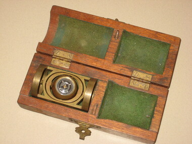 Federation University Historical Collection
Instrument - Scientific Instrument, Pajari Instruments, Boxed Tropari
This item was most probably used at the Ballarat School of Mines. Pajari Instruments Ltd. grew from a partnership established in 1945 when the first EX-AX surveying instrument that provided accurate azimuth and inclination was made available to the diamond drilling industry. The partnership between Charles Trotter and George Pajari Sr. was known as Trotter-Pajari Instruments and the EX-AX Instrument was dubbed the "TROPARI" by the diamond drilling industry. Charles Trotter, a mechanical engineer, was also a marketing genius who developed substantial demand in Australia, Africa and South America in the 1940's and early 1950's. In fact the sales to each of these continents exceeded those to North America during those early years. Pajari is located in Orillia, Ontario, Canada and offer services and products that assist customers with their individual requirements. After the death of Charles Trotter in 1956, George Pajari Sr. with the assistance of his wife Hilda continued the business under the title of Pajari Instruments. George Sr. set most of the tenets that comprise our present Mission Statement. If it wasn't user friendly or if it had to have experts to operate it, that instrument design was doomed. If the customer wasn't getting good value in his opinion, manufacturing and repair procedures were examined to see where efficiency could be improved to cut costs without sacrificing Quality. George Pajari Jr and his wife Darlene assumed the reins of Pajari Instruments Ltd. in 1981 when George Sr. decided on semi-retirement. George Jr. brought the "client geologist's" perspective to the company. The company moved from Toronto to a 30 hectare (80 acre) site near Orillia shortly afterward. This site provided the high magnetic latitude earth field environment without magnetic pollution that is necessary for accurate compass setting. The park like setting of this location is a positive psychological benefit for our staff. George Sr. passed away in 2002 being preceded by Hilda only by 3 months, George Jr. continues at the helm of the company. With dedication from long term employees/contractors and third generation family members, Pajari Instruments Ltd. continues operations/new product development in Orillia. (http://www.pajari.com/about.html) Brass levelling compass in green velvet lined hinged timber box. Known as a Tropari - a single-shot, micro-mechanical borehole surveying instrument operated by a timing device. Borehole direction is measured from the earth's magnetic field. The Tropari provides both direction and inclination which can be used to define the attitude of the borehole at the survey depth. Regular surveys at intervals as the borehole progresses will allow a plot of the borehole to be drawn from the data. The Tropari is easy to use and maximizes profits by minimizing capital and operational costs. The Basic Survey Train Consists of: PDSI / Tropari Container, 6m (20 ft) Nonmagnetic Rods, Impact Foot, and Connector at Top. (http://www.pajari.com/tropari.html) A sticker on the lid of the hinged box states: "A.E. Parsons 107 Leicester St., Carlton 3053 Telephone 347 5844"scientific instrument, compass -
![Diary, [Digital file].1840-1841. Charles Griffith](/media/collectors/5e461d8021ea67224c82f2a1/items/67a209aff435c92f9910fa93/item-media/67a20ae0f435c92f9910fc3e/item-fit-380x285.jpg) Bacchus Marsh & District Historical Society
Bacchus Marsh & District Historical SocietyDiary, [Digital file].1840-1841. Charles Griffith
Charles Griffith was born in Kildare, Ireland in 1808. He studied at Trinity College, Dublin acquiring a B.A. in 1829 and an M.A. in 1832 before being admitted to practice as barister. In 1840 he emigrated to Australia arriving in the Port Phillip District in November 1840. Soon after arriving he and his friend James Moore formed a business partnership and acquired land in the Parwan Valley near Bacchus Marsh. This land had been in the possession of a Mr. McKenzie who agreed to sell his land and sheep to Griffith and Moore. The property they acquired came to be known as Glenmore. The partnership with James Moore lasted until 1848. In 1846, whilst in Ireland, Griffith married Miss Jane Catherine Magee, then returned to Glenmore and later took his nephew, Molesworth Richard Greene, into partnership, which arrangement proved to be long and prosperous. In 1857, they bought runs at Mount Hope and Mount Pyramid, which they kept until the days of free selection. Griffith led an active and successful public life. He was a member of the new Victorian Legislative Council in 1851, and was later an elected representative of the Legislative Assembly 1853-1859. He occupied many important public positions, including that of magistrate for Bacchus Marsh. Griffith was a devout Anglican and hosted Bishop Charles Perry at his station near Bacchus Marsh in 1849. He died in 1863 at his home in South Yarra. The diary is a detailed account of Griffith's voyage from Ireland to Australia and of his early months in Melbourne. After this it covers his early months establishing himself on his property, Glenmore, near Bacchus Marsh. The timeline of the diary stretches across 1840 and 1841. Griffith was an educated gentleman who made detailed observations about the environment he found himself in. The diary is particularly notable for Griffith's commentary about his interactions with people from first nations, and reveals some of his thinking about Colonial policies directed at first nations people. The diary also includes some sketches of individual first nations people along with some sketches of flora and fauna. The final part of the diary includes a glossary of Aboriginal words Griffith was familiar with. Digital file. PDF format. Digitised by State Library Victoria from photocopied pages of a hand-written transcription of the original diaries written by Charles J. (James) Griffith in 1840 and 1841.charles james griffith 1808-1863, diaries bacchus marsh, glenmore station, wadawurrung people, aboriginal australians bacchus marsh region history -
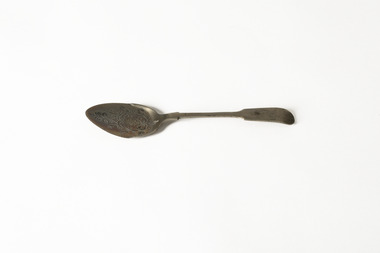 Chiltern Athenaeum Trust
Domestic object - Spoon belonging to W.C.Busse
Wilfred Clarence Busse, born in Chiltern in 1898, His family moved to the region during the gold rush and continued to reside in the area, purchasing land adjacent the Murray River. Busse completed his secondary education at Wesley College in Melbourne then studied law at the University of Melbourne. Busse went on to become a barrister, often in the chambers of Sir Leo Finn Bernard Cussen (1859-1933) a judge of the Supreme Court of Victoria. He worked most of his life in Chiltern as a Barrister and Solicitor and gained the unofficial title of historian of Chiltern, leaving behind several manuscript histories and a scrap book. Busse was an avid fictional writer and in 1930 he published two novels. Time spent on a Victorian station in his early twenties, as well as careful documentary research, informed the writing of his historical novels of bush life. "The Blue Beyond; A Romance of the Early Days in South Eastern Australia” and "The Golden Plague: A Romance of the Early Fifties." "The Golden Plague” won the T. E. Role gold medal for the best historical novel which went on to become a best seller. Busse often drew inspiration for his novels from his younger years living Chiltern. His passion for the region lead him to write “The History of Chiltern” which was published in a serial form in the Chiltern Federal Standard from 1922-1923. Wilfred Clarence Busse was a member of Chiltern Athenaeum (where this object is now held) up until his death in 1960, he is buried in the Barnawartha Cemetery. The floral motif on this particular spoon appears to be stylised in the decorative arts and craft style favoured in Europe between 1880-1920 and less representational than examples of Australiana flora captured in silversmithing from the 1850's onwards produced in Australia. It is likely that those producing silverware at the time would be drawing on the decorative arts movement while incorporating elements of the natural beauty in the flora of their newfound environment into the silverware they produced. This spoon seems more likely to have been produced in Europe and imported to the colony. The hallmarks on the handle DON and BP indicate it may have been produced from English electroplating silver which is a more cost effective product than solid silver, most likely produced by Cooper Brothers, Don Plate Works, established in Sheffield in 1866 who distributed silverware in Europe, America and the colonies well into the 1950's.Wilfred Clarence Busse was of social significance to Chiltern, he helped to document the cultural story of the area in his published works "The Golden Plague" and "The Beyond Blue" by recounting his own upbringing in a bush lifestyle. He was a respected Barrister and was the unofficial historian of the Chiltern Athenaeum for many years. This spoon represents a window into the domestic life of this person who was well loved in the area, and it continues its relationship to Busse as well as Chiltern by being held within the very collection he helped to maintain in his life. Domestic objects tell us the story about how people lived, objects of daily use hold particular meaning in that they can tell us the story of an individual, we feel closer to their life and habits, it humanises and connects us across time. Wilfred Busse ate food and he did it from a beautiful silver floral detailed spoon.A silver tablespoon with floral embossed head and hallmarks embossed on reverse handleDON/ BP/silverware, wilfred clarence busse, busse, chiltern, chiltern athenaeum, federal standard, t. e. role, "the blue beyond, a romance of the early days in south eastern australia”, "the golden plague: a romance of the early fifties.", "the golden plague”, wesley college, university of melbourne, sir leo finn bernard cussen, supreme court of victoria, gold rush, murray river, “the history of chiltern”, silversmithing, spoon, decorative arts, floral, flora, australiana, australian flora, arts and craft movement, australian silver, cussen -
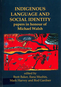 Victorian Aboriginal Corporation for Languages
Book, Brett Baker, Indigenous language and social identity : papers in honour of Michael Walsh, 2010
For almost 40 years, Michael Walsh has been working alongside Indigenous people: documenting language, music and other traditional knowledge, acting on behalf of claimants to land in the Northern Territory, and making crucial contributions to the revitalisation of Aboriginal languages in NSW. This volume, with contributions from his colleagues and students, celebrates his abiding interest in and commitment to Indigenous society with papers in two broad themes. ?Language, identity and country? addresses the often complex relations between Aboriginal social groups and countries, and linguistic identity. In ?Language, identity and social action? authors discuss the role that language plays in maintaining social identities in the realms of conversation, story-telling, music, language games, and in education. ?Language and Social Identity in Australian Indigenous Communities? will be of interest to students of linguistics, Indigenous studies, anthropology, and sociology. Contents: 1. Introduction /? Rod Gardner ... [et al.] 2. Michael Walsh : a personal reflection /? Ros Fraser 3. Place and property at Yintjingga/?Port Stewart under Aboriginal Law and Queensland Law /? Bruce Rigsby and Diane Hafner 4. Linguistic identities in the eastern Western Desert : the Tindale evidence /? Peter Sutton Juwaliny : dialectal variation and ethnolinguistic identity in the Great Sandy Desert /? Sally Dixon 6. Who were the 'Yukul'? and who are they now? /? Brett Baker 7. Colonisation and Aboriginal concepts of land tenure in the Darwin region /? Mark Harvey 8. Aboriginal languages and social groups in the Canberra region : interpreting the historical documentation /? Harold Koch 9. The Kuringgai puzzle : languages and dialects on the NSW Mid Coast /? Jim Wafer and Amanda Lissarrague 10. Dawes' Law generalised : cluster simplification in the coastal dialect of the Sydney language /? David Nash 11. Space, time and environment in Kala Lagaw Ya /? Lesley Stirling 12. Turn management in Garrwa mixed-language conversations /? Ilana Mushin and Rod Gardner 13. Laughter is the best medicine : roles for prosody in a Murriny Patha conversational narrative /? Joe Blythe 14. Collaborative narration and cross-speaker repetition in Umpila and Kuuku Ya'u /? Clair Hill 15. Co-narration of a Koko-Bera story : giants in Cape York Peninsula /? Paul BlackMaps, b&w photographs, charts, word listslanguage and identity, language maintenance, language and culture, language and country -
 The Beechworth Burke Museum
Photograph - Photograph - Reproduction, c.1870s
This photograph shows a piece of gold mining equipment identified as a mine winch, possibly an air winch cylinder of 1870s RG Ford's Patent design. Throughout the history of mining for gold and other precious materials, the windlass or winch (pictured) was used to bring up buckets full of soil from the bottom of a mine. This soil was then searched for gold/metals before being relocated to a different area. Due to the size and complexity of this particular piece of equipment, this winch may have been used to raise and lower mine carts to the entrance of the mine (often used in coal mining) and could have been used in raising cages up and down (acting as elevators) containing miners if the mine was particularly deep. The actual use of this particular item in the Beechworth locality is undocumented but these are some possibilities based on the use of these pieces of equipment in other mining locations. Mining can have a largely detrimental impact to the environment and therefore, the study of machinery like the one depicted in this photograph can help researches to reconstruct the methods and technologies used in the late 1800s and early 1900s. This particular item appears to have been removed from it's original site where it would have been used to assist with mining. It is possible that this photograph has been taken for recording purposes or as part of a machinery exhibition. Prior documentation records that this piece of equipment had connections to the Rocky Mountains Mining Company. Today, the Rocky Mountains Gold Mining company is famous in Beechworth for having been instrumental in the creation of the Rocky Mountain tunnel. Construction for this tunnel began in 1859 when a group of 12 men blasted a 400ft long tailrace though the rock beneath the town of Beechworth. Today, the 800ft tunnel, completed in 1871, is a popular tourist attraction but during the decades of gold mining, the purpose of this tunnel was to divert water away from the main sluicing operations so miners could better access gold and precious materials. The tunnel was used for this purpose for many years, later becoming useful for the Zwar Brother's tannery and currently as an outfall drain for Lake Sambell. This area continued to be mined until the early 1900s. The period when this item was in use is unclear but it is estimated to have been in the 1870s based on the design and appearance of the image. The gold works at the Rocky Mountain Tunnel closed in the early 1920s but the impact of mining remains in Beechworth today and therefore the study of photographs like this one which contain mining equipment can further understanding of mining in this region.This photograph has historic and research potential for study on the gold mining of the Beechworth region and types of equipment used to locate gold after the initial gold rush of 1853-1854 which resulted in the discovery of the surface gold and required miners to dig deeper to access precious metals. The clarity of the photo, and its good preserved condition, means it can continue to be used for research. This photo is part of a collection of six photos all within the Burke Museum Collection which depict mining equipment.Square black and white photograph on card.7793.1beechworth, mining, goldmining, goldmining equipment, beechworth burke museum -
 Flagstaff Hill Maritime Museum and Village
Container - Earthenware jar, Bailey & Co, circa 1878
The handmade earthenware jar was one of a group of artefacts in the McCulloch Collection that were recovered from the shipwreck Loch Ard. The jar could have been from the ship's cargo or personal effects. There are other jars in our collection that were recovered from the Loch Ard. The object is now one of the shipwreck artefacts in Flagstaff Hill’s Mc Culloch Collection, which includes items recovered from the wrecks of the Victoria Tower (wrecked in 1869) and Loch Ard (wrecked in 1878). They were salvaged by a diver in the early 1970s from the southwest coast of Victoria. Advanced marine technology had enabled divers to explore the depths of the ocean and gather its treasures before protective legislation was introduced by the Government. The artefacts were donated to Queensland’s Department of Environment and Heritage Protection (EHP) by a passionate shipwreck lover and their locations were verified by Bruce McCulloch. In 2017 the Department repatriated them to Flagstaff Hill where they joined our vast collection of artefacts from Victoria’s Shipwreck Coast. The Loch Ard: - The three-masted, square-rigged iron ship Loch Ard belonged to the famous Loch Line which sailed many ships from England to Australia. The ship was built in Glasgow in 1873. The Loch Ard made three trips to Australia and one trip to Calcutta before its final voyage. The Loch Ard left England on March 2, 1878, under the command of Captain Gibbs, bound for Melbourne with a crew of 37, plus 17 passengers and a load of cargo. The general cargo included straw hats, umbrellas, perfumes, clay pipes, pianos, clocks, confectionery, linen and candles, as well as a heavier load of railway irons, cement, lead and copper. There were items included that were intended for display in the 1880 Melbourne International Exhibition, including the famous Loch Ard Peacock. On June 1, 1878, Captain Gibbs was expecting to see land but visibility was reduced by fog. As it lifted, the sheer cliffs of Victoria's west coast came much closer than expected. The captain was unable to steer away and the ship struck a reef at the base of Mutton Bird Island, near Port Campbell. The top deck was loosened from the hull, the masts and rigging came down and knocked passengers and crew overboard, and even the lifeboat crashed into the side of the ship and capsized. Of the 54 people on board, only two survived: the apprentice, Tom Pearce and the young woman passenger, Eva Carmichael. The well-packed Minton porcelain peacock also survived, safe inside its crate. Much of the cargo was washed up, smashed and broken, and some was salvaged. Other cargo is still with the wreck at the base of Mutton Bird Island, now protected by Government law. The artefact is an example of cargo or personal items on board a ship in 1878. It provides a reference point for classifying and dating similar items. This artefact is significant for its association with the sailing ship Loch Ard, one of the best-known, and one of the worst, shipwrecks in Victoria’s history. Flagstaff Hill’s collection of artefacts from Loch Ard is significant for being one of the largest collections of artefacts from this shipwreck in Victoria. It is significant for its association with the shipwreck, which is on the Victorian Heritage Register (VHR S417). The collection is significant because of the relationship between the objects, as together they have a high potential to interpret the story of the Loch Ard. The Loch Ard collection is archaeologically significant as the remains of a large international passenger and cargo ship. It is historically significant for representing aspects of Victoria’s shipping history. Container, round brown earthenware jar with a wide mouth, thick lip, a wide neck that tapers slightly inwards towards the shoulder, and a body that tapers slightly inward towards the base. The glazed surface is rough. The variegated colours of the clay also has small dark speckles. There are several chips and dents on the jar. The inscription is stamped into the lower edge. Made by Bailey & Co., England. Recovered from the wreck of the Loch Ard.Inscription “Bailey [&] Co / ENGLAND” flagstaff hill, warrnambool, flagstaff hill maritime museum, maritime museum, shipwreck coast, flagstaff hill maritime village, great ocean road, white star line, victorian heritage register, sailing ship loch ard, loch line, loch ard, captain gibbs, eva carmichael, tom pearce, glenample station, mutton bird island, loch ard gorge, migrant ship 1878, cargo ship 1878, stoneware jar, domestic container, kitchenware, kitchen storage, bailey & co england, shipwreck artefact, wreck dive, mcculloch collection, bruce mcculloch, 1878, sailing ship, earthenware, stoneware, domestic jar -
 Glen Eira Historical Society
Letter - ELSTERNWICK POST OFFICE
This file contains seven items about the significance of this building and how this was established : 1/ Photocopies of a handwritten application (in duplicate) by Walter Kay of Elsternwick dated 13/10/1985 and Rodney H Bush’s dated 16/10/1985 to the Historic Buildings Council to register the former Elsternwick Post Office building, and an original typewritten letter dated 17/10/1985 from the Historic Buildings Council to Caulfield and Historic Society advising them of an application and inviting them to submit relevant information about the building with a copy of application attached. 2/ Six pieces of correspondence between various interested parties (Caulfield Council , Caulfield Historical Society, National Trust, of Australia and Ministry for Planning and Environment on behalf of Historic Buildings Council, Victoria) about the significance of the former Elsternwick Post Office building and the progress of efforts to include it on the Register of Historic buildings. Dated between November 1985 and May 1986. 3/ Two pieces of correspondence between the Caulfield Progress Association and the Caulfield Historical Society dated April and May 1986, regarding the efforts of the Historical Society to save the former Elsternwick Post Office building. 4/ Two pieces of ephemera by the Caulfield Progress Association, one original undated and one photocopy undated in 1986. Both appealing to the public for support to help the former Elsternwick Post Office building and to protest a proposal to demolish it, by Caulfield Council. 5/Original newspaper article dated 07/06/1989 from the Malvern-Caulfield Progress newspaper written by Robert Carmody. The article talks about the approval by the Historic Buildings Council of Caulfield Council’s restoration program of the former Elsternwick Post Office building worth approximately $850,000. The refurbishment would consist of a shop and office space which would then be rented out. Mayor Emil Braun outlines the progress to implement the plans. 6/ Caulfield Conservation Study by Andrew Ward dated September 1994 of former Elsternwick Post Office Building. The building plans for the Elizabethan Style building were approved in 1891. The original timber verandahs were replaced by the present brickworks in circa 1918 rear extensions in 1941-42. Similar Post Offices were built at Kew, Queenscliff and Portarlington. 7/ Computer printout dated 19/03/2010 of Statement of Significance held by the Victorian Heritage database of the former Elsternwick Post Office Building. It was built in 1891 in the ‘Queen Anne’ style. The substantial two story red brick building was set on a bluestone plinth with an ornate façade incorporating cement dressings. There is a brief summary of the settlement and development of the Elsternwick area with mention of how important the building is to the Elsternwick Community. Original date and author is unknown.elsternwick post office, glenhuntly road, elsternwick, riddell parade, office buildings, postal services, caulfield city council, kay walter, regent street, caulfield, bush rodney h, gisborne street, city of caulfield, braun emil councillor, mayors, aylen doug, aylen douglas r, historic buildings council, caulfield historical society, ministry for planning and environment, head stephen, historic buildings act 1981, anderson p, national trust of australia (victoria), public works department, architectural styles, calder g.k. councillor, wills cathie, lyall kerry, marsden john hudson, town clerk, hill douglas, caulfield progress association, caulfield south, glen eira road, hawthorn road, mac neil j.r., neville street, glenhuntly, marten veronika, ballantyne richard, royal historical society of victoria, dunstan don, alfada street south, hardy joan, baird rob, snowball betty, ward andrew, hoddle robert, foot henry, ebden charles hodson, elster, oldham mary kate, english ‘queen anne’ revival style, rifle club, coulson herbert h., fick p.g., railway, city manager, austin g.b. h., architects, builders, architectural features, australia post, register of historical buildings, grey karen, planning appeal board, heritage overlay no h029, victorian government gazette no. 60 dated 16/07/1986, historic building no640, certificate of title volume 5817, kennan james harley, nelson ivor, blake alison, neale anne, telegraph offices, wardell, ward andrew