Showing 23060 items matching "creek"
-
 Stawell Historical Society Inc
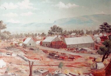
Photograph, Original Painting of The Reef Hotel Pleasant Creek with Bullock team in front from an original by Will Rees
Original Painting of The Reefs Hotel Pleasant Creek with Bullock team in front from an original by Will Reesstawell -
 Stawell Historical Society Inc
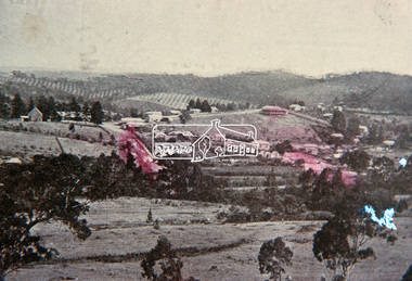
Photograph, Pleasant Creek -- Stawell Hospital & Benevolent Asylum
Pleasant Creek Hospital and Benevolent Asylum. Stawell Hospital. Gardens in foreground and several nursing staffstawell hospital medical -
 Stawell Historical Society Inc
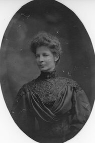
Photograph, Pleasant Creek -- Stawell Hospital -- Mrs W H Syme nee Unknown -- donor of Syme Ward -- Studio Portrait
Pleasant Creek. Stawell Hospital Portrait of Mrs. W. H. Syme donor of Syme Ward.stawell hospital medical -
 Stawell Historical Society Inc
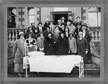
Photograph, Pleasant Creek Hospital & the Presentation of a Hospital Bed made by the mothers club from Primary School Number 502 1926
Pleasant Creek Hospital 1926 Presentation made by mothers club Primary School 502 of bed.stawell education medical -
 Greensborough Historical Society
Map, Melbourne and Metropolitan Board of Works. Survey Division, MMBW, Yarra 2500 / 14.23. Diamond Creek, Sutherland Homes, 1979_05
Melbourne and Metropolitan Board of Works. Yarra 2500 [base map] 14.23. Diamond Creek, Sutherland Homes. Parish of Morang 3183 and Nillumbik 3310. Municipality of Diamond Valley 257. Prominent streets Aqueduct Road, Diamond Creek Road, Yan Yean Road and McLaughlans Lane. Features include the abandoned Maroondah aqueduct and Sutherland Cottages.MMBW Map in 1:2500 [scale] series. Cream parchment with green tape reinforcing on edges and punched holes on left edge.mmbw, melbourne and metropolitan board of works, shire of diamond valley, plenty - maps, sutherland homes, maroondah aqueduct -
 Eltham District Historical Society Inc
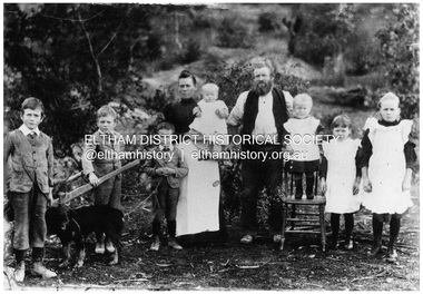
Negative - Photograph, Sabina and Will Mills and family, Upper Diamond Creek (Wattle Glen), c.1899
Sabina and William Henry Mills lived at "Golden Valley", Upper Diamond Creek (Wattle Glen) and had nine children in total. Here they are pictured with seven young children. Sabina died in 1916 aged 57 and William died in 1921 age 64. They are buried together at Diamond Creek (Nillumbik) cemetery. Reproduced on p46 of 'Pioneers & Painters'This photo forms part of a collection of photographs gathered by the Shire of Eltham for their centenary project book, "Pioneers and Painters: 100 years of the Shire of Eltham" by Alan Marshall (1971). The collection of over 500 images is held in partnership between Eltham District Historical Society and Yarra Plenty Regional Library (Eltham Library) and is now formally known as 'The Shire of Eltham Pioneers Photograph Collection.' It is significant in being the first community sourced collection representing the places and people of the Shire's first one hundred years.Digital image 4 x 5 inch B&W Neg 20 x 25 cm printsepp, shire of eltham pioneers photograph collection, wattle glen, sabina mills, will mills, mills family, pioneers and painters, upper diamond creek -
Stawell Historical Society Inc
Archive, Archives from Pleasant Creek Training Centre
-1 Large Ledger 1943 Tools & Consumables for Manual Training Class. -2 Pleasant Creek Special School, School Policy and Curriculum 1947 -3 2 X WEL magazines 1983 -4 Test Material for the Measurement of Intelligence -5 Invitation for registration of expression of interest for Former Pleasant Creek Centre at Western Highway Stawell.Large Green Ledger with Brown Spine. Yellow covered Book with black binding combs. Two A3 Sized Negative Booklets. Two sets of Intelligence Test Material. Expression of Interest for site.education -
Hume City Civic Collection
Photograph, Jacksons Creek Viaduct
The four arch railway bridge, known as the Jacksons Creek Viaduct Bridge, spans the Jacksons Creek north of the Sunbury Railway Station. The weir at the base of the bridge was used to dam water as well as ensuring a water supply for the steam trains. The pump house at the base of the bridge was where the water was pumped and then taken to the railway station for the steam engines.This bridge is one of notable four railway bridges along the railway line that are in Sunbury. An enlarged black and white photograph with a white border of a high bridge over a watercourse.bridges, jacksons creek viaduct, jacksons creek viaduct bridge, railways -
 Ringwood and District Historical Society
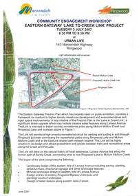
Document - Community Engagement Workshop, Eastern Gateway "Lake To Creek Link" Project - Ringwood, Victoria, 2007
2-page Maroondah City Council notice for workshop on Tuesday 3 July 2007 at Urban Life, 143 Maroondah Highway, Ringwood - light refreshments served.A key initiative of the Precinct Plan is the significant street upgrade which may include creative water features along Larissa Avenue to better connect recreational paths along Mullum Mullum Creek and Ringwood Lake. -
 Lakes Entrance Historical Society
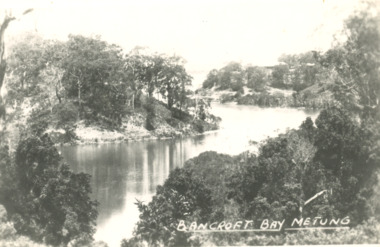
Postcard, Chinamans Creek, Bancroft Bay Metung Victoria, 1930 c
Black and white postcard of timbered shore of Chinamans Creek looking south towards Bancroft Bay Metung Victoria. Also three small black and white postcards taken from same viewing point Metung. Plus three other colour photos of a more recent view waterways -
 Stawell Historical Society Inc
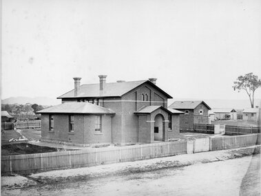
Photograph, Court House and Cells Pleasant Creek Stawell 1866
Court House and Cells Pleasant Creek Stawell. Part of a collection of Photographs by Mr. O.G. Armstrong as commissioned by the Shire of Stawell for the Inter-colonial and Paris Exhibition in Melbourne in 1866. The first courthouse was built at Pleasant Creek Stawell by William Scobie for the sum of £1975 in September 1858. A further sum of £1832 was spent on the building by J. Francis in January 1860. Pleasant Creek Court House was used as a court of Petty sessions, County Court, Court of Mines, and a Court of General Sessions before the newer Stawell Court House in Patrick Street was built. Later it was used as a police barracks then private home. stawell government -
 Eltham District Historical Society Inc
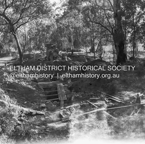
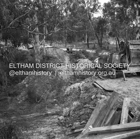
Negative - Photograph, J.A. McDonald, Henley Road at Watsons Creek, Apr. 1961
Henley Road at Watsons Creek looking westerly showing west abutment excavation Mid April 1961Record of various Shire of Eltham infrastructure works undertaken during the period of 1952-1962 involving bridge and road reconstruction projects, sometimes with Eltham Shire Council Project Reference numbers quoted. It was during this period that a number of significant improvements were made to roads and new bridges constructed within the shire that remain in place as of present day (2022). In many situations, the photos provide a tangible visible record of infrastructure that existed throughout the early days of the Shire. The album was put together by or under the direction of the Shire Engineer, J.A. McDonald.infrastructure, shire of eltham, bend of islands, cr. charis pelling, henley road, henley road bridge, kangaroo ground, oxley bridge, watsons creek, w.e. wolf, bridge construction, road construction, 1961-04 -
 Eltham District Historical Society Inc
Slide, View overlooking Diamond Creek, 1907
View overlooking Diamond Creek to the northeast, most likely from near St John's Church, 190735 mm colour positive transparency of a newsprint image taken c.1970 Mount - Kodak Kodachrome Card13diamond creek township -
 Eltham District Historical Society Inc
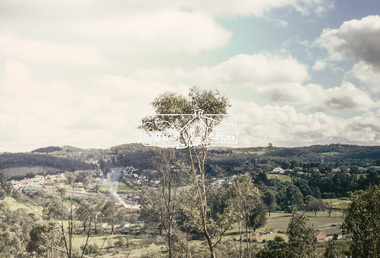
Slide, View overlooking Diamond Creek, 1970
View overlooking Diamond Creek to the northeast, most likely from near St John's Church, 197035 mm colour positive transparency of a newsprint image taken c.1970 Mount - Kodak Kodachrome Card27diamond creek township -
 Eltham District Historical Society Inc
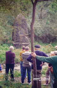
Photograph, Gold Memorial Cairn, Andersons Creek; Warrandyte Mystery Tour, 29 May 1994, 29/05/1994
The Cairn commemorates the disclosure of Gold Discovery at Warrandyte on June 30th 1851 beside Anderson's Creek RoadColour photographactivities, gold memorial cairn, warrandyte, andersons creek -
 Stawell Historical Society Inc
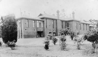
Photograph, Pleasant Creek -- Stawell Hospital Infectious Diseases Ward -- Syme Ward Opened 1904
Pleasant Creek. Stawell Hospital Infectious Diseases Ward Syme Ward Opened 1904 Nurses in Frontstawell hospital medical -
 Stawell Historical Society Inc
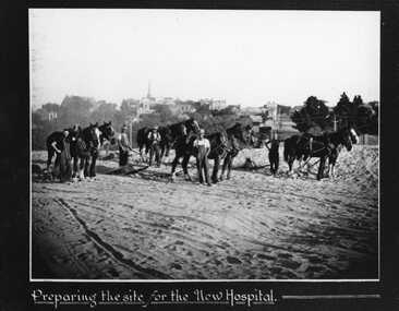
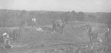
Photograph, Pleasant Creek -- Stawell Hospital site being prepared with workmen & horse drawn levellers
Pleasant Creek. Stawell Hospital Workmen on New Hospital Site preparing the site with horse drawn levellers.stawell hospital -
Stawell Historical Society Inc
Photograph, Pleasant Creek -- Stawell Hospital Infectious Diseases Ward -- Syme Ward Opened 1904
Pleasant Creek. Stawell Hospital Infectious Diseases Ward Syme Ward Opened 1904 Nurses in Frontstawell hospital medical -
 Stawell Historical Society Inc
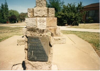
Photograph, Cemetery Memorial erected at One Tree Hill Cemetery at Pleasant Creek 1935 Colour Photgraph
Group of people at original cemetery. One Tree Hill Cemetery Pleasant Creek. Memorial erected 1935stawell -
 Stawell Historical Society Inc
Photograph, Original Cemetery Memorial erected at One Tree Hill Cemetery at Pleasant Creek 1935
Group of people at original cemetery. One Tree Hill Cemetery Pleasant Creek. Memorial erected 1935stawell -
 Stawell Historical Society Inc
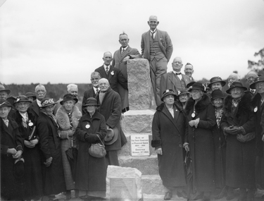
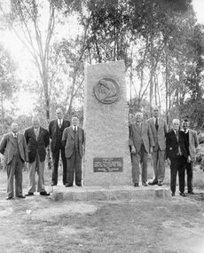
Photograph, Stawell Progress Association Members beside the Gold Memorial monument to the discovery of gold at Pleasant Creek 1953
Stawell Progress Association Members 1953 beside Gold Memorial monument to the discovery of gold at Pleasant Creek.stawell -
 Stawell Historical Society Inc
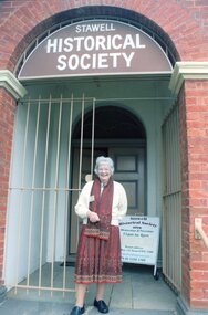
Photograph, Dorothy Brumby – President Stawell Historical Society on the steps of old Pleasant Creek Court House 2015
Dorothy Brumby – President Stawell Historical Society 2015 on steps of old Pleasant Creek Court House stawell portrait -
 Eltham District Historical Society Inc
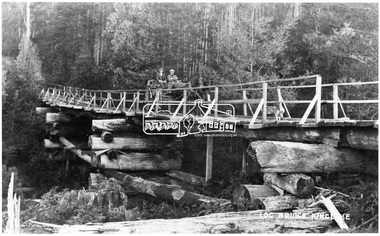
Negative - Photograph, Log bridge over Pheasant Creek, Kinglake, c.1920
Horse and cart with driver Mr. F. Thomson and passenger cross a wooden bridge with log tree trunk base construction supported by timber rails over Johnstone's Creek amidst the Kinglake forest. The bridge was built for the timber tramline. There was also a logging district in the Pheasant Creek area just outside the Shire of Eltham. Note dog also sitting on bridge.This photo forms part of a collection of photographs gathered by the Shire of Eltham for their centenary project book,"Pioneers and Painters: 100 years of the Shire of Eltham" by Alan Marshall (1971). The collection of over 500 images is held in partnership between Eltham District Historical Society and Yarra Plenty Regional Library (Eltham Library) and is now formally known as 'The Shire of Eltham Pioneers Photograph Collection.' It is significant in being the first community sourced collection representing the places and people of the Shire's first one hundred years.Digital image 4 x 5 inch B&W Neg 120 format B&W negative (spare) 2 x printsbridge, f. thomson, kinglake, log bridge, mr. munro, pheasant creek, pioneers and painters, shire of eltham pioneers photograph collection, timber tramway -
 Falls Creek Historical Society
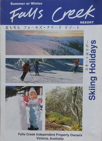
Booklet - Falls Creek Resort Skiing Holidays 1992
This booklet is part of an annual promotional campaign for Falls Creek. It contains headings and sentences of information in Japanese, which reflects the increase in international tourism and marketing. It was designed by the Falls Creek Independent Property Owners, Victoria. The information panel on the back cover indicates it was part of Australia's Southern Region Tourism Promotion C/O Australian Tourism Commission in Tokyo, Japan.This item is important as it documents seasonal activities at Falls Creek and a changing approach to international marketing. An A4 sized marketing booklet, including images and advertising information printed on glossy paper. This publication includes headings and short lines of texts in Japanese script.falls creek marketing, falls creek information, falls creek international tourism, falls creek holiday brochures -
 Hume City Civic Collection
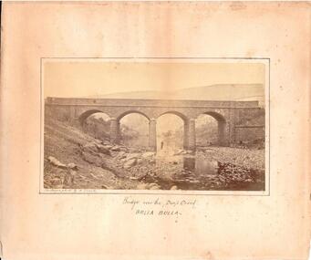
Photograph, c. 1870s - 1880s
The phtograph was taken by Alfred Sinel who was the local photgrapher in Sunbury. The four arched bridge spans the river at Deep Creek, Bulla. The bridge replaced the forde crossing which is in the foreground of the photograph. Alfred Sinel is listed in the 1874 rate book as a photographer - artist.A mounted sepia photograph of the four-arched bluestone bridge over Deep Creek at Bulla. A man is standing under the 3rd arch from the LHS. The cream mount has a ruled ink frame around the photo. The caption has been hand-written under the photograph.BRIDGE OVER THE DEEP CREEK / BULLA BULLAdeep creek, bridges, bulla, sunbury, sinel, alfred, photographers, george evans collection -
 Eltham District Historical Society Inc
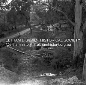
Negative - Photograph, J.A. McDonald, Henley Road at Watsons Creek, Apr. 1961
Henley Road at Watsons Creek looking easterly along centreline from west abutment Early April 1961Record of various Shire of Eltham infrastructure works undertaken during the period of 1952-1962 involving bridge and road reconstruction projects, sometimes with Eltham Shire Council Project Reference numbers quoted. It was during this period that a number of significant improvements were made to roads and new bridges constructed within the shire that remain in place as of present day (2022). In many situations, the photos provide a tangible visible record of infrastructure that existed throughout the early days of the Shire. The album was put together by or under the direction of the Shire Engineer, J.A. McDonald.infrastructure, shire of eltham, bend of islands, cr. charis pelling, henley road, henley road bridge, kangaroo ground, oxley bridge, watsons creek, w.e. wolf, bridge construction, road construction, 1961-04 -
 Eltham District Historical Society Inc
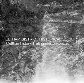
Negative - Photograph, J.A. McDonald, Henley Road at Watsons Creek, Apr. 1961
Henley Road at Watsons Creek looking westerly along centreline from east abutment Early April 1961Record of various Shire of Eltham infrastructure works undertaken during the period of 1952-1962 involving bridge and road reconstruction projects, sometimes with Eltham Shire Council Project Reference numbers quoted. It was during this period that a number of significant improvements were made to roads and new bridges constructed within the shire that remain in place as of present day (2022). In many situations, the photos provide a tangible visible record of infrastructure that existed throughout the early days of the Shire. The album was put together by or under the direction of the Shire Engineer, J.A. McDonald.infrastructure, shire of eltham, bend of islands, cr. charis pelling, henley road, henley road bridge, kangaroo ground, oxley bridge, watsons creek, w.e. wolf, bridge construction, road construction, 1961-04 -
 Eltham District Historical Society Inc
Negative - Photograph, J.A. McDonald, Henley Road at Watsons Creek, Apr. 1961
Henley Road at Watsons Creek looking westerly along centreline from east abutment Early April 1961Record of various Shire of Eltham infrastructure works undertaken during the period of 1952-1962 involving bridge and road reconstruction projects, sometimes with Eltham Shire Council Project Reference numbers quoted. It was during this period that a number of significant improvements were made to roads and new bridges constructed within the shire that remain in place as of present day (2022). In many situations, the photos provide a tangible visible record of infrastructure that existed throughout the early days of the Shire. The album was put together by or under the direction of the Shire Engineer, J.A. McDonald.infrastructure, shire of eltham, bend of islands, cr. charis pelling, henley road, henley road bridge, kangaroo ground, oxley bridge, watsons creek, w.e. wolf, bridge construction, road construction, 1961-04 -
 Stawell Historical Society Inc
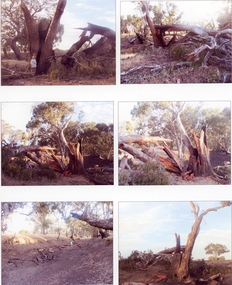
Photograph, Lightning Strike at Sheep Wash Creek in Campbells Bridge 2005 -- Coloured
Series of six colour photographs. Tree after Lightning Strike. Sheep wash Creek 26/1/2005 -
 Ringwood and District Historical Society
Photograph, Roadmaking by McGivens, Warrandyte Rd. just north of Mullum Creek. Easier to camp on job rather than take horses and machinery to and from Croydon. 1920s
Typed below photograph, "Roadmaking in Ringwood in the 1920s." Catalogue card reads, "Roadmaking by McGivens, Warrandyte Rd. just north of Mullum Creek. Easier to camp on job rather than take horses and machinery to and from Croydon."