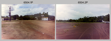
Showing 6805 items matching "river"
-
 Wangaratta Historical Society
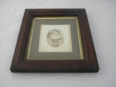
Framed Photo of William Clarke, William Clarke
The photo shows "William Clarke" who owned and operated the first commercial Punt across the Ovens River during the goldrush daysthe photograph shows "William Clarke" who was one of the first pioneers of the township of Wangaratta as it is now known. He also built one of the first hotels in Wangaratta.Brown wooden framed photograph, greyish background with silver surround around photo of William Clarke, one of Wangaratta's foundation pioneers. The wood is from the first punt. He was the owner of the first punt to cross the Ovens river, which he had built for 500 pounds. It was sunk in 1855 after the first bridge across the Ovens river was built.William Clarke1 1839 Wangaratta William Clarke 11 William Clarke 111(my father) Nell Clarke 1884-1965 William Clarke 1 Pioneer of Wangaratta Vic. 1839 This frame is made of oak from the punt he operated over the Ovens River during the goldrush days to Beechworthclarke family, punt, sydney hotel -
 Port of Echuca
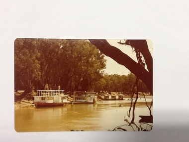
Colour Photograph, Approx.1979
This photo shows a river boat under construction on the eastern bank of the Murray river in the Echuca Port area where the boat shed and swimming pool were located in the 1970's. The boat shed can be seen through the trees but the swimming pool isn't visible. There is another river boat behind, possibly the Canberra.This photograph is of historical and social significance in that it shows the condition of the Murray river in the 1970's at an area used as the local swimming area on the Echuca side of the river. There is a river boat under construction (the frame work shows a bottom and top storey on the boat). This could be the Pride of the Murray. It is difficult to see the name on the river boat behind but it looks like the Canberra. Three houseboats are moored together, a bit further down the river.Colour photograph (post card size) of the Murray river looking north towards the boat shed building. Two river boats are moored by the left bank close to the swimming pool and three house boats can be seen moored further down the river. The river boat in the fore ground is under construction.Printed on reverse:" this paper manufactured by Kodak". Written in blue pen"12B"echuca, port of (riverboats), echuca, port of -
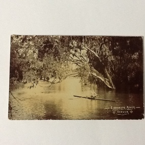
 Lakes Entrance Historical Society
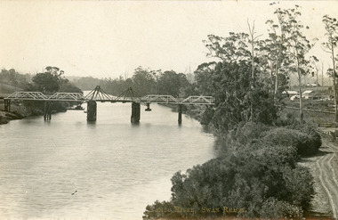
Postcard - Bridges, 1906
Postcard dated 3 December 1913, Bairnsdale, addressed to Mrs Brewer, Metung, Gippsland.Black and white postcard showing wooden lift bridge over Tambo River, Swan Reach, Victoria. Old punt visible at left bank under bank, thick vegetation on right bank, houses in right background above Metung Road.Tambo River, Swan Reachbridges, waterways -
 Orbost & District Historical Society
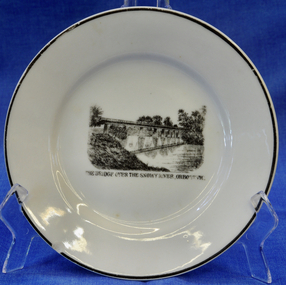
plate
This item is an early souvenir of the local district.Small white plate with black rim. Black and white illustration of the bridge over the Snowy River at Orbost.Back - Made in Orbost. Front - The Bridge Over The Snowy River At Orbost, Vic.plate souvenir snowy-river orbost -
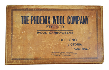 National Wool Museum
Container - Display Case, Phoenix Wool Company Pty Ltd, 1950-1955
The Phoenix Wool Company was started in 1919 by Brigadier-General Robert Smith. The works were located on the Barwon River, near the end of Shannon Avenue; some remnants of the original buildings can still be seen at the site. Phoenix was one of the first to develop the wool carbonising process (the removal of vegetable matter from wool through the use of chemicals) and during its heyday in the 1930s-50s the company operated 24 hours per day and employed a workforce of over 100. The company closed in 1997. This box of carbonised wool samples may possibly have been used by a salesman promoting the activities of the company.Display case, brown cardboard printed with text in black on the lid at the top. Lined in blue. Interior divided into five sections, each containing samples of carbonised wool. There are five labels attached to the inside of the box lid.THE PHOENIX WOOL COMPANY / PTY. LTD. / WOOL CARBONISERS / GEELONG / VICTORIA / AUSTRALIA / TELEPHONE: 2241, GEELONG / CABLE AND TELEGRAPHIC ADRESS: / "PHOEWOOL" GEELONGphoenix wool company pty ltd, wool industry, wool carbonising, barwon river, geelong, company history, brigadier-general robert smith -
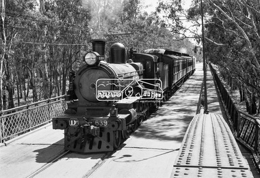 Eltham District Historical Society Inc
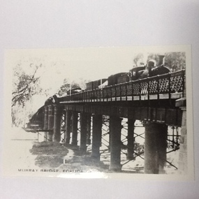
Photograph, VR Commissioner's Special train, steam locomotive D3-639 crossing the Echuca-Moama Road Rail Bridge over the Murray River from Moama, NSW to Echuca, Victoria, 1962
VR Commissioner's Special train, steam locomotive D3-639 crossing the Echuca-Moama Road Rail Bridge over the Murray River from Moama, NSW to Echuca, Victoria. Commissioner Edgar Henry Brownbill on footplate, 1962. Commissioner Edgar Henry Brownbill was in office 1957 to 1967. George Coop advises - "The train on the Eltham/Moama bridge is actually the Commissioner’s Special on one of its inspection tours of the VR rail system. This was a very grand special train with accommodation for the Commissioner and staff in carriages also used once for the Royal Train and other State purposes. You can just see the Commissioner of the day, dressed in his suit and wearing engine drivers gloves, standing in the loco cab doorway. A good ‘hands on’ impression is created amongst local staff if can be seen that the boss is no ‘desk jockjey’. The observation car on the back was originally made for the ’Spirit of Progress’. I climbed up onto the bridge iron plate work to get this view. It was safe enough as the cantilevered pedestrian walkway was still on the east side at the time." "I was resident in Echuca from Jan. ’59 to approx. May ’64. At that time the single Echuca/Moama bridge was a combined road/rail bridge. The rail gauge was 5’3” and still is, I believe, on the new bridge that sits just upstream of the old one. This rail line into NSW has always been 5’3" gauge because it has no connection with any NSW tracks. The old Echuca/Moama bridge, locally called the ‘Iron Bridge’ has, over years, undergone some structural changes. The two lattice iron hoops arcing over the roadway have been raised and lowered and changed design. Presently a pedestrian walkway is cantilevered off the west (or downstream) side of the bridge. It used to be on the eastern side. Guess changes went in when new rail bridge only was built on the eastern side as well." Image dated as c.1963 based on same image in Port of Echuca collection (possibly frame 32 of film) (print 19.5 x 24.5cm) On reverse in pencil: "Brown card" in black pen: "Commissioners special. F. Brown on Footplate. George C.L. Coop c1963". https://victoriancollections.net.au/items/59d575b921ea6e1278d78042 However based on frame no. 10, date set as 1962Digital TIFF file Scan of 35mm Ilford FP3 black and white negative transparencyd3-639, d3-class steam locomotive, echuca-moama road rail bridge, edgar henry brownbill, george coop collection, murray river, vr commissioner's special train -
 Kiewa Valley Historical Society
Photo Framed - Broken Bridge, c1940's
The Tawonga Bridge over the East Kiewa River linked Mt Beauty with Tawonga. It was broken during Vera Hore's lifetime, 1909 - 2000. The bridge over the East Kiewa River enabled people to travel between Mt Beauty and Tawonga. Vera Hore (nee Ryder), the publican of the Tawonga Hotel, took this photo as she was a keen amateur photographer. Vera lived from Nov. 1909 to July 2000.Colored photo of 'Broken Bridge' over the East Kiewa River on Damm's Road with Mt Bogong, with snow, in the background of centre top. Framed with 2 cm wide cream cardboard surrounded by a metal decorated frame. The back has a flap for displaying the photo on a bench or table. On the back, a white sticker inscribed:- "Broken Bridge" / Old Timber Bridge / over East Kiewa River / on Damm's Rd." On the back top left corner hand written:- "Vera Hore"tawonga bridge; vera hore; east kiewa river; tawonga hotel -
 Federation University Historical Collection
Map - Geological, Tallangatta, New South Wales: 1:250,000 Geological Series, SJ 55-3, 1966, 1966
Compiled by the Geological Survey of N.S.W., Division of Regional Geology. Topographical base compiled from Snowy Mountains Hydro Electrical Authority, Department of Lands, County maps and Snowy Lease Map. Other sheet adjoin this map. There are 13 formation sections grouped into 9 - Quaternary, Tertiary, Middle Devonian, Lower to Middle Devonian, Lower Devonian, Upper Silurian, Silurian, Upper Ordovician and Ordovician.Large coloured map showing geological features, faults, bores, rivers and mineral deposits.Scale of map, longitude and latitude, river names. "Tallangatta 1:250,00" written in black pen.tallangatta, new south wales, geological survey, topographical base, snowy mountains hydro electrical authority, department of lands, snowy lease map, department of mines, quaternary, tertiary, middle devonian, lower to middle devonian, lower devonian, uper siluran, silurian, upper ordovician, ordovician -
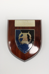 National Vietnam Veterans Museum (NVVM)
Plaque - Presented plaque
One of several items donated in memory of Sergeant Trevor J Nicholson, who served in Royal Australian Armoured Corps, C Squadron and B Squadron 1st Armoured Regiment, 1969-70, Vietnam.A wooden plaque with black, blue and gold shield shaped insignia of 12/16 Hunter River Lancers depicting an elephant and crossed banners and dedication.To WO2 Trevor Nicholson/From P.M.C and Members/12/16 HRL/Sergeants Mess 18.8.1993 Hunter River Lancers/12/16 Hunter River Lancers12/16 hunter river lancers, 4410261 wo2 trevor nicholson., trevor nicholson, 1st armoured regiment, nicholson, shield -
 Lakes Entrance Historical Society
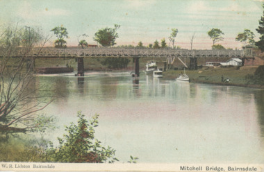
Postcard - Mitchell river, Port of Bairnsdale Victoria, 1900 c
Wharf on the left side of the image was known as Top Wharf or Upper Wharf. Small house seen on eastern bank was home. Small house seen on eastern bank was home of Mr Healy Orchadist who sold fruit and grafted fruit trees. Big tree next to house was an enormous oak .Information from G ScarceTinted postcard showing first bridge over the Mitchell river, steamers and other boats at wharf on western bank known as Port of Bairnsdale Victoria. Also black and white photo of same view W.R. Lidston Bairnsdale Mitchell River Bairnsdaleboats and boating, rivers -
 Kew Historical Society Inc
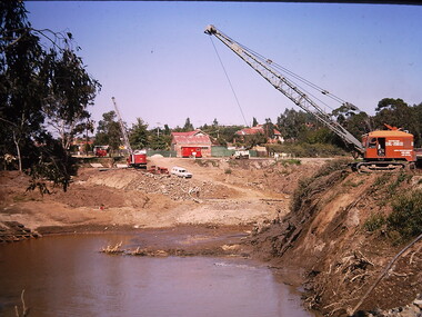
Photograph - Construction of the Eastern Freeway (F19), Ron Setford, March 1972
Ron Setford and his wife Grace Setford lived in Tanner Avenue, East Kew, from c.1946 to c.1995. A keen photographer, he recorded the changing face of Kew over a 20 year period. Apart from 30 photographs of built structures and places in Kew dating from 1960 and 1961, 145 of his 35mm colour slides chronicle the development of the F19 (later renamed Eastern) Freeway through the Yarra Valley in Kew over a five year period from c.1972 to c.1977. This important collection was donated to the Society by his granddaughter in 2025.This collection of 175 35mm slides is of local and statewide significance, owing to its subject matter, particularly the major development of road transport infrastructure during the 1970s with the construction of the Eastern Freeway. The photographer also took care to annotate and date most of his slides which enable the researcher to pinpoint temporal and spatial locations.Photograph of works involved in construction of the F19 (now Eastern) Freeway. The photo shows works to divert the route of the Yarra River in Kew in order to construct a section of the F19 Freeway. "Eastern Freeway / River diversion works / Mar 72"ron setford, eastern freeway, f19 freeway -
 Kew Historical Society Inc
Photograph - Construction of the Eastern Freeway (F19), Ron Setford, March 1972
Ron Setford and his wife Grace Setford lived in Tanner Avenue, East Kew, from c.1946 to c.1995. A keen photographer, he recorded the changing face of Kew over a 20 year period. Apart from 30 photographs of built structures and places in Kew dating from 1960 and 1961, 145 of his 35mm colour slides chronicle the development of the F19 (later renamed Eastern) Freeway through the Yarra Valley in Kew over a five year period from c.1972 to c.1977. This important collection was donated to the Society by his granddaughter in 2025.This collection of 175 35mm slides is of local and statewide significance, owing to its subject matter, particularly the major development of road transport infrastructure during the 1970s with the construction of the Eastern Freeway. The photographer also took care to annotate and date most of his slides which enable the researcher to pinpoint temporal and spatial locations.Photograph of works involved in construction of the F19 (now Eastern) Freeway. The photo shows works to divert the route of the Yarra River in Kew in order to construct a section of the F19 Freeway. "Eastern Freeway / River diversion works / Mar 72"ron setford, eastern freeway, f19 freeway -
 Orbost & District Historical Society
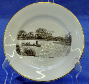
souvenir plate, Between 1925 and 1941
Illustration on plate is a family fishing party aboard the "Ripple" built by George Matthew Winchester. Shows Ethel (mother) with Lindsay Smooker on her knee. Harry, Elsie, Anita and H. Hermann about 1941. The Winchesters lived in Marlo and built boats near the Marlo hotel. The "Ripple" built by George Winchester at the age of 18 years was the first boat built by him. It was built in 1908. It has been noted in a profile of George Winchester done by his Daughter Olive Hunt (née Winchester) that was completed one year before her death in 2002.The Winchester family is a prominent local family.The Winchesters lived in Marlo and built boats near the Marlo hotel. This item is an example of a souvenir item made especially for Orbost.Very small white souvenir plate. Gold-rimmed with black illustration of people in a boat on the Snowy River.Front-Snowy River Orbost Back-Melba Bone China Guaranteed Made in Englandplate souvenir snowy-river orbost melba-china -
 Port of Echuca
A black and white photographic postcard, Between 08/1906 - 10/1906
Photographic Postcards were very popular in the early 20th century and this shows the Campaspe river, Echuca in flood. The high water mark is exemplified by having the rower on the water. The water has inundated the surrounding bush with trees partly submerged along the right hand side of the photograph.Rowing clubs were popular in towns along the Murray river and this picturesque scene of the Campaspe river , Echuca in flood shows a man rowing a racing scull down the river.Black and white photographic postcard showing the Campaspe river, Echuca, in flood, with a man rowing a racing scull.On face : "Campaspe River, Echuca". On reverse: printed in ink :" Post Card. This space may be used for correspondence. For address only. Place penny stamp here." In pencil is written: "Aug Sep Oct 1906 Flood" "Donation H V Evans 85 Fullers Rd Chatswood NSW." " Echuca Regional Library" is stamped but has been crossed out in pen.campaspe river, echuca, echuca flood, 1906, rowing, echuca -
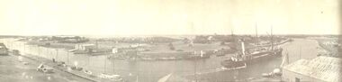 Port Fairy Historical Society Museum and Archives
Photograph
Black and white panoramic photograph of the Moyne rivership, boat, sea, river, ss casino -
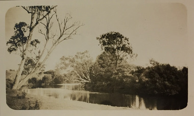 Kew Historical Society Inc
Photograph - Yarra River, Kew, 1924
Henry Beater Christian (1886-1962) , was a descendant of one of the earliest settler families in Kew. Employed at the Kew Asylum as a 'public servant', he was a skilled amateur photographer, photographing numerous scenes in Kew and on his travels around Victoria. The majority of his photographs date from 1916 to 1929. His finest photographs are housed in two photograph albums. A dated early photograph of the Yarra River at Kew.Digital copy of a photograph from page 1 of the 47-page photograph album containing 261 gelatinous silver images, loaned by Diane Washfold with permission given to digitise and hold a copy in our collection. The image is a view of the Yarra with remnant large Eucalypts on either side of the river."Yarra River Kew 1924"henry beater christian (1886-1962), landscape photography, kew (vic.) — yarra river, christian-washfold collection, photograph albums -
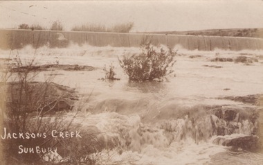 Sunbury Family History and Heritage Society Inc.
Photograph
The river in flood is the Jacksons Creek. This section of the river with the waterfall is downstream from the town of Sunbury.A sepia photograph in post card format of a river with waterfalls in flood.rivers, jacksons creek, sunbury -
 Orbost & District Historical Society
black and white photograph, first half 20th century
This is the Dalgety bridge across the Snowy River. It is a steel construction.The first bridge over the river was constructed in 1888. There was a punt across the river before the bridge was built . Dalgety is a small service centre, located on the Snowy River approximately 235 km from Orbost. It was an early consideration for the site of Australia,s capital city. The Dalgety Bridge over the Snowy River has been an important item of infrastructure in the history of New South Wales for over 110 years. It was designed by noted bridge engineer J. A. McDonald,and was a technically sophisticated bridge structure for its time. This is a pictorial record of a significant structure on the Snowy River.A small black / white photograph of a large bridge over a river.bridge-dalgety-snowy-river -
 Port of Echuca
Photograph, Original photo C.1910. Copy 1984
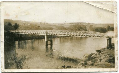
This photograph comes from the Dowell collection. Related to P000202. At the turn of the 20th century, the railway line carried produce from southern New South Wales and the Riverina to Melbourne. Goods trains were a very important mode to transport to our region and industrialisation of Echuca. Photograph of the Murray bridge at Echuca at low river with a goods train crossing the bridge. Image is seen from bank facing north from Echuca.Recto :"MURRAY BRIDGE Echuca"; Verso: "C.1910" "Low river"dowell collection, murray river bridge , echuca, murray bridge, echuca, steam engine goods train, railway, transportation, industrialisation -
 Glenelg Shire Council Cultural Collection
Negative - Negative - Glenelg River, Victoria, 1934
Part of a collection of photographs taken by Zillah Maschmedt in 1934. Zillah was a teacher from South Australia.Negative for black and white photo. Glenelg River and bridge at Nelson, Victoria.zillah maschmedt, photography, glenelg shire, river -
 Kew Historical Society Inc
Photograph - Yarra River, Kew, 1924
Henry Beater Christian (1886-1962) , was a descendant of one of the earliest settler families in Kew. Employed at the Kew Asylum as a 'public servant', he was a skilled amateur photographer, photographing numerous scenes in Kew and on his travels around Victoria. The majority of his photographs date from 1916 to 1929. His finest photographs are housed in two photograph albums. A dated early photograph of the Yarra River at Kew.Digital copy of a photograph from page 1 of the 47-page photograph album containing 261 gelatinous silver images, loaned by Diane Washfold with permission given to digitise and hold a copy in our collection. The image is a view of the Yarra with a horse on the other side of the river standing near the solitary large tree."Yarra River Kew 1924"henry beater christian (1886-1962), landscape photography, kew (vic.) — yarra river, christian-washfold collection, photograph albums -
Wangaratta Art Gallery
Painting, Ailsa Seargent, The Junction, 1969
Rural City of Wangaratta Collection.A rural river landscape painted in blues, greens and browns.wangaratta art gallery, ailsa seargent, painting, landscape, river -
 Orbost & District Historical Society
black and white photograph, first half 20th century
The seed bean industry was a major industry in the Orbost district for the first half of the 20th century. The total area sown with beans for seed at Orbost was estimated to be about 1000 acres. Fisher Bros, grew or supervised the growing of approximately one quarter of the bean seed produced at Orbost, and, in addition, prepared for market and sold a considerable quantity for other growers. From Newsletter February 2015 : "the Fishers took over the old Butter Factory in Lochiel Street. They had sorting tables there in the 1920s. In Orbost, the Fishers had a Shell fuel depot at the back of the bean factory. The Fishers were very enterprising people, very smart. One of their uncles is supposed to have invented the knot that was used to tie the sheaves of hay in the fields. At their Lochend Barn, they had a Blackstone engine which ran on oil. They used to light a fire under it and hot it up to start it. This engine drove all the bean machinery in the barn" The seed bean industry was a major industry in the Orbost district for the first half of the 20th century. the Fisher Brothers were a significant part of that industry.A black / white photograph tajen from a river bank. On the right behind some trees is a barn. On the left between tres is a small building. Reflections can be seen in the water.on back - "Snowy River, Fisher barn on right. Mary Gilbert"bean-industry fisher-beans snowy-river -
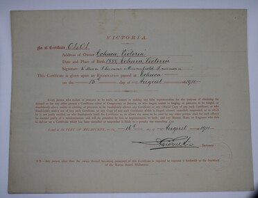 Port of Echuca
Certificate (Item) - Certificate of Competency - Master, William Tomas Mansfield Freeman, 16-8-1910
From the 1870s Captains were required to sit a steamship competency exam to operate a vessel on the Murray River. William Tomas Mansfield freeman was born in Echuca in 1888.Valid on River Murray & Tributariescaptains, murray river, marine board of victoria, certificate of competency, marine act 1890, master -
 Flagstaff Hill Maritime Museum and Village
Furniture - Table, Ralph Speirs, Warrnambool Triton Woodwork Club, 2009
The turpentine timber used to construct this table was originally used to build the second Hopkins River bridge in 1895. That long timber truss road bridge was built across the river close to the river mouth. The first Hopkins River bridge was built in 1862. That bridge was replaced by the second bridge, built in 1895. In 2001 the new third bridge was built to replace the 1895 bridge, in a design to look similar to the 1895 bridge. The timber from the second bridge was recycled to make this hall table, a cheeseboard presented to the Mayor at that time, and other mementos. The plaque attached to the table states the table was made in 2009 by Ralph Speirs, Warrnambool Triton Woodwork Club. The table is significant for its connection with the second Hopkins River bridge, built in 1895. The timber used to make the table has been recycled from the second Hopkins River bridge that was destroyed to make way for the new, third bridge. The Timber Truss Hopkins River Bridge was classified with State Significance on 16th April 1996, being the oldest of six surviving timber truss bridges in Victoria and the most intact timber road bridge of any type for its size and age. Its design was unique within Australia. It was the largest timber bridge built in Victoria during the 1890s. The bridge was of importance to the economical development of the region, opening up access to allow ease of trade and social connections between the eastern region of southwest Victoria and the town, later city, of Warrnambool and regions further west.Table made from turpentine timber. The timber was recycled from the second Hopkins River Bridge after the bridge was destroyed. The bridge was built in 1895. The table was constructed in 2009 by Ralph Speirs, Warrnambool Triton Woodwork Club. The front corners of the table are rounded and bthe back corners are straight. A plaque with eight rows of text is attached to the table."TABLE BUILT FROM TURPENTINE TIMBER RECYCLED FROM THE SECOND HOPKINS RIVER BRIDGE, BUILT IN 1895 AND DEMOLISHED IN 2000 TO BE RPLACED BY THE PRESENT THIRD BRIDGE. CONSTRUCTION BY RALPH SPEIRS, MEMBER OF WARRNAMBOOL TRITON WOODWORK CLUB, IN 2009"flagstaff hill, warrnambool, hopkins river, bridge, 1895, 2009, ralph speirs, warrnambool triton club, domestic furniture, table, hall table, side table, timber table, hall stand, furniture -
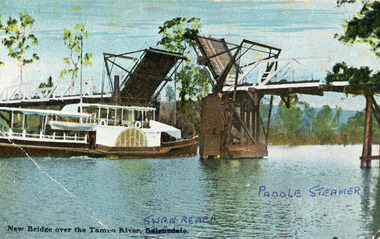 Lakes Entrance Historical Society
Photograph - Bridges, V S M Series, 1920 c
Hand tinted postcard showing Paddle Steamer 'Tanjil' passing upstream under the open Swan Reach Bridge on the Tambo River, East Gippsland, Victoria.New Bridge over the Tambo River Swan Reach Paddle Steamerships and shipping, waterways, bridges -
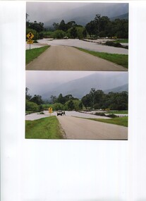 Kiewa Valley Historical Society
Photos - x2 Damms Road River Crossing
Damms Road river crossing after the c1993 floods of the Kiewa River. The old bridge was inundated, later to be washed away.The Kiewa River flooded in 1993 at Damms Road when the old bridge was washed away.2 coloured photos of the Kiewa River in flood at Damms Roadkiewa river flooding, bridge at damms road -
 Bendigo Military Museum
Photograph - 4th Field Survey Squadron – Operation NERVOSE 85 Reconnaissance, Northern Territory, 1985
This is a set of 13 photographs taken in 1985* during reconnaissance of locations in regions of the Northern Territory. Later that year, Operation NERVOSE 85 was mounted by 4 Fd Svy Sqn in the EAST ARNHEM, VICTORIA RIVER DOWNS AND DALY WATERS areas of the Northern Territory from 26 May to 18 Sep 85. The aim of Operation NERVOSE 85 was to finalise the horizontal and vertical control for mapping at a scale of 1:50,000, to field check 40x 1:50,000 preliminary maps and to obtain mapping photography in support of the RAAF TINDAL redevelopment project. *Note –These photos were most likely taken in 1985, contrary to the ‘1987’ date annotated on the negative sleeves. The Op NERVOSE 85 Project Report available on RASVY’s web site lists a nominal roll of personnel. Photos of 4 Fd Svy Sqn taken in 1985 and 1987 provide names of posted personnel. Several personnel identified in these photos were posted to 4 Fd Svy Sqn in 1985, not in 1987.This is a set of 13 photographs taken during 4th Field Survey Squadron’s reconnaissance of Operation NERVOSE 85 locations in the Northern Territory in 1985. The colour photographs are on 35mm negative film and are part of the Army Survey Regiment’s Collection. The photographs were scanned at 96 dpi. .1) to .4) - Photo, colour, 1985. Unknown location in the Northern Territory. .5) - Photo, colour, 1985. Unidentified personnel in the back of a police vehicle. .6P to .12) - Photo, colour, 1985. Unknown location in the Northern Territory. .13) - Photo, colour, 1985. L to R: Possibly MAJ A. Vickers RE - UK Exchange Officer from Army Svy Regt, unidentified officer. .1P to .13P – There are no personnel identified. ‘1987 OP NERVOSE – RECON PHOTOG.’ annotated on negative sleeve.royal australian survey corps, rasvy, 4 fd svy sqn, op nervose 85 -
 Lakes Entrance Historical Society
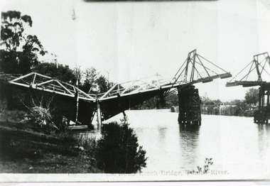
Photograph - Bridges, Bulmer H D, 1925
Swan Reach Bridge collapsed 10.00 am 16 November 1925Black and white photograph showing collapsed bridge over the Tambo River, bridge collapsed at eastern end. Photo looking downstream. Two people on landing on far right bank behind right hand bridge pylon. Thick vegetation on bank. Swan Reach VictoriaSwan Reach Bridge on the Tambo Riverwaterways, boats and boating, disasters -
 Kew Historical Society Inc
Photograph - Construction of the Eastern Freeway (F19), Ron Setford, March 1972
Ron Setford and his wife Grace Setford lived in Tanner Avenue, East Kew, from c.1946 to c.1995. A keen photographer, he recorded the changing face of Kew over a 20 year period. Apart from 30 photographs of built structures and places in Kew dating from 1960 and 1961, 145 of his 35mm colour slides chronicle the development of the F19 (later renamed Eastern) Freeway through the Yarra Valley in Kew over a five year period from c.1972 to c.1977. This important collection was donated to the Society by his granddaughter in 2025.This collection of 175 35mm slides is of local and statewide significance, owing to its subject matter, particularly the major development of road transport infrastructure during the 1970s with the construction of the Eastern Freeway. The photographer also took care to annotate and date most of his slides which enable the researcher to pinpoint temporal and spatial locations.Photograph of works involved in construction of the F19 (now Eastern) Freeway. The photo shows works diverting the former river bed of the Yarra near Kilby Road and Willsmere Road, Kew."Eastern Freeway / Old River Bed / Kilby-Willsmere Rd"ron setford, eastern freeway, f19 freeway