Showing 1522 items
matching streetscape
-
 Bendigo Historical Society Inc.
Document - LILLIAN DOBLE COLLECTION: SNAPSHOTS OF BENDIGO SCENES
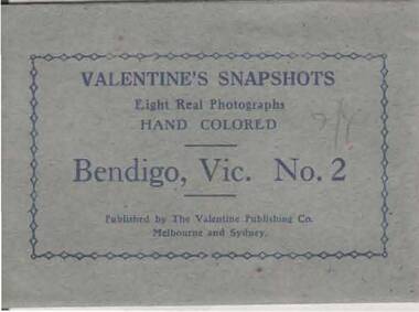
Envelope with eight snapshots of Bendigo scenes. Personal wartime memorabilia. 1942 -1948, of Lillian Doble. Small blue envelope printed on the front with: Valentine's snapshots. Eight real photographs hand colored Bendigo, Vic No.2. Published by the Valentine Publishing Co. Melbourne and Sydney. In pencil handwritten, 2/4. On reverse: Printed in Great Britain. Inside: eight sepia snapshots that have been coloured, labelled on the front of each snapshot - No. 11 Conservatory Gardens, Bendigo; No 12 Rosalind Park, Bendigo; No.13 Lake Weeroona, Bendigo; No.14 View Point, Bendigo; No. 15 The Coinservatory Gardens, Bendigo; No.16 Deborah Goldmines looking towards Bendigo; No.17 Rosalind Park Gardens, Bendigo; No.18 The Mall, Bendigobendigo, streetscape, world war 2, lillian doble, rosalind park gardens, conservatory gardens, lake weeroona, view point, deborah gold mine, the mall, bendigo 1942-1948 -
 Ballarat Heritage Services
Digital photographs, fiveways (Denmark, Studley Park, Princess, High, High South) from Kew Junction (Cotham and High), c2017
Digital images of Kew Junction.kew, kew junction, five ways, streetscape, cotham road, high street, road, shop, shopping centre, strip shopping centre, commercial -
 Ballarat Heritage Services
Digital photographs, L.J. Gervasoni, Snow in the Main Street of Daylesford, Victoria, c2012-2016
Digital images of snow in Daylesford. vincent street, daylesford, shops, streetscape, snow, weather, climate, winter, daylesford museum, daylesford police station, daylesford hotel -
 City of Ballarat Libraries
Photograph - Card Box Photographs, Looking west along Sturt Street, 1915
View of Sturt Street looking west from the Ballarat Homecoming publication. Buildings of interest include the Ballarat Town Hall, City Mutual Building and Marks & Co. You can also see both horse drawn cabs and the electric tram.sturt street, ballarat, ballarat town hall, city mutual, marks & co, electric tram, horse drawn cabs, streetscape, public, commercial, ballarat homecoming -
 City of Ballarat Libraries
Photograph - Card Box Photographs, Ballarat Town Hall & Sturt Street circa 1936
You can see the Town Hall and both sides of Sturt Street looking east. Some of the business include Crockers and Tunbridges.ballarat town hall, sturt street, streetscape, electric tram, garden, crockers, tunbridges, vehicle, building, public building, commerical -
 The Beechworth Burke Museum
Photograph, 1983
These five images, photographed in 1983, depict locations in Ireland that Ned Kelly's father, John "Red" Kelly may have frequented. John Kelly was born on the 20th of February 1820 and worked as a laborer in Ireland. His parents were named Thomas Kelly and Mary Cody. He had a fresh complexion, large head and reddish coloured hair. John Kelly was sentenced in Tipperary, Ireland for the theft of a pig and received 7 years in Van Diemen's Land (now known as Tasmania). He sailed on the ship "Prince Regent" and arrived in VDL on the 2nd of January 1842 with 11 other convicts. John Kelly completed his sentence and moved to Beveridge in Victoria where he met and married Ellen Quin. The couple had 7 children, one of these is Ned Kelly the Bushranger. He died at the young age 46 in 1866. County Tipperary is a county located in Ireland in the province of Munster. It was established in the early thirteenth century, shortly after the Norman invasion of Ireland. These photographs, taken by an unidentified photographer, show the streetscape of Tipperary, the remains of a coachyard and stables, a saddlery yard and a fashion shop. These images are part of the Burke Museum's Kelly album which are of great use to researchers in the reconstruction of the Kelly story. Images like these, which portray an area which John Kelly resided in his youth, have research potential in reconstructing the conditions and quality of life for the Kelly parent. However, these images are not only important for their connection to the Kelly story but also for what they can provide and reveal for Ireland in the 1980s.A collection of five colour rectangular photographs printed on matte photographic paper10269.1 Reverse: TOWNSEND ST. BANBRIDGE / CO. DOWN N. IRELAND 10269.1 Reverse: TOWNSEND ST. BANBRIDGE / CO. DOWN N. IRELAND 10269.3 Reverse: REMAINS OF COCHYARD AND STABLES / BANBRIDGE CO. DOWN / FREQUENTED BY NED KELLY'S / FATHER 10269.4 Reverse: STABLES AND SADDLERY YARD / THROUGH ENTRANCE FROM / SHOP. PHOTOGRAPH 3 / 10269.5 Reverse: ENTRANCE TO STABLES AND / SADDLERY. FASHION'S SHOP TO LEFT / OF ENTRANCE WAS THE ORIGINAL / SADDLERY SHOP. / BANBRIDGE CO. DOWN / 3kelly album, kelly family, ned kelly, northern ireland, irish heritage, tourism, john kelly, john 'red' kelly -
 Canterbury History Group
Photograph - Maling Road shops and environs, Jan Pigot and Stuart Warmington, 1993
Photographs recording interiors and exteriors of Canterbury shops, shopkeepers and Federation details of architecture. Section A -Maling Road shops, south side - 87 coloured photographs taken by Jan Pigot in 1993.|Section B- Maling Road shops, north side - 88 coloured photographs taken by Jan Pigot in 1993.|Section C- Bryson Street shops - car park - 4 coloured photographs taken by Jan Pigot in 1993-4.|Section D- Canterbury shops and streetscapes - 76 coloured photographs taken by Stuart Warmington c.1995.|Section E- Maling Road shops, north side - 27 coloured photographs taken by Stuart Warmington c. 1995.|Section F- Maling Road shops, north and south side - 24 coloured photographs taken by Stuart Warmington 1995.|Section G- Plaques and Signs in Canterbury - 14 coloured photographs taken by Jan Pigot c. 1994.maling road, canterbury, shops, shopkeepers, hel> f, petroro> tony, bourke> francis, d'annibale> grace, buckley> june, buckley> ken, godfrey, greengrocers, newsagents, gift shops, furniture restorers, florists, nurseries (plants), cake shops, cafes, butchers -
 City of Ballarat Libraries
Photograph - Card Box Photographs, Corner of Sturt Street and Lydiard Street North circa 1880
sturt street, lydiard street north, ballarat, alex marks, craigs royal hotel, cobbs corner, streetscape, buildings, public buildings, commerical, streetlamp, flegeltaub -
 City of Ballarat Libraries
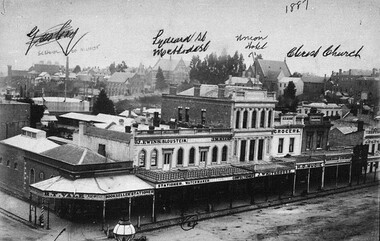
Photograph - Card Box Photographs, South Side of Grenville Street, Ballarat 1887
Shown in the photograph are R.T. Vale Bookseller, J. Ewins Stationer, Bloustein Watchmaker, J.M. Klug Confectioner, Unicorn Hotel, H.D. Mundie Grocers, Hammond Booksellers & Stationers and Richards Photography.grenville street, buildings, streetscape, commerical, r.t. vale bookseller, j. ewins stationer, bloustein watchmaker, unicorn hotel, j.m. klug confectioners, h.d. mundie grocers, hammond booksellers & stationers, richards photography -
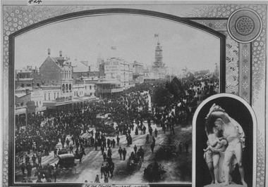
 Bendigo Historical Society Inc.
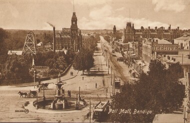
Photograph - PALL MALL, BENDIGO, c1903-1918
Two identical post cards: 'Pall Mall', Bendigo streetscape, fountain in foreground, horse-drawn cab, cable trams, Hustler's Royal Reserve Mine, Post Office, Henderson & Goodisson Beehive sign clearly visible. Physical description: loose photograph, sepia. Inscriptions markings: on back of photo - The 'Valentine & Sons' Publishing Co., Ltd., Melbourne. POST CARD. Printed in Great Britain. This space to be used for communication. The Address only to be written here. On front - Pall Mall, Bendigo. Also 300.336 then the letters JK in a circle. On back of the second postcard: Royal Historical Society of Victoria, Bendigo Branch. Hustlers Royal Reserve No.2 data. Hustlers Royal, Pall Mall, Bendigo. RSL Memorial Hall now occupies site. Depth of Shaft - 1,660 feet. Formed 1885; Closed 1917. Poppet Legs - Steel, 60 feet high. Winding engine: First motion, 24 in. Cylinders, 10ft. Drums. Gold yields - 10,262 oz. Dividends 3,200 pounds.The Valentine & Sons' Publishing Co., Ltd., Melbournebendigo, pall mall, rhsv, hustlers royal reserve -
 Eltham District Historical Society Inc
Photograph - Digital Photograph, Alan King, St Andrews Hotel, 2 February 2008
The c1860 St Andrews Hotel, with the c1930 additions, and the Canary Island Palm, and the surrounding site to the title boundaries are historically, socially and aesthetically significant to the Shire of Nillumbik. The St Andrews Hotel is historically significant because it may have given its name 'St Andrews' to the town (another suggestion is that the name came from St Andrews church) and for its connection to Ewen Hugh Cameron (1831-1915) the prosperous local farmer, member of the Eltham Roads Board/Shire Council and local MP. It is also significant as the oldest hotel building in the former Shire of Eltham, as one of the few surviving buildings connected with the Caledonian goldfields era and as one of a handful of early structures to have survived the 1960s bushfires; the additions and alterations to the hotel reflect its long life. The hotel is socially significant because it has served as an important meeting place for more than 160 years. The Canary Island Palm is historically significant as a rare example of exotic tree planting in this rural area. The tree is aesthetically and historically significant as a local landmark and for its contribution to the streetscape and landscape value. Covered under Heritage Overlay, Nillumbik Planning Scheme. Published: Nillumbik Now and Then / Marguerite Marshall 2008; photographs Alan King with Marguerite Marshall.; p71This collection of almost 130 photos about places and people within the Shire of Nillumbik, an urban and rural municipality in Melbourne's north, contributes to an understanding of the history of the Shire. Published in 2008 immediately prior to the Black Saturday bushfires of February 7, 2009, it documents sites that were impacted, and in some cases destroyed by the fires. It includes photographs taken especially for the publication, creating a unique time capsule representing the Shire in the early 21st century. It remains the most recent comprehenesive publication devoted to the Shire's history connecting local residents to the past. nillumbik now and then (marshall-king) collection, st andrews hotel -
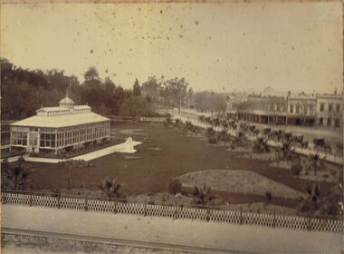 Bendigo Historical Society Inc.
Photograph - CONSERVATORY GARDENS, PALL MALL, BENDIGO
Black and white image (faded to almost sepia colour) mounted on back cover of photo album. Image shows Conservatory building on LH side, Bridge Street looking North West on RH side of image. Conservatory gardens are laid out alongside fence lines, and Conservatory building perimeter. Small palm trees inside fence line alongside Bridge Street, and Bull Street. On kerbside of Bridge Street is a line of 13 horse drawn hansom cabs. On opposite side buildings: Fire Brigade Hotel, W.H. Oakley Undertakers, Dimond Bros. Photo Enlargers, Black Swan Hotel. Gardens are fenced in iron fencing, underneath is placed a (temporary?) small trellis fence. Approx 1880’s?bendigo, streetscape, conservatory gardens, bridge st., bendigo, conservatory gardens, bull street, bridge street, black swan hotel, fire brigade hotel, w.h. oakley undertakers, dimond bros. photo enlargers, hansom cabs -
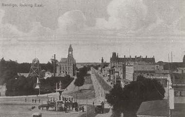 Bendigo Historical Society Inc.
Photograph - BENDIGO LOOKING EAST ALONG PALL MALL, c1915
Black and white photograph taken from the City Family Hotel Tower, looking along Pall Mall towards White Hills, Showing Alexandra fountain, toast rack tram, 1903 tram, Hustler's Royal Reserve Mine, Post Office, Law Courts behind, tram track, School of Mines tower, Shamrock Hotel and other businesses, The Beehive, Pikes Building and verandah of building in foreground. Inscriptions: 'Bendigo, looking East' in TLH corner. History: photographic copy in black and white of a colour tinted postcard, printed c1915. Copied c1970place, streetscape, pall mall, photograph, photography, bendigo, alexandra fountain, toast rack tram, bendigo law courts, bendigo post office, bendigo school of mines, beehive building, hustler's royal reserve mine -
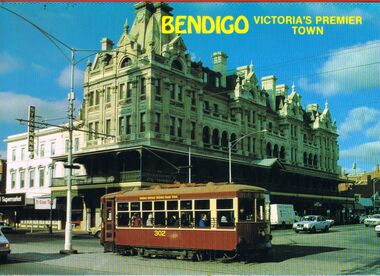 Bendigo Historical Society Inc.
Postcard - BENDIGO POST CARD FOLDER
Bendigo post card folder '6 tear off postcards, vue pack Bendigo, Victoria's Premier gown' Coloured foldout series. Shamrock Hotel with tram outside; Bendigo Hargreaves Mall with walkway and gazebo; Bendigo Easter Parade with Sun Loong outside Law Courts Pall Mall; Fortuna ( Army Survey Regiment ) ; Central Deborah Gold Mine and talking tram ; Alexandra Fountain.NCVbendigo, streetscape, post card folder, bendigo, tourism, postcards, fortuna, alexandra fountain, central deborah gold mine, shamrock hotel, sun loong, bendigo easter fair, mall. -
 Bendigo Historical Society Inc.
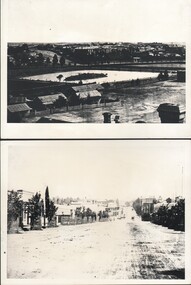
Photograph - WES HARRY COLLECTION: BENDIGO ASYLUM AND LOWER DAM, (a)1876, (b) 1872
(a) Photograph taken from the Camp Hill State School Tower, looking north across the lower dam of Rosalind Park to the Bendigo Asylum ( Ann Caudle Centre) in the background, Photograph also shows the house where Wes Harry was born (27/02/1902). (b) Photograph of Mitchell Street Sandhurst, taken from about Mollison Street and with the Masonic Hall in the background. Two of the businesses pictured are C.H. Hoffmeyer on the left hand side and John Patterson's Drapery on the right.(a) C. Nobleton, (b) N. J. Caireplace, streetscape, mitchell street, bendigo, camp hill, lower dam, bendigo asylum, wes harry, mitchell street , c. h. hoffmeyer, john patterson, c. nobleton, n. j. caire -
 City of Ballarat Libraries
Photograph, 8 Hours Day Procession, Ballarat circa 1893
This procession was conducted in Sturt Street. The picture insert is of the statue 'Flight from Pompeii'. Some of the buildings seen in the photo are Mechanics Institute, Town Hall and the Unicorn Hotel.celebrations, 8 hours day, streetscape, buildings, commerical, public, town hall, mechanics' institute, unicorn hotel, statue, flight from pompeii, sturt street, ballarat -
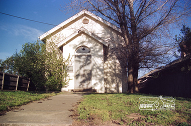 Eltham District Historical Society Inc
Photograph, Doug Orford, Eltham Courthouse, 730 Main Road, Eltham, 1985, 1985
This building is a fine example of a very early small brick country court house which retains its furnishings and has important associations with the early history of the Eltham township. It was used for Eltham Road Board meetings in the 1860s and later to provide additional school accommodation. It is the oldest public building remaining in Eltham and forms an important group in historic and streetscape terms with the adjoining former police residence. The survival of the furnishings (of unknown origins) is of particular significance given the building's age. This building, and the former police residence beside it, were constructed as a result of a petition by five Eltham residents in 1857. The nearest police were at Heidelberg eight miles away or at the Caledonia Diggings 21 miles away. After the construction of the Court of Petty Sessions at Eltham in 1859-60 (which was designed by the Public Works Department and built by a Mr Duncan for a cost of 536 pounds), it was used for a variety of purposes. Eltham Road Board meetings were held there until 1868 when the board was transferred to Kangaroo Ground and as the Road Board Secretary's office, until this was transferred to Wingrove Cottage in 1867. It was used as an overflow for the Dalton Street School in 1875. According to National Trust records, the Eltham Court House is a relatively rare building type. There are only six other known examples of similar small brick country court houses in the state which have small projecting entry porches and a gabled form. Roll of 35mm colour negative film, 7 stripsFuji 100Neltham, eltham courthouse, main road -
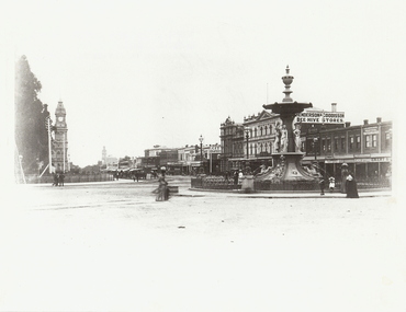 Bendigo Historical Society Inc.
Photograph - ALEXANDRA FOUNTAIN
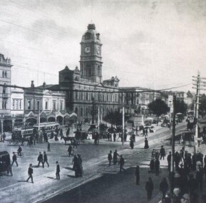
Black and white photograph. Alexandra Fountain, Pall Mall, Post Office, 2nd Shamrock Hotel. Bendigo School of Mines, Beehive Stores, Fence along Pall Mall. Horse cabs along Pall Mall. Men, women and children. Women wearing full length dresses. Inscriptions: in image - 'Henderson & Goodisson', 'City Drapery', 'Melbourne Cash Store', J Edwards Practical Watchmaker', ':Emery', 'A Lannduff', Karl Van Damme'. On back - rubber stamp, purple 'Royal Historical Society of Vic, Bendigo Branch, Dudley House, 60 View Street, Bendigo'.place, streetscape, alexandra fountain, photograph, photography, bendigo, alexandra fountain, pall mall, shamrock hotel, bendigo school of mines, beehive store, bendigo post office, bendigo clock, bendigo post office clock, bendigo citizens -
 Ringwood and District Historical Society
Book, Bryce Raworth, Heritage Impact Assessment - 1 Bedford Road, Ringwood, Victoria. Application for permit - Proposed Redevelopment - July 2021, 2021
A4 size wire-bound book compiled by Bryce RaworthINTRODUCTION: This heritage impact assessment (HIS) was prepared at the request of the City of Maroondah, the owner of the subject property at 1 Bedford Street (sic), Ringwood. It relates to a proposal to demolish the existing shop on the site and construct a multi-storey car park incorporating a commercial tenancy at the lower levels. It reviews the significance of the existing building on the site and the contribution it makes to the surrounding streetscapes, then comments on the heritage impacts of the proposed demolition in the context of the significance of the place and broader considerations. This office has previously provided an Historical Overview of the subject site (June 2020) and this assessment draws upon that previous research and analysis. The report has been prepared by Guy Murphy and Bryce Raworth. CONCLUSION: The proposed demolition of the former Blood Brothers Store at 1 Bedford Street (sic), Ringwood and the construction of a multi-storey car park on the enlarged site will result in the loss of some significance to the Heritage Overlay. The degree of loss is moderated by the partial intactness of the store, its modest character and the loss of its original setting, as well the proposal to implement a heritage interpretation strategy for the site. When considered in the context of the broader range of urban planning considerations and broader net community benefit, the proposed development is supported with respect to heritage impacts. -
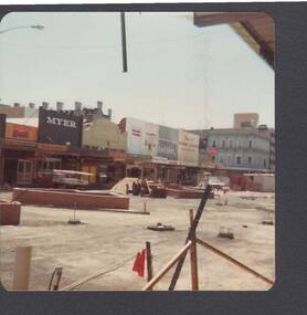 Bendigo Historical Society Inc.
Photograph - BUILDING OF HARGREAVES MALL CANOPIES: MARCH 1982
Coloured photo taken on the 14/3/82 before the construction of the Hargreaves Mall Arches. Myer and Norris Menswear in the background.bendigo, streetscape, hargreaves mall, building of hargreaves mall canopies - march 1982, myer, norris menswear, williams the shoemen, the beehive, thomas jewellers, fosseys, woolworths variety, opsm, coles, ashmans, mccalmans, gillies cnr, commonwealth bank, allans walk -
 The Beechworth Burke Museum
Photograph - Carte de Visite, William E Barnes
In July of 1880, Ann Jones' successful hotel in Glenrowan burnt to the ground during the Kelly siege. She had opened her business in the year prior having been unsuccessful in her attempt to run a tea-room business in Wangaratta. The first building on this particular site was the home Ann Jones had built for herself and her family. Two years later she converted the home and added the hotel to the rear of the structure. One year later it was burnt to the ground. This image depicts the streetscape of Glenrowan in 1883, three years after the siege. Importantly, it reveals the appearance of several buildings which can reveal information for how Glenrowan (as a small town) might have stood during the siege. These buildings are of typical Australian colonial "miner's cottage" style. On what would have been the site of Ann Jones' hotel, to the far left of the photograph, a police station stands. This police station was built before April 1883. This Carte-de-viste (CdV) taken by renowned Wangaratta based photographer William Edward Barnes previously belonged to the donor's grandfather, Daniel Mullins who was a Police Officer stationed at Glenrowan soon after the Kelly gang siege. Today, the siege has become an important part of Australian culture and Ned Kelly and the Kelly Gang (comprising of Ned Kelly, Dan Kelly, Steve Hart and Joe Byrne) has become ingrained in Australian history and mythology. A CdV is a sepia toned photograph mounted on card and is generally of a small size. This particular style was first patented by Andre Adolphe Eugene Disdéri (1819-1889) in 1854. In 1857, the CdV was introduced to England and after photographs of Queen Victoria, Prince Albert and their family were taken using CdV in 1860 the popularity of this method reached a peak.This photograph is part of the Burke Museum "Kelly album" which includes a significant collection of photographs and artefacts connected to Ned Kelly and the Kelly Gang. Ned Kelly and his gang have become ingrained in Australian popular culture and thus many museums, art galleries and private collections house material connected to the Kelly story which allows the events and people to be researched and interpreted. Artefacts and photographs pertaining to the Kelly gang are particularly valuable for Australian museums. This particular photograph is significant for its connection to Wangaratta based photographer William Edward Barnes and to the Glenrowan Siege and Ann Jones' Hotel which burnt down during the siege in June 1880. Taken in 1883, this photograph has the opportunity to provide information about the townscape of Glenrowan shortly after the siege. It also provides important insight into the architecture and layout of the town. To the far right of the image, the photograph depicts the police station which was built on the site of Ann Jones' Hotel which can provide important information for the Kelly story and how the town evolved following 1880. It is also interesting to emphasise that the police station was built on the site of Ned Kelly and the Kelly gang's last stand.This photograph is a sepia image mounted on yellow card which depicts the newly built police station (in 1882) which stands on the far right of the image on the site of the former Ann Jones Hotel. A fence appears through the lower front of the image and an open paddock is to the left. In the rear centre of the image, there is a mountain. In front of the mountain are many trees, most of them gum. The police station is a one storey structure with a veranda and there are three doorways visible in the image. The image depicts four windows on the front of the station.W.E.Barnes / photographer / Wangaratta / ...1882 / BMM8087kelly album, william barnes, wangaratta photographer, carte-de-viste, glenrowan, 1882, police station, ann jones inn, ann jones hotel, kelly siege, glenrowan siege, colonial australia -
 The Beechworth Burke Museum
Photograph - Lantern Slide, c1900
This image shows a semi-aerial view of commercial and official properties lining Ford Street, Beechworth, in approximately 1900. The tower of Christ Church of St Peter and St Paul can be seen in the middle section of the photograph, on the left-hand side of the street. The Church was constructed in 1858 with the tower added to the structure in 1864. Lantern slides, sometimes called 'magic lantern' slides, are glass plates on which an image has been secured for the purpose of projection. Glass slides were etched or hand-painted for this purpose from the Eighteenth Century but the process became more popular and accessible to the public with the development of photographic-emulsion slides used with a 'Magic Lantern' device in the mid-Nineteenth Century. Photographic lantern slides comprise a double-negative emulsion layer (forming a positive image) between thin glass plates that are bound together. A number of processes existed to form and bind the emulsion layer to the base plate, including the albumen, wet plate collodion, gelatine dry plate and woodburytype techniques. Lantern slides and magic lantern technologies are seen as foundational precursors to the development of modern photography and film-making techniques.This glass slide is significant because it provides insight into Beechworth's built environment and commercial and official infrastructure in the early Twentieth Century, around the time of Australia's Federation into one nation. It is also an example of an early photographic and film-making technology in use in regional Victoria in the time period.Thin translucent sheet of glass with a square image printed on the front and framed in a black backing. It is held together by metals strips to secure the edges of the slide.burke museum, beechworth, lantern slide, slide, glass slide, plate, burke museum collection, photograph, monochrome, ford street, christ church of st peter and st paul, church tower, landmarks, 1900, shopping facilities, public buildings, 1900s, built environment, streetscape -
Federation University Historical Collection
Booklet, Wendy Morris, A Guide to Maldon, 1983, 1983
Soft covered booklet featuring an aerial view of the town of Maldon on the cover. heritage, tourism, maldon, mining, streetscape, townscape, gardens, quartz reef mining, geology, maldon goldmines, maldon hospital, kangaroo hotel, architecture, conservation and planning, cast iron, forests, mount tarrangower, nuggetty ranges, beehive -
 Eltham District Historical Society Inc
Photograph, Hurstbridge shops, Heidelberg-Kinglake Road, opposite Hurstbridge Railway Station, Eltham Heritage Tour, 24 May 1992, 24/05/1992
ELTHAM HERITAGE TOUR The Society excursion on 24th May 1992 was arranged by David Bick, leader of the team carrying out the Shire's heritage study. David selected a number of sites or buildings identified in the study, some of them lesser known components of the Shire's heritage. The tour commenced at the Eltham Shire Office at 10.00 am. Travel was by private car and mini-bus with stops at about twelve locations for commentary by David.It included a short walk in Hurstbridge and lunch at Kinglake. Highlights of the tour included: - 10 am Leave from Shire Offices - 3 Important Trees - A Physical Link to Eltham's First Settlers - Toorak Mansion Gates - A Surviving Farm House - An Intact Circa 1900 Main Street - First Settlers - Gold Miners, and Timber-getters - An Early Hotel - A Pioneering Homestead - Changing Eltham Shire - 20th Century - 4 pm Afternoon Tea and Finish Tour Extract from ELTHAM CULTURAL HERITAGE TOUR (Newsletter No. 85, July 1992, by Bettina Woodburn) "Leaving the cars at Hurstbridge we walked the main street of the old village settlement, now a suburb. Near the station was a fine Edwardian house complete with palm and pines. Opposite was the Police Station, 1930-60 with a portable lock-up behind and the residence beside it. No. 794 was the Post Off1ce 3099 the-original shop-front window now has mail-boxes below. Close to the Railway entrance the butcher's shop remains unchanged, but across the road the linear shopping centre tries to keep the character of the olden times. The Fire Bell once hung on a tall gum outside No. 832. Palms in front gardens indicate the age of some of the homes, about 70 years. A corrugated iron shed still stands on the front fence line next to No. 840. Adding to the streetscape is an example of the standard timber early 20th century four veranda post suburban villa."Record of the Society's history and activities and highlighting various aspects of the Heritage Study undertaken by David Bick used to create the future heritage overlay for the Shire of Eltham and later Nillumbik Shire.Roll of 35mm colour negative film, 4 stripsKodak Gold 100 5095shire of eltham historical society, activities, heritage tour, hurstbridge, shops -
Bendigo Historical Society Inc.
Photograph - LA TROBE UNIVERSITY BENDIGO COLLECTION: BENDIGO
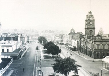
A black and white photograph of the Bendigo Post Office with the flag and the Bendigo Courthouse in April 1969. A man can be seen riding his bicycle in the foreground. Notice the lack of traffic in the street. See 3320.100bendigo, buildings, court house, la trobe university bendigo collection, collection, bendigo, streetscape, pall mall, post office, court house, miss j.c. burnett, mr. geoff pryor, history, building, buildings, place, photo, photos, photograph, photograph -
Bendigo Historical Society Inc.
Photograph - LA TROBE UNIVERSITY BENDIGO COLLECTION: BENDIGO CONSERVATORY
A black and white photograph of the Bendigo Conservatory in April, 1969. Notice the lack of traffic and the earlier model cars. See 3320.100bendigo, parks and gardens, bendigo conservatory, la trobe university bendigo collection, collection, bendigo, building, buildings, gardens, lawn, place, streetscape, history, conservatory, miss j.c. burnett, mr. geoff pryor, photo, photos, photograph, photographs -
 Flagstaff Hill Maritime Museum and Village
Functional object - Copper Sheet, circa 1878
In 1984 the Commonwealth Government made available to Flagstaff Hill a collection of lead ingots and copper sheets recovered from the wreck-site of the LOCH ARD. They were presented to the Warrnambool City Council by the Hon. Tom Uren MHR, Minister for Territories and Local Government: “The Commonwealth recognises that shipwrecks like the LOCH ARD are our national heritage with important educational, recreational and tourist applications” (The Standard, Tuesday 8 May 1984). The LOCH ARD was wrecked in 1878. Unsuccessful salvage operations were then undertaken with the 90 ton paddle steamer NAPIER. In sudden bad weather this vessel too was sunk. The precise position of the LOCH ARD in the exposed and dangerous waters off Mutton Bird Island became lost to memory. The underwater location of the LOCH ARD was rediscovered in 1967 by a Warrnambool skindiver, Stan McPhee. In the two years following his find, the vessel was systematically pillaged by unauthorised salvagers. This led to the State and Federal Governments’ intervention in 1969. A roundup and seizure of recovered lead ingots and copper sheets was conducted by Commonwealth and Victorian Police. Offenders were charged and convicted. The “repossessed loot of the Tassie Boys” was placed into secure storage (Jack Loney, 1978, Wrecks & Reputations). The LOCH ARD manifest of cargo lists “Pig lead 50 tons, 994 pig & 37 rolls” and “Copper 33 plates, 53 bolts”. While the lead ingots have been subsequently described as “ballast”, the copper sheets are unlikely to have been associated with the ship’s normal complement in that way. Similar product lines in the cargo manifest are “Bar and rod iron 102 tons”, “Plate iron 3 tons” and “Zinc 12 tons”. These raw materials were used by colonial artisans such as blacksmiths and metal smelters to fashion, and repair, agricultural implements and industrial machinery. Copper was valued for its non-corrosive properties and its malleability, or ease of working. Both these qualities were useful, for example, in laying underground gas pipes that supplied lighting to residences, businesses and streetscapes in the mid-nineteenth century. As the nineteenth century progressed, the metal was also increasingly valued for its conductivity, with copper wiring linking colonial communities to each other, and the wider world, via the Telegraph system. The average weight of the copper sheets is 216 kilograms, calculated by "volume 0.1936m³ X Cu density 8930kgs/m³".The shipwreck of the Loch Ard is of significance for Victoria and is registered on the Victorian Heritage Register ( S 417). Flagstaff Hill has a varied collection of artefacts from Loch Ard and its collection is significant for being one of the largest accumulation of artefacts from this notable Victorian shipwreck. The collections object is to also give us a snapshot into history so we can interpret the story of this tragic event. The collection is also archaeologically significant as it represents aspects of Victoria's shipping history that allows us to interpret Victoria's social and historical themes of the time. The collections historically significance is that it is associated unfortunately with the worst and best-known shipwreck in Victoria's history. Large heavy sheets or panels of copper metal raised from the wreck of the LOCH ARD. The 10 sheets are of roughly similar dimensions and rectangular shape. They bear signs of prolonged submersion in seawater, with various degrees of limestone accretion, adhered marine growth, and green oxidisation. Three of the sheets are severely buckled, demonstrating the force of underwater explosives used in their salvage. One sheet appears cut or severed in a diagonal line downwards from its top left hand corner. One sheet has a 10cm X 10cm square cut out of its top right hand corner. All sheets are in sturdy, stable condition. No maker’s marks are visible.flagstaff hill, warrnambool, shipwrecked coast, flagstaff hill maritime museum, flagstaff hill maritime village, great ocean road, loch line, loch ard, captain gibbs, eva carmichael, tom pearce, glenample station, mutton bird island, loch ard gorge, sailing ship, copper sheet, manutacturing materials, metal imports, muntz -
 Eltham District Historical Society Inc
Photograph - Digital Photograph, Alan King, St Margaret's Anglican Church, Pitt Street, Eltham, 30 January 2008
St Margaret’s Church of England was officially opened on December 12, 1861. It is the oldest intact church building in Eltham. At the time it was known as Christ Church until its consecration in 1871, when it was completely free of debt (£1,700 for the church and parsonage) despite the district’s poverty. This was largely due to the free labour and materials, including locally made bricks donated by local artisans and others. The church is historically significant because it is the oldest church in the former Shire of Eltham and has associations with the philanthropist and founder of Brighton, Henry Dendy (who donated the land on which the church is built), the architect Nathaniel Billing and the prominent local builder, George Stebbing. The church is architecturally and aesthetically significant because it is constructed in the Gothic Revival style with several stained-glass windows of various dates and is also a very early use of polychromatic brickwork in Victoria. Billing was one of the first Melbourne architects to employ polychromatic brickwork and an important early architect. The rear wall was intended to be temporary. A major feature of the design is the large buttresses with long, steeply graded upper faces. The overall design is well proportioned with the surface brick patterns relieving an otherwise austere design. The church is spiritually and socially significant because it has been an important place of worship for the people of Eltham for almost 150 years. The land on which the buildings stand was donated by Henry Dendy. Dendy arrived in Melbourne in 1841 after purchasing in England eight square miles at Brighton under the system of "special surveys". After this land passed out of his hands, Dendy moved about Victoria, visited England, then returned to settle in Eltham where he purchased a flour mill. Dendy chaired the meeting held in 1860 “for the purpose of devising such means as may be expedient for the establishment of a Church of England in the township of Eltham”. He became chairman and treasurer of the church committee. Unlike the establishment of many early churches in Victoria where a vicar was appointed to a parish and later a permanent church was constructed, the population at Eltham initiated action to build a church. The nearest church at that time was at Heidelberg and the Eltham settlement was part of the parish of St Johns Heidelberg. Isolation and the tedious, time consuming journey between Heidelberg and Eltham resulted in the Eltham community taking its own action. The original vicarage (Dendy House) at the rear of the church is also an important part of the cultural significance of this place because it is connected to the church and the development of the Eltham area. Together, the church and the vicarage are aesthetically significant because they form a significant streetscape feature. The mud-brick community hall designed by Robert Marshall was added in 1978. In 2014 the original temporary rear wall was removed as part of a modern extension designed by Architects Atelier Wagner and constructed by Conrad Construction and Management. Covered under Heritage Overlay, Nillumbik Planning Scheme. National Trust of Australia (Victoria) State significance Victorian Heritage Published: Nillumbik Now and Then / Marguerite Marshall 2008; photographs Alan King with Marguerite Marshall.; p67This collection of almost 130 photos about places and people within the Shire of Nillumbik, an urban and rural municipality in Melbourne's north, contributes to an understanding of the history of the Shire. Published in 2008 immediately prior to the Black Saturday bushfires of February 7, 2009, it documents sites that were impacted, and in some cases destroyed by the fires. It includes photographs taken especially for the publication, creating a unique time capsule representing the Shire in the early 21st century. It remains the most recent comprehenesive publication devoted to the Shire's history connecting local residents to the past. nillumbik now and then (marshall-king) collection, eltham, st margaret's anglican church, st margaret's church, st margarets church hall, christ church -
 Eltham District Historical Society Inc
Photograph - Digital Photograph, Alan King, St Margaret's Anglican Church, Pitt Street, Eltham, 30 January 2008
St Margaret’s Church of England was officially opened on December 12, 1861. It is the oldest intact church building in Eltham. At the time it was known as Christ Church until its consecration in 1871, when it was completely free of debt (£1,700 for the church and parsonage) despite the district’s poverty. This was largely due to the free labour and materials, including locally made bricks donated by local artisans and others. The church is historically significant because it is the oldest church in the former Shire of Eltham and has associations with the philanthropist and founder of Brighton, Henry Dendy (who donated the land on which the church is built), the architect Nathaniel Billing and the prominent local builder, George Stebbing. The church is architecturally and aesthetically significant because it is constructed in the Gothic Revival style with several stained-glass windows of various dates and is also a very early use of polychromatic brickwork in Victoria. Billing was one of the first Melbourne architects to employ polychromatic brickwork and an important early architect. The rear wall was intended to be temporary. A major feature of the design is the large buttresses with long, steeply graded upper faces. The overall design is well proportioned with the surface brick patterns relieving an otherwise austere design. The church is spiritually and socially significant because it has been an important place of worship for the people of Eltham for almost 150 years. The land on which the buildings stand was donated by Henry Dendy. Dendy arrived in Melbourne in 1841 after purchasing in England eight square miles at Brighton under the system of "special surveys". After this land passed out of his hands, Dendy moved about Victoria, visited England, then returned to settle in Eltham where he purchased a flour mill. Dendy chaired the meeting held in 1860 “for the purpose of devising such means as may be expedient for the establishment of a Church of England in the township of Eltham”. He became chairman and treasurer of the church committee. Unlike the establishment of many early churches in Victoria where a vicar was appointed to a parish and later a permanent church was constructed, the population at Eltham initiated action to build a church. The nearest church at that time was at Heidelberg and the Eltham settlement was part of the parish of St Johns Heidelberg. Isolation and the tedious, time consuming journey between Heidelberg and Eltham resulted in the Eltham community taking its own action. The original vicarage (Dendy House) at the rear of the church is also an important part of the cultural significance of this place because it is connected to the church and the development of the Eltham area. Together, the church and the vicarage are aesthetically significant because they form a significant streetscape feature. The mud-brick community hall designed by Robert Marshall was added in 1978. In 2014 the original temporary rear wall was removed as part of a modern extension designed by Architects Atelier Wagner and constructed by Conrad Construction and Management. Covered under Heritage Overlay, Nillumbik Planning Scheme. National Trust of Australia (Victoria) State significance Victorian Heritage Published: Nillumbik Now and Then / Marguerite Marshall 2008; photographs Alan King with Marguerite Marshall.; p67This collection of almost 130 photos about places and people within the Shire of Nillumbik, an urban and rural municipality in Melbourne's north, contributes to an understanding of the history of the Shire. Published in 2008 immediately prior to the Black Saturday bushfires of February 7, 2009, it documents sites that were impacted, and in some cases destroyed by the fires. It includes photographs taken especially for the publication, creating a unique time capsule representing the Shire in the early 21st century. It remains the most recent comprehenesive publication devoted to the Shire's history connecting local residents to the past. nillumbik now and then (marshall-king) collection, eltham, st margaret's anglican church, st margaret's church, christ church -
 Eltham District Historical Society Inc
Film - Video (VHS), Phil Burke et al, Shire of Eltham Grants Commsission Submission (Series 69, Item 7), 1993
Shire of Eltham Archives: Series 69, Item 7 Opens with aerial views of the Shire, 85% of the shire covered by the Green wedge principal. Discusses the obligations required of the Shire to maintain the Green Wedge. The Shire covers over 27,000 hectares with a population in excess of 45,000 residents, more than 70% living in the southern 10% of the Shire in suburbs of Eltham, Montmorency, Lower Plenty and Research. 85% of the Shire in the more sparsely populated northern area which is covered by the Green Wedge. Council is committed to providing a parity of services to all residents such as garbage collection and maintenance of roads. Views of rubbish collection trucks in Montmorency. It is emphasised that the cost of these services in highly populated areas is relatively low whereas in the sparsely populated Green Wedge areas, considerable. There are hundreds of kilometres of roads throughout the Shire, many unmade and maintenance is high to check overhanging trees and erosion especially on the steep hills is expensive and disproportionate to servicing the population in the dense urban areas. Shows views of hilly gravel roads and graders at work maintaining them. Shows scenes of assessing planning applications in these rural areas which takes significantly more time as well as other services provided such as Meals on Wheels, building permits, Ranger services. Provision of recreational facilities in hilly areas requires the acquisition of expensive river flats (views of cricket ground surrounded by hills) and where not possible, costly earthmoving required. Also, views highlighting extensive tracks of natural habitat home to significant bird, animal and plant life. Shire emphasises its commitment highlighted by the Eltham Copper Butterfly which the Shire maintains small pockets of bushland to ensure its survival at significant expense (views of Pauline Toner Copper Butterfly Reserve.) Short interview with Pat Vaughan, Environmental Officer for the Shire discussing the Eltham Copper Butterfly who also mentions many other species in the Shire of high significance from bats to mammals to plants as well as the importance of the Green Wedge to Melbourne – the lungs of Melbourne - and ensuring the protection of very important habitat which requires a great deal of planning and management to look after. Views of Wingrove Park to emphasise this maintenance by machinery in some areas is too damaging and introduced species, etc must be removed by hand. Balancing the services and facilities expected by the community with the needs of the environment requires careful planning demands requires careful planning and the principals of the Green Wedge require constant attention in the face of growing need for housing. Director of Planning & Environment, Richard Allen advises there are approximately 1,300 planning permits and development applications each year ranging from simple subdivision, boundary realignments to further complicated non-urban developments for agricultural pursuits and the level of expertise required from architectural and engineering to land degradation, flora and fauna. Video finishes with aerial views and parklands, streetscapes and rural areas. VHS Video cassette Converted to MP4 file format 00:07:39; 89MBshire of eltham, video recording, shire of eltham archives, eltham shire council, eltham, building permits, cricket ground, development applications, eltham copper butterfly, garbage collection, graders, green wedge, lower plenty, meals on wheels, montmorency, pat vaughan, pauline toner reserve, planning applications, planning permits, ranger services, recreational facilities, research, richard allen, roads, rural areas, wingrove park, victoria grants commission