Showing 112744 items
matching tracks/roads
-
 City of Kingston
Pamphlet - Colour, Stillwell and Co, The Hill Estate, Highett, 1917
Sales plan for land in the suburb of Highett, bounded by Point Nepean Road and including Sandford Street, Turner Road, Alfred Street and Peace Street.The developing urban area of Highett within the City of Kingston. This land sale pamphlet illustrates the subdivision of land within the municipality and the changing demographic of the district as new houses are constructed close to infrastructure.Colour pamphlet advertising for sale at auction The Hill Estate, Highett. Incorporates a map of the estate bordered by Point Nepean Road and including Sandford Street, Turner Road, Alfred Street and Peace Street.Handwritten in grey pencil on subdivision map next to subdivisions 91, 92, 93, 106, 107 and 108: x Handwritten in grey pencil on back cover: The / Hill Estate / Highettland sales, estate, highett -
 Mt Dandenong & District Historical Society Inc.
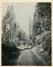
Photograph, Jeeves Coach on CRB Road at Foot of Farringdon Road Kalorama, 1920, 1920
Scene looking down Farringdon Road showing Jeeves horse drawn coach going along the CRB road (Mt Dandenong Tourist Road) in 1920. Detailed inscription on the back handwritten by John Lundy-Clarke in 1974.Jeeves Coach on CRB road at foot of Farringdon Road Kalorama (Mt Dandenong North) 1920. Road was formed most of the length from Montrose by contractors Bladin and Dick employing Robert Logan the younger, in 1919 and lay unmetalled till metalled by the contractors in 1922. Mountain ash trees in foreground were on Thomas Hand’s original 23 acre holding. Those beyond coach were on Isaac Jeeves original 160 acre holding Selection Crown Allotment 925(B). This was the area forming part of the inheritance lost by John William Richardson because of the expense of his wife’s illness. Hand enlarged his 23 acres to 305 in 1874. William and his family grew large crops of raspberries on his area, part of which is in the foreground. It had been cleared by his father’s employees before 1877. The section below the Main Road was cultivated by Fred hand, son of William and grandson of Thomas in the twenties before he moved to Redcliffes where he is today (1974). Comment by John Lundy-Clarke 10.5.1974 coach service, jeeves, crb road, farringdon road, kalorama, mt dandenong north, mt dandenong tourist road, john lundy-clarke, coach -
 Ringwood and District Historical Society
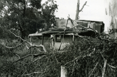
Photograph-B&W, Wantirna Road Shack next to Dandenong Creek on East Side of Wantirna Road (near the bridge), 6/07/1989
Wantirna Road Shack next to Dandenong Creek on East Side of Wantirna Road (near the bridge). Has been there many years - maybe 40 and it is still there (18.9.1989). (Note this is NOT part of Hill's dairy but was in the same series of photographs so kept together).A shack next to Dandenong Creek / East side of Wantirna Road / Has been there many years - maybe 40 / It is still there (18.9.89) -
 Glen Eira Historical Society
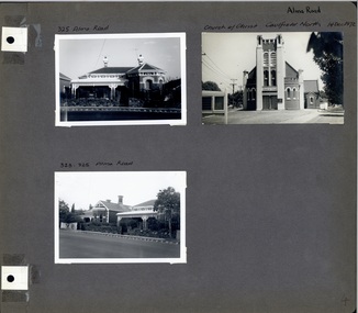
Album - Album page, Alma Road, circa 1972
This photograph is part of the Caulfield Historical Album 1972. This album was created in approximately 1972 as part of a project by the Caulfield Historical Society to assist in identifying buildings worthy of preservation. The album is related to a Survey the Caulfield Historical Society developed in collaboration with the National Trust of Australia (Victoria) and Caulfield City Council to identify historic buildings within the City of Caulfield that warranted the protection of a National Trust Classification. Principal photographer thought to be Trevor Hart, member of Caulfield Historical Society. Most photographs were taken between 1966-1972 with a small number of photographs being older and from unknown sources. All photographs are black and white except where stated, with 386 photographs over 198 pages. Church of Christ, 514 Dandenong Rd, Caulfield https://vhd.heritagecouncil.vic.gov.au/places/43594 The Dandenong Road Church of Christ has regional importance as a landmark building along the Dandenong Road. It successfully addresses its triangular site by placing the belltower at the apex, deploying Romanesque and Gothic elements freely and to dramatic effect, heightened by the symbolism of the Cross (compare Robert Haddon's St Stephens in Balaclava Road of 1926).Page 4 of Photograph Album including three black and white photographs of properties on Alma Road. Two photographs are in the top half of the page and the third is in the bottom left hand side.Handwritten in black pen: Alma Road [top right of page] / 325 Alma Road [above top left photograph] / Church of Christ Caulfield North 14 Dec 1972 [above top right photograph] / 323-325 Alma Road [above bottom left photograph] / 4 [bottom right]caulfield north, trevor hart, alma road, houses, churches, church of christ caulfield north, dandenong road, bell towers, romanesque architectural style, gothic architectural style, bi-chromatic brickwork, cast iron work, verandahs, victorian architectural style -
 City of Kingston
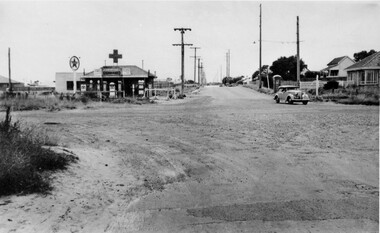
Photograph - Black and white, c. 1950
... Roads ...The intersection of Warrigal Road and Nepean Highway is now a major intersection, serviced by traffic lights. In the 1950s it was a joining of two sealed roads, although covered in gravel, and with wide gravel shoulders. There are no traffic signs and the few houses visible are not set very far back from the road. This image is one of many in the collections that focuses on either roads or the railway. The development of roads and the railway was crucial to the ongoing development of the area.Black and white photograph of the intersection of Warrigal Road and Nepean Highway, Mentone. Handwritten in blue ink on reverse: 218 Handwritten in red ink on reverse: 75%mentone, roads, suburbs -
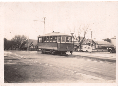 Ballarat Tramway Museum
Photograph - Geelong Scrubber Moorabool Street at McKillop St, Wal Jack, July 1950
Photo of the Geelong scrubber on a wide road, single track in Moorabool St at McKillop St - Note the pole with the single track bracket arm. See item 7844 for the negative. Dated July 1950.Yields information about the use of the Geelong Scrubber or water tram.Black and white photograph, with hand written details on rear.See rear image. tramways, trams, geelong, scrubber tram -
 Kiewa Valley Historical Society
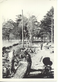
Black and White photograph of Road Making Machinery, Kiewa Road Making 25/8/1938(No. 3 in a series of 8), 25/08/1938
Construction of the main road from South Tawonga to the Bogong High Plains, to provide access to the construction sites for the new Kiewa Hydro Electric Scheme, was commenced early in 1938, the work being undertaken on behalf of the Commission by the Country Roads Board. For the construction work, the Commission purchased three Caterpillar - model R07 - diesel crawler tractors equipped with Kay Brunerei (Brunner) hydraulically operated trail builders (angle dozers)). This acquisition resulted from a visit to the United States of America in May, 1937 by the Construction Engineer ( Mr. C.H. Kernot) and Assistant Civil Engineer (Mr. J.F. Douglas) where they saw this relatively new type of equipment in use. With the co-operation of the CRB, the Commission demonstrated the operation of these machines at Fishermen's Bend on 6th April, 1938. They were then sent to Kiewa where they commenced operation towards the end of the month. From South Tawonga, the route led immediately across the Western Branch of the Kiewa River necessitating the construction of a bridge 100 feet long. By the end of 1939,the excavation had been 'opened up' for a distance of 19 1/2 miles (approx. 31 km.) and of this length, 10 miles (approx. 16 km) had been surfaced.The purchase and use of this type of mechanical equipment in road making was a huge investment, as prior to this most of the work would have been done manually with the use of picks and shovels. Not only were many months of hard manual labour saved, but a very significant amount of time in providing access to the proposed work sites for the new Kiewa Hydro Scheme. This photo is an excellent reminder of how primitive the early machinery was compared to the present but also represents the forward thinking of the State Electricity Commission's Engineers in purchasing such new and innovative equipment.A black and white photograph of a Caterpillar diesel crawler tractor and a hydraulically operated trailbuilder (angle dozer) making a road in the Mt. Beauty area.Hand written in black ink in the top left hand corner are the words "Kiewa Road Making 25/8/1938". On the upper right hand of the photograph has been stamped the number 3. On the back is stamped the word 'Velox' severaly times, which is the make of the photograhic paper. roadmaking, caterpillar tractor, kiewa, state electricity commission -
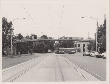 Melbourne Tram Museum
Photograph - Black & White Photograph/s, The Met, mid 1980's
Black and White photograph of the new footbridge over Swanston Street at Elgin Street, mid 1980's, with sw6 class No. 931 in The Met colour scheme turning into Elgin street on route 1, East Coburg. Shows the track at this location, prior to its extensive redevelopment as a terminus. The footbridge, serves Melbourne University. A take-away shop is on the corner.On the rear in ink "Newly erected Road bridge, Swanston St North @ Melb Uni"trams, tramways, swanston st, elgin st, melbourne university, tram 931, sw6 class, the met -
 Melbourne Tram Museum
Slide, John Webster, 19/04/1960 12:00:00 AM
Colour slide, Kodak, white cardboard of the Hawthorn Tram depot from Wallen Road looking into the depot fan and sheds. Has a man in white jacket sweeping? the track. Shows the stairs to the first floor.Hand writing on rear in ink "19-4-60, Depots, Hawthorn Tram Depot"trams, tramways, hawthorn depot, wallen rd -
 Melbourne Tram Museum
Photograph - Digital Image, Public Transport Victoria (PTV), "Buses replace trams - route 58", Oct. 2020
Digital Image of a pamphlet "Buses replace trams - route 58", November and December 2020 for the reconstruction of the tram track through Royal Park. Has details on the bus replacement services, map and road closures.trams, tramways, royal park, trackwork, track -
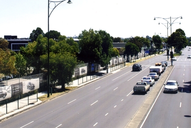
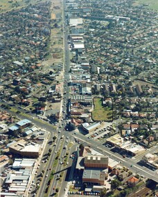 City of Kingston
Photograph - Colour, c. 1982
... Roads ...This aerial photograph of South Road and Nepean Highway, Moorabbin shows the area where houses and shops on the south side of the Nepean Highway have demolished for the widening of the highway. The pressures of rapid urban development in Moorabbin and beyond, especially to the south of Moorabbin caused bottlenecks and delays, especially at the South Road and Nepean Highway intersection, hence the scheme to widen Nepean Highway.The pressures of rapid urban development in terms of people, housing construction, industrial development and commercial activity, in Moorabbin and beyond, especially to the south would put pressure on road infrastructure in the region. In the early 1980s, a major road expansion of the Nepean Highway was implemented to increase capacity on this major thoroughfare for vehicle commuters. Car use had also increased with commuters from the increasingly populous southern suburbs travelling to their place of work in the Melbourne CBD.Colour photograph of an aerial view of South Road and Nepean Highway, Moorabbin. The image shows houses on the south side of the Nepean Highway that have demolished for widening of road. It features housing and commercial buildings looking north towards Cummins Road.Handwritten blue ink: 82 - 5452 - 11 Handwritten red ink: 112% Handwritten black ink: Ch. 7nepean highway, south road, moorabbin, roads, transport, infrastructure -
 Orbost & District Historical Society
black and white photograph, late 19th - early 20th century
This photograph was taken at the junction of the Snowy and Brodribb Rivers. The Snowy River starts in New South Wales on the slopes of Mt Kosciuszko, Australia’s highest mountain, in New South Wales. It flows into Bass Strait at Marlo in Victoria. The Brodribb River is a tributary of the Snowy which enters the estuary at Marlo. This is a pictorial record of a road in Marlo near Orbost in the late 19th-early 20th centuries. It also depicts the transport used at that time.A black / white photograph of four men in suits seated in a horse - drawn buggy on a dirt road alongside a creek or river. There appears to be another horse - drawn vehicle behind them.on back - "at the Brodribb - Snowy junction. this road was corduroy (packed logs of tea trees?)brodribb-river snowy-river marlo transport-horse-drawn -
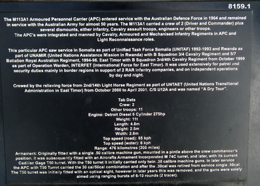 Bendigo Military Museum
Equipment - ARMOURED PERSONNEL CARRIER, Unknown
This item is on display in the gardens of the Bendigo District RSL Sub Branch Havilah Road. Refer photo .1) re details of manufacture, history and use..1) Plaque metal black on a stand with details re the item. .2) Armoured Personnel Carrier M113A1 (APC) painted in camouflage colours with markings, tracked vehicle.“134233”brsl, smirsl, bdrslinc, apc, carrier -
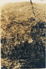 Halls Gap & Grampians Historical Society
Photograph, C 1920s
This is a photo of the Mt. Victory Road under construction. The workers camp can be seen in front of the road. For further information see 'Victoria's Wonderland', pp 102, 112 & 136. Note: The second copy is a transparency held at Slide Box No. 162.The photo shows a slope covered in thick bush. A road can just be seen in the middle foreground and a campsite with many tents can be seen through the bush in front of the road.access routes, mt victory rd -
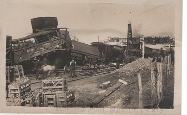 Hume City Civic Collection
Photograph, 17th April 1919
On 17th April 1919 a stock train travelling north crashed head-on with a goods train coming in the opposite direction. The driver thought he had been given the all-clear to proceed into Sunbury and it was only when the train was approaching the Macedon Street bridge that he saw the red light and it was too late. The accident caused damage to rolling stack and disruption on the Bendigo and Maryborough lines. The train coming from Bendigo smashed onto the platform at Sunbury. The driver of the stock train was thrown under the van and suffered a broken arm and facial injuries. The fireman was thrown clear of the tracks. A local Sunbury doctor treated them before they were taken by a casualty train to hospital. A crew from Melbourne came to Sunbury to repair the damage. The track was cleared by that afternoon.This rail crash is one of a number that have happened in and near Sunbury over the years.A black and white photograph with a cream border, of a goods train smash at a railway siding. The carriages have 'jack-knifed'. Four men are on the tracks looking at the damage while a number of onlookers are surveying the damage from a footbridge. There are boxes of rabbit carcasses in crates stacked in the foreground.rail crashes, sunbury -
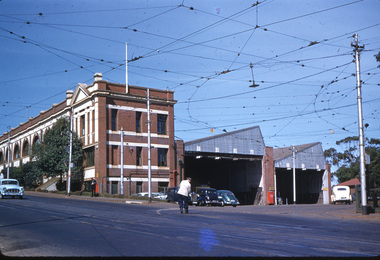
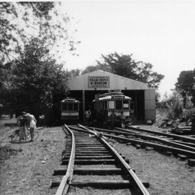
 Ballarat Tramway Museum
Photograph - Black & White Photograph/s - set of 2, post June 1973
Yields information about the construction of the track and depot fan c 1972.Black and white photographs of the construction of the access track and depot fan at the new BTPS depot, involving he carting of gravel etc in wheel barrows. The poles have been positioned and the track extended over the level crossing indicating 1973, prior to the installation of one road. See - 1972 - 73 Annual Report page 3 for a list of dates.trams, tramways, depot, btps, construction -
 Phillip Island and District Historical Society Inc.
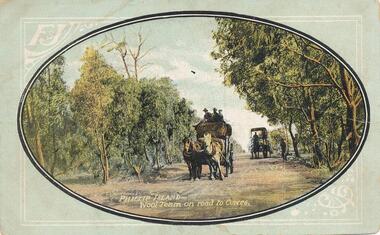
Photograph - Post Card, F & J Postcards, 1900's
Donated by S Serpell of Serpell & Reid Families, SandringhamColoured Postcard of two horse drawn coaches. Three people on the coach in the foreground and one person on the rear coach. A person on the roadside. Trees either side of the road. Front: Phillip Island - Wool Team on road to Cowes. Back: Harbison's Wool & Dray.wool team, horse drawn wagons, horse drawn coaches, s serpell -
 Hawthorn Historical Society
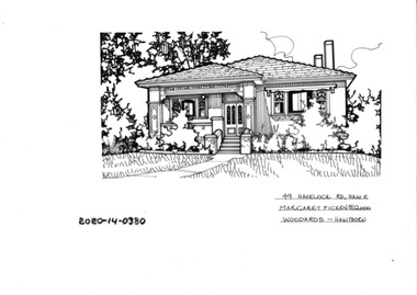
Drawing - Property Illustration, 49 Havelock Road, Hawthorn East
'After training as a Cartographic Draftsman within the mining industry, I worked as a property illustrator for real estate firms in the eastern suburbs of Melbourne for 23 years from 1983. I initially photographed houses with a Polaroid camera and made a 'thumbnail' sketch while there. The photos were used to scale off a sketch in pencil and then that sketch was overlaid with drafting film and the 'pen and ink' completed. The pens I used were the Rotring ‘Rapidigraph’ drafting pens. The ink was also made by Rotring (German).The film was ‘Rapidraw’, polyester drafting film, double matte. It takes a very fine line and doesn’t bleed. As well as house sketches, there were often floor plans and site plans ordered. Aerial sketches were ordered when the property needed an overall view.' (Margaret Picken, 2020)This property illustration is one of a series created by Margaret Picken for a range of real estate agents in Melbourne between c. 1983 and c. 2006. Each work is signed and dated by the artist.Gift of Margaret Picken, 2020pen and ink architectural drawing on drafting film. Dimension 255x165 Inscription: 49 HAVELOCK ROAD, HAW E Margaret Picken ©2000 WOODARDS -C'WELL49 HAVELOCK ROAD, HAW E Margaret Picken ©2000 WOODARDS -C'WELLartist - margaret picken 1950- -
 Phillip Island and District Historical Society Inc.
Photograph, 1900's
This postcard is contained in an album presented to the then Governor of Victoria, The Earl of Stradbroke, by the fathers of soldiers & returned soldiers of Phillip Island, on 16/02/1923. The history of the album is noted on Reg. No 85-00Postcard of Beach Road, Cowes, showing stable on site of Continental Hotel, where horse and drags collected passengers to take to Summerland, early 1900's. Moreton Bay Fig planted by Von Mueller.The Rose Series P674. Beach Road Cowes, Phillip Island, Victorialocal history, photography, photographs, slides, film, beach road, cowes, phillip island, the esplanade, transport, moreton bay fig, sepia photograph, beach road cowes -
 Mt Dandenong & District Historical Society Inc.
Photograph, c1911
"Hillcrest" on Mernda Road, Olinda. The home of the Devine Family. c1911 The descriptive text on the reverse of this photograph was hand written by John Lundy-Clarke.“Hillcrest” Mernda Road Olinda 1911. The home of the Devine family. The early settlement road passed to the left of the camera. House faced down over the valley of the Sassafras + Perrin Creek towards Kallista. The deviation to regrade the road passed to the right of the house. It was in front of the house on the left hand side of the picture that Vera Devine and her school mates practiced the maypole dance under her tuition. hillcrest, devine, devine family, mernda road -
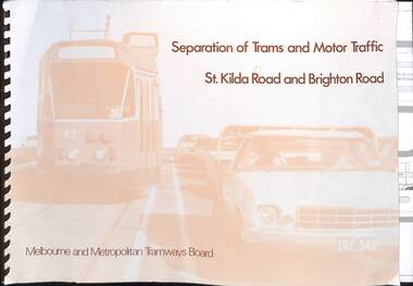 Melbourne Tram Museum
Document, Melbourne & Metropolitan Tramways Board (MMTB), "Separation of Trams and Motor Traffic - St Kilda Road and Brighton Road", May 1979
Document prepared to provide the concepts for separation of traffic along St Kilda Road and Brighton Road using safety bars, and reserved sections of roadway between Princes Bridge and Glen Huntly Road. Dated May 1979. Has an introduction, and notes the widening of St Kilda Road south of Cochrane St and its impact. Has colour photo of Z89 in Nicholson St where the Safety bars had been installed to separate traffic, installation of Safety Zones, photos of Gothenburg, Amsterdam, and Hanover showing traffic separation, graphs showing tram passenger movement in the am peak and road usage. Looks extensively at the Domain Interchange at Park and Domain Road and the suggested layout - which was implemented in Nov. 1986. Includes a photo of a very long line of trams northbound at this intersection which has undergone many changes location, to become during 2025 the entry to Anzac station. Six drawings show the proposed separation of traffic between Alexandra Ave and Glen Huntly RoadDemonstrates a planning document to separate road traffic from trams along St Kilda Road.Comb bound document titled "Separation of Trams and Motor Traffic - St Kilda Road and Brighton Road" - 12 sheets + card covers, some full colour pages with some sheets folded.tramways, st kilda road, traffic control, domain interchange, domain road, reserved track -
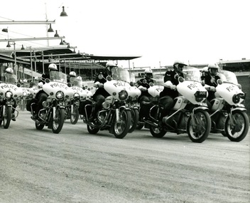 Victoria Police Museum
Photograph (police motorcycle)
Hondas and BMWs in exhibition formation at a showgrounds or trotting track. There are grandstands in the background and lights over the track. Circa 1973Noel Duffy, Terry Walsh, Ian Taylorpolice vehicles; motor transport branch; motor transport section; motor cycle patrol; police motorcycles; honda motorcycle; bmw motorcycle -
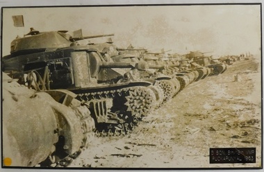 8th/13th Victorian Mounted Rifles Regimental Collection
Photograph - Grant tanks
B Squadron of 8/13 Victorian Mounted Rifles was based on Wangaratta-Benalla. The 8th/13th Victorian Mounted Rifles was raised as a regiment of the Royal Australian Armoured Corps on 1 May 1948 with Headquarters in Melbourne and squadrons in Sale, Benalla/Wangaratta and Albury. In 1955 Regimental Headquarters moved to Wangaratta and a second squadron was located at Albury. The Sale squadron transferred to 4th/19th Prince of Wales’s Light Horse. In 1977 8/13 VMR Regiment was reduced to an independent squadron A Squadron 8th/13th Victorian Mounted Rifles and in 1991 was linked with 4th/19th Prince of Wales’s Light Horse forming the VMR Squadron of that regiment.Black and white photograph of General Grant tanks lined up track-to-track at Puckapunyal, mounted on chipboard backing.B. Squadron, 8/13th Victorian Mounted Rifles Puckapunyal 1953military, grant, tank, benalla, wangaratta, vmr -
 Ballarat Tramway Museum
Photograph - Black & White Photograph/s, Jack Chadwick, March or April 1973
Yields information the construction of the depot fan by the BTPS and the various stages of the work and the trams at the time.Black and white photograph of the depot fan from extension of three road, March - April 1973 - track work complete for crossover, 3 road extension, but the poles and troughing yet to be started. Photographed on an open day. Jack Chadwick photograph. See - 1972-73 Annual Report - list of dates."Jack Chadwick" in ink on the rear.trams, tramways, depot construction, btps, trackwork -
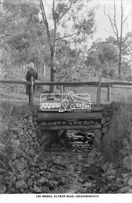 Eltham District Historical Society Inc
Photograph, The Rose Stereograph Company, Log Bridge, Eltham Road. Greensborough, c.1920
A woman stands at the end of a log bridge over a creek looking towards the south along the unsealed roadway. The sun illuminates her back. She is wearing a woollen knit beanie with edges rolled up, dark jacket and skirt, full length dark stockings and slip on dark leather shoes with raised heel, typical of the early 1920s. The creek is possibly feeding into the Karingal Yalloc. The direction of the road based on shadows is northwest as is the Eltham Road to Greensborough (present day Sherbourne, Karingal and St Helena roads). The creek is falling to the foreground so from south west to the north east, possibly feeding into the Karingal Yalloc, somewhere near presenet day Ramptons Road Reserve. This glass plate negative was used to manufacture postcards (1:1 printing) for commercial sale by the Rose Sterograph Company and its subsidiaries. George Rose founded the Rose Stereograph Company in 1880 and was joined by Herbert (Bert) Cutts in the early 20th Century. The pair formed a lifetime working partnership and strong personal friendship. Assisted by George’s two sons, Herbert George and Walter, and later by Neil Cutts, the Rose Stereograph Company continued its operations for more than 140 years. The company was initially built on stereographs, but as cinema took over and stereographs fell out of fashion, the Rose Stereograph Company developed Australia’s first commercially viable photographic postcard business. Specialising in postcards of iconic historical moments and significant landmarks, The Rose Stereograph Company became a staple of the Australian travel industry.This remarkable collection of glass plate negatives, transparencies, and postcards – arguably Australia’s most significant photography collection outside of public hands – has been passed down through the generations, surviving war, relocation, and the harsh Victorian climate. The historic Rose Stereograph collection is the culmination of George Rose’s dream of capturing and preserving precious moments in time and remains the legacy of the Rose and Cutts families. It is with great sadness that the Cutts family says goodbye to a collection that spans five generations and 140 years. The Cutts family understands that for these historically important pieces to rest with one family is to deny others the pleasure of their custodianship.Glass Plate Negative Size: 9.2 x 13.8 cmLog Bridge, Eltham Road, Greensborougheltham, postcard, travel, rose stereograph company, glass plate negative, creek, eltham road, greensborough, karingal road, karingal yallock, log bridge, sherbourne road, st helena road, women's fashion, rampton's road reserve, peter and elizabeth pidgeon collection -
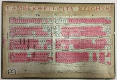 Kew Historical Society Inc
Plan - Subdivision Plan, Jas R Mathers Son & McMillan, Camberwell City Heights, 1922
"Following the 1919 amalgamation of suburban tramway trusts, an electrified tram service extended along Doncaster Road. Housing estates such as the 1919 Balwyn Park Estate, 1922 Hillcrest Estate and the Camberwell City Heights Estate, also 1922, quickly followed. These estates were built over by expansive suburban villas, set in fine gardens and along tree-lined streets. North Balwyn, largely constructed since 1933, was typified by even grander houses, many of them in the 'ocean liner' style and seen at their most distinctive in the Riverview Estate." (Source; 'Balwyn' in eMelbourne)Portions of subdivision plan mounted on both sides of cardboard sheet. Coloured pink, probably to show allotments sold. Area covered: Doncaster Road, Mountainview Road, Panoramic Road, Cityview Road, Longview Road, Riverview Road, Hillview Road, Bulleen Road. Includes location diagram showing railway lines and existing and proposed tram routes.Cardboard backing has advertisement for "Tillock's soluble coffee"subdivision plans -- camberwell (vic.), camberwell city heights subdivision -
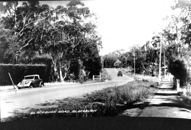 Whitehorse Historical Society Inc.
Photograph, Blackburn Road, Blackburn
black and white photo of Blackburn Road, Blackburn.2 copies of black and white photo of Blackburn Road, Blackburn.blackburn road, 1930s - 1940s ? -
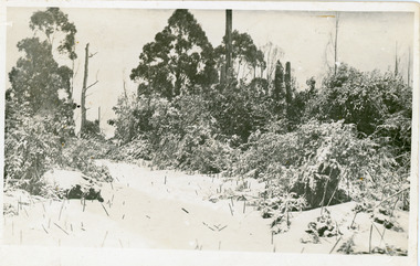 Mt Dandenong & District Historical Society Inc.
Photograph, Snowfall At Chalet Road, 1921
Postcard made for E. Woorich "Range View" Olinda showing Chalet Road in Olinda under snow in 1921.Printed on back in purple ink: E. Woorich "Range View" Olinda Handwritten in pen: 1921 snowfall at Chalet Road.range view nursery, e. woolrich, chalet road, snow, olinda -
 Kiewa Valley Historical Society
Black and White photograph of Road Making Machinery, Kiewa Road Making, 25/08/1938
Construction of the main road from South Tawonga to the Bogong High Plains, to provide access to the construction sites for the new Kiewa Hydro Electric Scheme, was commenced early in 1938, the work being undertaken on behalf of the Commission by the Country Roads Board. For the construction work, the Commission purchased three Caterpillar - model R07 - diesel crawler tractors equipped with Kay Brunerei (Brunner) hydraulically operated trailbuilders (angle dozers). This acquisition resulted from a visit to the United States of America in May, 1937 by the Construction Engineer ( Mr. C.H. Kernot) and Assistant Civil Engineer (Mr. J.F. Douglas) where they saw this relatively new type of equipment in use. With the co-operation of the CRB, the Commission demonstrated the operation of these machines at Fishermen's Bend on 6th April, 1938. They were then sent to Kiewa where they commenced operation towards the end of the month. From South Tawonga, the route led immediately across the Western Branch of the Kiewa River necessitating the construction of a bridge 100 feet long. By the end of 1939, the excavation had been 'opened up' for a distance of 19 1/2 miles (approx. 31 km) and of this length, 10 miles (approx. 16 km) had been surfaced.The purchase and use of this type of mechanical equipment in road making was a huge investment, as prior to this most of the work would have been done manually with the use of picks and shovels. Not only were many months of hard manual labour saved, but a very significant amount of time in providing access to the proposed work sites for the new Kiewa Hydro Scheme. This photo is an excellent reminder of how primitive the early machinery was compared to the present but also represents the forward thinking of the State Electricity Commissions engineers in purchasing such innovative equipment . A black and white photograph showing the type of machinery used for road making in the 1930's. It shows a grader being towed by a caterpillar tractor.On the top left hand corner of the photograph , hand written in black ink is the words 'Kiewa Road Making 25/8/1938'. On the right hand side of the photo has been stamped in blue the Number 1. It has been developed on Velox paper (marked on back of photo) with a gloss finish.road making, state electricity commission, caterpillar tractor, kiewa -
 Whitehorse Historical Society Inc.
Photograph, Whitehorse Road, Blackburn, 2012
... roads ...The property on the left of Whitehorse Road was once the Cottees factory. It later became the Leader Newspaper headquarters. It was next owned by Lexus Motor Sales and is now used (2014) as a storage yard with the eastern end used by Leader Newspaper as a staff car park.Coloured photograph of Whitehorse Road, Blackburn - 2012. Cars waiting to turn right into Surrey Road.whitehorse road, blackburn, roads