Showing 3161 items
matching bridge street
-
 Ballarat Tramway Museum
Document - Photocopy, Neville Gower, " Mayor's Report 1972-1973", Jul. 1997
... covering roads and bridges and reconstruction of streets following... in the Ballarat Library. One page covering roads and bridges ...Photocopy of part of City of Ballaarat's Mayor's Report for 1972- 1973. Originals held in the Ballarat Library. One page covering roads and bridges and reconstruction of streets following removal of trams. Includes photos of part of Wendouree parade at View Point. Image added 18-12-2016trams, tramways, city of ballaarat, trams, railways, civic history -
 Bendigo Historical Society Inc.
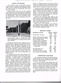
Document - LONG GULLY HISTORY GROUP COLLECTION: INVITATION TO BOOK LAUNCH
... is in the bottom corner. One page has a small photo of a street and bridge... is in the bottom corner. One page has a small photo of a street and bridge ...Two invitations to the Launch of the Book 'A Brief History & Reminiscence of Long Gully' by George Ellis to be Launched by Laurie Whelan, Mayor of the City of Greater Bendigo. A photo of the Ironbark Mine with the Manchester Arms Hotel in the background is in the bottom corner. One page has a small photo of a street and bridge railing.bendigo, history, long gully history group, the long gully history group - invitation to book launch, st matthews church hall, a brief history & reminiscence of long gully, george ellis, laurie whelan, city fo greater bendigo, ironbark mine, manchester arms hotel -
 Greensborough Historical Society
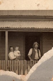
Photograph - Digital image, George Stock and family 1909, 1909_
... and son George, George William Stock. House in Main Street near... in Main Street near bridge over river. Photographs from ...George Stock and family 1909 (left to right) Jane Finn and son George, George William Stock. House in Main Street near bridge over river. Photographs from the collection of Peter Blackbourn, a descendant of the Chapman Stock family. Annotations to photos by Peter Blackbourn.Digital copy of black and white photograph.peter blackbourn, george willam stock, jane stock (nee finn), george stock -
 Ballarat Tramway Museum
Photograph - Black & White Photograph/s, State Electricity Commission of Victoria (SECV), late 1950's or early 1960
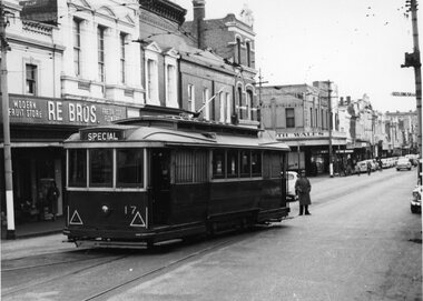
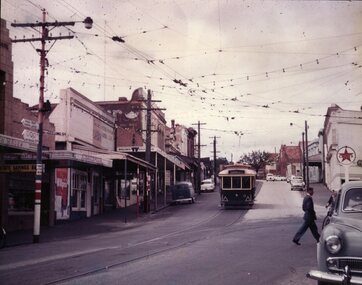
... at Stone Corner, intersection of Bridge and Main Streets Ballarat... Corner, intersection of Bridge and Main Streets Ballarat ...Yields information Bridge Street and the buildings at the junction with Main and Victoria St / Stones corner. Tram parked for some particular reason - see 3802 and 3803 for a similar set of photographs. Shows shops and cars.Set of three Black and White photographs, of No. 17 at Stone Corner, intersection of Bridge and Main Streets Ballarat. The tram is parked in a number of slightly different positions with the same gent in an overcoat behind the tram - reason unknown. See also Reg Item 3802 and 3803 for a two similar photographs but without the gent. Possibility of an accident investigation. In the background are RE BROS fruit shop, Bank of New South Wales and Lancashires. tramways, trams, bridge st, stones corner, tram 17 -
 Kew Historical Society Inc
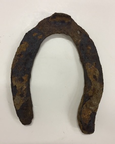
Functional object, City of Kew, Rusted Horse Shoe, Horse Tramways Shed, Kew, 1887-1950
... . The horse tram (1887-1914) ran from the Victoria Street Bridge...-1914) ran from the Victoria Street Bridge to the entrance ...The site on the north side of High Street, Kew, on the corner of Disraeli Street is now the location of the Kew Recreation Centre. The current (as of 2020) swimming pool was formerly situated further west on the site but was relocated closer to Disraeli Street during the 1980s. Previously, this was the site of a Kew Council depot, and before that a horse tram shed. The horse tram (1887-1914) ran from the Victoria Street Bridge to the entrance of the Boroondara General Cemetery. Rusted horse shoe, excavated from the site of the Kew Recreation Centre on the corner of High and Disraeli Streets in Kew. The shoe was donated by Mr Poulter, City Engineer, City of Kew. The shoe may have been made for one of the horses that pulled the Kew Horse Tram or one of the Council depot horses.horse tram - kew (vic), archaeological items - kew (vic), horse shoes, kew recreation centre, council depots - kew (vic), tram sheds - kew (vic) -
 Ballarat Tramway Museum
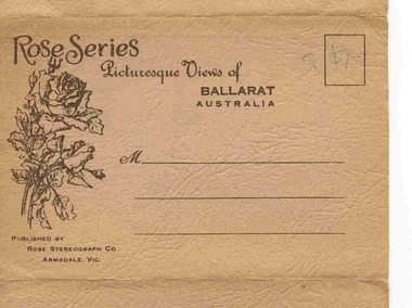
Postcard - Folder set, Rose Stereograph Co, "Rose Series Picturesque Views of Ballarat Australia", c1940
... 8. "Bridge Street" - showing an SEC single truck tram... 8. "Bridge Street" - showing an SEC single truck tram ...Set of 12 views of Ballarat printed with six photos on either side of a folded strip of paper contained within a heavy brown paper folder. Published by the Rose Stereograph Co. of Armadale Vic., titled "Rose Series Picturesque Views of Ballarat Australia". Front cover has address area, stamp position, a drawing of roses and publishers details. 1. "The Town Hall and Sturt St. " with two trams eastbound in Sturt St. The first tram is a Sebastopol type tramcar. (see image 4) 2. "Eureka Memorial" 3. "The Conservatory" 4. "The gardens and Town Hall, Sturt Street" 5. "Panorama of " Sturt St. from Town hall, looking east 6. "Avenue of Honour Arch" 7. "The Flight from Pompeii - The Gardens" statue 8. "Bridge Street" - showing an SEC single truck tram in the street (see image 5) 9. "The Statuary Pavilion, Botanical Gardens" 10. "Sturt St." 11. "Lake Wendouree" 12. "Sturt St." (from Grenville St.) - with two ESCo trams in photograph (see image 6) (See also Reg. Item 2268 for a single postcard using this image.) All have words "Ballarat Vic." after the caption. Images 1 of front cover, 2 and 3 are of the object itself. Date of photos seem to be varied over time from early 1930's through to 1940's given the different motor cars in the photographs. On front cover in pencil in stamp area "G $7-"trams, tramways, ballarat, rose postcards, sturt st, bridge st, gardens, esco -
 Port Melbourne Historical & Preservation Society
Poster, History of a Street Precinct
... History of a Street Precinct, documenting 80 years plus... Melbourne Town Hall 333 Bay Street Port Melbourne melbourne ...A cultural grant was given to Margaret BRIDE to implement this study, which she did with the help of her husband Graham and several residents of the study area including PMH&PS members Emily LOCK, David THOMPSON, Jack BOLT and Kerrie MATHEE.History of a Street Precinct, documenting 80 years plus of the history of the area bounded by Williamstown Road and Evans, Bridge and Farrell Streets, since 1880. One of two products of a 2005 project (which subsequently won the 2007 Victorian Local History Award for research). A brochure containing a map of the area and photos and information on key properties. An interactive CD (2148.02) containing information and photographs on 91 buildings and their occupants over time was also produced. built environment -
Port Melbourne Historical & Preservation Society
Mixed media, History of a Street Precinct
... History of a Street Precinct, documenting 80 years plus... Melbourne Town Hall 333 Bay Street Port Melbourne melbourne ...A cultural grant was given to Margaret BRIDE to implement this study, which she did with the help of her husband Graham and several residents of the study area including PMH&PS members Emily LOCK, David THOMPSON, Jack BOLT and Kerrie MATHEE.History of a Street Precinct, documenting 80 years plus of the history of the area bounded by Williamstown Road and Evans, Bridge and Farrell Streets, since 1880. One of two products of a 2005 project (which subsequently won the 2007 Victorian Local History Awards for research). An interactive CD containing information and photographs. This was packaged with a brochure (2148.01) containing a map of the area and photos and information on key properties and individuals on 91 buildings and their occupants over time.built environment -
 Kew Historical Society Inc
Photograph - Burgess House, Victoria Street (Abbotsford), 1880-1900
... and the Victoria Street Bridge. Photo shows three men and one woman working... between Burnley Street and the Victoria Street Bridge. Photo shows ...Major floods recurred of the Yarra River on a regular basis. A flood in 1901 destroyed this house in Victoria Street, Abbotsford. Later print copy of an original photograph. Home of C/N Burgess on the south side of Yarra River. The buildings were washed away in a flood in 1901 The house was in the same location as that on which Handley & Tilly was later built. This would locate it on the north side of Victoria Street, Abbotsford between Burnley Street and the Victoria Street Bridge. Photo shows three men and one woman working in an established garden in front of a weatherboard cottage."Home of C/N Burgess on south side of river; washed away in 1901; Handley & Tilly on site"yarra river -- floods, yarra river flood -- 1901, burgess family -- victoria street -- abbotsford (vic.) -
Port Melbourne Historical & Preservation Society
Archive - Bayside Development, Resident Action Group, Pat Grainger Archive, 1987 - 1992
... , Clarendon Street Bridge Light Raillink Advisory Committee..... 1989 - 1994, Clarendon Street Bridge Light Raillink Advisory ...These papers document Pat Grainger's involvement with the many facets of campaigning against the Sandridge City Development Company Bayside Project. Files & indexed by J Bolitho.Pat Grainger Archive - Bayside Development, Resident Action Group - Public Action Campaigner. Archival box containing audio tape & tape log. Individual manilla folders for the following years & subjects; 1987, Organisational submissions to ESS Sept 1987-Feb 1988, personal file retained from ESS Sept 1987 - Feb 1988. 1988, Friends of the Park 1988 - 1999. 1989 - 1994, Clarendon Street Bridge Light Raillink Advisory Committee.public action campaigns, local government - city of port melbourne, town planning - proposals shelved - bayside, melbourne harbor trust - port of melbourne authority, pat grainger -
 Bendigo Historical Society Inc.
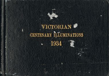
Photograph - VICTORIAN CENTENARY ILLUMINATIONS 1934
... of Yarra, Princes Bridge, Collins Street, Flinders Street... Inc. History House 11 Mackenzie Street Bendigo goldfields ...Photo album, brown hard cover, writing in gold leaf ' Victorian Centenary Illuminations 1934' Contains black and white images of Melbourne, taken at night. Includes, south bank of Yarra, Princes Bridge, Collins Street, Flinders Street, Elizabeth Street, Shrine of Remembrance, St. Kilda, Swanston Street, Hawthorn War Memorial, State Electricity Commission Head Office, Electricity supply Building, Electricity Commission and Port Authority buildings, South Melbourne Town hall, Hotel Windsor, Parliament House, Town hall, Fire Brigade building, State Savings Bank, National Bank, Melbourne town hall, Bank of Australia, Port Authority Building, Steam Tower. All the photographs in this album pertain to the City of Melbourne, and have NOT been scanned.cottage, miners, melbourne, melbourne, centenary -
Bendigo Historical Society Inc.
Newspaper - NEWSPAPER COLLECTION: BENDIGO ADVERTISER VARIOUS ARTICLES
... Equipment 21) Built on the Foundations of Gold 22) Photos: Bridge... on the Foundations of Gold 22) Photos: Bridge Street - Oakley's Establishment ...1) Bendigo the Golden Heart of Victoria 2) News from Bendigo May, 1973 3) Some Scenes of Bendigo Yesteryear 4) Cover Bendigo Advertiser Souvenir of the Shamrock Hotel 5) Saving the Shamrock - Doug McClure 6) Farewell Bendigo's Trams April, 1972 7) 100 Years of Trams 8) Gold Mine a Popular Attraction 9) Tomorrow the end (Trams) April 1972 10) Trams 1890-1903-1972/ Photo New Chum 11) Vintage Talking Trams 12) In Search of a Home for Sun Loong 13) Bendigo Dragon City 14) History Indicates that Dragons is not as Silly 15) Bendigo's Dragon is Something to be Proud of 16) Unravelling the Dragon's Mysteries 17) Reputation Precede it 18) Tourism 19) Haunted by the Ghosts of the Gold Rush 20) Bendigo Undertaking Firm Installs Complete Motor Funeral Equipment 21) Built on the Foundations of Gold 22) Photos: Bridge Street - Oakley's Establishment 23) A City Built on reefs of Fabulous Wealth 24) Bendigo Company Has High Hopes for Old Mine 25) The Central Deborah 26) Central Deborah Reaches New Depths 27) WMC Prepares the Way for Bendigo Mining Revival 28) Historical Background of Fortuna 29) Opening of TAFE College 30) 60 Protesting Nurses Greet the Premier 31) A History Written in Bricks 32) The Golden Age of Bendigo Theatre Part 1 33) The Golden Age of Bendigo Theatre Part 2 34) J.H. Curnow is Back Home 35) Fortuna Historical Background 36) Photos of Fortuna. Folder 110 now in Box 417. AV 03/11/2022 -
 Eltham District Historical Society Inc
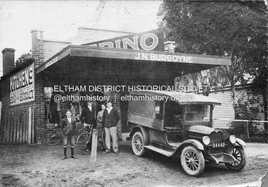
Negative - Photograph, J.N. Burgoyne’s store, Main Road, Eltham, Vic, c.1930
... truck. The store was located on Main Road just south of Bridge... truck. The store was located on Main Road just south of Bridge ...The photo is of John Neville and Ethel (Polly) Burgoyne’s store with eldest children and a 1927/28 model Chevrolet 1 ton truck. The store was located on Main Road just south of Bridge Street (present day No. 820 Main Road). L-R (unconfirmed): Francis (Frank) Neville Burgoyne (1916-2002), unidentified, Mary Frances Burgoyne (1914-1991) and John (Jack) William Burgoyne (1913-2005) which would date the picture as circa 1929/1930. Henry Charles Burgoyne (1920-1994) and Royston (Roy) Edward Burgoyne (1922-2004) not in picture. The unidentified male is believed to be an early boyfriend of Mary Frances at the time, not Reginald John Squire (1916-1981) whom she married in 1938 who was two years her junior. The new store was built in late 1925. At the same time Mr C. Nicholls’s new store was constructed. Both were considered modern shops, and an improvement on most, business establishments of the time. Mr. Nicholls’s store included alongside it a modern, weatherboard villa residence. Mr. Burgoyne’s store incorporated the post and telegraph office, which was operated by John Neville Burgoyne’s half-aunt, Miss Anne Hunniford. The unsealed footpath in front is reasonably extensive as not visible is a concrete kerb and channel which was laid from the Post Office to John Street during Nov-Dec 1926. Footpath construction in front of Burgoyne’s store commenced August 1942. An extension to the store was erected in 1939 for a new telephone exchange adjacent to the store and post office. A continuous telephone service operated by Mr Burgoyne and his family commenced operation 18 November 1939. Approximately 70 extensions were routed through the new exchange, 40 of which were transferred from the Greensborough Exchange. Reproduced on p92 of 'Pioneers & Painters' Cross Ref: 0702 shows extension on right of shopThis photo forms part of a collection of photographs gathered by the Shire of Eltham for their centenary project book,"Pioneers and Painters: 100 years of the Shire of Eltham" by Alan Marshall (1971). The collection of over 500 images is held in partnership between Eltham District Historical Society and Yarra Plenty Regional Library (Eltham Library) and is now formally known as the 'The Shire of Eltham Pioneers Photograph Collection.' It is significant in being the first community sourced collection representing the places and people of the Shire's first one hundred years.Digital image 4 x 5 inch B&W Negshire of eltham pioneers photograph collection, 1927 chevrolet series aa truck, burgoyne's shop, eltham, francis (frank) neville burgoyne (1916-2002), frank burgoyne, henry charles burgoyne (1920-1994), jack burgoyne, john (jack) william burgoyne (1913-2005), john neville burgoyne, main road, mary frances burgoyne squire (1914-1991), pioneers and painters, post office, shops -
 Ballarat Tramway Museum
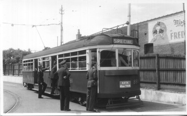
Photograph - Colour Photograph/s, Jim Seletto, c1960
... of dash Canopy lighting, c1960, at the intersection of Bridge..., at the intersection of Bridge and Main Streets. Tram No. 11 is arriving from ...Colour Photograph of SEC tram No. 11, prior to fitting of dash Canopy lighting, c1960, at the intersection of Bridge and Main Streets. Tram No. 11 is arriving from Victoria St. and is about to cross the junction with the Mt. Pleasant line. Trams stops are visible on poles, as is the overhead arrangement, shops on both sides. Tram has large reflective triangles on cab front. Caltex service station sign on right side of photograph. On pole with tram stop sign is a sign with the Olympic rings, pointing way to Lake Wendouree.ballarat, bridge st, victoria st, olympics, tram 11 -
 Ballarat Tramway Museum
Photograph - Black & White Photograph/s, State Electricity Commission of Victoria (SECV), late 1950's or early 1960
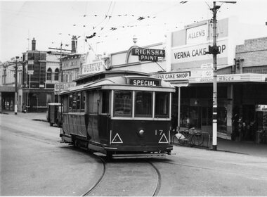
... , intersection of Bridge and Main Streets Ballarat. Parked just past... Parade Ballarat Ballarat goldfields Yields information Bridge ...Yields information Bridge Street and the buildings at the junction with Main and Victoria St / Stones corner. Tram parked for some particular reason - see 3807.1 to .3 for a similar set of photographs. Shows shops and cars.Black and White photograph, No. 17 at Stone Corner, intersection of Bridge and Main Streets Ballarat. Parked just past the junction points - reason unknown, see also Reg Item 3803, 3807.1 to 3807.3 - for other photographs of the tram at the same location. Photo late 1950's or early 1960. Also has a number of interesting motor vehicles in the background. In the background a Ricksha Paints (pronounced Rickshaw), Allen's Vernal Cake Shop, Junction Shoes. Roddas, ANZ and the English Scottish Bank of Australia buildings in the view. tramways, trams, bridge st, stones corner, tram 17 -
 Kew Historical Society Inc
Photograph - The Boulevard at Kew, 1937
... Asylum; and 1936 when the road from the Johnston Street Bridge... Asylum; and 1936 when the road from the Johnston Street Bridge ...The Yarra Scenic Boulevard stretching from Hawthorn to the Chandler Highway was completed as a major project between 1933 and 1936 during a period of significant unemployment. Key dates in the construction this section the road include: 1933 when Kew Council supported the construction of the road from Studley Park to the Kew Asylum; and 1936 when the road from the Johnston Street Bridge to the Chandler Highway was opened. The inscription on the reverse of the photo 'Boulevard Fairfield' is misleading as there is no section of the Boulevard in Fairfield. A more likely interpretation is that it is a photograph of the Kew section of the Yarra Boulevard with the factories of Fairfield in the distance.Rare early photograph of the Yarra Boulevard, taken one year after the opening of the road. The photograph is an important historical record of the results of 'Susso' labor in the creation of major works in Melbourne by the Victorian Government. Original, black and white positive print of the Boulevard at Kew in 1937. Key aspects to note about the photograph is that the road is bituminised; that the gutters are concreted; that the kerb is constructed of concrete blocks; and that there is an unmade footpath on what appears to be the right hand side of the road. The landscape is sparsely treed, and those trees that remain are presumably remnant vegetation. At the right, the land is fenced. The land at the left falls away sharply to the river below. On the horizon, at left, there is an industrial complex including a tall chimney that is burning fuel creating smoke. "Boulevard Fairfield" great depression, susso projects, roads -- kew (vic.), yarra boulevard, yarra valley -
 Eltham District Historical Society Inc
Journal - Newsletter, Newsletter, No. 261 December 2021, Dec 2021
... Street Bridge by Peter Pidgeon • Eltham Cemetery Stories... Street Bridge by Peter Pidgeon • Eltham Cemetery Stories ...Contents: • Well …. Things have been somewhat different …. Again! by Jim Connor • A Christmas Tale by Richard Pinn • First Open Air Gallery in Australia (part 2) by Liz Pidgeon • The Mercury by Jim Connor • The Wilsons and the Kinloch Barn (part 2) by Michael Wilson with Liz Pidgeon • Eltham Insights (part 2) by Pam Robinson • Annual General Meeting – 24th November 2021 • Brougham Street Bridge by Peter Pidgeon • Eltham Cemetery Stories by Richard Pinn o Robert David Taylor • Contacts for the Eltham District Historical Society The Shire of Eltham Historical Society was formed in October 1967. The first newsletter of the Society was issued May 1978 and has been published continuously ever since on a bi-monthly basis. With the cessation of the Shire of Eltham in late 1994, the Society's name was revised to Eltham District Historical Society and this name first appeared with issue No. 103, July 1995. The collection of the Society's newsletters provides a valuable resource on the history of the Society's activities, office bearers and committee members, guest speakers and subjects of historical interest pertinent to the former Shire of Eltham and the Eltham District.A4 newsletter distributed to members (Digital and A4 photocopy)newsletter, eltham district historical society, covid-19, coronavirus pandemic -
 Eltham District Historical Society Inc
Photograph, Eltham Festival Parade, 16 October 1982, 1982
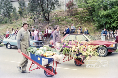
... Bridge Street. Floats included the Tasmanian Wilderness Society... Bridge Street. Floats included the Tasmanian Wilderness Society ...Roll of negatives of the Eltham Festival Parade as it progresses along Main Road past the Catholic Church heading towards Bridge Street. Floats included the Tasmanian Wilderness Society with the Save the Franklin River campaign, and Diamond Valley Railway celebrating 21 years of passenger service as well as the Victorian Police Marching Band. A well known Eltham identity, Jock Read was asked to lead the Eltham Pony Club contingent that year and the roll includes several shots of Jock on his horse, Lofty who was approximately ten years of age, his colour was still classed as a steel grey at the time before he went "white" quite a few years later. 1982: 16-17 October. “Pioneers of Eltham” and tractor (rain) Neswletter No. 27, November 1982 Although our parade entry did not win a prize this year, it was considered highly successful from a participation point of view. Despite some uncertainty as to just who was coming, members and friends kept appearing at the assembly area. As in the past years our friends from the Victorian Folk Music Club brought their instruments along and really added to the occasion. This year we concentrated on a rural theme with a tractor/trailer combination. Thanks to Peter Bassett-Smith for the tractor, Joh Ebeli for the decorations and friendly trailer owner Dennis McKay. Unfortunately the closing stages of the parade were marred by heavy rain. We just finished as the rain started but members scattered very quickly. This has prompted the suggestion for future parades that we have a tent or other suitable venue for members to gather after the event. This is worth following up. The cold driving rain provided a special problem for Peter in driving his tractor home to Kangaroo Ground. Have you ever had to choose between standing up to warm your hands on the exhaust and having your tractor seat flooded? Certificate, Festival Parade Award, Rotary Club of Eltham, Eighth Eltham Community Festival 1982. Presented to the Shire of Eltham Historical Society for the most effort by "locals"Roll of 35mm colour negative film, 24 shotsKodak Safety Film 5035eltham festival, catholic church, diamond valley railway, eltham, eltham district historical society, eltham parade, festivals, eltham fire brigade, eltham horse and pony club, jock read, learning co-op primary school, eltham living and learning centre, lofty (horse), main road, marching band, montmorency scouts, parade, parade floats, peter bassett-smith, research pre-school, roller city, shire of eltham historical society, victorian police -
 Federation University Historical Collection
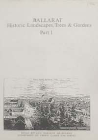
Book, Peter Lumley et al, Ballarat: Historic Landscapes, Trees & Gardens, 1983, 1983
... plantings, Russell, Victoria, Bridge Mall, Sturt Street Gardens... Victoria Street plantings Bridge Mall Plantings george longley 275 ...Lisa Green and Lisa Morcom of Ballarat College of Advanced Educatiion contributed to this report.275 page landscape study of Ballarat including Trees in the Victorian Landscape; Plant sources early Ballarat nurseries, Botanical Gardens, Lake Wendouree, Fairy Gardens, Victoria Park, Ballaarat Old Cemetery, Eastern Oval, City Oval, Ballarat East Town Hall Gardens, Eureka Stockade, Observatory, Yarrowee, Black Hill, Sovereign Hill, Cheek Channels, Canadian Creek, Poverty Point Reserve, Goldmining Relics, Woah Hawp, Buninyong, street plantings, Russell, Victoria, Bridge Mall, Sturt Street Gardens, Avenue of Honour, Webster, Elms, ballarat, trees, nursery, r.u. nicholls, francis moss, ballarat botanical gardens, victoria park, lake wendouree, ballaarat old cemetery, eastern oval, ballarat east town hall gardens, ballarat school of mines botanical gardens, eureka stckade recreation reserve, ballarat observatory, yarrowee creek, black hill reserve, sovereign hill, ballarat avenue of honour, victoria street plantings, bridge mall plantings, george longley -
 Flagstaff Hill Maritime Museum and Village
Document - Navigation Chart, Admiralty Office, Lady Bay and Warrnambool Harbour, 1893
... , bridges and the streets in Warrnambool. It has sounding details...), streets, roads, bridges and many buildings. It also shows the lay ...This navigation cart of Lady Bay and Warrnambool Harbour was originally surveyed in 1870 but this version includes the update for magnetic variation in 1893. Since the printing of the chart several annotations have been added. These include an additional stamp dated 15-8-1910, a handwritten comment across the top of the page dated August 1910, and another handwritten comment regarding the ‘Proposed Extension of Dock’ dated 19-2-1925, plus connected drawings, notes and figures. The 1925 proposal on this chart may have been a reaction to the Royal Commission of 1923, when the damaged stonework on the seaward side of the Warrnambool Breakwater, caused by the action of the sea, was the subject of enquiry. A conference between the Public Works, Water Commission and the Harbour Trust concluded that it would less costly to make repairs to prevent further damage rather than replaced the damage portion of the wall. A contract was raised in late 1924 to deposit rubble on the damaged side of the breakwater to minimise the Southern Ocean’s destructive action and work had started by August 1925. The Breakwater construction had begun in 1874 and was completed in 1890. The Victorian Government had commissioned Sir John Coode, a British harbour engineer, to present a plan to complete the Warrnambool Breakwater but his original plan was too expensive. He prepared a revised plan for a shorter structure. The construction proved to be too short to protect adequately from the weather and didn't allow enough depth for larger vessels to come into port. The decreasing trade was further affected by siltation in the bay due to the breakwater, and the completion of the railway line. The situation of the harbour became a real problem by 1910 and required continuous dredging. In 1914 the Breakwater was extended but proved to be a failure because the work began to subside and by 1920 about two thirds of the harbour was silted up. Alterations made in the 1920's increased the silting problem and by the 1940's the harbour was no longer used. More alterations were made in the 1950's and 1960's. This chart is significant for its strong connection to the maritime history of Warrnambool Harbour and Lady Bay and the Warrnambool Breakwater. The Warrnambool Breakwater is registered as a place of significance on the Victorian Heritage Database (VHR H2024). The Warrnambool Breakwater is one of the most important late 19th century maritime engineering projects in Victoria and significant in the development of Victorian coastal shipping. It is also significant for its connection with British harbour engineer, Sir John Coode. The chart is a historical record of structures existing in 1893; the Warrnambool Jetties, Warrnambool Breakwater in Lady Bay, the leading lights (lighthouses), streets, roads, bridges and many buildings. It also shows the lay of the land and seabed. Navigation Chart: Lady Bay and Warrnambool Harbour, Australia - South Coast - Victoria. Surveyed by Nav. Lieut. H.J. Stanley, R.N., 1870. Updated for Magnetic Variation, 1893. The rectangular chart is printed on heavy cream paper. Stamps are shaped rectangular, oval and round. Around the Breakwater and Jetty area are handwritten notes, dotted and joined lines, numbers and signatures, and shading of red and green. The chart shows the surrounds of Warrnambool Harbour, Lady Bay, the Breakwater and Jetty, roads, bridges and the streets in Warrnambool. It has sounding details, and angles of line from the leading lights.Stamp, rectangular, including "AUG 1910" Stamp, double oval " - - - -CHART" Stamp, hand drawn, red circle, with "B" inside Hand written note "22-8-1910 - - - - - of surveying C. Ca - - - request of 15-8-10 [initials] " Notes and lines in red pen, including a grid of sounding numbers: "1300" "1050" "1200" "Possible Extension of Dock" "19-2-25" "Dock Dredged to 20 Ft" Notes and lines in blue pen "Extension of Dock to accommodate vessels drawing 20 Feet" and "Light not visible south of this line" Red dots (4) with yellow highlight at both leading lights, breakwater and jettyflagstaff hill, warrnambool, flagstaff hill maritime museum & village, maritime museum, maritime village, shipwreck coast, map, chart, navigation chart, plan, lady bay, warrnambool harbour, port of warrnambool, breakwater, jetty, pier, dock extension, proposed extension, vhr h2024, 1870, 1893, 1910, 1925, warrnambool town late 1800s, warrnambool streets late 1800s royal commission, 1923, public works, water commission, harbour trust, victorian harbours, sir jon coode -
 Ballarat Tramway Museum
Photograph - Black & White Photograph/s, State Electricity Commission of Victoria (SECV), late 1950's or early 1960
... , intersection of Bridge and Main Streets Ballarat. Parked just past... of Bridge and Main Streets Ballarat. Parked just past the junction ...Yields information Bridge Street and the buildings at the junction with Main and Victoria St / Stones corner. Tram parked for some particular reason - see 3807.1 to .3 for a similar set of photographs. Shows shops and cars.Black and White photograph, No. 17 at Stone Corner, intersection of Bridge and Main Streets Ballarat. Parked just past the junction points - reason unknown, see also Reg Item 3802, 3807.1 to 3807.3 - for other photographs of the tram at the same location. Photo late 1950's or early 1960. In the background a Ricksha Paints (pronounced Rickshaw), Allen's Verna Cake Shop, Junction Shoes. Roddas, ANZ and the English Scottish Bank of Australia buildings in the view. Also the signal for incoming trams from Main St, on the post with the tram stop. tramways, trams, bridge st, signals, stones corner, tram 17 -
 Kew Historical Society Inc
Plan, J R Mathers & McMillan, 5 Splendid vVlla Allotments,: Segtoune St. & Windsor St., Kew, 1928
... Street via Bridge Road and Flinders Street. Opposite the East Kew... Street via Bridge Road and Flinders Street. Opposite the East Kew ...Prue Sanderson, in her groundbreaking ‘City of Kew Urban Conservation Study : Volume 2 - Development History’ (1988), summarised the periods of urban development and subdivisions of land in Kew. The periods that she identified included 1845-1880, 1880-1893, 1893-1921, 1921-1933, 1933-1943, and Post-War Development. These periods were selected as they represented periods of rapid growth or decline in urban development. An obvious starting point for Sanderson’s groupings involved population growth and the associated economic cycles. These cycles also highlighted urban expansion onto land that was predominantly rural, although in other cases it represented the decline and breakup of large estates. A number of the plans in the Kew Historical Society’s collection can also be found in other collections, such as those of the State Library of Victoria and the Boroondara Library Service. A number are however unique to the collection.Subdivision plans are historically important documents used as evidence of the growth of suburbs in Australia. They frequently provide information about when the land was sold on which a built structure was subsequently constructed as well as evidence relating to surveyors and real estate and financial agents. The numerous subdivision plans in the Kew Historical Society's collection represent working documents, ranging from the initial sketches made in planning a subdivision to printed plans on which auctioneers or agents listed the prices for which individual lots were sold. In a number of cases, the reverse of a subdivision plan in the collection includes a photograph of a house that was also for sale by the agent. These photographs provide significant heritage information relating house design and decoration, fencing and household gardens.In 1928, five residential allotments bordering Segtoune and Windsor Streets were advertised for sale as part of a subdivision. Four of the blocks faced Segtoune Avenue. The auctioneers proclaimed the advantages of the sites: ‘Situate one minute from the High Street Electric Tram, which now runs direct to Spencer Street via Bridge Road and Flinders Street. Opposite the East Kew Railway Station (Outer Circle Line), which may be reopened In connection with the new Line from Kew to Doncaster; Adjacent lo the Kew Recreation Reserve, Sports Oval, and Swimming Bath; Half Minute from the Shopping Centre of East Kew, Accessible to the State School and Other Educational Centres’. The Harp of Erin Hotel and the route of the Outer Circle Railway line are marked on the plan. The Recreation Reserve and Sport Oval refer to Victoria Park. The Swimming Baths were located on the site of the current Kew Recreation Centre.subdivision plans - kew, segtoune street -- kew (vic.), windsor street -- kew (vic.) -
 Eltham District Historical Society Inc
Slide - Photograph, Eltham Town Park, c.May 1988
... , Panther Place, Main Road, Bridge Street, and Susan Street..., Panther Place, Main Road, Bridge Street, and Susan Street ...In 1981 the Shire of Eltham Historical Society was asked by the Victorian Place Names Committee to comment on a proposal by the Shire of Eltham to assign names to parklands in Eltham as follows:- "Eltham Common" - the area between the municipal offices, Main Road, the Eltham railway -line, and Panther Place and containing Shillinglaw Cottage. The Shire has advised that this name has been used locally for the site since about 1975. "Alistair Knox Park" - the area bounded by the Eltham railway -line, Panther Place, Main Road, Bridge Street, and Susan Street, and through which flows the Diamond Creek. The area has been known locally as "Eltham Town Park" The proposed name "Alistair Knox Park" had created some local controversy with a number of reversals of the Council's decision and letters to the local paper both for and against the proposal. The society was reluctant to be drawn into this controversy particularly as there were known to be members with strong views both for and against the proposed name. The society appreciated the work done by Alistair Knox both in the formulation of the park concept and in its development but because of the controversy generated by the proposed naming and also because of the wide general use of the park by the public·, the name Eltham Town Park was felt more appropriate. The society noted that there was no outstanding historical associations with the land comprising the park which would warrant naming the park after any particular person, place or event. No objection was raised to the Eltham Common proposal as set-out above. The decision was made in the knowledge that Alistair Knox had been associated with the society over many years and was a prominent figure in the recent history of Eltham. He was regarded as a key figure in the environmental building movement and in particular was renowned for his use of mud bricks as a building material. He served as a councillor of the Shire of Eltham from 1971-1975, his final year as Shire President. It was during these years that the proposals to create the park in its present form were shaped and Alistair played a leading part in the decision to make it a landscaped passive recreational park rather than a sporting area. The parklands comprise a section of the Diamond Creek valley. The creek itself flows through the centre of the area which is overlooked by steep hills on each side. The parks form part of the land purchased from the Crown in 1851 by J.M. Holloway and then subdivided into allotments and called "Little Eltham". While most of the area was subdivided into residential lots the creek valley was subdivided into lots suitable for small farms. Some further subdivision took place over the years and the whole of the parks now comprises eight separate titles. A list of some of the former owners has been compiled but exhaustive research on all owners has not been carried out. The ownership of one parcel has been traced back to when it was purchased from Holloway by John Hicks Petty in 1874, long after it was subdivided. Other families owning land within the area over the years included Lyon, Rees, Clark, Waterfall, Carrucan, Graham, Hill and Morant. The character of the valley area has remained rural while development occurred on each side. Early photos show the area as orchard and grazing land. In 1901 the railway was constructed through the area resulting in the timber trestle bridge across the Diamond Creek. which is an important feature of the park landscape. A memorial obelisk to the Eltham servicemen killed in World War 1 was erected at the south eastern corner of the park. The site is now within the intersection of Main Road and Bridge Street and the memorial was shifted in the 1950s to the Eltham R.S.L. clubrooms. Following the financial failure of the local sub-branch, the memorial obelisk was again relocated to the Eltham War Memorial building precinct in 2011. During the early 1960's the Council started purchasing the land which now comprises the parks. In the late 1960's the area to the east of the Diamond Creek was used as a garbage tip and filled above the flood plain of the creek. When this area was filled the tip was transferred to the west side of the creek. From the early 1970's the area has been progressively developed as a park for passive recreation with ornamental lakes, extensive tree planting and landscaping. The character of the valley before the days of the tip has been recreated and this has earned a Landscape classification from the National Trust, an unusual honour for a man-made landscape. The parks are not only attractive in appearance. The large number of people using them, particularly at weekends and holidays is evidence of their popularity and the foresight and careful planning of local residents, Councillors and Council Staff. 35mm colour positive transparency (1 of 23) Mount - Kodak EktachromeProcess Date MAY 88Meltham, main road, alistair knox park, eltham town park -
 Federation University Historical Collection
Book, Ballarat Illustrated : Under the Seals of the City & Town Councils, c1920
... . Red Shop Tea Rooms . Tyler's - Bridge Street, Ballarat... - Bridge Street, Ballarat . Allchin Bros Ballarat . Loreto Abbey ...This book was a donation to Federation University Australia's Professor David Battersby from Vice-Chancellor Professor Scott Bowman of Central Queensland University.Soft cover. Front cover with some red. 80 pages. Back cover Plan of Ballarat Map. Photographic plates. Brief history of Ballarat and the topics photographed. . Ballarat City Municipal Chambers . The Ballarat Banking Company Limited . Art Gallery Ballarat . The Ballarat Trustees, Executors & Agency Company Limited . John MacLeod & Coy Pty Ltd . The Ballaarat Gas Coy . Ballarat's Homes . J. J. Goller & Co. . Ballarat East Views . Star Office . The Ballarat Courier . Morshead's . M. B. John Ballarat - The largest Inland Brass Foundry in Australia . Rowlands Koomah Spa . Huttons the Jewellers . Botanical Gardens Ballarat . Millers the Clothiers . Jas Smith Agricultural Machinery . Views of Lakes Learmonth & Burrumbeet . Coles & Pullum Stock & Station Agents . Harry Davies & Co. . Views about the City . Benoit's Sun Foundry . Ballarat College (for Boys) . Wm Paterson's . Lydiard Street Views . Eureka Terra-cotta & Tile Co. of Australia Limited . Churches of Ballarat . The Ballarat Woollen & Worsted Co. Ltd Sunnyside Mills . Red Shop Tea Rooms . Tyler's - Bridge Street, Ballarat . Allchin Bros Ballarat . Loreto Abbey Mary's Mount Ballarat . Brinds - Dunnstown . Ballarat Brewing Co. . Turnbridge's Arcade . Zoological Gardens Ballarat . A. Cant Plumber & Gasfitter . Interiors of some Ballarat Churches . Hugh Jones & B . W. F. Coltman . Views in Eureka Reserve . Loveland & Haslem, Moter Engineers . Public Institutions Ballarat . G. Warner & Co. Prop. Ltd . The Electric Supply Company of Victoria Limited . Ballarat East Views . Longhurst's Specialities . P. C. Thornton Proprietor Sturt St Ballarat . Cowley's Eureka Ironworks Pty Ltd . W. Owen Sports Depot & Tobacconist . Clarendon Ladies' College . Crocker's . Evening Echo Office . London Bank Chambers . Proprietors of Business . Broadbent Bros & Co. Gifted by Vice-Chancellor Professor Scott Bowman Central Queensland University, 2014.ballarat, school of mines, evening echo, john scullin -
 Bendigo Historical Society Inc.
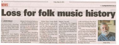
Newspaper - PETER ELLIS COLLECTION: NEWSPAPER ARTICLE, 22nd May, 2015
... on Bridge Street on Monday, May 25, at 11am, followed by a private... on Bridge Street on Monday, May 25, at 11am, followed by a private ...Newspaper article from the Bendigo Advertiser stuck on A4 printer paper. Article is dated Friday, May 22, 2015. Article is accompanied by a picture of Peter Ellis and is captioned as such. Article is written by Jason Walls and is titled Loss for folk music history. Article reads: Celebrated Bendigo Music identity, historian and naturalist Peter Ellis OAM died suddenly this week after a brief illness. He was 69. Mr Ellis was highly regarded as a collector and preserver of traditional bush music, with his collection of dance related material the largest in the National Library Archives in Canberra. He was award an Order of Australia Medal in 2012 for services to the arts through the collection and preservation of Australian folk history and heritage. Mr Ellis was a founding member of the Emu Creek Bush Band and achieved two platinum and several gold records in his more than 30 years with the Wedderburn Old Timers Band. Fellow Emu Creek Bush Band member and close friend John Williams said Mr Ellis had made an invaluable contribution to the preservation of Australia's musical and dance heritage, travelling extensively across the country recording and notating folk music. 'In 500 year's time, as long as they can find the technology, people will be able to resurrect our bush dancing history,' he said. 'Probably his biggest legacy is the number of young people who have been made aware of bush music and are continuing to play it today and will play it in the future.' As a life member of the Bendigo Field Naturalists Mr Ellis was also involved in campaigns to establish the Whipstick and Kamarooka State Parks and the Saloman's Gully and Jackass Flat Flora Reserves, and lobbied for the inclusion of One Tree Hill in the Greater Bendigo National Park. A public funeral service will beheld at the Mulqueen Family Chapel on Bridge Street on Monday, May 25, at 11am, followed by a private cremation. An extensive obituary will be published in Saturday's Bendigo Advertiser.person, individual, peter ellis oam -
 Flagstaff Hill Maritime Museum and Village
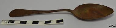
Domestic object - Spoon, Cooper Brothers, 1866-1932
... at Bridge Street and in 1885 they purchased the works at 44 Arundel... they were at Bridge Street and in 1885 they purchased the works ...This tablespoon was recovered from an unknown shipwreck in the coastal waters of Victoria in the late 1960s to early 1970s. The shipwrecks in the area range from around the 1840s to the early 1930s, and this particular spoon dates from about 1866 to 1932. It is part of the John Chance Collection. This spoon has the embossed names of Pompton and Silver and appears to have other marks that have worn off. The Pompton brand was used on silver flatware made by Cooper Brothers & Sons. Ltd of Sheffield. In Australia the Pompton Silver cutlery was advertised for sale in Sydney in the mid-1920s. The spoon is likely to be plated silver or silver plate, which is a base metal such as nickel or nickel alloy with copper and/or zinc that has been plated or coated with a thin layer of silver. Wear on the metal will cause the base metals to appear through the silver plating. Some manufacturers gave a warranty that the cutlery was ‘white throughout’ but didn’t necessarily say it was solid silver. Cooper Brothers was established in 1866 by brothers Thomas and John William Cooper in High Street, Sheffield. They bought Don Plate Works in 1872. By 1876 they were at Bridge Street and in 1885 they purchased the works at 44 Arundel St Sheffield. In 1895 the firm became Cooper Brothers & Sons Ltd. By 1914 they had branches in London, Sydney, Melbourne and Montreal, advertising as silversmiths, silver cutlers, electroplaters, Britannia Metal smiths and cutlers, particularly spoons and forks. The firm also used the trademarks of DON SILVER, POMPTON SILVER and a logo of a Cooper (barrel maker) in different formats. Cooper Brothers & Sons had a reputation for producing good quality silver and silver plate. In 1900 they registered their Maker’s Mark of the letters ‘CB&s’ within a shield. They also used the Sheffield Assay Hallmark of a Crown. A diagram on a Copper Brothers & Sons, Don Plate Works, advertisement showed three styles of cutlery; No. 393, Old English, and Fiddle. They announced that they were the ‘sole makers of the celebrated “Don” brand of nickel silver spoons and forks’. A burglary in NSW in 1929 listed a stolen flatware set as ‘all Sheffield Silver plate and branded Pompton Silver Works A.1.’. It was ‘guaranteed to wear white throughout’ and was a ‘good, medium quality, nickel silver line’. Cooper Brothers & Sons Ltd. was acquired in 1983 by Frank Cobb & Co. Ltd. Although the spoon is not linked to a particular shipwreck, it is recognised as being historically significant as an example of cutlery either as part of the ship’s flatware service or imported for use in Colonial Victoria in the 19th to early 20th century. The spoon is significant for its association with renowned makers Cooper Brothers of Sheffield, makers of silverware from the 1860s to the 1980s and exporters into the Colonies. The spoon is also significant as it was recovered by John Chance, a diver in Victoria’s coastal waters in the late 1960s to early 1970s. Items that come from several wrecks have since been donated to the Flagstaff Hill Maritime Village’s museum collection by his family, illustrating this item’s level of historical value. Spoon; plated silver tablespoon with brown base metal. Handle is Old English design and is embossed - some marks are worn and unidentifiable. Branded Pompton Silver.Embossed within two rectangular shapes “POMPTON” and “SILVER” (other marks have worn off)flagstaff hill, warrnambool, flagstaff hill maritime museum, maritime museum, shipwreck coast, flagstaff hill maritime village, great ocean road, john chance, cutlery, flatware silver, silver plate, antique flatware, old english flatware pattern, eating utensils, spoon, tablespoon, silverware, dining utensil, cooper brothers, don plate works, pompton silver, sheffield silver -
 Puffing Billy Railway
Bread Plate, Victorian Railways Black & White, June 1953 "6-53" = "month-year"
... Bridge Street, Melbourne South Advertising (29 March 1933... Specialists, 131 Queen's Bridge Street, Melbourne South Advertising ...Victorian Railways Bread Plate - Black & White Maker : W H Grindley & Co (Ltd) Earthenware manufacturer at the Newfield Pottery and then the Woodfield Pottery, Tunstall, Stoke-on-Trent The company was founded at the Newfield Pottery in 1880 by William Harry Grindley (princliple partner) and Mr Turner (the '& Co.') They produced Earthenware and Ironstone China - particularly for the Canadian, United States, South American and Australian markets. In 1891 the company moved to the Woodfield Pottery, Woodland Street, Tunstall. In 1960 the business was purchased by Alfred Clough Ltd. In 1978 renamed Grindley of Stoke (ceramics) Ltd. Federated Potteries Co. Ltd. took them over in 1982 and in 1988 the business was re-purchase by W. H. Grindley. 1991 saw the company in the hands of the receivers. and the same year they were taken over by Woodlands Pottery. DURALINE (trade mark) printed mark used by Grindley Hotel Ware Co Ltd c.1930's onwards The Number i.e "6-53" = "month-year" Supplier to Victorian railways : Loftus Moran, Melbourne: Mr Loftus Henry Moran was well known in the tea trade. Originally employed by Griffiths Bros Ltd, he started his own business, Loftus Moran Pty Ltd, in 1909 In 1913 he purchased the tea business of Mcintyre Bros, and later' that of Steele Bros, and absorbed them in his own company. He had a wide business connection among hotels and guest houses for supplying crockery and other supplies. Ref: DEATH OF MR LOFTUS MORAN (1944, May 27). The Argus (Melbourne, Vic. : 1848 - 1957), p. 4. http://nla.gov.au/nla.news-article11809686 1st Advertisement of the Plates in the papers: CHIPPED CROCKERY. Nothing is more objectionable than chipped crockery--besides its use is illegal. DURALINE Plates, manufactured by The Grindley Hotel Ware Co., are tough as raw-hide. This is why they are used by practically every hotel and institution in Australia. Obtainable only from LOFTUS MORAN PTY. LTD., Hotel Supply Specialists, 131 Queen's Bridge Street, Melbourne South Advertising (29 March 1933, ). The Argus (Melbourne, Vic. ), p. 7. http://nla.gov.au/nla.news-article4726734Historic - Victorian Railways - Refreashment Services crockery - plateceramic Victorian Railways Bread Plate - Black & White Victorian Railways ( in black on fount of plate ) "DURALINE" ( in Black on back of plate ) super Vitrified GRINDLEY HotelWare Co England Loftus Moran Pty Ld Melbourne 8 -53puffing billy, victorian railways, crockery, plate -
 Ballarat Tramway Museum
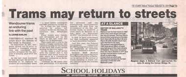
Newspaper, The Courier Ballarat, "Trams may return to streets", 20/09/2001 12:00:00 AM
... is of 31 at Main and Victoria streets, in Bridge St. Written..., in Bridge St. Written by Leonie Barlow, "Trams may return to streets ...Newspaper clipping from The Courier Ballarat, Thursday 20/9/2001, page 15, titled "Trams may return to streets", about the 30th anniversary of the closure of Ballarat Tramways, the possible return, and the feasibility study also being undertaken. Also has a paragraph giving a very potted history of the tramway, "History of Ballarat's trams". Photo with article is of 31 at Main and Victoria streets, in Bridge St. Written by Leonie Barlow,closure, ballarat, tram revival -
 Melbourne Tram Museum
Photograph - Set of 5 Black & White - First AETA tour, 15-2-1947
... Bridge in Swan Street with the Burnley Gardens on the right.... to the east of Yarra River Bridge in Swan Street with the Burnley ...Set of five photographs of the first Australian Electric Traction Association (AETA) tram tour of Melbourne on 15/2/1947. See page 8 of the March 1947 issue of "Tram Tracks" for details of the tour and the MMTB Crew. 1 - SW6 881 about to leave Glen Huntly Depot 2 - Crossing Balaclava Junction 3 - Crossing the Kooyong railway level crossing in Glenferrie Road - has the railway signal box and gates in view. 4 - Turning into Riversdale Road from Glenferrie Road with the Stotts Business College building in the background. 5 - Just to the east of Yarra River Bridge in Swan Street with the Burnley Gardens on the right.Yields information about the first AETA tram tour in 1947Set of 5 Black and white photograph on paper. Two copies of each held.Each one of the set has a photographers file stamp on the rear, but no details filled in.trams, tramways, aeta, tram tours, tram 881, sw6 class, glen huntly, kooyong level crossing, glenferrie road, riversdale road, burnley, hawthorn, balaclava junction, glen huntly depot, hawthorn road, swan st -
 Federation University Historical Collection
Document - Documents, Golden Point - Mount Pleasant Progress Association Establishment
... person or organisation in the area generally bounded by Bridge... or organisation in the area generally bounded by Bridge mall and Skipton ...The Golden Point - Mt Pleasant Progress Association was established on Wednesday 6 April 1983. Membership was open to any person or organisation in the area generally bounded by Bridge mall and Skipton Street, Elsworth Street and main Road. annual family or organisation membership was $2.00. Mara Gluyas served as secretary of the Golden Point - Mt Pleasant Progress Association from 1983 to 1994. Ian McKinnon was the President from 1983 to 1992. Kerry Daniels was the President in 1994.A small white cardboard box with purple lid of A4 documents relating to the establishment of the Golden Point - Mt Pleasant Progress Association. The documents include the original constitution and minutes. Topics include: Pearce's Park; removal of elms, names and addresses of members, Sovereign Hill realignment; Sovereign Hill Lookout; membership form; Golden Point Historic Mines Direction Indicator; Ballarat Observatory; Nerrina Tip; Yarrowee Creek; Mine Capping (Sovereign Mine); tree planting (Sovereign Hill Lookout); Magpie Street Park; Hill Street; Yarrowee Flora Park; Barkly Street; South Street Bluestone Gutter; Ballarat Goldfields; Eastern baths site; Grant Street; Flooding; Aboriginal Advancement League; Sunnyside Woollen Mill; Chinese Garden; Golden Point Primary School closure; Ballarat West Goldfields; Sovereign Hill Land Title and Management Revision; Wainwright; Street; Llanberris; Yuille's Station Parkgolden point, mount pleasant, mt pleasant, ian mckinnno, mara gluyas, peter hiscock, frank williams, geoff howard, leigh gillett, sovereign hill, kerry daniels, norm strange; graeme kent; george netherway; keith rash; ian mckinnon, albert graham, bryan crebbin, jim humphreys. wid radbourn, heath martin, janet dore, alex mills park