Showing 10896 items
matching land
-
 Ringwood and District Historical Society
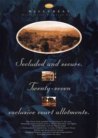
Flyer, Land Sale Advertisement, Hillcrest Heron Court, Ringwood North, Vic. - c.1994
Double sided A4 gloss print advertisement with subdivision map showing location and size of 27 residential allotments and A4 price list page for 14 Lots.Price list includes comment that "construction shall commence in September, with completion in December. Titles Office registration would be expected in January. (No mention of year/s, circa early to mid 1990s). -
 Ringwood and District Historical Society
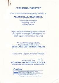
Flyer, Land Auction Advertisement, Talinga Estate, Allens Road, Heathmont, Vic. - 1985
Double sided A4 page with subdivision map showing location and size of allotments for auction on Saturday 3rd August (1985). Agent - C.E. Carter & Son Pty. Ltd., 122 Whitehorse Road, Ringwood 3134, Telephone 870 6211.Handwritten sale price annotations - Lot 1 Sold $42,000, Lot 2 Sold $42,200, Lot 3 Sold $41,500, Lot 4 Sold $53,000. -
 Merbein District Historical Society
Document, Merbein Cemetery Land Application Report, 1911
cemetery fees, cemetery regulations, cemetery correspondence -
 Eltham District Historical Society Inc
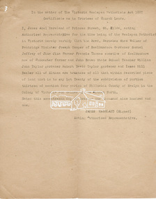
Document, Certificate as to Trustees of Wesleyan Church land, Lot 20 Henry Street, Little Eltham North, 7 Oct 1901
The Trustees for Lot 20 Henry Street were declared by the Wesleyan Methodist Church on 7 October 1901 to be Revd. Barnabas Shaw Walker, Minister of the Pentridge Circuit, Joseph Cooper, Gardener of Keelbundora, Samuel Jeffrey, Farmer of Jika Jika, Francis Thomas, Farmer of Doncaster and sometime of Keelbundora, John Brown, State School Teacher, William John Taylor, Gardener, Robert David Taylor, Gardener and Isaac Hill, Dealer, all of Eltham. Originally purchased in 1856 from Thomas Roberts, Yeoman of Little Eltham, for £10 for use by the Wesleyan Chapel, represented by indentured Trustees, Rev. Barnabas Shaw Walker, Minister of the Pentridge Circuit, Francis Thomas, Farmer of Keelbundora, William Harriman, Blacksmith of Nillumbik, Nicholas Rodda, Farmer of Nillumbik, Aaron Grimshaw, Farmer of Greensborough, Joseph Cooper, Gardener of Keelbundora, Peter Dredge, Scholmaster of Jika Jika and Samuel Jeffrey, Farmer of Jika Jika. Lot 20 of Subdivision of Portion 13, Section 4 of the Parish of Nillumbik in the County of Evelyn was located on the southern side of Henry street in Little Eltham North, where the current Our Lady Help of Christians Catholic Church is situated. It became the location of the Eltham Rechabite Hall. In 1893 a new hall was built and further enlarged in 1919. At the commencement of 1922, the property was purchased from the Independent Order of Rechabites with publicly subscribed funds and a new hall built at a cost of £750 and improved road access constructed to reduce the grade, running from Dudley Street to Henry Street. This hall was eventually replaced with the new Shire Offices and Hall built on the corner of Arthur Street and Main Road, which was opened in 1941. Traces the earliest history of the Eltham Public Hall in Henry Street and the various names, occupations and abodes of the Trustees associated with the propertyeltham public hall, eltham rechabite hall, eltham wesleyan chapel, francis thomas, henry street, james abel marsland, james massland, john brown, joseph cooper, little eltham north, rev barnabas shaw walker, robert david taylor, samuel jeffrey, trustee, william john taylor, little eltham, isaac hill -
 Ringwood and District Historical Society
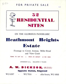
Flyer, Land Sale Brochure, Heathmont Heights Estate, Heathmont, Vic. - 1959
Bi-fold advertisement for sale of residential sites, including map and summary of subdivision features and local facilities. Subdivision includes Coven Avenue, View Court, and Miller Road. Agent - A.W. Dickson, Opposite Station. (Phone) WU6007, WU7016, after hours WU6868. Accompanying Titles Office Plan of Subdivision photocopy dated 1971 - Part of Crown Allotment 38A Parish of Ringwood. -
 Warrnambool RSL Sub Branch
Book, BOOK: War Dog : The no-man's-land puppy who took to the skies
-
 Ringwood and District Historical Society
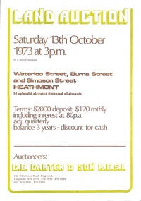
Document - Folder, Land Auction - Peacock's Estate, Waterloo Street, Heathmont, Victoria - 1973
Photocopy of Certificate of Title and double sided bi-fold leaflet advertising auction of 14 allotments on 13th October 1973 with map of streets, summary of local services and terms of sale. Subdivision includes Waterloo Street, Burns Road (later Dirkala Avenue), and Simpsons Road (later Simpsons Court). Auctioneers - C.E. Carter & Son R.E.S.I. 126 Whitehorse Road, Ringwood, Telephone 870 2519, 870 6830, 870 6024, A.H. 870 0421, 870 3568.Auctioneer's notation of sale prices included on brochure - all sold on day of auction. Vendor Frank Harry Peacock, Tile Burner, named as proprietor of Lot 12 on Plan of Subdivision No. 95654 on Title (Vol 8999 Fol 058). Map shows Dandenong Creek Watercourse as at September, 1971, prior to Dandenong Creek Trail development. -
 Ringwood and District Historical Society
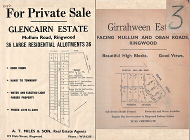
Document - Folder, Land Sale Advertisement, Glencairn Estate and Girrahween Estate, Ringwood - circa 1950s
Single sided advertisement for private sale of residential allotments - undated, circa 1950s.Subdivisions include Mullum Mullum Road,Glen Cairn Avenue (Glencairn), Oban Road, and Norman Avenue (later Hugh Street). Agent - A.T. Miles & Son, 175 Main Street, Ringwood, Phone WU 6215. -
 Ringwood and District Historical Society
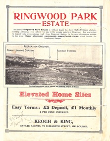
Flyer, Sub-divisional residential land sale advertisement - Ringwood Park Estate, Ringwood, Vic. - circa 1922
Folded double-sided page with black and white photographs of local views with black and red print advertising elevated home sites, including terms of sale, locality map, and description of local facilities and services, with blocks marked as SOLD subsequent to auction sale December 1922. (See Record ID no.5249)Subdivision includes Wonga Road (later Loughnan Road), William Street, Andrew Street, Munro Street and Harrison Street. Estate Agents - Keogh & King, 70 Elizabeth Street, Melbourne, Telephone 6938. -
University of Melbourne, Burnley Campus Archives
Newspaper - Newspaper Cutting, The Age, No High School on park land, 1967
Article in "The Age" 05.08.1967 about the scrapping of a proposal to build a new high school in the park behind Burnley Horticultural College.the age, burnley school of horticulture, new school proposal, richmond park -
 University of Melbourne, Burnley Campus Archives
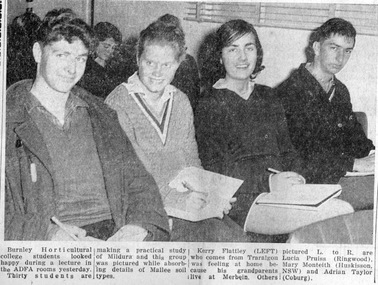
Newspaper - Newspaper Cutting, The Sunraysia Daily, Studying the Land, 1964
Photograph in "The Sunraysia Daily" May 27, 1964. 4 Burnley students who are part of a group of 30 students who are making a practical study of Mildura. They are attending an ADFA lecture on Mallee soil types. They are: Kerry Flattley, Lucia Pruis(s) (sic), Mary Monteith and Adrian Taylor (all 1966).sunraysia daily, students, mildura, kerry flattey, lucia pruiss, mary monteith, adrian taylor, adfa lecture, sojourns, excursions -
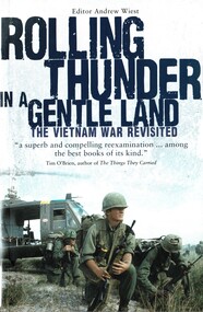 National Vietnam Veterans Museum (NVVM)
Book, Wiest, Andrew, Rolling Thunder In A Gentle Land: The Vietnam War Revisited (Copy 2)
A superb and compelling reexamination...among the best books of its kind.A superb and compelling reexamination...among the best books of its kind.vietnam war, 1961-1975, vietnam -- history -- 1945-1975, french indochina war, cambodia, laos, south vietnamese soldier, anzac, people's army of vietnam, ho chi minh trail, lt gen lam quang thi -
 National Vietnam Veterans Museum (NVVM)
Book, Wiest, Andrew, Rolling Thunder In A Gentle Land: The Vietnam War Revisited (Copy 1)
A superb and compelling reexamination...among the best books of its kind.A superb and compelling reexamination...among the best books of its kind.vietnam war, 1961-1975, vietnam - history - 1945-1975, french indochina war, people's army of vietnam, ho chi minh trail, cambodia, laos, lt gen lam quang thi, south vietnamese soldier -
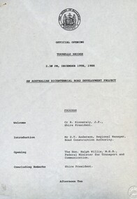 Federation University Historical Collection
Document - Documents, Tourello: Opening of Tourello Bridge; Tourello Hunt Club, 1909; Tourello Tennis Club; Government Land Auction, 1855
Maps and typed documentstourello bridge, hunt club, tennis club, government land auctions, talbot, clunes, coghill, lenaghan, peter lalor, r. kinnersly, d.t. anderson, ralph willis, creswick -
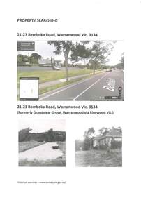 Ringwood and District Historical Society
Archive - Parent Record, Family History - Collection of 1960s Land Titles and Property Records associated with Carter and Brown Families and others, Grandview Grove, (later Bemboka Road) Warranwood, (Parts of Crown Grant 20, 1854)
Set of four clear-fronted plastic A4 binders containing family history research printouts and photocopies. -
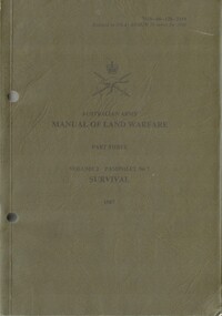 National Vietnam Veterans Museum (NVVM)
Booklet, Australian Army, Australian Army: Manual of Land Warfare, Part Three: Volume.2, Pamphlet No.7: Survival 1987, 1987
An khaki green cardboad cover with black information on it. There is the Australian Army insignia with the details of the booklet under it. Top right hand side reads: 7610-66-128-2159. There are two punch holes down the left hand side.australia - armed forces - service manuals, military education, survival, land warfare -
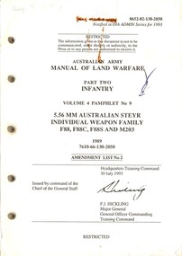 National Vietnam Veterans Museum (NVVM)
Booklet, Australian Army, Australian Army: Manual of Land Warfare, Part Two Infantry: Volume 4 Pamphlet No.9: 5.56 MM Australian Steyr individual Weapon Family F88, F88C, F885 and M203: Amendment List No. 2, 1989
A booklet without a cover which is held together by a metal bulldog clip. The infomation on the front is in black. Top Right Hand reads 0652-02-130-2050 There are five punch holes down the left hand side.australia - armed forces - service manuals, land warfare, 5.56mm australian steyr, infantry -
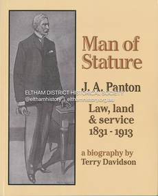 Eltham District Historical Society Inc
Book, Terry Davidson, Man of Stature : J.A. Panton Law, Land and Service 1832 - 1913, 2024
Joseph Anderson Panton lived through the entire reign of Queen Victoria and in over 60 years of being in Australia saw the country advance from the earliest gold-rush days through to the first decade of Federation. Arriving from Scotland intending to pursue a pastoral life in Victoria, the discovery of gold dramatically changed that direction for the 20 year-old student, fresh from a military Academy education.Not a bystander to the myriad of events of the era, he soon carved out a life of some significance in the administration of justice in the dramatic early days and maturing of Sandhurst (Bendigo), then advancing through by postings to country regional areas and finally become extremely well known as Melbourne's Police Magistrate for some 30 years until his retirement in 1907. joseph anderson panton, magistate, gold commissioner, eltham, north warrandyte, glynns reserve, police magistrate -
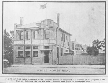 Ringwood and District Historical Society
Photograph, Maroondah Highway Central, Ringwood. Land sale brochure image of the State Savings Bank of Victoria branch and manager's residence, 1923
Black and white copy of photographTyped below photograph: "White Horse Road" and statement underneath reads, "Photo of the new Savings Bank recently erected at Ringwood. An evidence of the progress of the District. Buildings like this are more eloquent than pages of Newspaper Talk." -
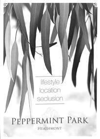 Ringwood and District Historical Society
Flyer, Residential Land Sale Brochure, Peppermint Park, Heathmont, Vic. - 2010
Double-sided A3 size advertisement for Peppermint Park, Heathmont, Victoria, advertising sale of ten homesites with diagram showing locality map, size of blocks and layout of streets within and around the subdivision.Subdivision layout includes Pleasant Drive, Swain Court and Barbara Court off Culverlands Road and Armstrong Road in Heathmont. Agents - Carter Real Estate Agency, 90 Maroondah Highway, Ringwood Vic 3134 (Telephone) 98706211. Auctioneers - Richard Carter & William Lyall - 0411823337. Handwritten price list notations included, and Stage 2 Plan digitally signed by Michael Herwald Hipfel, Licensed Surveyor, 10/2/1916. -
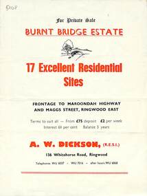 Ringwood and District Historical Society
Flyer, Land Sale Brochure, Burnt Bridge Estate, Ringwood East/Croydon, Vic. - circa 1959
Bi-folded single sheet with black and red print both sides including subdivision features and local facilitiesSubdivision layout includes Marcus Road, Maggs Street and Maroondah Highway Croydon/Ringwood East. (Agent) A.W. Dickson, 136 Whitehorse Road, Ringwood, Telephones WU 6007, WU 7016, after hours WU 6868. -
 Ringwood and District Historical Society
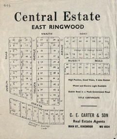
Flyer, Land Sale Advertisement, Central Estate, East Ringwood - 1948
East Ringwood Central Estate auction sale of allotments previously advertised for Saturday October 23rd (1948). Victorian Collections reference 5138 refers.Single sided leafletSubdivision includes Dublin Road, Knaith Road, Talofa Avenue, Russet Road, and Shasta Avenue. Agent - C.E. Carter & Son, Main Street, Ringwood. WU 6024. -
 Ringwood and District Historical Society
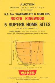
Flyer, Land Auction, Cnr Warrandyte and Oban Roads, North Ringwood, Vic. - 1974
Single yellow page advertising Auction of five home sites to be sold separately on Saturday, 11th May, 1974. Details include vendor terms, subdivision services, and location map (north-east corner of Warrandyte and Oban Roads).(Agent) Eric Weber & Co. Pty. Ltd., 148 Wellington Parade, East Melbourne, 3002, Phone: 416025, Mr Elliott A.H. 8577502. Later handwritten notation suggests vendor was possibly Country Roads Board (VicRoads) after completion of road widening works. -
Lakes Entrance Historical Society
Book, South Gippsland Development League, Land of the lyrebird, 1966
A story of early settlement in the great forest of South Gippsland including fauna hardships experienced by the early explorers and settlers and the settling and development of this once hostile and impenetrable part of Victoria. IllustratedRuth Clarkexplorers, settlers, fauna -
 Ringwood and District Historical Society
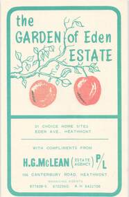
Flyer, Land Sale Brochure, Garden of Eden Estate, Heathmont. Circa 1966-67
Small buff-coloured leaflet with green print advertising 31 home sites for sale, with summary of subdivision features and services available. Subdivision includes Eden Avenue and Dirkala Avenue, Heathmont. Managing Agents - H.G. McLean P/L, 166 Canterbury Road, Heathmont. (Tel) 877808-9, 8702560, 8422708. £100 or $200 Deposit. Terms £18 or $36 monthly, balance over 4 years. Interest 7% quarterly adjusted. 5% discount for cash. -
Lakes Entrance Historical Society
Book, Town and Country Planning Board Melbourne, Gippsland Lakes Land Use Strategy Plan, 1978
Background report to the strategy plan to guide future development of the Gippsland Lakeswaterways, recreation -
Lakes Entrance Historical Society
Book, Hollole, H.N, Land of the '' Boong', 1944
30 sketches of Papua, drawn during the artist's duty with the Australian Forces in Papua-New Guinea 1942-44world war 1939 - 1945 -
University of Melbourne, Burnley Campus Archives
Plan, Plan showing land required for Road Purposes from the temporary reservation for Horticultural Gardens at Richmond. John S. Jenkins Town Surveyor Richmond. 1st April 1880, 1880
Framed and glazed copy of B92.0540.gardens, richmond, hoticultural society of victoria -
 Merri-bek City Council
Painting - Oil on linen, Renee Cosgrave, Learning Whakapapa (Māori Land Court Archives), 2023
-
Lakes Entrance Historical Society
Book, The Park by Land and Sea, 1995
A history of the Methodist Church Camp Park at Lake Tyers Beach, from the original property owners to the management by the Uniting Church.tourism