Showing 12221 items matching " reserves"
-
 Greensborough Historical Society
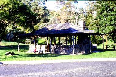
Slide - Photograph, John Ramsdale, Picnic shelter, Pioneer Reserve: Slide 22, 1990s
Photograph shows Pioneer Reserve picnic shelter in Greensborough. This shelter was built from bluestones from the old bridge over Plenty River.Part of the John Ramsdale collection of slides and audio visual material.Colour photograph scanned from slide.No maker's marks. No caption on slide.plenty river, bluestone bridge greensborough, pioneer reserve greensborough -
 Greensborough Historical Society
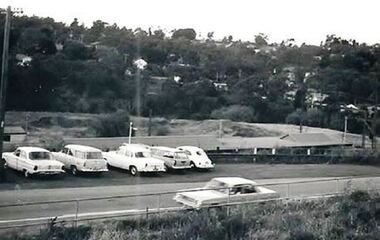
Photograph - Digital Image, Across Greensborough Station, 1973c, 1973c
Looking across Greensborough Station. Taken from Varalla's corner Para Road and Flintoff Street. Turning Pope's Paddock into the Poulter Reserve.Digital copy of black and white photograph. trains, greensborough station, popes paddock, poulter reserve greensborough -
 Greensborough Historical Society
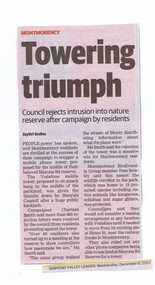
Newspaper Clipping, Diamond Valley Leader, Phone Tower Failure - A Towering triumph, 06/12/2017
People power has spoken, and Montmorency residents are thrilled at the success of their campaign to scupper a mobile phone tower in their beloved Mayona Road reserve.News article 1 page, black text.montmorency, mayona road montmorency, vodafone, mobile phones, phone towers -
 Greensborough Historical Society
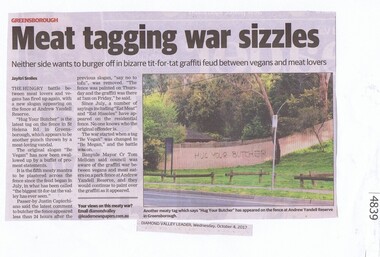
Newspaper Clipping, Diamond Valley Leader, Meat tagging war sizzles, 04/10/2017
The hungry battle between meat lovers and vegans has fired up again, with a new slogan appearing on the fence at Andrew Yandell Reserve.News article 1 page, black text, colour image.andrew yandell reserve, greensborough, graffiti, banyule council, yandell reserve -
 Halls Gap & Grampians Historical Society
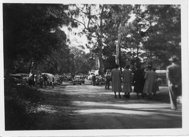
Photograph - B/W, C 1950
Halls Gap Grampians Camping reserve on Flower Show Day in 1950. This is the main road looking towards the stores from Grampian House.The photo shows a road with trees growing on either side. There are cars parked on either side of the road and people standing and walking along the road. In the centre there are two cars driving along the road towards the camera.events, wildflower show -
 Port Melbourne Historical & Preservation Society
Banner - Port Melbourne Citizens Action Group, Citizens Action Group
Made during the group's campaigns against the loss of railway, the SCDC Bayside development, Council amalgamations and building of road through Railway Reserve.Banner reading 'Port Melbourne Citizens Action Group Fighting for your Rights' '*Market redevelopment * Station Pier *Light rail *Freeway *Your Council' Hand painted onto flannel sheeting in back, purple, red, green and blue; edges hand-boundpublic action campaigns, societies clubs unions and other organisations, town planning - proposals shelved - bayside, ian mckay, citizens action group -
 Stawell Historical Society Inc
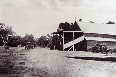
Photograph, Grandstand at Old Botanic Reserve c1928
Grandstand attached to Stawell Brewery at Old Botanic Reserve. C1928. Taken from "Souvenir of the Diamond Jubilee of Borough of Stawell 1869-1929"stawell -
Box Hill Historical Society
Photograph - Hagenauer's Reserve, Elgar Road, Box Hill
Hagenauer's Reserve, Elgar Road, Box Hill, between Willow Street and Barwon Street. Sports ground for Box Hill Athletic Club.hagenauer reserve, box hill athletics club, sport, elgar road, willow street, barwon street, sportsgrounds, athletic clubs, parks and reserves -
 Whitehorse Historical Society Inc.
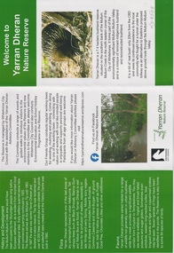
Pamphlet, Yarran Dheran, 26/02/2025
4 pamphlets 1. Welcome to Yarran Dheran Nature Reserve 2. Stepping Stones for Wildlife 3. Birds of Yarran Dheran 4. Butterflies4 pamphletsnon-fiction4 pamphlets 1. Welcome to Yarran Dheran Nature Reserve 2. Stepping Stones for Wildlife 3. Birds of Yarran Dheran 4. Butterfliesyarran dheran, city of whitehouse -
 Bayside Gallery - Bayside City Council Art & Heritage Collection
Map, H.B. Foot, Plan of the Brighton Estate containing 5120 acres, first special survey at Port Phillip, c. 1842
This plan records the Brighton Estate, also known as Dendy's Special Survey. In 1840 Henry Dendy, a farmer in Surrey, England acquired a "Special Survey" from the Commissioners for Land and Emigration which gave him the right to choose land in Port Phillip for the low price of £1 per acre for 5120 acres. Dendy appointed Jonathan Binns Were, as his agent, who later became a partner. Together, Dendy and Were decided on an area 5 miles south from Melbourne, bounded by North Road, East Boundary Road, South Road and to the west by Port Phillip Bay. Their Brighton Estate was first surveyed by T. S. Townsend in May 1841 and was re-surveyed by Robert Hoddle. Dendy and Were were making plans to sell the land and advertised a 30-guinea prize for the best subdivision which was to be divided into a village, marine residences, suburban and cultivation allotments, with the remainder being divided into country sections. The competition was won by H.B. Foot, who planned the village around a reserve and crescents and a 'green belt' forming the town boundary. brighton estate, dendy's special survey, special survey, henry dendy, jonathan binns were, w.b. were, survey, plan, map, brighton, george ward cole, baker's lithographer, hibernian, subdivision, town planning, cartographic material, h.b. foot -
 Greensborough Historical Society
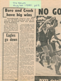
Newspaper Clipping, Diamond Valley Leader, Boro and Creek have big wins, 26/08/1980
This article reports the results of the 1980 elimination final in which Greensborough Reserves won against North Heidelberg. Includes other match results for the day.Photocopy of news clipping.greensborough football club -
 Hume City Civic Collection
Photograph
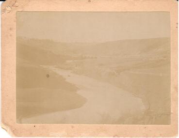
Deep Creek running from school to reserve where swimming took place. One of a series of 4 photographs of the Bulla Valley and Deep Creek.Faded black and white photo of Deep Creek. Mounted on cardboard.deep creek, bulla bridge, waterways, bulla, george evans collection -
Clunes Museum
Programme - SOUVENIR PROGRAMME, WALLIS & GIDDINGS GUARDIAN PRINTERS CLUNES, 1902
CHILDREN FROM CLUNES SCHOOLS ASSEMBLED AT CLUNES TOWN HALL TO RECEIVE COMMERATION MEDALS, THEN MARCH TO ISLAND RESERVE HEADED BY BOROUGH CLUNES BANDPROGRAMME OF CELEBRATIONS BY THE PEOPLE AND CHILDREN OF BOROUGH OF CLUNES 26 JUNE 1902 IN COMMERATION OF CORONATION OF KING EDWARD VIIlocal history, document, performing arts, events and celebrations, performing arts -
 8th/13th Victorian Mounted Rifles Regimental Collection
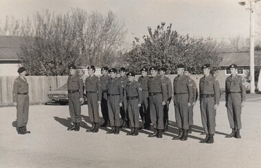
Photograph
In 1970s Army Reserve Units carried out their own recruiting and NCO training. RSM Kennard was a member of the 8/13 VMR Cadre staff.Fine study of Army Reserve soldiers at Albury 1970s.Black and White photograph of soldiers in two ranks with instructor in front" NCO Course, Albury, RSM WO1 Kennard " List of some members of squad follows. -
 8th/13th Victorian Mounted Rifles Regimental Collection
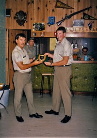
Photograph - Cobram mess
Army Reserve regiments had ARA officers and senior NCOs posted to them for training and administrative purposes. The duration of the posting was usually two yearsRecords a presentation of memento in soldiers' messColour photograph of Lance Corporal Mahony, " A " Squadron 8/13 Victorian Mounted Rifles presenting a plaque to Cadre Staff Sergeant Whitney on his departure from Salamaua Barracks Cobram December 1987.military, mess, cobram, salamaua barracks, vmr -
 8th/13th Victorian Mounted Rifles Regimental Collection
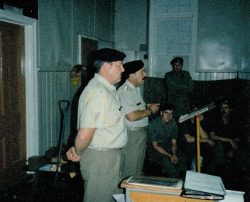
Photograph
Army Reserve regiments had ARA officers and senior NCOs posted to them for training and administrative purposes. The duration of the posting was usually two years.Four colour photographs taken at Buna Barracks Albury when Major Robert Morrison farewelled 4 members of the 8/13 Victorian Mounted Rifles Cadre Staff: Sergeant King, Corporal Greg Nye, Sergeant Jim Whitney and Sergeant Len Scott. -
 Ballan Shire Historical Society
Map - Map. Bullarook State Forest, Bullarook State Forest Reserve
A small map of the Bullarook State Forest Reserve. Drawn on a fine buff coloured paper attached to a stiff cloth backing sheet. The title is hand written and includes a "scale one mile to one inch" hand written also. The map is signed "John Wrigglesworth, assistant ? and dated 26/6/1869" although the month and year are almost illegible.moorabool west, state forest, bullarook, eastern moorabool river, werribee river, moorabool east, blakes saw mill, wombat, andersons saw mill -
 Bendigo Military Museum
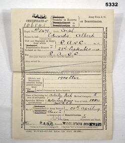
Document - CERTIFICATE of TRANSFER, British Army, BRITISH ARMY CERTIFICATE OF TRANSFER TO RESERVE ON DEMOB, 1919
Refers to Service of Albert Edwards This is a small sheet of strong paper. It was white paper and the print is in black ink. British Army Form Z.24. It is for MJ/5471 Cpl Edwards, Albert. DOE: 23 Sep 1914 RASC. DOB 1884. MIL trades Motor Lorry Driver, Good NCO. Transferred to Army Reserve (UK) 20 Apr 1919. Certificate NR 106843. Stamped RASC. Woolwich Dockyard.ww1, certificate of transfer -
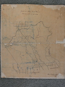
 Ringwood and District Historical Society
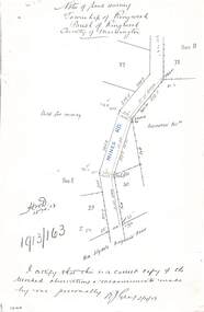
Document - Copy of Lands Department Field Notes - Township of Ringwood, Victoria, Field Notes 1913/163 - Part of O.P. R72D surveyed April 1913
5612b Foolscap size photocopy of survey map with handwritten notations. References include Mines Road, New Lilydale Road (Maroondah Highway), (area) Held for mining, Recreation Reserve, Sec D, Sec E, I certify that this is a correct copy of the recorded observations & measurements made by me personally (signed) R.J. Gray 2/4/13. -
 Ringwood and District Historical Society
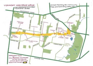
Pamphlet - Map and Guide Notes, Vermont Heritage Walk, Vermont, Victoria - 2022
Double-sided A4 map and 9-page A4 guide notes with QR codes outlining historical and environmental points of interest for participants' walking tour of "Healesville Freeway Reserve" between Springvale Road and Boronia Road, Vermont, Vic - 3.5km, 50 minutes each way. Vermont Heritage Walk map and notes produced by Evie and Hardy Kielnhofer. -
 Bendigo Historical Society Inc.
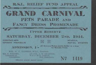
Document - W. BABIDGE COLLECTION: R.S.L RELIEF FUND APPEAL TICKET
Blue R.S.L. Relief Fund Appeal Pets Parade and Fancy Dress Promenade Ticket No. 1419. Held at the Upper Reserve Saturday, December 2nd, 1944. Col. G, V, Lansell, M. L. C., President. Mr. R. Wright, Chairman of Committees, Lt.-Col. J. W. Swatton and W.O.2 Max Lomax, Hon. Organisers.Sparkman, Printer, Bendigo Arcadedocument, w babidge collection - rsl relief fund appeal ticket, col. g v lansell, mr r wright, lt.-col j w swatton, wo2 max lomax, sparkman -
 Bendigo Historical Society Inc.
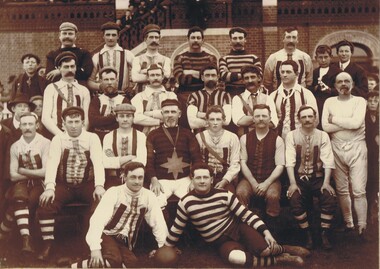
Photograph - PORTRAIT - MEN'S SPORT TEAM, circa 1900
Photograph - black and white. Portrait of a men's sport team. Some in the same stripe socks and tops and the other in tops stripes going the other way. A man in the middle wearing around his neck a very large 'star' type pendant. Written on back of photo, 'Identity of Team unknown #1900'. Photo taken at the Upper Reserve (now QEO).W H Robinson.organization, club/society, sport, sports team. all male. -
 Bendigo Historical Society Inc.
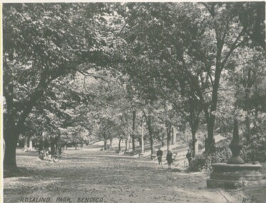
Photograph - VIEWS OF BENDIGO
Photographs - 8 of (small) black & white. Photo's of Pall Mall (no.22), Civic Buildings (no.1), The Baths Upper Reserve (no.13), Alexandra Fountain (no.6), Conservatory Gardens (no.29), City Hall (no.8), Central Deborah Mine (no.19), Rosalind Park (no.5). Handed in by Barry & Vicki Mulvena of 48 Lord St.,m Roseville, NSW 2069.Valentine's Snapshots.place, bendigo, picturesque views of bendigo., views of bendigo. -
 Bendigo Historical Society Inc.
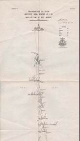
Map - STRUGNELL COLLECTION: HUSTLER'S LINE OF REEF, BENDIGO, September 1913
Map, Hustler's Line of Reef, Hustler's Royal Reserve No. 2 Co, Bendigo,Transverse Section, Plate No.V11 (7). Bulletin No 33 Signed H.A.Whitelaw Underground survey Office Bendigo September 1913 Drawing shows mine shaft to over 1640 feet deep and appears to show samples of connecting horizontal shafts with their respective mineral contentsUnderground Survey Office, Bendigo.map, bendigo, hustler's royal reserve no. 2 mine* -
Port Melbourne Historical & Preservation Society
Photograph - Three employees of Swallow & Ariell in uniform and cap on beach, 1930s - 1940s
Photocopy from two snapshots loaned by Laura Irving McGILL in 1990. Three employees of Swallow & Ariel in uniform and cap on beach. May IRVING, centre, 1939 and Daisy IRVING with baby nephew John McGILL 1940s in rose garden then in Turner reserve. Laura Irving McGILL in background, and Irving family home at 41 Station St across the road.Ink - "S&A" "Rose Garden" Pencil : descriptionsparks and gardens, families, industry - food, may irving, daisy irving, laura mcgill nee irving, john mcgill, swallow & ariell ltd -
 Bendigo Historical Society Inc.
Document - MCCOLL, RANKIN AND STANISTREET COLLECTION: SOUTH DEBORAH GOLD MINES NL GOLD LEASE DOCUMENT, 14/1/1941
Document: McColl, Rankin and Stanistreet - South Deborah Gold Mines NL. Gold mining lease document. No. 11141, Vol. 325, Fol. 35893. Lease adjoins Railway Reserve, Breen Street. Attached to plan with pin piece of paper, written in pencil ' application Atherton 14/4/46 - consent refused - hand drawn map with Honeybone Street.organization, mining, south deborah gold mines nl, mccoll, rankin and stanistreet, south deborah gold mines nl, gold mining lease documents -
Whitehorse Historical Society Inc.
Document, Zander Avenue, 7/01/1986
Memories by Merle Duncan recorded 7/1/1986. Zander Avenue named after the Zanders who had an apple orchard there. Wright Family owned a milk bar in Springfield Road and they built Mountain view shops in Springfield Road. The old manse, now the Nunawading North Community House was their home. Nicoll Reserve was a pear orchard owned by the Aytons.roads and streets, zander avenue, nunawading, nunawading, duncan, merle, wright family, mountain view shops, springfield road, nunawading, nicoll reserve, ayton family, zander family -
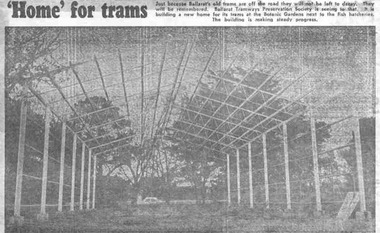 Ballarat Tramway Museum
Newspaper, The Courier Ballarat, " 'Home' for trams", 16/05/1972 12:00:00 AM
Yields information about the construction of the depot building for the BTPS in the south Gardens Reserve and the landscape at the time.Newspaper clipping from The Courier, Ballarat, dated Tuesday, 16/5/1972 titled " 'Home' for trams". Features a photograph of the erected steelwork for the new BTPS tram depot in the South Gardens Reserve. One of a large group of newspaper cuttings from John Bainbridge, 7/4/02. See Reg Item 3819 for a print of the actual photograph.btps, depot, buildings -
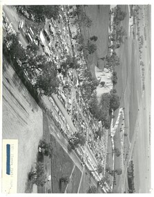 Bendigo Historical Society Inc.
Photograph - ELMORE FIELD DAYS 1970
Elmore Field Days were first held in 1964.Black and white aerial photograph of Elmore Field Days site. Lines of exhibitors and vehicles on site. Anabranch of Campaspe River alongside site. On back of photo :' Robert Wallace Studios, 8 Ruth Street, Golden Square' Elmore Field Days site has been moved to purpose built site nearbye. The site pictured is now a camping reserve.event, agriculture, elmore field days -
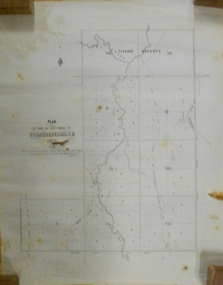 Bendigo Historical Society Inc.
Document - MARKS COLLECTION: STRATHFIELDSAYE PLAN 1854
Plan drawn on light paper. Written on LH side of plan 'Plan of Part of the Parish of Strathfieldsaye 1854. Scale (shown) Lithographed at the Surveyor Generals Office, Melbourne July 10th. By I. Jones'. Plan shows Emu Creek and Village Reserve at top of plan, Shepherd's Creek on RH side, Parish Boundary Line on RH and bottom of plan.map, bendigo, shire of strathfieldsaye 1854