Showing 2296 items matching "1885"
-
 Flagstaff Hill Maritime Museum and Village
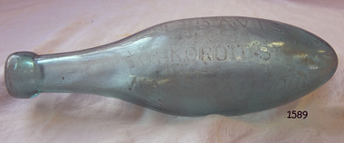
Container - Torpedo Bottle, Last quarter of the 19th century
This bottle has come from the aerated waters factory of John Fletcher of Warrnambool. This factory in Koroit Street was established in the mid 19th century by John Davis. As a young boy John Fletcher worked at the cordial factory of John Rowley in Banyan Street, Warrnambool and then worked for a number of years for John Davis at his Union Cordial Factory. In 1885 John Fletcher succeeded John Davis and continued in this business until 1930. The business was then taken over by Ralph Reeves. John Fletcher manufactured aerated waters, soda, tonic waters, lemonade, ginger ale, hop beer, hop bitters, sarsaparilla and cordials. The bottle would have been sealed with a cork stopper. The torpedo shape of the bottle would ensure that it was stored on its side, keeping the cork moist so that it didn't shrink and cause the bottle to leak its contents.The bottle is significant for its unusual torpedo shape and for being sold by the long standing John Fletcher's soft drink business in Warrnambool who was a prominent soft drinks manufacturer in Warrnambool for over 40 years.Torpedo shaped green glass bottle, name of manufacture of contents, John Fletcher Late and J. Davis, of Koroit St Warrnambool, is impressed in the glass."John Fletcher Late and J. Davis Koroit St Warrnambool"flagstaff hill, warrnambool, shipwrecked-coast, flagstaff-hill, flagstaff-hill-maritime-museum, maritime-museum, shipwreck-coast, flagstaff-hill-maritime-village, torpedo shaped glass bottle, torpedo bottle, bottle, john fletcher late and j. davis koroit st warrnambool, john fletcher late and j. davis, john fletcher late, j. davis -
 Flagstaff Hill Maritime Museum and Village
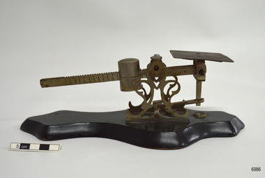
Instrument - Letter Scale, 1920s to 1960s
This scale was owned by Dr Angus, whose training and experience included chemistry and pharmacy. This is a sliding balance scale. The object to be weighed, such as a letter or a dose of medicine, is placed on the square metal plate and the weight, the slider, is moved along the notched metal arm and adjusted until the arm is horizontal, then reading is recorded of the figure the pointer on the slider is positioned. This design of small is often referred to as a letter scale. This item was donated to Flagstaff Hill Maritime Village by the family of Doctor William Roy Angus, Surgeon and Oculist. It is part of the “W.R. Angus Collection” that includes historical medical equipment, surgical instruments and material once belonging to Dr Edward Ryan and Dr Thomas Francis Ryan, (both of Nhill, Victoria) as well as Dr Angus’ own belongings. The Collection’s history spans the medical practices of the two Doctors Ryan, from 1885-1926 plus that of Dr Angus, up until 1969.The scale is significant as an example of 20th century measuring and weighing equipment. It is also important for its association with the W.R. Angus Collection, which is significant for still being located at the site it is connected with, Doctor Angus being the last Port Medical Officer in Warrnambool. The collection of medical instruments and other equipment is culturally significant, being a historical example of medicine, administration, household equipment and clothing from the late 19th to the mid-20th centuries. Dr Angus assisted Dr Tom Ryan, a pioneer in the use of X-rays and in ocular surgery. Scale; a small sliding balance letter scale. The scale has a flat metal platform and a toothed metal balance arm with cylindrical brass weight. These are attached to a decorative metal stand that is mounted onto a shaped lacquered black wooden base. The sliding weight causes the arm to pivot on the stand. The arm is marked into equal-length segments from 0 to 8. Each segment is marked into halves. There is no maker’s mark. The scale is part of the W.R. Angus Collection.flagstaff hill, warrnambool, maritime village, maritime museum, shipwreck coast, great ocean road, dr w r angus, letter scale, postal scale, balance scale, single arm scale, chemist scale, pharmacy scale, office equipment, retail equipment, sales equipment, measuring instrument, weighing instrument, technical instrument, medications, w.r. angus collection -
 Stawell Historical Society Inc
Archive - Books & Papers, Stawell Rifle Club Records Minute books
Rifle Club existed from at least 1880's in Stawell 4271-1 Minute Book 7 May 1885 - 7 June 1899 4272-2 Minute Book 3 May 1907 - 11 October 1910 4272-3 Minute Book 12 July 1915 - 21 March 1921 4272-4 Minute Book 12 March 1917 - 21 January 1947 4272-5 Minute Book 20 May 1947 - 24 March 1960 4272-6 Correspondence Carbon Book 2 August 1957 26 Febuary 1978 4272-7 Minute Book 9 July 1960 - 15 March 1986 4272-8 Minute Book 7 April 1986 - 1 December 2001 4272-9 Minute Book 19 January 2002 - 9 June 2017Series of Ledgers 9 in all.sport -
Stawell Historical Society Inc
Archive - Books & Papers, Stawell Rifle Club Records Minute books
Rifle Club existed from at least 1880's in Stawell 4271-1 Minute Book 7 May 1885 - 7 June 1899 4272-2 Minute Book 3 May 1907 - 11 October 1910 4272-3 Minute Book 12 July 1915 - 21 March 1921 4272-4 Minute Book 12 March 1917 - 21 January 1947 4272-5 Minute Book 20 May 1947 - 24 March 1960 4272-6 Correspondence Carbon Book 2 August 1957 26 Febuary 1978 4272-7 Minute Book 9 July 1960 - 15 March 1986 4272-8 Minute Book 7 April 1986 - 1 December 2001 4272-9 Minute Book 19 January 2002 - 9 June 2017Series of Ledgers 9 in all.sport -
 8th/13th Victorian Mounted Rifles Regimental Collection
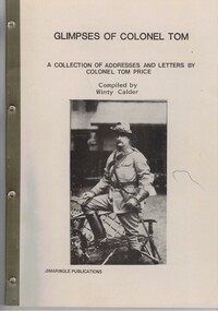
Book, Glimpses of Colonel Tom
This is a supplement to Winty Calder's earlier work 'Heroes and Gentlemen'. Thomas Caradoc Rose Price CB, often known as Colonel Tom Price, was an Australian soldier, and acting commandant of the Commonwealth Military Forces in Victoria in 1902. Joining the British Indian Army in his early years, he served 20 years in India before returning to Australia. In 1885, he raised the Victorian Mounted Rifles, and was instrumental in establishing the concept of light horse units within the Australian Army. In 1900, he led a Victorian contingent during the Second Boer War, and was the only Australian officer during that war to command a force of British regulars. He remained in the Australian military after the war, serving in Queensland until 1904 when he was medically discharged. He retired to Victoria again and died in 1911 at the age of 68.Soft cover book with adhesive binding on spine, A4 size, 56 pages being a collection of addresses and letters of Colonel Tom Price, compiled by Winty Calder, published by Jimaringle Publications 1985. Gift letter on reverso of front cover.Presented to the 8/13 Victorian Mounted Rifles Royal Australian Armoured Corps as a memorial to Colonel Tom Price and the original Victorian Mounted Rifles and as a tribute to the men who carry on a fine tradition. Winty Calder 4 October 1985.price, calder, vmr, victorian mounted rifles -
 Surrey Hills Historical Society Collection
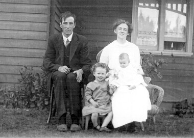
Photograph, Albert and Hazel Crump in 1916 with their daughters Thelma and Joyce
Albert and Hazel Crump at their home ‘Hazeldene’, 1 Leopold Crescent in 1916. ‘Hazeldene’ was opposite the end of Albert Crescent. Albert and Hazel lived here from the time of their marriage in 1913 until 1918 when they moved back to Dandenong. This Federation house is of rather unusual design with verandas on the front corners and the centre room projecting. It was demolished in the 1960s and replaced by units. From 1913-1918 Albert was proprietor of the grocery store in Canterbury Road (next to the present Surrey Lodge). This was owned by Alfred Geer and had opened in 1885 by George Sim. Pictured with their daughters Thelma and Joyce Joyce Kathleen Crump - BIRTH 1916, Surrey Hills; DEATH 16 MAY 1990, Pakenham [Married Thelma Osborne Crump - BIRTH 5 June, 'Hazeldene', Surrey Hills; DEATH 25 JULY 1943, Richmond [Married Reginald Thomas Elvish] Not pictured: Betty Nevill Crump.A sepia coloured photograph of a family group seated outside a house. The baby is seated on the ladies lap.(mrs) hazel crump, (mr) albert crump, (miss) thelma crump, (miss) joyce crump, house names, hazeldene, leopold crescent, surrey hills, federation style, grocer, clothing and dress, 1916, albert henry crump, hazel may crump, hazel may ordish -
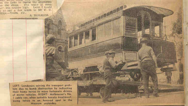 Ballarat Tramway Museum
Newspaper, "Lament and Reverie on Passing of Melbourne's Cable Trams", "Cable Trams .... Clang Into History", 1940
Newspaper clippings contained within Reg. Item 2526, page 11 and 12. Cutting on page 11 titled "Lament and Reverie on Passing of Melbourne's Cable Trams", written "By a Former Traveller", with date of 26-10-1940 in blue pence. Notes that the person was glad not to know of the last run of the Melbourne cable trams, the previous Saturday. Laments their passing, rides, crews, St. Kilda Road, the tramcars and the services provided. At the base of the cutting has a photograph of cable trailer No. 1 being off loaded in Lonsdale St. to go into the Museum. Cutting on page 12, titled "Cable Trams .... Clang Into History" written by Hugh Murphy. Appears to have been written prior to their withdrawal in Melbourne but noting their closure at the end of the year. Notes the construction, the costs, Mr. F.B. Clapp, G. S. Duncan, operations, the various routes, the services and the gradual deterioration of the track. Has the Melbourne Punch cartoon of 10/12/1885, titled "Bail Up". Cuttings have been cut out from a sheet and pasted into the book. Note Item Not formally Numbered.melbourne, tramcars, cable trams, cartoons, tramways -
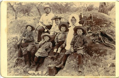 Bendigo Historical Society Inc.
Photograph - Abbott family group, 1895
Richard Hartley Smith Abbott, company director, was born, probably in Bendigo, Victoria, around 1859, the son of Richard Hartley Abbott, also a company director, and Ann, née Smith. The young Richard was educated at Bendigo High School and then at St Andrews, Scotland. Returning to Australia, he became proprietor of the Abbott Supply Company, a director of the Sandhurst Building Society, the Bendigo Gas Company, and several local mining enterprises. He owned farms at Lyell, Mandurang and Eppalock, and was a pioneer of lucerne cultivation and tanning. In 1887, Abbott became a councillor for Strathfieldsaye Shire, a position he held for fifteen years. He was shire president (1901–02) and a Bendigo City councillor (1904–09; 1913–19), serving as Mayor of Bendigo between 1917 and 1918. Richard died in 1940. https://biography.senate.gov.au/richard-hartley-smith-abbott/ 'Preston Vale' was a property in Sedgewick. A sepia photo taken at Preston Vale of the Abbott family in 1895 including Richard Hartley Smith Abbott (Snr.) Mary Hannah (Gibbs) Abbott and their five oldest children, Richard Hartley Abbott born 1885, Inez Marie Abbott born 1886, William Norman Abbott born 1888, Harold Athelstone Abbott born 1889, and Kenneth Cyril Abbott born 1890. Two of the boys are wearing long sleeved striped collared shirts, one a scouting style coat and the youngest a collared shirt and all boys are in short pants with socks or stockings. Inez, is in a long sleeved dress with white smock with white bonnet. She is wearing boots. All others are wearing hats, Mrs Abbott's hat has a scrunched/folded ribbon on the brim. She is wearing a long sleeved light coloured blouse fastened at the neck The group is seated on an outcrop of granite rocks with parts of a buggy and horse tackle showing behind them. A lidded billy and scattered cups are on the ground in front. Mr Abbott, in shirt and long pants, is carrying a shot gun as is one of the boys. Both photos have 'Preston Vale Dec 26/95' written in ink on the reverse.abbott family, preston vale -
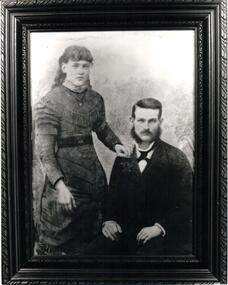 Hume City Civic Collection
Photograph
A portrait of a couple with the female standing and the male seated identified as Elizabeth and John Wilson. A b/w photo.Handwritten on back: PHOTO OF ELIZABETH AND JOHN ANDREW WILSON / b 1862 Sunbury bn 2 May 1861 Ballan, Vic / married 10th April 1882 SUNBURY / d 19 OCT 1937 Coburg d 17 AUG 1898 MELB HOSP. BURIED MELBOURNE GEN. CEMETERY / (Elizabeth) BURIED FAWKER CEMETERY / THEIR CHILDREN WILLIAM JOHN ANDREW WILSON B 1883 ELIZABETH FLORENCE SELINA WILSON B 1885 SUNBURY MAUD EDITH WILSON B 1887 SARAH MABEL LOUISE WILSON B 1890 ELIZABETH'S PARENTS WERE: WILLIAM JOSEPH DONELLY AND ELIZABETH nee CLARK married 1852 BRAMPTON, ENGLANDwilson, elizabeth (mrs), john andrew, weddings, sunbury, william john, elizabeth florence selina, maud edith, sarah mabel louise, donelly, william joseph, clark, elizabeth (miss), andrew, mcdaid, sarah (miss), sarah (mrs), george evans collection -
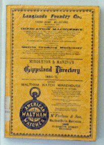 Orbost & District Historical Society
book, E-Gee Printers, Middleton & Manning's Gippsland Directory 1884-5, 1983
The 1884-1885 Directory was the first year of publication for the Middleton and Manning's Gippsland Directory. It was first published by Ale Middleton and Francis Beresford Manning. Beginning with advertisements from local businesses of the time, this is followed by a short gazetteer of places around the region, as well as general information on the districts of Gippsland. The main part of the Directory consisting of about 100 pages, is the Alphabetical Directory. Listed alphabetically by surname under each region, this lists heads of household (mostly male but there are a few females mentioned), together with their occupation and address.The list includes farmers, labourers, coach painters, dairywoman, teacher, saddler, brickmaker, merchant, laundress, hotel keeper, minister of religion, dressmaker, grocer, grazier, gasfitter, seedsman, coachbuilder, engineer, auctioneer, upholsterer, fowler, journalist, surveyor, musician, traveller, watchmaker, solicitor, restaurant keeper, blacksmith and miner. It is not just "business owners" mentioned in this directory it is everyone. (ref Gen E Books)This is a useful reference tool.A 135 pp soft covered book with an orange/brown cover. On the front cover in black print is a range of advertisements or local businesses. It contains a short gazetteer of places in the region as well as general information on the districts of Gippsland. The main part of the directory is an alphabetical list of the household , with occupations and addresses. This is a reprint of the original.directory-gippsland book-middleton-manning-1884-5 -
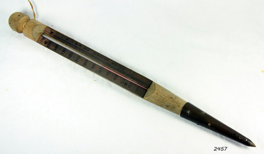 Flagstaff Hill Maritime Museum and Village
Confectionery Thermometer, Early 20th Century
The company was established in 1859 by Alfred Charles Cossor following a period of apprenticeship by the founder as a glass blower, Having gained a high reputation for his skills and the quality of his products, the founder was joined by his sons Alfred Charles in 1875 and then by his younger son Frank in 1885. In 1904 Accoson produced their first glass manometer, using their glass blowing skills, known as the sphygmomanometer. A year later Russian surgeon Nikolai Korotkoff first described the technique to measure diastolic pressure. In 1921 Frank Cossor was joined by his son Frank Gordon Cossor and the company expanded its products to include all types of thermometers, hydrometers and syringes. However, Sphygmomanometers became the main product of the company. When Adrian Cossor joined the company in 1966 he was the fourth generation to do so. Accoson was acquired by the HCE Medical Group in 2018 and relocated to new premises in Irvine, Scotland. An item made for the confectionery industries not very rare, but made by the company that invented and pioneered the blood pressure meter (sphygmomanometer) that is still in use today and an item we all have use when we have visited our doctor when our blood pressure is checked.Thermometer wooden casing with a metal tip. used for measuring temperature by the expansion and contraction of mercury or alcohol in a capillary tube and bulb. Inscription Made by ACCOSON, in England for B.M.I. Ltd.flagstaff hill, warrnambool, shipwrecked-coast, flagstaff-hill, flagstaff-hill-maritime-museum, maritime-museum, shipwreck-coast, flagstaff-hill-maritime-village, thermometer, b.m.i. ltd, accoson, blood pressure -
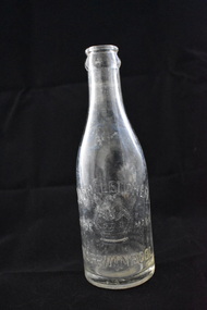
Warrnambool and District Historical Society Inc.
Functional object - Ginger Ale Bottle, John Fletcher. Koroit Street, Warrnambool, c. 1930
This bottle was found in sea water while the donor was snorkelling in Stingray Bay, Warrnambool. It is a marble stopper bottle from the Warrnambool cordial factory of John Fletcher. Th bottle was filled upside down so that as soon as the filling ceased the marble was forced down to seal the bottle against a rubber ring (missing in this bottle). Pressure inside the bottle would keep the marble pressed against the top of the neck. To open the bottle the marble was pressed down so that it fell into the body of the bottle. John Fletcher as a young boy worked at Rowley's Cordial Factory in Banyan Street, Warrnambool. He then worked for John Davis who had established the Union Cordial Factory in Koroit Street in the 1860s. In 1885 John Fletcher bought Davis' business and operated it until 1930. It was then bought by Ralph Reeves. John Fletcher manufactured soda water, lemonade, tonic waters, ginger ale, sarsaparilla, cordials, hop beer and hop bitters.This bottle is of some interest as an example of a marble stopper bottle over 90 years old and as a memento of the Warrnambool soft drinks business of John Fletcher, a prominent businessman in Warrnambool for over 40 years.This is a clear glass bottle with a rounded body, a heavy indentation near the base of the neck and a thick tapering neck with a round opening. The bottle contains a green marble and some marine detritus. The bottle is discoloured with stains and dirt and has lettering etched into the side and base.John Fletcher Ginger Ale Warrnambool This bottle is the property of John Fletcher Warrnambool and cannot be legally used by others Gjohn fletcher warrnambool, cordial manufacturers in warrnambool -
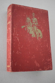 Warrnambool and District Historical Society Inc.
Book, Hodder and Staughton, Corporal Campion, 1912
This book belonged to Robert Giles. He obtained it in 1914 and the bookseller was Mrs Tilly Rowan who was a well-known businesswoman in Warrnambool with a book shop and newsagency in the Oddfellows Hall in Koroit Street. Robert Giles (1895-1967) was born in Wangoom and went to the Wangoom State School and the Warrnambool Agricultural High School. He served in World War One and worked at the State Savings Bank in Warrnambool from 1911 to 1921 (excluding war service). He later worked in banks in Koroit, other Victorian country districts and Melbourne and retired to Mailors Flat. He was married to Vera King and they had one child, Joyce Aurelin. A Warrnambool branch of the Savings Bank was opened in Warrnambool in 1859 and it moved into a new building in Timor Street in 1885. (This building in now part of the Archie Graham Senior Citizens’ Centre). The State Savings Bank became the State Bank of Victoria in 1980 and in 1990 was subsumed into the Commonwealth Bank of Australia. This book is retained because it belonged to Robert Giles who lived in the Warrnambool area for part of his life and who worked at the State Savings Bank in Warrnambool early in the 20th century. This is a hard cover book of 408 pages. The cover is red with a gold-coloured image of a horse and a mounted policeman on the front cover and gold printing on the spine. The book has 25 chapters of text. Two labels of the book’s seller are affixed to the front cover and a title page. The cover is much scuffed.‘July 9th 1914 Robert P. Giles State Savings Bank Warrnambool’giles family, warrnambool, state savings bank warrnambool, history of warrnambool -
 Warrnambool and District Historical Society Inc.
Bottle, Fletts Soda Water Warrnambool
This is a marble stopper bottle that came from the Warrnambool aerated waters factory of John Fletcher. This bottle was filled upside down so that as soon as the filling stopped the marble was forced down to seal the bottle against the rubber ring. Pressure inside the bottle would keep the marble pressed against the top of the bottle. To open the bottle the marble was pressed down where it has fallen into the neck chamber below. The marble stayed inside the bottle when it was tilted for drinking. John Fletcher worked as a young boy at Rowley’s cordial factory in Banyan Street Warrnambool. He then worked for John Davis who had established the Union Cordial Factory in Koroit Street in the 1860s. In 1885 Fletcher bought John Davis’ business and operated it until 1930. It was then bought by Ralph Reeves. John Fletcher manufactured soda water, tonic waters, lemonade, ginger ale, sarsaparilla, cordials, hop beer and hop bitters. This bottle is of some significance as an example of a marble stopper bottle and as a memento of the Warrnambool soft drinks business of John Fletcher. He was a prominent businessman in This is a mauve-coloured glass bottle known as a marble stopper bottle. The base and body are round with the top part of the body heavily indented to form a narrow opening leading to the neck. The neck is rounded and slightly tapering to the moulded round top. A green glass marble is loose in the neck section. The rubber ring at the top of the opening is missing. The details of the soda water manufacturer are embedded into the glass on the sides. ‘John Fletcher Trade Mark (crown symbol) Warrnambool’ ‘Soda Water’ ‘M’ john fletcher, warrnambool, cordial manufacturers in warrnambool, history of warrnambool -
 Eltham District Historical Society Inc
Photograph, A.W. Burman, Possibly Catherine Shillinglaw, c.1878
Catherine Shillinglaw was born November 13, 1852 at Coburg, Victoria. In 1897 she married Edward Henry Bottle (1854-1900). Catherine died April 7, 1934 at Northcote, Victoria. A.W. Burman, Artist Photographer, 209 Bourke Street East, Melbourne According to Sands & McDougall Melbourne Directory, Arthur W. Burman was active 209 Bourke St East, Melbourne from 1878 to circa 1885-1890 CARTE-DE-VISITE (cdv) 1857-1890 Cartes-de-visite (cdv's) are the most common form of photograph from the nineteenth century, generally measuring two and a half inches by four and an eighth inches (6.3 x 10.5 cm) when mounted, sepia toned, mounted on a card which was generally printed with the photographer's name and address on the back or beneath the portrait. - Frost, Lenore; Dating Family Photos 1850-1920; Valiant Press Pty. Ltd., Berwick, Victoria 1991a.w. burman photographer 209 bourke st east, marg ball collection, shillinglaw family photo album 1, 1878, 1878-1885, catherine bottle (nee shillinglaw 1852-1934), unknown -
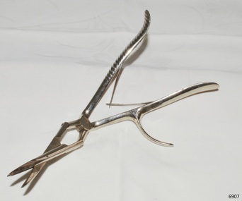 Flagstaff Hill Maritime Museum and Village
Instrument - Surgical Instrument, early 20th century
This surgical instrument, known as a nasal septum, was donated to Flagstaff Hill Maritime Village by the family of Doctor William Roy Angus, Surgeon and Oculist. It is part of the “W.R. Angus Collection” that includes historical medical equipment, surgical instruments and material once belonging to Dr Edward Ryan and Dr Thomas Francis Ryan, (both of Nhill, Victoria) as well as Dr Angus’ own belongings. The Collection’s history spans the medical practices of the two Doctors Ryan, from 1885-1926 plus that of Dr Angus, up until 1969. Dr Angus and his family moved to Warrnambool in 1939 and purchased 'Birdwood in Koroit Street (now the location of the Police Station and ALDI), the previous home and medical practice of Dr John Henderson. Dr Angus was appointed on a part-time base as the Port Medical Officer in Warrnambool and held this position until the 1940s, when the position was no longer required. He was also a surgeon at the Warrnambool Base Hospital 1939-1942.This surgical instrument is significant for its connection with Dr W.R. Angus of Warrnambool. The W.R. Angus Collection is significant for still being located at the site it is connected with, Doctor Angus being the last Port Medical Officer in Warrnambool. The collection of medical instruments and other equipment is culturally significant, being an historical example of medicine, administration, household equipment and clothing from late 19th to mid-20th century. Dr Angus assisted Dr Tom Ryan, a pioneer in the use of X-rays and in ocular surgery. Surgical instrument, part of the W.R. Angus Collection. E.N.T. nasal snare or nasal septum, forceps, stainless steel, scissor action, spoon shaped blades. One handle is textured, other has finger hook on side. Made by Matrick of London.Stamped inscriptions "MATRICK" and "30" is stamped 4 times on instrumentflagstaff hill, warrnambool, flagstaff hill maritime museum, maritime museum, shipwreck coast, flagstaff hill maritime village, great ocean road, dr w r angus, surgical instrument, warrnambool base hospital, medical treatment, medical history, nasal septum, forceps, matrick, london, william roy angus, port medical officer, birdwood, e.n.t., nasal snare -
 Orbost & District Historical Society
minute book, 24.8.1884 - 19.11.1926
A Mechanics’ Institute hall was constructed in 1885 and opened as Orbost's first library. It was situated in Browning Street, Orbost. The hall is still in use today as a community venue. Mechanics' Institutes are the forerunners of public libraries and adult education in Australia. The origin of mechanics' institutes is attributed to Dr George Birkbeck, who in 1799 gave a series of free lectures for the working men of Glasgow. At the time, 'mechanic' meant artisan, tradesman or working man. The movement spread quickly throughout the British Empire. The first Victorian Mechanics' Institute was the Melbourne Mechanics' Institute established in 1839. From the 1850s, Mechanics' Institutes quickly spread throughout Victoria wherever a hall or library, or a school was needed. This ledger was used by the Orbost Mechanics' Institute from 1884 until 1926. The item was donated to Orbost & District Historical society from P.R.O.V. as a Place of Deposit (POD) item for safe keeping by a local history group or museum.The Mechanics' Institute was a very early feature of the Orbost community. The building became a community facility used for a variety of essential civic needs in particular a library. It also provided a suitable venue for community social requirements and functions.A heavy minute book with faded black covers and brown binding. The edges of the pages are marbled as are the end covers. Pages inside are blue with hand-written black ink records. It contains minutes from the Orbost Mechanics Institute.on spine on red leather in gold lettering: "MINUTE BOOK"minute-book orbost-mechanics'-institute -
 Flagstaff Hill Maritime Museum and Village
Artwork, other - A religious print and almanac, Australasian Church of Christ, 1892
This religious almanac with biblical imagery listed the Churches of Christ in Australasia and scripture readings for a calendar year of 1892. The almanac was produced and updated annually to reflect current information. The Churches of Christ in Australia is a Reformed Restorationist denomination. Congregations in South Australia, Victoria and New South Wales were established by individuals who travelled to these colonies to pursue employment opportunities, elsewhere in Australia Churches of Christ congregations were established as missionary initiatives. Churches of Christ in Victoria began with the arrival of the Ingram and Picton families from England who established regular meetings in Prahran and officially constituted a congregation in 1855. In Warrnambool plans were drawn up in 1883 for the erection of a Church of Christ at 12 Spence Street. The church was opened in 1885 with visiting pastors until a resident minister, A. J. Fisher, was appointed in 1915. This church was closed early in the 21st century when a new church, Gateway Church of Christ, was opened in Ragland Parade in Warrnambool. A rare survival of social and spiritual ephemera related to the Christian worship throughout Australia during the late nineteenth century. Portrait of a religious female figure wearing a simple dress with a crucifix around her neck. On the rear of the frame is an 1892 Australasian Church of Christ Almanac for suggested scripture readings. One of a pair.flagstaff hill, warrnambool, maritime museum, 1892, almanac, scripture readings, australiasian church of christ, church, religion, christianity -
 Flagstaff Hill Maritime Museum and Village
Artwork, other - A religious print and almanac, Australasian Church of Christ, 1892
This religious almanac with biblical imagery listed the Churches of Christ in Australasia and scripture readings for a calendar year of 1892. The almanac was produced and updated annually to reflect current information. The Churches of Christ in Australia is a Reformed Restorationist denomination. Congregations in South Australia, Victoria and New South Wales were established by individuals who travelled to these colonies to pursue employment opportunities, elsewhere in Australia Churches of Christ congregations were established as missionary initiatives. Churches of Christ in Victoria began with the arrival of the Ingram and Picton families from England who established regular meetings in Prahran and officially constituted a congregation in 1855. In Warrnambool plans were drawn up in 1883 for the erection of a Church of Christ at 12 Spence Street. The church was opened in 1885 with visiting pastors until a resident minister, A. J. Fisher, was appointed in 1915. This church was closed early in the 21st century when a new church, Gateway Church of Christ, was opened in Ragland Parade in Warrnambool. A rare survival of social and spiritual ephemera related to the Christian worship throughout Australia during the late nineteenth century. Portrait of a religious female figure wearing a naval type of coat and pendent around her neck. On the rear of the frame is an 1892 Australasian Church of Christ Almanac for suggested scripture readings. One of a pair.flagstaff hill, warrnambool, maritime museum, 1892, almanac, scripture readings, australiasian church of christ, church, religion, christianity -
 8th/13th Victorian Mounted Rifles Regimental Collection
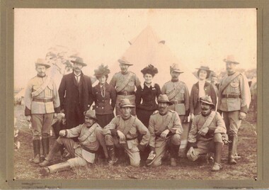
Photograph - VMR c.1900
The Victorian Mounted Rifles was raised as the mounted arm of the Victorian Colonial defence force in 1885. It was under the command of Colonel Thomas Caradoc Rose (Tom) Price (1842-1911). Price was born in Tasmania, educated in Hobart Town and at Scotch College, Melbourne, before entering the East India Military College, Addiscombe, England. He was commissioned on 7 July 1861 in the Madras Infantry and began twenty years’ service in India with several regiments, retiring in April 1883. On his return to Victoria he was tasked with raising of a force of one thousand, to be known as the Victorian Mounted Rifles, and appointed a lieutenant-colonel in the Permanent Military Forces. Companies of the Victorian Mounted Rifles were raised in rural districts throughout Victoria. The soldiers were paid a small annual allowance and were required to provide their own horse. Many members served in contingent to the Boer War. After Federation the VMR was gathered up into the Australian Light Horse. Black and white photograph of group of Victorian Mounted Rifles soldiers posed with a gentleman and three ladies. Occasion is probably open day at a camp of training. Photograph is professionally mounted o backing card.Ink stamp on reverse: "Hewitt / Photographer / 98 Simpson Street east Melbourne / Weddings and picnics attended / Extra copies may be obtained"vmr, boer war, colonial, training, uniform -
8th/13th Victorian Mounted Rifles Regimental Collection
Document - History VMR South Africa
The Victorian Mounted Rifles was raised as the mounted arm of the Victorian Colonial defence force in 1885. It was under the command of Colonel Thomas Caradoc Rose (Tom) Price (1842-1911). Price was born in Tasmania, educated in Hobart Town and at Scotch College, Melbourne, before entering the East India Military College, Addiscombe, England. He was commissioned on 7 July 1861 in the Madras Infantry and began twenty years’ service in India with several regiments, retiring in April 1883. On his return to Victoria he was tasked with raising of a force of one thousand, to be known as the Victorian Mounted Rifles, and appointed a lieutenant-colonel in the Permanent Military Forces. Companies of the Victorian Mounted Rifles were raised in rural districts throughout Victoria. The soldiers were paid a small annual allowance and were required to provide their own horse. Many members served in contingents to the Boer War. After Federation the VMR was gathered up into the Australian Light Horse. Photocopy of a single page typed document relating to the Victorian Mounted Rifles in South Africa 1899-1902.light horse, vmr, south africa, boer war, history -
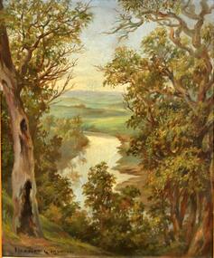 Kew Historical Society Inc
Painting, Herbert J Woodhouse, River Yarra Near Dights Falls, c.1892
Herbert James Woodhouse (1854-1937) was born in Essex and arrived in Australia with his family in 1857. A painter-lithographer like his father and three of his brothers, he was a prizewinner in the South Australian Society of Arts exhibition of 1885. He also received commendations in exhibitions at the Victorian Academy of Arts and the New South Wales Arts Society. At an exhibition of his paintings at Scott’s Hotel in Collins Street in 1892, the reviewer for Table Talk noted that the ‘artist paints almost solely in the open air, and his studies are generally carried out during the trips of the Victorian Sketching Club’. One of the paintings singled out for praise was: ‘A very effective river scene at Willsmere, aptly named A Midstream Mirror, ... a picture powerful in its effective reflection of sunlight in the river.’ Herbert Woodhouse died in Geelong in June 1937, aged 82, and was buried in the Eastern Cemetery. A number of his sketchbooks are held in the collection of the State Library of Victoria.Framed oil painting on board of the River Yarra at Studley Park, Kew, by Herbert James Woodhouse (1858-1937). The artist has framed the narrow painting with trees in the foreground and a view of the Yarra River and rolling hills in the background. Verso, written by artist: "River Yarra Near Dights Falls"australian art - 19th century, herbert james woodhouse (1854-1937), yarra river - studley park -
 Kew Historical Society Inc
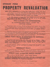
Document, Studley Park Property Revaluation
A search of the Dictionary of Biography returned the names of thirty-two individuals with a connection to Kew, who were claimed to be supporters, members or opponents of the Communist Party of Australia. Some were only linked to communism by reputation. The historian, Geoffrey Serle, in the entry on Vance Palmer (1885-1959) wrote that: ‘From 1942 he was a member of the Commonwealth Literary Fund's advisory committee and from 1947 to 1953 chairman; he suffered despicable allegations that he was a communist’ (Serle, 1988). Serle also noted that Palmer, a liberal socialist of the broad left, was defended by R.G. Menzies. Others were linked through marriage. Gwendolyn Kent Hughes (1889-1965), the third daughter of Wilfred Kent Hughes, was married to Victor Reginald Lloyd (1895-1964) in 1930 in Holy Trinity Church. Lloyd ‘... had strong ties to the trade union movement and belonged to the Communist Party of Australia’ (Barbara Falk, 2000).Single page flyer used in a City of Kew election for Studley Ward protesting about Rate Increases in the Ward. The Society has only one item of this communist legacy in its files. It is an undated electoral tract, appropriately printed on red paper, advising electors in a local government election to vote against rate rises in Studley Ward. communist party of australia -- kew (vic.), political flyers -- kew (vic.)