Showing 54659 items
matching documents-maps
-
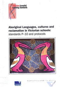 Victorian Aboriginal Corporation for Languages
Book, Victorian Curriculum and Assessment Authority, Aboriginal languages, cultures and reclamation in Victorian schools : standards P-10 and protocols, 2009
maps, diagramseducation, language revival, bilingual education -
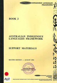 Victorian Aboriginal Corporation for Languages
Book, Australian Indigenous Languages Framework Project, Australian Indigenous languages framework support materials, 1994
maps, tableskaurna, education, bilingual education, lote, languages other than english, language revival, aboriginal english, language ecology -
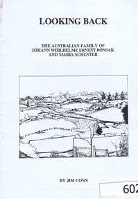 Greensborough Historical Society
Genealogical document, Jim Conn, Looking Back, 1985_
Jim Conn compiled this document from his family history research. The Bonsak family has many descendants in the Greensborough district.A 42 page black and white document outling the family history of the Bonsak family.The original owner's name is written in black biro on the inside front cover.bonsak, bonsack, schuster, conn, greensborough, orbost -
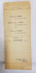 Numurkah & District Historical Society
Legal Document - Articles of Apprenticeship
Henry Pearson was a dentist in Numurkah between 1911 and 1929 (referenced in Bossence book) This document is an agreement between Pearson and Leonard Bennett (son of Ernest Bennett, Hairdresser, who was the witness to this document). the agreement was that Pearson would take on Leonard as an apprentice in profession of Mechanical Dentist. The documents then goes on to outline what was involved in the apprenticeship: days, hours, bord, Yellowed legal document outlining Articles of Apprenticeship, dated 16th January, 1915. Names of people involved on the front. When opened up, the document outlines the what's involved in the apprenticeship, and includes signatures of the people involved. Solicitors were Morrissy & Deane, Numurkahsee photos abovesolicitors, morrissy & deane, apprenticeship, legal documents, indenture -
 Whitehorse Historical Society Inc.
Document, F. S. Baker/ Yarra Hill country map, 1950s
Advertising leaflet for F. S. Baker, Mt. Pleasant Road Nunawading,Advertising leaflet for F. S. Baker, Mt. Pleasant Road Nunawading, Real Estate Agent c. 1950s, backed by Broadbent's Map no. 280, Yarra Hill CountryAdvertising leaflet for F. S. Baker, Mt. Pleasant Road Nunawading, broadbents, baker, f. s., mount pleasant road, nunawading, no. 20 -
 Warrnambool and District Historical Society Inc.
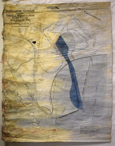
Map - Map of Proposed Alterations to Warrnambool Harbour 1925, Warrnambool Harbour Committee, Warrnambool Harbour Proposed Wharves and Basin in Lake Pertobe with Eastern Wall, 1925
This map was printed in 1925 and contains the Warrnambool Harbour alterations proposed by the Warrnambool Harbour Committee incorporating the original designs of Captain Menzies, the Warrnambool Harbour Master and the City Engineer, Mr A. Lavercombe. The main features of the proposal were the extension of the Eastern Wall to almost enclose the harbour and a basin in Lake Pertobe. The design was to be placed before the Victorian Royal Commission on the Outer Ports which was established partly to examine the allegations of unsatisfactory work carried out in Warrnambool when the Breakwater was extended 300 feet in 1914 and also to make recommendations regarding all regional ports. The Warrnambool Breakwater was completed in 1890 but failed to provide the shipping conditions needed to continue Warrnambool as a viable port. Many plans and proposals for port improvement such as this one were produced in the late 19th century and the first half of the 20th century with the port officially closed in the 1940s. Still today the Breakwater and Warrnambool Harbour conditions remain a source of contention.This map is significant as it shows a 1925 design for Warrnambool Harbour hitherto little-known. It also has markings showing land sites of the time (BayView Hotel, Woollen Mill etc.)This is a map made of thick yellow paper pasted onto a cloth backing. It has two cloth tags at the top for tying up the map when folded. It appears to be a hand-drawn map copied with printed material added. The map is shaded green and red in some areas. Attached by nails to the map are wooden frames, rounded at the bottom and partly curved at the top. The map is torn and partly detached at the top. The top frame has a cord attached for hanging the map.warrnambool harbour, captain menzies, a.lavercombe city engineer, warrnambool breakwater, royal commission on outer ports -
 Wangaratta RSL Sub Branch
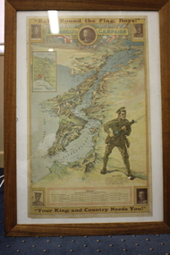
Framed Poster
Map of the Dardanelles Strait, Turkey, used as a World War I recruiting poster Includes photographs of King George V; Major-General Sir W.T. Bridges; Brigadier General G.D. Legge; General Sir Ian Hamilton; and Lieut-General Sir William Birdwood and list of Australian Commonwealth Brigade CommandersPosters were used for various government propaganda campaigns over the course of World War I, most significantly to encourage enlistment, but also to raise money for war charities, to encourage saving and frugality and to rally the home front.Timber framed poster of map of Dardanelle Peninsula featuring soldier holding rifleIn top margin: "Rally round the flag, boys!" In lower margin: "Your King and country needs you!" ww1, recruiting poster -
 Bendigo Historical Society Inc.
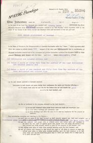
Document - MCCOLL, RANKIN AND STANISTREET COLLECTION: GOLD MINING LEASE CROWN LAND, 1937
Document : McColl, Rankin and Stanistreet: gold mining lease crown land 10916 Bendigo. Foolscap size document, includes map County of Bendigo, Parish of Mandurang. Dated 1937 between King George VI and John Jepson Stanistreet.person, mining, john jepson stanistreet, mccoll, rankin and stanistreet: bendigo, mining, goldmining, john stanistreet -
 Eltham District Historical Society Inc
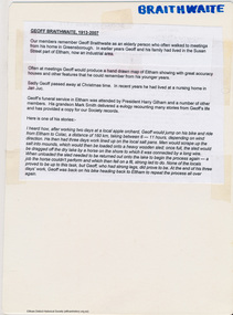
Map, Geoff Braithwaite, Braithwaite ma0p of Eltham circa 1920
A3 photocopy of hand drawn map of Eltham created by Geoff Braithwaite (1914-2008) of his memory of the township about 1920. It includes names of streets and property owners. Folder of information on Geoff Braithwaite Includes A3 photocopy of hand drawn map of Eltham with coloured shading of Eltham in 1920s and 1930sharry gilham collection, eltham, 1920, geoff braithwaite, map, smart family cottage, eltham cemetery, flora caroline braithwaite (nee gamble), geoffrey braithwaite -
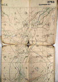 Bendigo Military Museum
Map - TRENCH MAP WW1, 1918
Areas covered on this map, “Coisy, Allonville, Busy, Franvillers” Item re William Alexander No 502 AIF. Refer Cat No 3746.3 for his service details.Trench map, France, Edition 2A, sheet 62D N.W, scale 1:20,000, trenches corrected to 7.5.1918, British trenches in blue.On outside drawn in purple “62D N.W 1:20,000”map, france, trench -
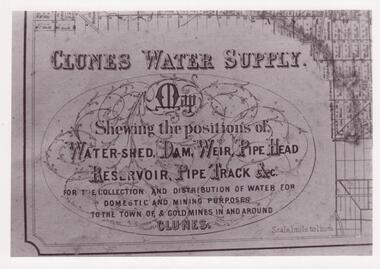 Clunes Museum
Photograph
CLUNES WATER SHED SUPPLY MAP SHEWING THE POSITION OF WATERSHED ECT. FOR THE COLLECTION AND DISTRIBUTION OF WATER FOR DOMESTIC AND MINING PURPOSES TO THE TOWN OF & GOLDMINES IN AND AROUND CLUNES.PHOTOCOPY SECTION OF PHOTOGRAPH AND PLAQUE AND MAP OF CLUNES WATER SUPPLY. SHOWING THE POSITION OF WATERSHED, DAM, WEIR PIPEHEAD RESERVOIR PIPE TRACK.SEE PHOTOGRAPH ON BACK OF HISTORY OF OBJECT.local history, photographs, water supply -
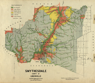 Federation University Historical Collection
Map, Smythesdale, County of Grenville, 1888, 1889
The map maker, Ferdinand M. Krause, was a professor at the Ballarat School of Mines. This land was printed form the Crown Lands Department, Melbourne. Coloured map of the County of Grenville. The edge has been taped. The scale is 40 chains to 1 inch. The map is accompanied with a foolscap sheet printed by the Mines Department in 1898. It is a Report on the Parish of Smythesdale by F.M. Krause and includes information on the water reserve, worked quartz veins, Watson's Hill, Surface Hill and Sugarloaf Hill, Haddon, Trunk Lead and the Crucible Shaft. smythesdale, krause, f.m. krause, ferdinand krause, nitingbool, watson's hill, surface hill, sugarloaf hill, haddon -
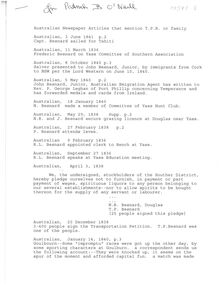 Bendigo Historical Society Inc.
Document - T.P Besnard Research Document
Research documents Besnard Family - Australian Newspaper ArticlesA4 15 page document titled Australian Newspaper Articles that mention T.P.B or familyFor Patrick B O'Neil written in biro on front paget.p besnard, besnard, besnard family tree -
Marysville & District Historical Society
Document (Item) - Information document, Victorian Bushfire Reconstruction and Recovery Authority, Marysville - Murchison Street and Town Amenity Project, 2010
A document outlining the re-building and re-development of Murchison Street in Marysville in Victoria.A document outlining the re-building and re-development of Murchison Street in Marysville in Victoria.marysville, victoria, 2009 black saturday bushfires, murchison street -
Marysville & District Historical Society
Document (Item) - Research document, Judith Vimpani, CARLISLE GUESTHOUSE and the CONEYS, 2018
A document outlining the history of the Carlisle Guesthouse and the Coneys, who owned and operated the guesthouse.A document outlining the history of the Carlisle Guesthouse and the Coneys, who owned and operated the guesthouse.marysville, victoria, australia, carlisle guesthouse, henry coney, mary ann coney, william henry kirwan, harold james robert coney, mr and mrs boyle, phelps, martin cussen, bridget cussen, bridget kirwan, james richard coney, vi marty, blue hills riding school -
 Greensborough Historical Society
Genealogical Document, Jolley Family descendants, 1865o
Parts of a longer document on the Jolley family, these pages connect the family to the Greensborough area.3 pages. Part of a longer document. This copy contains pages 6 to 8.jolley family -
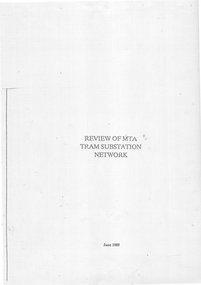 Melbourne Tram Museum
Document, "Review of MTA Tram substation Network", 6/1989
A document dated June 1989 examines the then MTA tram substation network and its issues at the time, in particular the reliability of the aging rotary converters and mercury arc rectifiers. It also considers the need to upgrade the network, increase the power supply for B-class trams, and reduce voltage drop.Yields information about the status of the tram substation and electrical equipment in 1989Photocopy of a 38 page A4 document.tramways, substations, mta, the met, power supply, electrical engineering, rotary converters, mercury arc -
Melbourne Tram Museum
Document, Yarra Trams, "Notice to drivers" - bang road
Document issued by Kew Depot, titled "Notice to drivers" regarding driving on the wrong track (Bang Road) or from the rear end (reversing) not being permitted. Bang Road operation had to be supervised. Dated 1/6/2009, signed by Mario Taccone Depot Manager Kew.Demonstrates an instruction to crew re tram operations.Document - 1 A4 printed sheet yarra trams, trawmays, bang road, instructions, notices, kew depot -
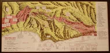 Lara RSL Sub Branch
Photograph, Gallipoli Map Anzac Battlefield 1915
This map shows where the first battalions landed at Gallipoli (April 25) Position of ANZAC battalions when the Turks attacked across the whole front and lost 10,000 dead and wounded (19 May) ANZAC evacuation (20th Dec 1915)Detailed map showing historical sights and battlefields with an information listGallipoli Map Anzac battlefield 1915,Rectangular in shape glass covered picture frame with a wooden boarder.Gallipoli 1915 Anzac Battlefieldphotograph., gallipoli., 1915, anzac, world war one, ww1, battlefield -
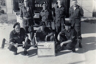 8th/13th Victorian Mounted Rifles Regimental Collection
Photograph - Hartung & section
A map board was standard equipment for every crew commander. It was a plywood base to which map was placed and covered with a sheet of plastic, all secured with bulldog clips. Chinograph pencil was used to mark map.Black and white photograph of seven 8/13 Victorian Mounted Rifles soldiers at Buna Barracks Albury. c1964. Map board control.Lance Corporal Roberts holds improvised pointer. " front: L/Cpl Roberts, Lou Madjeric, Peter Hartung, Rear: Bill Cameron, Jack Harris, John Doyle, Peter McClosky".hartung, roberts, harris, doyle, mcclusky, madjeric, cameron, vmr, buna barracks, albury, military -
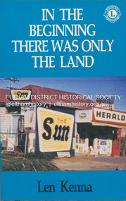 Eltham District Historical Society Inc
Book, Len Kenna, In the beginning there was only the land, 1988
A book, published as part of the Australian Bicentenary Celebrations on the history of the suburb of Bundoora. ... Includes photographs, maps and index. Local history of the outer Melbourne suburb of Bundoora, from the original Wurundjeri people through to its development as a thriving suburb in the 1980s ; section entitled "The Aborigines" (pp.14-21) discusses the traditional way of life of the Wurundjeri people prior to European settlement.bundoora, bundoora hall, hospitals, jane mckimmie, janefield, janefield church, john mckimmie, la trobe university, marvellous melbourne, mont park, mont park psychiatric hospital, plenty river, william shillinglaw, wurundjeri, yan yean reservoir -
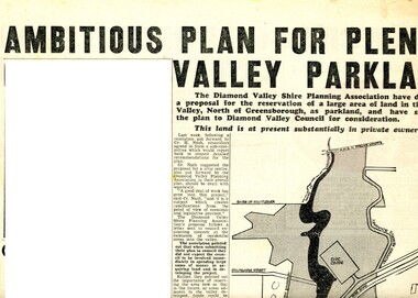 Greensborough Historical Society
Newspaper Clipping - Digital Image, Ambitious plan for Plenty Valley Parklands 1965, 05/11/1965
In 1965, the Diamond Valley Shire planning association recommended to Council that a large area of land north of Greensborough be acquired for Parkland. The idea of a Civic Centre was included with a map of the area from Grimshaw Street in the south to the MMBW pipeline reserve in the north. Includes a suggested new site for the local school, near Yando Street. This area is now part of the Plenty River Trail.An example of developments in the Greensborough area during the period of Shire of Diamond ValleyNews clipping, black and white text and map. Scanned in 3 parts.shire of diamond valley, civic drive greensborough, yando street greensborough, partingtons flat, plenty river trail -
 Bendigo Military Museum
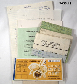
Document - PNG PAPERS, HERDMAN, Ansett - ANA et al, 1964- 1969
Collection of documents related to K.J. Herdman's visit to PNG as part of CMF Officer's visit, 2nd Dec to 13th Dec 1968. Part of the "Kevin John Herdman" No. 397661 Collection. See Catalogue No. 5942P for details of his service. 2. Notes related to Herdman's visit to PNG. List of personnel on visit. 4. Patrol ration pack details. 5. PNG Training Depot Hand Book, 6. Report - CMF Officer's visit to PNG. 2-13 Dec 1968. 8. Extended report by K.J. Herdman on CMF Officer's visit to PNG Command 1968. dated 21 Feb 1969. 9. Document related to CMF Officer's visit to Lae battlefields. 10. Detailed itinerary of CMF Officer's visit to Lae Battlefields. 11. Document detailing the organisation of PNG Command. 12. Document detailing the organisation of PNG Command. 12. Document detailing the organisation of HQ PNG Command (Murray Barracks) 13. Document detailing the itinerary for CMF Officers visit to PNG Command. the groups involved. K.J. Herdman was in Group 2. 1. Two (2) Rectangular paper airline tickets. Front page is orange in colour with black and white text. Picture of a flower. handwritten passenger details, handwritten flight details inside each, tickets stapled together. 2. Small cream coloured soft cover notebook. Title and Rising Sun logo on front in black. lined pages with cut edges. Pages secured with two staples. 3. Topographical map of New Guinea - Wewak West. 4. Green coloured single page pamphlet with text in black on both sides. one side in English and the other in Pidgin English. 5. Quarto sized nine page document. Front cover has title in black and a black line illustration featuring a palm tree and crocodile. Pages stapled together along spine. 6. Handwritten foolscap sized document. Text in black ink. Writing on one side. 7. Letter handwritten in blue ink. Writing on one side. plain paper. 8. Handwritten foolscap sized document. Text in blue ink. 8 pages of writing. Pages stapled in top LHC. 9. Foolscap sized document with text in black type. Printing on one side of each page. Two sheets of plain paper stapled on to LHC. 10. Three (3) page foolscap sized document with pages stapled on top LHC. Text in black type. Printing on one side of each page. 11. Five (5) page foolscap sized document with pages stapled on top LHC in landscape format. Text in black type, 12. Single page foolscap sized document with text in black type. 13. Eight (8) page foolscap sized document with pages stapled on top LHC. Text in black type.1. Handwritten passenger details on cover and inside each ticket. 2. Handwritten notes in blue ink on first 11 pages. 12. Handwritten on back of paper in black ink: THE DOCTOR SAID "YES", Brian Best.army, training notes, kevin john herdman -
Melbourne Tram Museum
Document, Yarra Trams, "Track Works intersection Camberwell & Toorak Roads", 9/2010
Document issued by Yarra Trams titled "Track Works intersection Camberwell & Toorak Roads", dated 16/9/2010 about trackworks, replacement temporary bus stops and rostered staff while work was carried out over the weekend of 18 and 19/2010. Signed by David Coverdale.Demonstrates an Yarra Trams notice regarding track works and replacement services.Document - 5 A4 printed sheetsyarra trams, trawmays, instructions, notices, track work, camberwell road, toorak road -
 Royal District Nursing Service (now known as Bolton Clarke)
Document, black and white, c.1957
This document tells of the separation of Melbourne District Nursing Society and After Care Hospital.The Melbourne District Nursing Society was founded in February 1885. It built the After-Care Home in 1926, and the Society became the 'Melbourne District Nursing Society and After-Care Home' until 1935 when the word 'Home' was replaced by the word 'Hospital'. In 1957 the two bodies separated, with one becoming the 'Melbourne District Nursing Service', and the other the 'After-Care Hospital'. This document from the Lieutenant-Governor of Victoria shows the 'Closure of the Melbourne District Nursing Society and After Care Hospital' which took affect with dissolution on the 1st of September 1958.Black and white document: 'Closure of the Melbourne District Nursing Society and After Care Hospital' The document is bold black printing on a white background. It commences 'Hospital and Charities Act 1948 (No. 5300); follows are the names of those present being the Lieutenant Governor of Victoria and four other men. The body of the document contains twenty-four lines and finishes with ‘A. Mahlstedt Clerk of the Executive Council’.melbourne district nursing society, after-care home, after- care hospital, melbourne district nursing service, mdns, rdns, royal district nursing service -
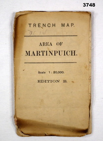 Bendigo Military Museum
Map - TRENCH MAP WW1, 1916
Areas covered by this map are, “Longueval, Delville Wood, Flers, Thiepval”. Item re William Alexander No 502 AIF. Refer Cat No 3746.3 for his service details.Trench map, France, Area of Martin Puch, scale 1:20,000 Edition B, trenches corrected to 24.7.1916, enemy trenches in red.map, trench, france -
 Bendigo Historical Society Inc.
Document - MCCOLL, RANKIN AND STANISTREET COLLECTION: CENTRAL DEBORAH GOLD MINING COMPANY N/L GOLD MINING LEASE, 31 October 1950
Document: Central Deborah Gold Mining Company N/L gold mining lease. 4 page document with attached map. Map shows area from Breen Street to Victoria Street following the line of Old Violet Street.. Lease between Central Deborah Gold Mining Company N/L and the State of Victoria. No. 11230, Vol 331 Fol 36471.organization, mining, gold mining lease, central deborah gold mining company n/l; gold mining lease -
 Canterbury History Group
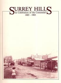
Book, Surrey Hills History Nook, Surrey Hills: In Celebration of the Centennial 1883-1983, November 1983
Collection of recollections and photographs of early history of Surrey Hills58 pages, includes b & w photos, appendices, plus separate index documentnon-fictionCollection of recollections and photographs of early history of Surrey Hillssurrey hills, transport, empire day, churches, schools, recreation, reminiscences -
 Kiewa Valley Historical Society
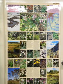
Map / Chart, Vegetation Map & Guide to Alpine Flora: Pretty Valley, 1982
This poster shows Pretty Valley is on the Victorian High Plains where the State Electricity Commission of Victoria worked on the Kiewa Hydro Scheme. Also cattle have grazed in the area over the years. This map is of interest to compare the flora in the area with times prior to 1982 and after 1982.This poster has historical and research value as it shows the flora in the pretty valley area therefore making it significant for people interested in plants. Also for those who would like to compare what plants are still in this area after 1982 and if the cattle grazing, climate change, of bush fires have had on the environment. Thus this poster also has good interpretive capacity of these reasons. Laminated double sided vegetation map and photographic guide to Alpine flora of the Pretty Valley areapretty valley. bogong. vegetation. plants. flowers. alpine. victorian high plains. cattle grazing. s.e.c.v. -
 Falls Creek Historical Society
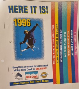
Booklet - Falls Creek Guide 1996 - HERE IT IS!
Falls Creek Resort Management produce a range of marketing materials for each season. This publication titled "HERE IT IS!" aims to include everything you need to know about skiing at Falls Creek in one guide. It also included a Ski Trail map. Sections included are:- What's new in Falls Creek for 1995 A little bit of History/fast facts Trail map and skiing tips Falls Creek Ski School Village map and directory A - Z Resort facilitiesThis item is significant because it illustrates how Falls Creek has been marketed and promoted over time.A coloured publication including images, maps and text covering all aspects of Falls Creek for the 1996 season. The cover features an image of a skier in the air. Seven sections are colour coded on the right hand edge of At bottom of page logos are included Left to right;- Alpine Resorts Commission Victoria; Falls Creek: Falls Creek Ski Guaranteefalls creek facilities, falls creek activities, falls creek marketing