Showing 1511 items matching "land use"
-
 Kew Historical Society Inc
Plan, Melbourne & Metropolitan Board of Works : Borough of Kew : Detail Plan No.1571, 1904
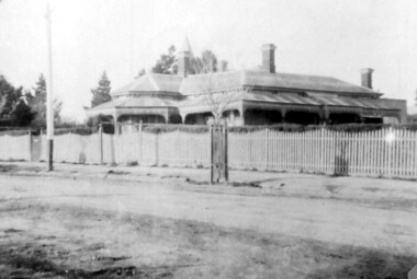
The Melbourne and Metropolitan Board of Works (MMBW) plans were produced from the 1890s to the 1950s. They were crucial to the design and development of Melbourne's sewerage and drainage system. The plans, at a scale of 40 feet to 1 inch (1:480), provide a detailed historical record of Melbourne streetscapes and environmental features. Each plan covers one or two street blocks (roughly six streets), showing details of buildings, including garden layouts and ownership boundaries, and features such as laneways, drains, bridges, parks, municipal boundaries and other prominent landmarks as they existed at the time each plan was produced. (Source: State Library of Victoria)This plan forms part of a large group of MMBW plans and maps that was donated to the Society by the Mr Poulter, City Engineer of the City of Kew in 1989. Within this collection, thirty-five hand-coloured plans, backed with linen, are of statewide significance as they include annotations that provide details of construction materials used in buildings in the first decade of the 20th century as well as additional information about land ownership and usage. The copies in the Public Record Office Victoria and the State Library of Victoria are monochrome versions which do not denote building materials so that the maps in this collection are invaluable and unique tools for researchers and heritage consultants. A number of the plans are not held in the collection of the State Library of Victoria so they have the additional attribute of rarity.Digital copy of the original survey plan, issued by the MMBW to a contractor with responsibility for constructing sewers in the area identified on the plan within the Borough of Kew. The plan was at some stage hand-coloured, possibly by the contractor, but more likely by officers working in the Engineering Department of the Borough and later Town, then City of Kew. The hand-coloured sections of buildings on the plan were used to denote masonry or brick constructions (pink), weatherboard constructions (yellow), and public buildings (grey). This plan is part of a large and historically significant group of MMBW plans and maps that was donated to the Society by the Mr Poulter, City Engineer of the City of Kew in 1989. When the contracts were let for surveyors to identify and record the extant houses and landscapes within an area for the Board of Works, the contracts were let at separate times, hence the anomaly where two copies of Plan No.1571 exist in our collection. The first of these plans identifies the building materials used in houses bordering Fitzwilliam Street, Edgevale Road, May Street, Malin Street, Davis Street and Wellington Street. The cut off point for the survey was the south side of Wellington Street. By 1903 when the survey was undertaken many of the sites were already built on, particularly those facing Edgevale Road. The plan identifies the preponderance of weatherboard houses in the area. The other version of the plan identifies the buildings between Wellington Street and Cotham Road.melbourne and metropolitan board of works, detail plans, mmbw 1571, cartography -
 Kew Historical Society Inc
Plan, Melbourne & Metropolitan Board of Works : Borough of Kew : Detail Plan No.1571, 1904
The Melbourne and Metropolitan Board of Works (MMBW) plans were produced from the 1890s to the 1950s. They were crucial to the design and development of Melbourne's sewerage and drainage system. The plans, at a scale of 40 feet to 1 inch (1:480), provide a detailed historical record of Melbourne streetscapes and environmental features. Each plan covers one or two street blocks (roughly six streets), showing details of buildings, including garden layouts and ownership boundaries, and features such as laneways, drains, bridges, parks, municipal boundaries and other prominent landmarks as they existed at the time each plan was produced. (Source: State Library of Victoria)This plan forms part of a large group of MMBW plans and maps that was donated to the Society by the Mr Poulter, City Engineer of the City of Kew in 1989. Within this collection, thirty-five hand-coloured plans, backed with linen, are of statewide significance as they include annotations that provide details of construction materials used in buildings in the first decade of the 20th century as well as additional information about land ownership and usage. The copies in the Public Record Office Victoria and the State Library of Victoria are monochrome versions which do not denote building materials so that the maps in this collection are invaluable and unique tools for researchers and heritage consultants. A number of the plans are not held in the collection of the State Library of Victoria so they have the additional attribute of rarity.Original survey plan, issued by the MMBW to a contractor with responsibility for constructing sewers in the area identified on the plan within the Borough of Kew. The plan was at some stage hand-coloured, possibly by the contractor, but more likely by officers working in the Engineering Department of the Borough and later Town, then City of Kew. The hand-coloured sections of buildings on the plan were used to denote masonry or brick constructions (pink), weatherboard constructions (yellow), and public buildings (grey). This plan is the other half of Plan No.1571 representing the constructions to the west of Wellington Street before and in 1903/4. This plan represents the built environment in Edgevale Road, Wellington Street, Atkins Street, Annadale Street, Mortimer Street, and Cotham Road. Whereas there are smaller allotments and more modest housing stock facing Edgevale Road, larger blocks and more substantial houses are represented facing Cotham Road.melbourne and metropolitan board of works, detail plans, mmbw 1571, cartography -
 Kew Historical Society Inc
Plan, Melbourne & Metropolitan Board of Works : Borough of Kew : Detail Plan No.1572, 1905
The Melbourne and Metropolitan Board of Works (MMBW) plans were produced from the 1890s to the 1950s. They were crucial to the design and development of Melbourne's sewerage and drainage system. The plans, at a scale of 40 feet to 1 inch (1:480), provide a detailed historical record of Melbourne streetscapes and environmental features. Each plan covers one or two street blocks (roughly six streets), showing details of buildings, including garden layouts and ownership boundaries, and features such as laneways, drains, bridges, parks, municipal boundaries and other prominent landmarks as they existed at the time each plan was produced. (Source: State Library of Victoria)This plan forms part of a large group of MMBW plans and maps that was donated to the Society by the Mr Poulter, City Engineer of the City of Kew in 1989. Within this collection, thirty-five hand-coloured plans, backed with linen, are of statewide significance as they include annotations that provide details of construction materials used in buildings in the first decade of the 20th century as well as additional information about land ownership and usage. The copies in the Public Record Office Victoria and the State Library of Victoria are monochrome versions which do not denote building materials so that the maps in this collection are invaluable and unique tools for researchers and heritage consultants. A number of the plans are not held in the collection of the State Library of Victoria so they have the additional attribute of rarity.Original survey plan, issued by the MMBW to a contractor with responsibility for constructing sewers in the area identified on the plan within the Borough of Kew. The plan was at some stage hand-coloured, possibly by the contractor, but more likely by officers working in the Engineering Department of the Borough and later Town, then City of Kew. The hand-coloured sections of buildings on the plan were used to denote masonry or brick constructions (pink), weatherboard constructions (yellow), and public buildings (grey). Plan No. 1572 represents the built environment bordered by Barkers Road, Wrixon Street, Edgevale Road and Fitzwilliam Street. Other streets identified on the plan include Stansell Street. Plan 1572 shows that by 1903-05, there was only patchy development in this area of Kew, mainly on Edgevale Road and Fitzwilliam Street. Only two named houses are identified: the quaintly named ‘Tweed Cottage’, and ‘Mendip’. The earliest reference to Treed Cottage in Australian newspapers is to the death of Walter Thompson, aged 74 who was a resident there in 1885. His youngest daughter was to die there in 1908. Mendip to the north of Tweed Cottage was owned by Henry Thompson; he was to die in 1901; his wife in 1932. At this period of time, Malin Street and Clivedon Court did not extend to Barkers Road.melbourne and metropolitan board of works, detail plans, mmbw 1572, cartography -
 Kew Historical Society Inc
Plan, Melbourne & Metropolitan Board of Works : Borough of Kew : Detail Plan No.1573, 1905
The Melbourne and Metropolitan Board of Works (MMBW) plans were produced from the 1890s to the 1950s. They were crucial to the design and development of Melbourne's sewerage and drainage system. The plans, at a scale of 40 feet to 1 inch (1:480), provide a detailed historical record of Melbourne streetscapes and environmental features. Each plan covers one or two street blocks (roughly six streets), showing details of buildings, including garden layouts and ownership boundaries, and features such as laneways, drains, bridges, parks, municipal boundaries and other prominent landmarks as they existed at the time each plan was produced. (Source: State Library of Victoria)This plan forms part of a large group of MMBW plans and maps that was donated to the Society by the Mr Poulter, City Engineer of the City of Kew in 1989. Within this collection, thirty-five hand-coloured plans, backed with linen, are of statewide significance as they include annotations that provide details of construction materials used in buildings in the first decade of the 20th century as well as additional information about land ownership and usage. The copies in the Public Record Office Victoria and the State Library of Victoria are monochrome versions which do not denote building materials so that the maps in this collection are invaluable and unique tools for researchers and heritage consultants. A number of the plans are not held in the collection of the State Library of Victoria so they have the additional attribute of rarity.Original survey plan, issued by the MMBW to a contractor with responsibility for constructing sewers in the area identified on the plan within the Borough of Kew. The plan was at some stage hand-coloured, possibly by the contractor, but more likely by officers working in the Engineering Department of the Borough and later Town, then City of Kew. The hand-coloured sections of buildings on the plan were used to denote masonry or brick constructions (pink), weatherboard constructions (yellow), and public buildings (grey). This plan has detailed annotations written in red or blue ink, showing prices, which may be the annual valuations of the properties, and some owners’ names, a most unusual feature on contractor's maps. Some areas, such as the buildings of Methodist Ladies’ College (MLC), include the school’s tennis court and swimming pool, but are not coloured to show building materials – did the draftsman just run out of time, or ink, or enthusiasm, before his plan had to be submitted? MLC had been founded in 1882 as a ‘modern school of the first order’ with buildings that formed ‘a collegiate institution for girls unsurpassed in the colonies’. The goal of its founders was to provide a high-class Christian education for girls, comparable with that provided elsewhere for boys. Some shops are shown along Edgevale Road, though they are not designated as commercial premises. Larger houses are depicted, including ‘Fairlawn’ in Barkers Road, and ‘Clevedon’ and ‘Rosehill’ (now demolished) in Fitzwilliam Street.melbourne and metropolitan board of works, detail plans, mmbw 1573, maps - borough of kew, cartography -
 Kew Historical Society Inc
Plan, Melbourne & Metropolitan Board of Works : Borough of Kew : Detail Plan No.1574, 1905
The Melbourne and Metropolitan Board of Works (MMBW) plans were produced from the 1890s to the 1950s. They were crucial to the design and development of Melbourne's sewerage and drainage system. The plans, at a scale of 40 feet to 1 inch (1:480), provide a detailed historical record of Melbourne streetscapes and environmental features. Each plan covers one or two street blocks (roughly six streets), showing details of buildings, including garden layouts and ownership boundaries, and features such as laneways, drains, bridges, parks, municipal boundaries and other prominent landmarks as they existed at the time each plan was produced. (Source: State Library of Victoria)This plan forms part of a large group of MMBW plans and maps that was donated to the Society by the Mr Poulter, City Engineer of the City of Kew in 1989. Within this collection, thirty-five hand-coloured plans, backed with linen, are of statewide significance as they include annotations that provide details of construction materials used in buildings in the first decade of the 20th century as well as additional information about land ownership and usage. The copies in the Public Record Office Victoria and the State Library of Victoria are monochrome versions which do not denote building materials so that the maps in this collection are invaluable and unique tools for researchers and heritage consultants. A number of the plans are not held in the collection of the State Library of Victoria so they have the additional attribute of rarity.Original survey plan, issued by the MMBW to a contractor with responsibility for constructing sewers in the area identified on the plan within the Borough of Kew. The plan was at some stage hand-coloured, possibly by the contractor, but more likely by officers working in the Engineering Department of the Borough and later Town, then City of Kew. The hand-coloured sections of buildings on the plan were used to denote masonry or brick constructions (pink), weatherboard constructions (yellow), and public buildings (grey). This plan shows several very large houses, particularly along Glenferrie Road, and the area now occupied by Ruyton Girls’ School. ‘Tarring’ (incorrectly spelled here as ‘Karring’) was built for Henry Henty in 1872, on part of his original allotment of 20 acres, and ‘Mount View’, which retains its original building and the fountain in the front garden, is part of Ruyton’s Junior School. The most significant change to Tarring and its grounds since 1903, involve the removal of a number of the outbuildings, including a Burmese temple, bought by Henty from the Burmese Exhibit at the Great Exhibition of 1880. It is shown on the plan as a summerhouse. The two-storey mansion, on the corner of Glenferrie Road and Wellington Street, was built in 1891 by leading architect Alfred White as his own home. Having an initial N.A.V. of £160, the house was purchased by a warehouseman Henry Lister, by 1900, when the N.A.V. was recorded at £111. By the turn of the century the house was known as ‘Comaques’. By contrast, much smaller houses are shown in Scott and Byron Streets, including a tiny Mission Hall in Byron Street, which belonged to the Anglican Church from at least 1903 to 1917.melbourne and metropolitan board of works, detail plans, maps - borough of kew, mmbw 1574, cartography -
 Kew Historical Society Inc
Plan, Melbourne & Metropolitan Board of Works : Borough of Kew : Detail Plan No.1575, 1905
The Melbourne and Metropolitan Board of Works (MMBW) plans were produced from the 1890s to the 1950s. They were crucial to the design and development of Melbourne's sewerage and drainage system. The plans, at a scale of 40 feet to 1 inch (1:480), provide a detailed historical record of Melbourne streetscapes and environmental features. Each plan covers one or two street blocks (roughly six streets), showing details of buildings, including garden layouts and ownership boundaries, and features such as laneways, drains, bridges, parks, municipal boundaries and other prominent landmarks as they existed at the time each plan was produced. (Source: State Library of Victoria)This plan forms part of a large group of MMBW plans and maps that was donated to the Society by the Mr Poulter, City Engineer of the City of Kew in 1989. Within this collection, thirty-five hand-coloured plans, backed with linen, are of statewide significance as they include annotations that provide details of construction materials used in buildings in the first decade of the 20th century as well as additional information about land ownership and usage. The copies in the Public Record Office Victoria and the State Library of Victoria are monochrome versions which do not denote building materials so that the maps in this collection are invaluable and unique tools for researchers and heritage consultants. A number of the plans are not held in the collection of the State Library of Victoria so they have the additional attribute of rarity.Original survey plan, issued by the MMBW to a contractor with responsibility for constructing sewers in the area identified on the plan within the Borough of Kew. The plan was at some stage hand-coloured, possibly by the contractor, but more likely by officers working in the Engineering Department of the Borough and later Town, then City of Kew. The hand-coloured sections of buildings on the plan were used to denote masonry or brick constructions (pink), weatherboard constructions (yellow), and public buildings (grey). Plan No.1575 shows that in the area bounded by Wellington Street, Edgevale Road, Glenferrie Road, and Cotham Road, there had already been significant subdivision of land and houses constructed. As one of the highest points in Kew, as expected, there were already some significant mansions built on large allotments of land. Many of these mansions are identified by name on the plan such as ‘Kelso’, ‘Abbotsford’, ‘Clarendon’ and ‘Ashlyn’ in Cotham Road. Other houses of equal size are unnamed on the plan.melbourne and metropolitan board of works, detail plans, maps - borough of kew, mmbw 1575, cartography -
 RMIT GSBL Justice Smith Collection
Book, Wiseman, H. Dallas, The law relating to the transfer of land : comprising the Transfer of Land Act 1928 (Victoria) and other acts affecting the transfer of land with commentary, notes of Australasian decisions, forms in general use and rulings and practice of the office of titles, 1931
Second editionvictoria. transfer of land act 1928, real property -- victoria, transfer (law) -- victoria, land titles -- registration and transfer -- victoria -
Kew Historical Society Inc
Archive (Sub-series) - Subject File, Latrobe Golf Club
Kew Historical SocietySince its foundation in 1958, members of the Kew Historical Society have been compiling and storing information about subjects relating to the history of Kew and its environs, of which this file is an example. Arranged by Secondary Values (value of records to users)Subject file containing information about the Latrobe Golf Club and course. The file contains a copy of a 1959 newspaper account of the building of the clubhouse on part of the former Lucern Farm which Thomas Wills established 120 years previously. The farm was later owned by Perce Lay, a Gallipoli veteran who progressively sold off parts until only 24 aces of the original 176 acres was left. The file also has a typescript of the back of Lucern Farm sale brochure for the auction on 14/4/1956. suggesting possible uses. Also gives an account of Thomas Wills' life and the improvements he made to the land. thomas wills, lucern farm, perce lay, latrobe golf coursethomas wills, lucern farm, perce lay, latrobe golf course -
 Kew Historical Society Inc
Photograph - Yarra Valley Floods: Kew East, 1916
Flooding of the Yarra Valley, including that section of the Yarra bordering Kew and Kew East in the north and west of the municipality, was a regular occurrence. Extreme flood events of the Yarra River are recorded to have occurred in 1891, 1901, 1916, 1923 and 1934. The Municipality of Kew's response to these floods was to enact planning decisions restricting residential development in flood prone areas following the floods of 1916, 1921 and 1934. While floods continued after the development of the Upper Yarra Reservoir (construction 1948-57), the regularity and extent of these inundations diminished. During the nineteenth century, the land abutting the south side of the Yarra in Kew was devoted to dairy farming. In the twentieth century, before and after the construction of the Eastern Freeway, much of this low-lying area was used as golf courses and public parks.One of a collection of photographs of flooding in the Kew section of the Yarra Valley which are in important research resource for the location and extent of flooding in the first half of the twentieth century. Flooding of the Yarra Valley at East Kew in 1916. The view is taken from the intersection of Kilby Road with what is believed to be Birdwood Street, looking across the flood waters to Ivanhoe. The extensive flooded area shown in the photograph would have included the Kew Golf Club. Verso: "Floods along Kilby Road / near Birdwood St? & Kilby Road / 1917? / 87yarra river, yarra valley, floods -- kew, kilby road -- kew (vic.), kew golf club -
 Kew Historical Society Inc
Photograph - Yarra Valley at Kew, 1918
During the nineteenth century, the land abutting the south side of the Yarra in Kew was devoted to dairy farming. In the twentieth century, before and after the construction of the Eastern Freeway, much of this low-lying area was used as golf courses and public parks.View of the farmland in the Yarra Valley at what is believed to be East Kew in 1918. Verso: "Willsmere / East Kew? / 1918"yarra river, yarra valley -
 Kew Historical Society Inc
Photograph - Yarra Valley Floods: Kew East, 1916
Flooding of the Yarra Valley, including that section of the Yarra bordering Kew and Kew East in the north and west of the municipality, was a regular occurrence. Extreme flood events of the Yarra River are recorded to have occurred in 1891, 1901, 1916, 1923 and 1934. The Municipality of Kew's response to these floods was to enact planning decisions restricting residential development in flood prone areas following the floods of 1916, 1921 and 1934. While floods continued after the development of the Upper Yarra Reservoir (construction 1948-57), the regularity and extent of these inundations diminished. During the nineteenth century, the land abutting the south side of the Yarra in Kew was devoted to dairy farming. In the twentieth century, before and after the construction of the Eastern Freeway, much of this low-lying area was used as golf courses and public parks.One of a collection of photographs of flooding in the Kew section of the Yarra Valley which are in important research resource for the location and extent of flooding in the first half of the twentieth century. Flooding of the Yarra Valley at East Kew in 1916. The view is taken from a street (maybe Birdwood Avenue) intersecting with Kilby Road looking northeast across the flood waters to Ivanhoe and Heidelberg. The extensive flooded area shown in the photograph would have included remnant dairy farms and the Kew Golf Club. Verso: "Floods / Yarra River / East Kew / Kilby Road / 1917? / 87"yarra river, yarra valley, floods -- kew, kilby road -- kew (vic.), kew golf club -
 Kew Historical Society Inc
Photograph - Yarra Valley at Kew, 1912
During the nineteenth century, the land abutting the south side of the Yarra in Kew was devoted to dairy farming. In the twentieth century, before and after the construction of the Eastern Freeway, much of this low-lying area was used as golf courses and public parks.Real-photo postcard of the farmland in the Yarra Valley in what is believed to be North Kew in 1912. Verso: "Willsmere / East Kew / 1912"yarra river, yarra valley, farming -- kew (vic.) -
 Kew Historical Society Inc
Photograph - Flooding at parkland at rear of Guide Dogs Victoria, 1993
The land currently occupied by Guide Dogs Victoria was once part of the grounds of the Kew Lunatic Asylum. This includes the land, designated as parkland which adjoins the Yarra River. It is now designated as the Chandler Park.Original colour small format polaroid photograph of flooding in parkland at the rear of Guide Dogs Victoria in the area now used as the Main Yarra Trail; taken on 16 September 1993."Flooding of land rear of Guide Dogs land 16.9.93"yarra river -- floods -- kew (vic.), guide dogs victoria, main yarra trail, chandler park -
 Kew Historical Society Inc
Photograph - Flooding of shared path at rear of Guide Dogs Victoria, 1993
The land currently occupied by Guide Dogs Victoria was once part of the grounds of the Kew Lunatic Asylum. This includes the land, designated as parkland which adjoins the Yarra River. Original colour small format polaroid photograph of flooding in parkland at the rear of Guide Dogs Victoria in the area now used as the Main Yarra Trail; taken on 16 September 1993."Flooding of shared path on 16.9.93 / Rains 15.9.93 - rear Guide Dogs [Victoria] land"yarra river -- floods -- kew (vic.), guide dogs victoria, main yarra trail, chandler park -
 Kew Historical Society Inc
Photograph - Flooding of the Yarra Valley at Kew East, 1974
Flooding of the Yarra Valley, including that section of the Yarra bordering Kew and Kew East in the north and west of the municipality, was a regular occurrence. Extreme flood events of the Yarra River are recorded to have occurred in 1891, 1901, 1916, 1923 and 1934. The Municipality of Kew's response to these floods was to enact planning decisions restricting residential development in flood prone areas following the floods of 1916, 1921 and 1934. While floods continued after the development of the Upper Yarra Reservoir (construction 1948-57), the regularity and extent of these inundations diminished. During the nineteenth century, the land abutting the south side of the Yarra in Kew was devoted to dairy farming. In the twentieth century, before and after the construction of the Eastern Freeway, much of this low-lying area was used as golf courses and public parks.Late example of the capacity of the Yarra Valley at Kew to flood, even though drainage works and the Upper Yarra Reservoir had reduced their regularity.Original black and white print photograph of the low-lying land at East Kew under floodwater on 16 May 1974. The vantage point of the photographer is Lister Street. In the photo, the fences of the Kilby Farm can be seen. Flooding was caused by overflowing water in Glass' Creek and the River Yarra. Annotation verso: "Hay's Paddock op No.30 Lister Street / 16 May 1974 11.50am / R.L. 46.04"hays paddock, floods, yarra river, glass' creek, lister street -
 Kew Historical Society Inc
Photograph - Flooding of the Yarra Valley at Kew East, 1974
Flooding of the Yarra Valley, including that section of the Yarra bordering Kew and Kew East in the north and west of the municipality, was a regular occurrence. Extreme flood events of the Yarra River are recorded to have occurred in 1891, 1901, 1916, 1923 and 1934. The Municipality of Kew's response to these floods was to enact planning decisions restricting residential development in flood prone areas following the floods of 1916, 1921 and 1934. While floods continued after the development of the Upper Yarra Reservoir (construction 1948-57), the regularity and extent of these inundations diminished. During the nineteenth century, the land abutting the south side of the Yarra in Kew was devoted to dairy farming. In the twentieth century, before and after the construction of the Eastern Freeway, much of this low-lying area was used as golf courses and public parks.Late example of the capacity of the Yarra Valley at Kew to flood, even though drainage works and the Upper Yarra Reservoir had reduced their regularity.Original black and white print photograph of the low-lying land at East Kew under floodwater on 16 May 1974. The vantage point of the photographer is Lister Street. Flooding was caused by overflowing water in Glass' Creek and the River Yarra. Annotation verso: "Lister Street looking north / Flood level / 16 May 1974 11.30am / R.L. 46.04"hays paddock, floods, yarra river, glass' creek, lister street -
 Kew Historical Society Inc
Photograph - Flooding of the Yarra Valley at Kew East, 1974
Flooding of the Yarra Valley, including that section of the Yarra bordering Kew and Kew East in the north and west of the municipality, was a regular occurrence. Extreme flood events of the Yarra River are recorded to have occurred in 1891, 1901, 1916, 1923 and 1934. The Municipality of Kew's response to these floods was to enact planning decisions restricting residential development in flood prone areas following the floods of 1916, 1921 and 1934. While floods continued after the development of the Upper Yarra Reservoir (construction 1948-57), the regularity and extent of these inundations diminished. During the nineteenth century, the land abutting the south side of the Yarra in Kew was devoted to dairy farming. In the twentieth century, before and after the construction of the Eastern Freeway, much of this low-lying area was used as golf courses and public parks.Late example of the capacity of the Yarra Valley at Kew to flood, even though drainage works and the Upper Yarra Reservoir had reduced their regularity.Original black and white print photograph of Hay's Paddock under floodwater on 16 May 1974. The vantage point of the photographer is Keystone Crescent looking east. Flooding was caused by overflowing water in Glass' Creek and the River Yarra. Annotation verso: "Keystone Cr looking east / 16 May 1974 11.50am"hays paddock, floods, yarra river, glass' creek -
 Kew Historical Society Inc
Photograph - Flooding of the Yarra Valley at Kew East, 1974
Flooding of the Yarra Valley, including that section of the Yarra bordering Kew and Kew East in the north and west of the municipality, was a regular occurrence. Extreme flood events of the Yarra River are recorded to have occurred in 1891, 1901, 1916, 1923 and 1934. The Municipality of Kew's response to these floods was to enact planning decisions restricting residential development in flood prone areas following the floods of 1916, 1921 and 1934. While floods continued after the development of the Upper Yarra Reservoir (construction 1948-57), the regularity and extent of these inundations diminished. During the nineteenth century, the land abutting the south side of the Yarra in Kew was devoted to dairy farming. In the twentieth century, before and after the construction of the Eastern Freeway, much of this low-lying area was used as golf courses and public parks.Late example of the capacity of the Yarra Valley at Kew to flood, even though drainage works and the Upper Yarra Reservoir had reduced their regularity.Original black and white print photograph of the low-lying land at East Kew under floodwater on 16 May 1974. The vantage point of the photographer is Lister Street. Flooding was caused by overflowing water in Glass' Creek and the River Yarra. Annotation verso: "Lister St looking same as No.3 / 16 May 1974 11.30"floods, yarra river, glass' creek, lister street -
 Kew Historical Society Inc
Photograph - Flooding of the Yarra Valley at Kew East, 1974
Flooding of the Yarra Valley, including that section of the Yarra bordering Kew and Kew East in the north and west of the municipality, was a regular occurrence. Extreme flood events of the Yarra River are recorded to have occurred in 1891, 1901, 1916, 1923 and 1934. The Municipality of Kew's response to these floods was to enact planning decisions restricting residential development in flood prone areas following the floods of 1916, 1921 and 1934. While floods continued after the development of the Upper Yarra Reservoir (construction 1948-57), the regularity and extent of these inundations diminished. During the nineteenth century, the land abutting the south side of the Yarra in Kew was devoted to dairy farming. In the twentieth century, before and after the construction of the Eastern Freeway, much of this low-lying area was used as golf courses and public parks.Late example of the capacity of the Yarra Valley at Kew to flood, even though drainage works and the Upper Yarra Reservoir had reduced their regularity.Original black and white print photograph of the low-lying land at East Kew under floodwater on 16 May 1974. The vantage point of the photographer is at Willsmere Road. The road itself is underwater.Annotation verso: "Willsmere Rd / Same as No.7 / 16 May 1974 11.15am"floods, yarra river, willsmere road -
 Kew Historical Society Inc
Photograph - Flooding of the Yarra Valley at Kew East, 1974
Flooding of the Yarra Valley, including that section of the Yarra bordering Kew and Kew East in the north and west of the municipality, was a regular occurrence. Extreme flood events of the Yarra River are recorded to have occurred in 1891, 1901, 1916, 1923 and 1934. The Municipality of Kew's response to these floods was to enact planning decisions restricting residential development in flood prone areas following the floods of 1916, 1921 and 1934. While floods continued after the development of the Upper Yarra Reservoir (construction 1948-57), the regularity and extent of these inundations diminished. During the nineteenth century, the land abutting the south side of the Yarra in Kew was devoted to dairy farming. In the twentieth century, before and after the construction of the Eastern Freeway, much of this low-lying area was used as golf courses and public parks.Late example of the capacity of the Yarra Valley at Kew to flood, even though drainage works and the Upper Yarra Reservoir had reduced their regularity.Original black and white print photograph of the low-lying land at East Kew under floodwater on 16 May 1974. The photograph is of Hyde Park looking north-east.Annotation verso: "Hyde Park looking nth-east / Flood Level / 16 May 1974 11.15am / R.L. 46.61"floods, yarra river, hyde park -
 Kew Historical Society Inc
Photograph - Flooding of the Yarra Valley at Kew, 1974
Flooding of the Yarra Valley, including that section of the Yarra bordering Kew and Kew East in the north and west of the municipality, was a regular occurrence. Extreme flood events of the Yarra River are recorded to have occurred in 1891, 1901, 1916, 1923 and 1934. The Municipality of Kew's response to these floods was to enact planning decisions restricting residential development in flood prone areas following the floods of 1916, 1921 and 1934. While floods continued after the development of the Upper Yarra Reservoir (construction 1948-57), the regularity and extent of these inundations diminished. During the nineteenth century, the land abutting the south side of the Yarra in Kew was devoted to dairy farming. In the twentieth century, before and after the construction of the Eastern Freeway, much of this low-lying area was used as golf courses and public parks.Late example of the capacity of the Yarra Valley at Kew to flood, even though drainage works and the Upper Yarra Reservoir had reduced their regularity.Original black and white print photograph of the low-lying land at East Kew under floodwater on 16 May 1974. The photograph is taken from 43 Kellett Grove.Annotation verso: "Kellett Gve No.43 / Flood Level / 16 May 1974 11.40am"floods, yarra river, kellett grove -
Kew Historical Society Inc
Book, Donald Garden, Heidelberg : the land and its people, 1838-1900, 1972
Carlton, Victoria : Melbourne University Press, 1972 x, 219 pages : illustrations, maps, portraits, plates ; 23 cm non-fictionmelbourne --heidelberg to 1900, heidelberg (vic.) -- history. -
 Heidelberg Theatre Company Inc..
Program Photos ReviewSet Design, Liliom by Ferenec Molnar directed by Joy Youlden
The Adult Education Association Drama Group originally staged Liliom at the Union Theatre, University of Melbourne on Saturday, 3rd November, 1951, at 8pm and on the 8th November it was re-staged by them as the opening production of the The City of Heidelberg Repertory Company, now known as the Heidelberg Theatre Company Inc. in the Eistedford Hall, Ivanhoe. Sketch for Prologue, Fair Ground Scene, and Sketch for Scenes 2 and 3, The Tin Type Shop, for Adult Education Association Drama Group production at the Union Theatre from 1st – 3rd November, 1951. Resulting sets were transported to the Eisteddfod Hall, Ivanhoe and used in the opening production in January, 1952 for the newly formed City of Heidelberg Theatre.Sketch for Prologue, Fair Ground Scene, and Sketch for Scenes 2 and 3, The Tin Type Shop, for Adult Education Association Drama Group production at the Union Theatre from 1st – 3rd November, 1951. Resulting sets were transported to the Eisteddfod Hall, Ivanhoe and used in the opening production in January, 1952 for the newly formed City of Heidelberg Theatre. Sketch for Prologue, Fair Ground Scene, and Sketch for Scenes 2 and 3, The Tin Type Shop, for Adult Education Association Drama Group production at the Union Theatre from 1st – 3rd November, 1951. Resulting sets were transported to the Eisteddfod Hall, Ivanhoe and used in the opening production in January, 1952 for the newly formed City of Heidelberg Theatre Company. Photo from unidentified newspaper of the director of Liliom by Ferenc Molnar, Joy Youlden.an Adult Education Association Drama Group production at the Union Theatre from 1st – 3rd November, 1951 and restaged at the Eisteddfod Hall, Ivanhoe as the opening production in January, 1952 for the newly formed City of Heidelberg Repertory Group. The Adult Education Association Drama Group performers, backstage workers and technicians staged the play at the Eisteddfod Hall in Ivanhoe. Local Councillor E.A. Carlyle attended and addressed the audience. Reg Rudd is described as director-producer. He announced another Repertory evening in February. Inagural production under the name of The City of Heidelberg Repertory Company, now known as the Heidelberg Theatre Company Inc., staged in the Eisteddfod Hall, 14 Ivanhoe Parade, Ivanhoe, Victoria, Australia on the 8th November, 1952.All items in good condition. Original and one colour photocopy of hand drawn sketches for the Prologue and Scenes 2 and 3 settings in blue biro with watercolour washes on ecru paper. On the back side of paper with scene sketch of Act 1. Photo – Joy Youlden - Small black and white cutting from unidentified newspaper on newsprint which has yellowed, Cutting has been glued onto ecru A4 paper sheet. Sketch for Scene 6, The Land Beyond, and Sketch for Scene 7, Julies House 16 Years later, an Adult Education Association Drama Group production at the Union Theatre from 1st – 3rd November, 1951. Resulting sets were transported to the Eisteddfod Hall, Ivanhoe and used in the opening production in January, 1952 for the newly formed City of Heidelberg Repertory Group. Sketches for Scene 4, The Railway Embankment, and Sketch for Scene 5, Behind The Shop, an Adult Education Association Drama Group production at the Union Theatre from 1st – 3rd November, 1951. Resulting sets were transported to the Eisteddfod Hall, Ivanhoe and used in the opening production in January, 1952 for the newly formed City of Heidelberg Repertory Group. Handwritten detail of scene numbers and names, name of producer, theatre company AEA (Adult Education Association) Drama Group Show and place, Union Theatre.eistdford hall, fern matthews, city of heidelberg repertory group, adult education association drama group, liliom, liliom by ferenec molnar directed by joy youlden, 1952, 1 -
 Surrey Hills Historical Society Collection
Photograph, Back Creek (later South Surrey Park), c 1936, 1936
... is significant as it shows the transition from rural to urban land use ...This photo was taken at the opening of the footbridge by Sir Winston Dugan in 1936.South Surrey Park was developed on land which had been the property of the Kleinert family. Their land extended from Union Road to Essex Road. They ran horses, ducks and fowls and Emily Kleinert grew flowers. Alan Holt research: Lot 6 was sold to Martin Klienert by Karl Richter in 1860 together with a portion of another adjacent lot. From 1860-1885 Martin worked it as a market garden leasing some land for grazing when it was not required for gardening. He died in 1898. In a formal document, William declared he was the son of Martin "who purchased land in 1860, died in 1898 and the land has been continually occupied by father and family since. It has been cultivated as a market garden; when not being used for gardening it was let for cultivation and grazing." William died in 1939 and the property passed to his sons Martin and Ernest. The family sold the land to the Camberwell Council in the 1950s.This photo is significant as it shows the transition from rural to urban land use in Surrey Hills.Black and white photo taken in the area later known as South Surrey Park. Back Creek is in the foreground. There is a tent on the LHS and approximately 7 houses which front Verdun Street. Some of their backyards face onto the open space along the creek bed.parks and reserves, creeks, south surrey park, civic occasion, official events, back creek, verdun street, 1936, kleinert family, sir winston dugan, topography -
Surrey Hills Historical Society Collection
Photograph, Opening of the footbridge across Back Creek, 1936, 1936
... rural to urban land use in the area. parks and reserves creeks ...This photo was taken at the opening of the footbridge over Back Creek by Sir Winston Dugan, Governor of Victoria, in 1936. He is cutting bunting draped along the bridge rails. South Surrey Park was developed on land which had been the property of the Kleinert family. Their land extended from Union Road to Essex Road. They ran horses, ducks and fowls and Emily Kleinert grew flowers. Alan Holt research: Lot 6 was sold to Martin Klienert by Karl Richter in 1860 together with a portion of another adjacent lot. From 1860-1885 Martin worked it as a market garden leasing some land for grazing when it was not required for gardening. He died in 1898. In a formal document, William declared he was the son of Martin "who purchased land in 1860, died in 1898 and the land has been continually occupied by father and family since. It has been cultivated as a market garden; when not being used for gardening it was let for cultivation and grazing." William died in 1939 and the property passed to his sons Martin and Ernest. The family sold the land to the Camberwell Council in the 1950s.This photo is significant as it documents the change from rural to urban land use in the area.Black and white photo taken at the opening of the footbridge across Back Creek in the area later known as South Surrey Park. Back Creek runs diagonally through the photo with a wooden footbridge prominent. Dignitaries are gathered on the bridge. A tent and houses can just be distinguished in the background.parks and reserves, creeks, south surrey park, civic occasion, official events, back creek, verdun street, footbridges, governor of victoria, sir winston duggan, surrey hills, kleinert family, (mr) karl richter, (mr) martin kleinert, topography -
 Sunbury Family History and Heritage Society Inc.
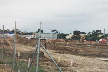
Photograph, 13 April 2000
In 2000 work commenced on the further development of railway land on the west side of Sunbury station for the construction of commercial and entertainment facilities. Prior to this time the land had been undeveloped and was often used to accommodate visiting circus troupes. Cereal storage silos also occupied this area for some time. The development of this area has been a reflection of the rapid expansion of settlement within Sunbury and surrounding areas that occurred during the early years of the twentieth century.A coloured photograph of a fenced off area undergoing development with earthmoving equipment and trucks in operation and some commercial buildings visible in the middle distance.sunbury railway station -
 Surrey Hills Historical Society Collection
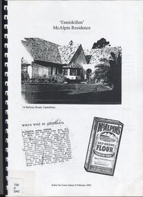
Book, Robin Da Costa-Adams, Enniskillen McAlpin Residence, Feb-09
This report was prepared by historian Robin da Costa-Adams to assess the cultural heritage significance of "Enniskillen" at 14 Balwyn Road, Canterbury. It includes some family history on a number of prominent families - the McAlpin family, the Hindson family and the architect, Arthur William Plaisted who designed 'Enniskillen' for the McAlpin family. McAlpin's was a major Victorian flour company in the nineteenth and early twentieth centuries. Owned and operated by J. McAlpin and Sons, the company sold its flour products across Australia and overseas. McAlpin's developed a successful marketing campaign which was pitched directly at housewives. One innovation was the publishing of a free cookbook which had recipes in it that used McAlpin's products. These free cookbooks were published successively from the 1930s through to the 1960s in Australia. Arthur Plaisted also designed the Surrey Hills Medical Centre in Union Road c1911. Some of his work is featured on the State Library of Victoria Collection. Robin da Costa-Adams has researched and written many publications including 'Blackburn a picturesque history, 1978'; 'Land of Gold: Gwlad yr Aur: James Tipping and a Mining Heritage'; 'Address (with signatories) from the women of Ballarat & Ballarat East to the women of England 1864 : against transportation of convicts', compiled and indexed by Robin; and 'Connie's Story : commemorating the Life of Mrs Edward (Plorn) Dickens'. Robin has been a tireless campaigner for heritage protection in Canterbury. This document on 'Enniskillen' was included with Robin's submission for 2 VCAT hearings regarding possible development of the property. Both resulted in a judgement against the proposed developments. In the recent (2021) hearing the document was specifically mentioned in the judgement.A report prepared by Robin da Costa-Adams in 2009 to assess the cultural heritage significance of "Enniskillen" at 14 Balwyn Road, Canterbury. It includes some family history on the McAlpin family, the Hindson family and the architect Arthur WIlliam Plaisted family.(mr) arthur plaisted, (mr) walter plaisted, enniskillen, shrublands, house names, (mr) francis henty, (mrs) mary henty, (mr) ernest carter, heathfield, (mr) john hindson, (mrs) alice hindson, (mr) william hindson, (mrs) annie west mcalpin, (mr) john mcalpin, mcalpin bakery, (mr) keith matthies, dental surgeon, (mr) william wolf, architects, (miss) mary beacon, robin ca costa-adams -
 Surrey Hills Historical Society Collection
Photograph, Mrs Caroline de Graaf
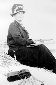
Mrs Caroline de Graaf photographed in 1929. Caroline and James de Graaf were married in 1885 and came to live in Surrey Hills. They had two blocks of land at 13 Charles Street. At first James rode his bicycle to his work in Richmond and each week Caroline would walk to Richmond carrying her baby to see her parents. They would put their shopping on the bike and walk home in the evening. Eventually train schedules suited them and they were relieved to be able to use the train for the trip. James later became employed in the timber trade in Box Hill. A black and white photograph of a lady seated on the sand. She is wearing a coat and hat and carrying a bag. There is another bag on the sand beside her. It is possibly a camera bag.(mrs) caroline de graaf, (mr) james de graaf, charles street, surrey hills, clothing and dress -
 Surrey Hills Historical Society Collection
Photograph, 386-384 Canterbury Road Surrey Hills
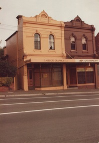
The donor, Bob Lennox believed that these were the work of his great-grandfather William Lennox and his builders. William and his son were plasterers and often used the shell motif which is seen on the pediment of the buildings. These two terraces were part of the retail development of five terraces along Canterbury Road which were constructed on land subdivided from the parcel of land originally owned by John Woodhead. The Alan Holt register of properties in 3127 gives a list of proprietors / residents at the beginning of each decade from 1890-1980. There are also earlier photos depicting these buildings in the collection. These buildings have been included in the City of Boroondara Heritage Overlay Union Road Commercial Precinct 2011, Surrey Hills.These buildings were amongst the first commercial buildings serving the area of Surrey Hills and followed the extension of the railway from Camberwell in 1883.A colour photo with rounded corners taken from slightly diagonally across Canterbury Road from 2 double-storey Victorian style buildings. Both have the decorative shell motif in the pediment.Back of photo in green pencil "CANTERBURY RD SURREY HILLS / EAST OF UNION RD"victorian style, allegro graphics, william lennox, 386-384 canterbury road, shops, victorian terraces, canterbury road, surrey hills, john woodhead, heritage overlay union road commercial precinct 2011, heritage overlays -
 Surrey Hills Historical Society Collection
Photograph, 215 Union Road, c 1920
The house was variously known as ‘Mintaro’, ‘Montiere’ and ‘Goonoo Goonoo’, the later after 1920 when it was purchased by Natale Cerini and his wife Ethel May (nee Swan), who were married in 1918. Built 1887-1888 by William Wigley. The original colour was deep cream with dark green trim. Property included a block of land on south side and also land to the north. The original coach house was on what became 213 Union Road and was used to build a yacht in by the then neighbours, the Flemings. The street plane trees were replaced in the 1970s with melaleucas and in 1987 new plane trees were planted between the melaleucas. Sepia copy of an older photo of 215 Union Road from diagonally across the road. Shows street surface, bluestone kerbing, a young tree within a guard and a Victorian style home with 3 chimneys, a slate roof and a veranda on at least the south and west side. Beyond the house are mature cypress and other trees and a spire. The spire belonged to Surrey College, a boys' boarding school (later Nethercourt Hospital and St Judes.)'mintaro', 'montiere', 'goonoo goonoo', william wigley, mrs ethel may cerini, miss ethel may swan, miss jocelyn cerini, mrs jocelyn hall, miss lynette cerini, victorian style, 215 union road