Showing 2185 items
matching nillumbik
-
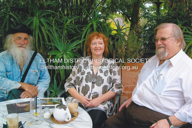
 Eltham District Historical Society Inc
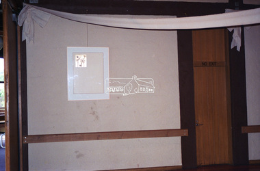
Negative - Photograph, Art show, Eltham Community Centre, c.1994
An art auction for the Save the Copper Butterfly campaign arranged by Pauline Toner was held in 1987 at which a number of which were acquired by the Shire of Eltham for the Eltham Art Collection, now part of the Nillumbik Art Collection. This show circa 1994 in the Eltham Community Centre displayed several of the works.Roll of 35mm colour negative film, 1 stripKodak Gold 100-4art exhibition, eltham community centre, eltham copper butterfly, nillumbik art collection, ona wendi henderson -
 Eltham District Historical Society Inc
Book, Cadel Evans: the art of cycling, 2016
The autobiography of "Australia's greatest cyclist" Cadel Evans. He is one of only two non-Europeans to have won the Tour de France (bike race), which he won in 2011. Cadel Evans spent much of his youth growing up in the rural area of the Shire of NillumbikHardbackracing cyclist, olympian, athlete, cadel evans, autobiography -
 Eltham District Historical Society Inc
Newsletter, No. 111 November 1996
Contents: • Next meeting, guest speaker; Robert Wuchatsch: Westgarthtown • November Meeting • Christmas Function • Society Headquarters • President’s Report • Spring Excursion • Eltham Heritage Trail • Nillumbik Heritage Study • More News • A Punt Across the Yarra at Eltham? • Former Eltham Shire Office Site The Shire of Eltham Historical Society was formed in October 1967. The first newsletter of the Society was issued May 1978 and has been published continuously ever since on a bi-monthly basis. With the cessation of the Shire of Eltham in late 1994, the Society's name was revised to Eltham District Historical Society and this name first appeared with issue No. 103, July 1995. The collection of the Society's newsletters provides a valuable resource on the history of the Society's activities, office bearers and committee members, guest speakers and subjects of historical interest pertinent to the former Shire of Eltham and the Eltham District.A4 photocopied newsletter distributed to membersnewsletter, eltham district historical society, shire of eltham historical society -
 Eltham District Historical Society Inc
Newsletter, No. 124 January 1999
Contents: • Next meeting, The Nillumbik Arts and Heritage Trail; A workshop presented by Dennis Ward • February Meeting • Society Program 1999 • The Other Elthams • Annual General Meeting • Andrew Ross Museum • The Eltham Railway Bridge • Some Other Snippets • 1976 ‘Save the Trestle Bridge’ Poster The Shire of Eltham Historical Society was formed in October 1967. The first newsletter of the Society was issued May 1978 and has been published continuously ever since on a bi-monthly basis. With the cessation of the Shire of Eltham in late 1994, the Society's name was revised to Eltham District Historical Society and this name first appeared with issue No. 103, July 1995. The collection of the Society's newsletters provides a valuable resource on the history of the Society's activities, office bearers and committee members, guest speakers and subjects of historical interest pertinent to the former Shire of Eltham and the Eltham District.A4 photocopied newsletter distributed to membersnewsletter, eltham district historical society, shire of eltham historical society -
 Eltham District Historical Society Inc
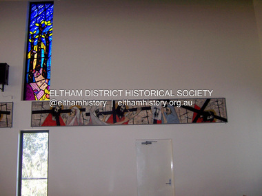
Photograph - Digital Photograph, Marguerite Marshall, Stations of the Cross, Clifton Pugh (1961); Our Lady Help of Christian's Church, Henry Street, Eltham, 11 October 2006
Stations of the Cross by Clifton Pugh is a contempooray art piece in four sections making up 11 stations of the cross. It was commissioned by the Catholic parish in Eltham (Our Lady Help of Christians) in 1961 Published: Nillumbik Now and Then / Marguerite Marshall 2008; photographs Alan King with Marguerite Marshall.; p81This collection of almost 130 photos about places and people within the Shire of Nillumbik, an urban and rural municipality in Melbourne's north, contributes to an understanding of the history of the Shire. Published in 2008 immediately prior to the Black Saturday bushfires of February 7, 2009, it documents sites that were impacted, and in some cases destroyed by the fires. It includes photographs taken especially for the publication, creating a unique time capsule representing the Shire in the early 21st century. It remains the most recent comprehenesive publication devoted to the Shire's history connecting local residents to the past. nillumbik now and then (marshall-king) collection, art, clifton pugh, stations of the cross, our lady help of christans, installation -
 Greensborough Historical Society
Newspaper clipping, Diamond Valley Leader, Enlisting help: stories honour Anzacs; with Yarra Plenty Regional Library flyer advertising Discover your Anzac story program, 26/11/2014
Research by Maureen Jones about Sgt. Reginald Simms and Nurse Elizabeth Gallagher as part of Yarra Plenty Regional Library publication program about people from Nillumbik, Banyule and Whittlesea who served in World War 1. Includes Yarra Plenty Regional Library flyer about the project.Front page colour image and article and image p. 5. Small colour flyer.world war 1, maureen jones, yarra plenty regional library, reginald simms, elizabeth gallagher -
 Greensborough Historical Society
Map, Melbourne and Metropolitan Board of Works. Survey Division, MMBW, Yarra 2500 / 16.23. Diamond Creek, 1978_02
Melbourne and Metropolitan Board of Works. Yarra 2500 [base map] 16-23. Diamond Creek. Parish of Nillumbik 3310. Municipalities of Diamond Valley 257 and Eltham 238. Prominent streets include: Phipps Crescent, Bishop Avenue, and Reynolds Road. Includes the former Diamond Creek Technical School.MMBW Map in 1:2500 [scale] series. Cream parchment with green tape reinforcing on edges and punched holes on left edge.mmbw, melbourne and metropolitan board of works, shire of diamond valley, diamond creek - maps -
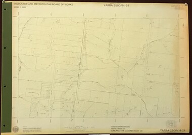 Greensborough Historical Society
Map, Melbourne and Metropolitan Board of Works. Survey Division, MMBW, Yarra 2500 / 14.24. Plenty, 1979_05
Melbourne and Metropolitan Board of Works. Yarra 2500 [base map] 14.24. Plenty. Parishes of Nillumbik 3310 and Morang 3183. Municipality of Diamond Valley 257. Prominent streets include: Heard Road, Hillmartin Road and Yan Yean Road. Features include Plenty Primary School and Plenty Park.MMBW Map in 1:2500 [scale] series. Cream parchment with green tape reinforcing on edges and punched holes on left edge.mmbw, melbourne and metropolitan board of works, shire of diamond valley, plenty - maps -
 Nillumbik Shire Council
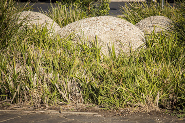
Public Art: Helen BODYCOMB (b.1964, South Australia) and Enver CAMDAL (Lives and works Turkey), Enver Camdal et al, Nest (Location: Roundabout, Main and Luck Street, Eltham), 1997
Commissioned by Nillumbik Shire Council - 1997 The selection panel in the commissioning process to this 'extraordinary acquisition' was Rhonda Noble, Director of La Trobe University Museum of Art, Jeph Neale, Eltham Roundabout Advisory Group, Chris Marks, NSC Curator of Collections, Geoff Glynn, NSC Manager of Infrastructure Development.'Nest' highlights the indigenous flora and fauna of the Shire. The stiff, coarse grass used to create the nest is indigenous to the area and the eggs are like those of the spotted quail thrush, a ground-nesting bird of the Shire. The circular flow or placement of the eggs recalls the revolution of the seasons and nesting cycles. There is a tall light pole above the eggs, shining down at night. The effect is of a giant incubator. Enrichment and nurturing of the larger environment can be associated with this sculpture. This work resembles a large bird's nest, with three egg-like forms of fibreglass covered in a pebble render, set on sand. The nest is positioned within the paved boundary of the roundabout. The nest shape has been created out of stiff, coarse indigenous grass, periodically trimmed so the view is not obstructed. The eggs are a brown-speckled, creamy yellow colour. The three eggs are arranged in a ring, with the narrow end of each pointing to the large end of the next, in a circle that mimics the flow of traffic. N/Apublic art, nest, eggs, eltham, ekphrasis2017, mosaic, pebbles, roundabout, spotted quail thrush -
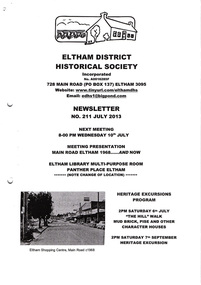 Eltham District Historical Society Inc
Newsletter, No. 211 July 2013
Contents: • Next meeting, Presentation: Main Road Eltham 1968…..And Now • July Meeting • July Excursion – Mud Bricks, Pise and Other ‘Character Houses’ • Nillumbik Reconciliation Plaques • A Busy Time for Enquiries, Donations and Other Things • Mac Ball • Former Hat Factory • Avenue of Honour • And Also The Shire of Eltham Historical Society was formed in October 1967. The first newsletter of the Society was issued May 1978 and has been published continuously ever since on a bi-monthly basis. With the cessation of the Shire of Eltham in late 1994, the Society's name was revised to Eltham District Historical Society and this name first appeared with issue No. 103, July 1995. The collection of the Society's newsletters provides a valuable resource on the history of the Society's activities, office bearers and committee members, guest speakers and subjects of historical interest pertinent to the former Shire of Eltham and the Eltham District.A4 photocopied newsletter distributed to membersnewsletter, eltham district historical society, shire of eltham historical society -
 Eltham District Historical Society Inc
Photograph - Digital Photograph, Alan King, St Matthew's Church and Hall, Panton Hill, 27 March 2008
St. Matthew's Church has historic significance as the town's church and physical and social focus for the community. The standard design buildings are good examples and important streetscape elements. The war memorial cross is the area's monument to the 20th century wars and its modest scale in comparison with the granite Eltham and towered Kangaroo Ground memorials illustrates the lack of affluence in the town and surrounding area. The grouping of church, school, store and post office is typical of country villages throughout Victoria. The Radiata Pine plantings are significant as an intact line of shelterbelt planting typical of the early 20th century. (Bick Study 1992) Covered under Heritage Overlay, Nillumbik Planning Scheme. Published: Nillumbik Now and Then / Marguerite Marshall 2008; photographs Alan King with Marguerite Marshall.; p63This collection of almost 130 photos about places and people within the Shire of Nillumbik, an urban and rural municipality in Melbourne's north, contributes to an understanding of the history of the Shire. Published in 2008 immediately prior to the Black Saturday bushfires of February 7, 2009, it documents sites that were impacted, and in some cases destroyed by the fires. It includes photographs taken especially for the publication, creating a unique time capsule representing the Shire in the early 21st century. It remains the most recent comprehenesive publication devoted to the Shire's history connecting local residents to the past. nillumbik now and then (marshall-king) collection, panton hill, st matthew's church, panton hill war memorial -
 Eltham District Historical Society Inc
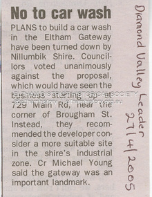
Document - Property Binder, 729 Main Road, Eltham
Newspaper article: Diamond Valley Leader, 27 April 2005, No to car wash. Letter 25 July 2005 from Minter Ellison Lawyers attaching VCAT notice of adjournment. Letter 5 September 2005 re Application for review of Application for Review P1036/2005. Letter 6 September 2005 from Apex Building Design Studio to Minter Ellison Lawyers re carwash development. Newspaper article: Diamond Valley Leader 20 February 2007, Gateway 'blob' bid fails test, Nillumbik Council rejected plan for 3 story building, 12 offices, ship, 8 homes. Notice of Decision to Refuse to Grant a Permit, Application 191/2023/02P, Nillumbik Shire Council, 4 Oct 2023main road, eltham, property, businesses, carwash, apex design studio, eltham gateway, minter ellison lawyers -
 Eltham District Historical Society Inc
Document - Folder, Pittard, Chris and Mary-Lou
Chris and Mary-Lou Pittard, and their daughter Jessie, are ceramicists. Contents Newspaper article: "Students put up mural", Diamond Valley Leader, 15 August 2007. Mary-Lou Pittard, artist in residence at Ivanhoe Grammar School, with the students, created a tile mural. Newspaper article: "Sculptor takes prize", Diamond Valley Leader, 7 July 2010. Chris Pittard wins annual Nillumbik arts prize. Newspaper article: "Thanks for the memories", Warrandyte Diary, February 2022. Mary-Lou Pittard worked with Warrandyte senior citizens on ceramic mural. Flier: Chris and Mary-Lou Pittard Studio Gallery [no date] Newspaper article: "Artistic talent on show", Diamond Valley Leader, 7 March 2018. Jessie Pittard took part in Nillumbik Artists Open Studios program.Newspaper clippings, A4 photocopies, etcmary-lou pittard, chris pittard, ivanhoe grammar school, round square, montsalvat, nillumbik arts prize, jessie pittard, ceramicists, warrandyte, anderson's creek now warrandyte, warrandyte uniting church peace wall, warrandyte community hall, nillumbik artists open studios -
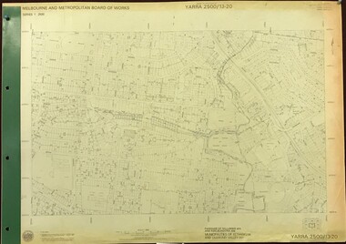 Greensborough Historical Society
Map, Melbourne and Metropolitan Board of Works. Survey Division, MMBW, Yarra 2500 / 13.20. Greensborough, Montmorency and Watsonia, 1979_03
Melbourne and Metropolitan Board of Works. Yarra 2500 [base map] 13-20. Greensborough, Montmorency and Watsonia. Parishes of Nillumbik 3310 and Keelbundora 2856. Municipalities of Eltham 238 and Diamond Valley 257. Prominent streets include: Nell Street, Nepean Street and Alexandra Street. Includes Montmorency High School.MMBW Map in 1:2500 [scale] series. Cream parchment with green tape reinforcing on edges and punched holes on left edge.mmbw, melbourne and metropolitan board of works, shire of diamond valley, greensborough - maps, montmorency - maps, watsonia - maps -
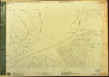 Greensborough Historical Society
Map, Melbourne and Metropolitan Board of Works. Survey Division, MMBW, Yarra 2500 / 16.24. Northern Diamond Creek and Wattle Glen, 1978_02
Melbourne and Metropolitan Board of Works. Yarra 2500 [base map] 16-24. Northern Diamond Creek and Wattle Glen. Parishes of Nillumbik 3310 and Greensborough 2724. Municipalities of Diamond Valley 257 and Eltham 238. Prominent streets include: Hurstbridge Road, and Reynolds Road. Includes Wattle Glen Station.MMBW Map in 1:2500 [scale] series. Cream parchment with green tape reinforcing on edges and punched holes on left edge.mmbw, melbourne and metropolitan board of works, shire of diamond valley, wattle glen - maps, diamond creek - maps -
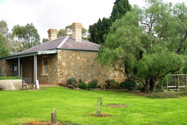 Greensborough Historical Society
Photograph - Digital image, Marilyn Smith, Ellis Cottage, May 2016: 1 (Exterior), 27/05/2016
In May 2016, the Nillumbik Historical Society invited Greensborough Historical Society to visit its historical centre at Ellis Cottage in Diamond Creek. Ellis Cottage was built in 1865 and is made of local uncut stone. The cottage is a typical farmers residence of this period. The stone construction is unique in this district as most construction is weatherboard. Digital colour photographellis cottage, nillumbik historical society inc. -
 Eltham District Historical Society Inc
Photograph, Opening of Ellis Cottage, 14 March 1994, 14/03/1994
A rubble-stone hipped roof cottage known as Ellis Cottage, was built by small-time farmer William Ellis from local uncut stone 1865-66. It was restored by the Shire of Diamond Valley. Cr. David Hay opened the restored building for the use of the Nillumbik Historical Society on March 14, 1994 Two colour photographsellis cottage, opening ceremony, nillumbik historical society, david hay -
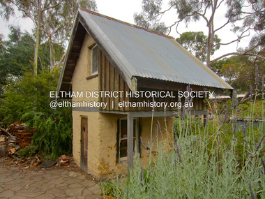 Eltham District Historical Society Inc
Photograph - Digital Photograph, Jim Connor, Mudbrick cottage, 62 Bougham Street, Eltham, 23 December 2012
The mud-brick cottage and the adjacent shed at 62 Brougham Street, Eltham were built in 1969 by Peter Garner, who was in his mid-teenage years at the time. PETER GARNER MUD BRICK STUDIO AND ADJACENT SHED 62 BROUGHAM STREET ELTHAM, NILLUMBIK SHIRE https://vhd.heritagecouncil.vic.gov.au/places/55317jim connor collection, mudbrick construction, brougham steet, eltham, peter garner -
 Eltham District Historical Society Inc
Photograph - Digital Photograph, Alan King, St Andrews Hotel, 2 February 2008
The c1860 St Andrews Hotel, with the c1930 additions, and the Canary Island Palm, and the surrounding site to the title boundaries are historically, socially and aesthetically significant to the Shire of Nillumbik. The St Andrews Hotel is historically significant because it may have given its name 'St Andrews' to the town (another suggestion is that the name came from St Andrews church) and for its connection to Ewen Hugh Cameron (1831-1915) the prosperous local farmer, member of the Eltham Roads Board/Shire Council and local MP. It is also significant as the oldest hotel building in the former Shire of Eltham, as one of the few surviving buildings connected with the Caledonian goldfields era and as one of a handful of early structures to have survived the 1960s bushfires; the additions and alterations to the hotel reflect its long life. The hotel is socially significant because it has served as an important meeting place for more than 160 years. The Canary Island Palm is historically significant as a rare example of exotic tree planting in this rural area. The tree is aesthetically and historically significant as a local landmark and for its contribution to the streetscape and landscape value. Covered under Heritage Overlay, Nillumbik Planning Scheme. Published: Nillumbik Now and Then / Marguerite Marshall 2008; photographs Alan King with Marguerite Marshall.; p71This collection of almost 130 photos about places and people within the Shire of Nillumbik, an urban and rural municipality in Melbourne's north, contributes to an understanding of the history of the Shire. Published in 2008 immediately prior to the Black Saturday bushfires of February 7, 2009, it documents sites that were impacted, and in some cases destroyed by the fires. It includes photographs taken especially for the publication, creating a unique time capsule representing the Shire in the early 21st century. It remains the most recent comprehenesive publication devoted to the Shire's history connecting local residents to the past. nillumbik now and then (marshall-king) collection, st andrews hotel -
 Greensborough Historical Society
Map, Melbourne and Metropolitan Board of Works. Survey Division, MMBW, Yarra 2500 / 13.23. Plenty, Happy Hollow, 1979_03
Melbourne and Metropolitan Board of Works. Yarra 2500 [base map] 13-23. Plenty / Happy Hollow. Parishes of Morang 3183, Nillumbik 3310 and Keelbundora 2856. Municipalities of Diamond Valley 257 and Whittlesea 239. Prominent streets include: McLaughlans Lane and Happy Hollow Drive. Includes Janefield Colony Reserve.MMBW Map in 1:2500 [scale] series. Cream parchment with green tape reinforcing on edges and punched holes on left edge.mmbw, melbourne and metropolitan board of works, shire of diamond valley, plenty - maps, happy hollow -
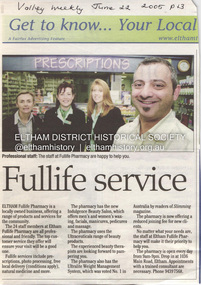 Eltham District Historical Society Inc
Document - Property Binder, 1036 Main Road, Eltham
Newspaper article: Fullife service, Valley Weekly, 22 June 2005, Description of Fullife Pharmacy services, Eltham. Newspaper article: Holistic health, Valley Weekly, 22 June 2005, Description of Nillumbik Community Health Service. Newspaper advertisement: Nibble & Bake shop, Valley Weekly, 22 June 2005.main road, eltham, shops, businesses, fullife pharmacy eltham, nillumbik community health service, nibble & bake shop eltham, tina asker -
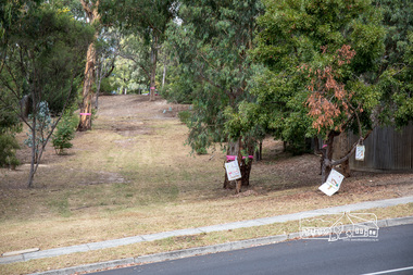 Eltham District Historical Society Inc
Photograph, Council owned Reserve running between Arthur Street and Ruskin Court, Eltham, 4 March 2018, 4/3/2018
Shows protest banners and ribbons placed by members of the community opposed to Nillumbik Council's proposal to sell this land along with 16 other reserves in the Shire. One of 17 reserves which 3,000 people rallied for at the former Shire office site on March 4th, 2018 then marched down Main Road to Luck Street.Born digital imagenillumbik shire council, parks, save community reserves, arthur street, ruskin court -
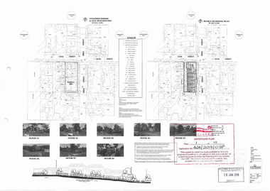 Eltham District Historical Society Inc
Document, Advertised Development Plan 424/2017/03P for 28 Luck Street, Eltham by R.P. Home Developments Pty Ltd, 29 January 2018
Former Eltham Specialist Centre Nillumbik Shire Council Advertised Application; 9 of 10 pages sourced from Eltham Community Action Group Facebook page, 21 March 2018 Buildings and works to construct (6) six dwellings and reduction of car parking requirements by not providing one visitor car space Digital image (9)eltham, eltham specialist centre, luck street, bible street, r.p. home developments pty ltd, streets -
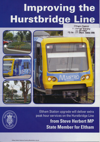 Eltham District Historical Society Inc
Folder, Hurstbridge Line Upgrade, 2010
Correspondence and information from the State Government about the Hurstbridge Line upgrade 2010. Also includes newspaper articles, Nillumbik Shire Council minutes report, map and contextual information regarding the Eltham Major Activity Centre structure Plan 2009. The main area of concern was the plan to reconfigue the Eltham stabling yard.23 documents, 62 pages of news clippings, photocopies and colour political fliersHG Folders 108 and 115harry gilham collection, railway line construction, hurstbridge line, hurstbridge railway line, eltham railway station, eltham station carpark, train stabling yard -
 Eltham District Historical Society Inc
Photograph, Fay Bridge, Book launch of Laughing Waters Road by Jane Woollard at Montsalvat, Eltham, 30 January 2016
Laughing Waters Road , the book was launched at Montsalvat in Eltham. On Saturday, January 30, 2016, Nillumbik Council launched this book. The weather was cool; just as well, considering over 500 people attended this very pleasant event where food and drink were plentiful. The Australian Government and Nillumbik Shire Council funded the book and it was designed by Wayne Rankin of North Warrandyte. The dedication page is to our very own Ranger Campbell Beardsell OAM of Parks Vic who taught Jane to be “passionate about the environment of this special place” (p260). FOWSP members Val Polley, Linda Rogan and Ken Crook contributed to the content and photos. David Wandin, Wurundjeri Elder, gave a Welcome to Country and officially launched the book after the Mayor of Nillumbik, Cr Hattam, made introductions. Jane Woollard followed with a brief outline of how she came to write the book (her very first) and read out loud the last paragraph which focuses on reconciliation and shared culture. Jane declared in her preface that the book “has been formed by attending to the connection between rivulets of memories, creeks of hearsay, rivers of tales, the meanders of local legend and the deep, still pools of the archive.” Very poetic! - Lynda Gilbert Newsletter; Friends of Warrandyte State Park March 2016, Volume 34 Number 2 Laughing Waters Road , the book was launched at Montsalvat in Eltham ON SATURDAY 30 JANUARY Nillumbik Council launched this book. The weather was cool; just as well, considering over 500 people attended this very pleasant event where food and drink were plentiful. The Australian Government and Nillumbik Shire Council funded the book and it was designed by Wayne Rankin of North Warrandyte. The dedication page is to our very own Ranger Campbell Beardsell OAM of Parks Vic who taught Jane to be “passionate about the environment of this special place” (p260). FOWSP members Val Polley, Linda Rogan and Ken Crook contributed to the content and photos. David Wandin, Wurundjeri Elder, gave a Welcome to Country and officially launched the book after the Mayor of Nillumbik, Cr Hattam, made introductions. Jane Woollard followed with a brief outline of how she came to write the book (her very first) and read out loud the last paragraph which focuses on reconciliation and shared culture. Jane declared in her preface that the book “has been formed by attending to the connection between rivulets of memories, creeks of hearsay, rivers of tales, the meanders of local legend and the deep, still pools of the archive.” Very poetic! - Lynda Gilbert Newsletter; Friends of Warrandyte State Park March 2016, Volume 34 Number 2 https://fowsp.org.au/docs/News_2016/34_02_March.pdffay bridge collection, 2016-01-30, book launch, bronnie hattam, jane woollard, laughing waters road, montsalvat, sigmund jorgensen, harry gilham, maurice hurry -
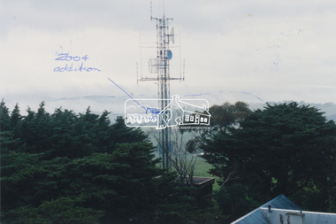 Eltham District Historical Society Inc
Photograph, View of communications tower from War Memorial tower, Kangaroo Ground, July 1998
Handwritten sketches showing additions to the Police/Emergency services communications tower in 2004. Harry Gilham noted that the cylindrical shaped object was blocking the view from the War Memorial tower to the land area and made suggestions to the Nillumbik Shire Council and CFA that it be raised to the sky area above the Mt St Leonard-Healesville range.Colour photo print 12.5 x 19 cmHandwritten notes on both sides regarding 2004 modificationskangaroo ground, shire of eltham memorial park, emergency services communications tower, harry gilham, nillumbik shire council, war memorial tower -
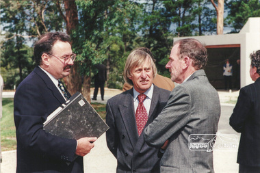 Eltham District Historical Society Inc
Photograph, Ian Jelbart (right) and Robert Marshall (centre) at the launch of the Kinloch Gardens development, 93 Arthur Street, Eltham, April 1998
Launch of the Kinloch Gardens development, 12 new double and triple storey homes along a private road in the gardens of Kinloch, a mansion set on 2.4ha in Arthur St. The launch was attended by Planning Minister Rob Maclellan and Nillumbik Shire president Robert Marshall, Architects Graeme Gunn and Ian Jelbart and approximately 100 guests.8 images; digital file only; created from scan undertaken by EDHS of a set of 26 colour 10 x 15 cm prints arthur street, eltham, graeme gunn, houses, ian jelbart, jelbart property, kinloch gardens, robert marshall, woodridge estate -
 Eltham District Historical Society Inc
Photograph, Architect Graeme Gunn with unknown guests at the launch of the Kinloch Gardens development, 93 Arthur Street, Eltham, April 1998
Launch of the Kinloch Gardens development, 12 new double and triple storey homes along a private road in the gardens of Kinloch, a mansion set on 2.4ha in Arthur St. The launch was attended by Planning Minister Rob Maclellan and Nillumbik Shire president Robert Marshall, Architects Graeme Gunn and Ian Jelbart and approximately 100 guests.1 images; digital file only; created from scan undertaken by EDHS of a set of 26 colour 10 x 15 cm prints arthur street, eltham, graeme gunn, houses, ian jelbart, jelbart property, kinloch gardens, robert marshall, woodridge estate -
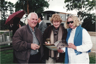
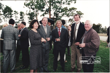 Eltham District Historical Society Inc
Photograph, L-R: Christine and Ian Jelbart, Robert Marshall, John Graves and Graeme Gunn at the launch of the Kinloch Gardens development, 93 Arthur Street, Eltham, April 1998
Launch of the Kinloch Gardens development, 12 new double and triple storey homes along a private road in the gardens of Kinloch, a mansion set on 2.4ha in Arthur St. The launch was attended by Planning Minister Rob Maclellan and Nillumbik Shire president Robert Marshall, Architects Graeme Gunn and Ian Jelbart and approximately 100 guests.8 images; digital file only; created from scan undertaken by EDHS of a set of 26 colour 10 x 15 cm prints arthur street, christine jelbart, eltham, graeme gunn, houses, ian jelbart, jelbart property, john graves, kinloch gardens, robert marshall, woodridge estate -
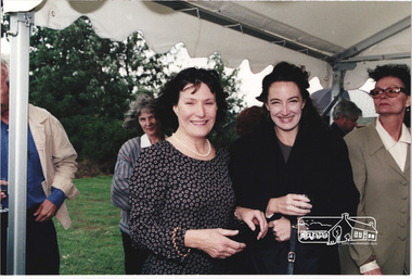 Eltham District Historical Society Inc
Photograph, Christine Jelbart (left) with two unknown women at the launch of the Kinloch Gardens development, 93 Arthur Street, Eltham, April 1998
Launch of the Kinloch Gardens development, 12 new double and triple storey homes along a private road in the gardens of Kinloch, a mansion set on 2.4ha in Arthur St. The launch was attended by Planning Minister Rob Maclellan and Nillumbik Shire president Robert Marshall, Architects Graeme Gunn and Ian Jelbart and approximately 100 guests.1 images; digital file only; created from scan undertaken by EDHS of a set of 26 colour 10 x 15 cm prints arthur street, christine jelbart, eltham, houses, jelbart property, kinloch gardens, woodridge estate