Showing 6805 items matching "river"
-
 Ballarat Heritage Services
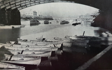
Photograph - Image, Below Princes Bridge, Melbourne
The Yarra River flows through Melbourne, the capital of Victoria. Photograph of the Princes Bridge on the Yarra River, Melbourne.melbourne, yarra river, princes bridge -
 Lakes Entrance Historical Society
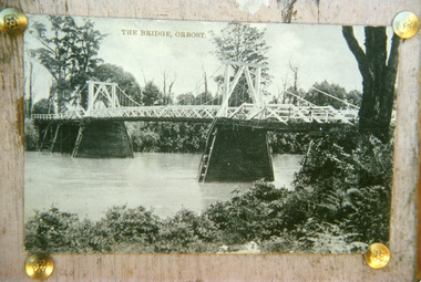
Photograph - Bridges, 1920
First bridge over the Snowy River at Orbost built 1891Black and white photographic print showing early first bridge across Snowy River thick vegetation along river banks. Orbost Victoriabridges, waterways -
 Lakes Entrance Historical Society
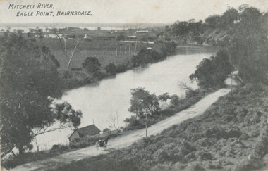
Postcard - Eagle Point bluff, silt Jetties and Jones' Bay, Eagle Point Victoria, A W Burman Bairnsdale, 1912 c
Letter on back dated Dec 30 1912 to Mrs Brewer Signed FloraBlack and white postcard showing view of Mitchell River looking east towards Eagle Point bluff and the silt Jetties and Jones' Bay small farm and buildings, hop kiln on bank opposite bluff and hop paddock. Horse and jinker on gravel road Eagle Point VictoriaMitchell River Eagle Point Bairnsdale waterways, rivers, jetties, roads and streets, transport -
 Tatura Irrigation & Wartime Camps Museum
Photograph, May, 1888
Taken by photographer for State Rivers and Water Supply Commission.Medium sized black and white photograph. Wooden trestles across river - coffer dams on left fallen timber foreground lying in water of the river bed.goulburn weir, victorian state rivers and supply commission -
 Lakes Entrance Historical Society
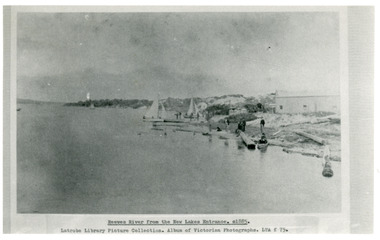
Photograph - Reeves River
Black and white photograph showing building, boats, and workmen at site of proposed New Entrance. View of Reeves River, later called Cunninghame Arm, looking east towards natural entrance. Lakes Entrance VictoriaReeves River from the New Lakes Entrance 1885c waterways, public works -
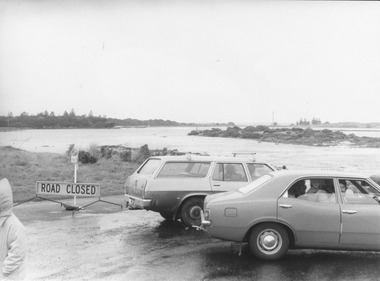 Port Fairy Historical Society Museum and Archives
Photograph
Causeway over river to Griffith Island after storm 1975 . Southwest passageblack and white photograph of Cars parked at causeway during stormCauseway over river 16/05/1975southwest passage, causeway, storm, 1975, griffith island -
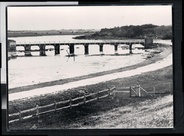 Port Fairy Historical Society Museum and Archives
Photograph - Photograph,copy
Port Fairy Moyne river bridgeBlack and white photograph of Moyne river traffic bridgebridge, moyne river, low tide, griffith street -
 Sunbury Family History and Heritage Society Inc.
Photograph, Bulla Bridge, 12 July 1944
The photograph was taken looking across the Deep Creek valley with the three-arched stone bridge spanning the river.A black and white photograph with a white border of a deep river valley with a three-arched bridge spanning a river. A gum tree is in the foreground. -
 Chelsea & District Historical Society Inc
Photograph - Patterson River, Rail and Road Bridge, c 1910
The first bridge over the river was built in the early 1880's, prior to this it was a pontoon bridge.Black and white photo of the wooden road bridge (Point Nepean / Nepean Highway), over Patterson River, Carrum near the mouth of the river. patterson river, road bridge, rail bridge, chelsea, transport, patterson river bridge, carrum bridge -
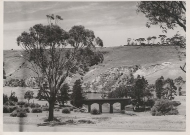
 Orbost & District Historical Society
black and photograph / postcard, 1.4.1908
This postcard was sent to Annie Gilbert (Mrs John Gilbert) of Tullagoota, Orbost. It was written by "Grace", probably her sister, Grace Cameron Annie Gilbert was the daughter of John Cameron who selected the first land on the Snowy River flats. This is a photograph of the original Orbost / Snowy River Bridge , a suspension bridge which opened in 1893. It has been taken when the Snowy River was in flood. It is similar to other photographs held in The State Library, Victoria. The Snowy River Mail and Tambo and Croajingolong Gazette Sat 12 Aug 1893 records the opening of this bridge as "the most important public event that has yet been commemorated in Eastern ......The Messrs McLeod, with whom the first settlement of this district is generally associated, took up their residence on the eastern bank of the Snowy River about the year 1841 or 42. The late Mr W. Roadknight and Mr T. T. Stirling took possession of the territory on the western side of the Snowy about 35 years ago. During the occupation of the country by cattle owners, very little progress was made in the way of roads and bridges, and except to the hardy and lexperienced bushman, it might have been generally regarded as inaccessible. About the year 1877, however, the late Mr James Robertson eldest son of Mr James Robertson, of Lochend farm, selected land now occupied by his father, about four miles from Orbost on the west bank of the river, Mr John Cameron visited the. district shortly after a .tour of inspection and returned later with his brothers, James and Alick Gameron, but found that during their absence Mr Ernest Watt had found his way on the scene and pegged out a selection, thus anticipating the advent of the Camerons by about 12 hours. We understand that a Mr Kidd, who selected the property now occupied by Mr W. J. Ross, at Pumpkin Point, was one of the earliest batch of settlers.........."This item is associated with Annie Gilbert (nee Cameron) reported to have been the first white girl to be born in Orbost. It is a pictorial record of the suspension bridge over the Snowy River which has since been replaced twice.A faded black / white postcard of a bridge across a river. There are cattle in the river and the banks are tree-covered.on back - a hand-written letter addressed to Mrs J. Gilbert Tullagoota Orbost.cameron-annie suspension-bridge-orbost snowy-river-orbost -
 Hume City Civic Collection
Photograph
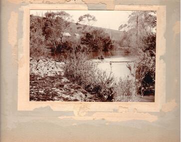
Could be river bend in Jackson's Creek.A sepia photograph mounted on a cream frame of a river bend. There is a small cottage on the LHS of the photo partly covered with gum trees. Exotic trees are growing on the RH river bank.rivers, houses, jackson's creek, landscapes, george evans collection -
 Charlton Golden Grains Museum Inc
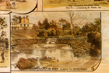
Photograph - Lithograph, Rider & Mercer, Views of Charlton
East Charlton weir across the Avoca River about 60 metres upstream from Bridge.Colour photograph of a portion of the "Views of Charlton" Lithograph. The photo is a close up of the East Charlton Wier portion of the Lithograph.East Charlton Wier Across the River Avoca.charlton, lithograph, charlton weir, avoca river, flour mill, foreman, avoca water works trust -
University of Melbourne, Burnley Campus Archives
Plan, The Heyington Diversion
yarra, river, freeway -
 Kiewa Valley Historical Society
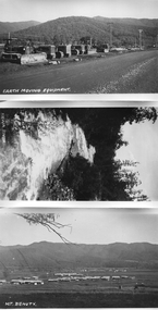
Photos - Mt Beauty and surrounds
B & W photos - Mt Beauty township; Earthmoving Equipment opposite workshops; Kiewa River; Mt Bogong view all with the titles written on the bottom left hand cornerKiewa River; Mt Bogong; Earth Moving Equipment; Mt Beauty -
 Kew Historical Society Inc
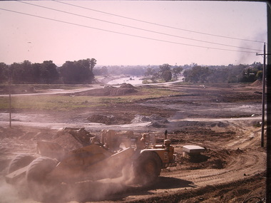
Photograph - Construction of the Eastern Freeway (F19), Ron Setford, March 1972
Ron Setford and his wife Grace Setford lived in Tanner Avenue, East Kew, from c.1946 to c.1995. A keen photographer, he recorded the changing face of Kew over a 20 year period. Apart from 30 photographs of built structures and places in Kew dating from 1960 and 1961, 145 of his 35mm colour slides chronicle the development of the F19 (later renamed Eastern) Freeway through the Yarra Valley in Kew over a five year period from c.1972 to c.1977. This important collection was donated to the Society by his granddaughter in 2025.This collection of 175 35mm slides is of local and statewide significance, owing to its subject matter, particularly the major development of road transport infrastructure during the 1970s with the construction of the Eastern Freeway. The photographer also took care to annotate and date most of his slides which enable the researcher to pinpoint temporal and spatial locations.Panoramic view of the Yarra Valley in March 1972 showing the early stages of the construction of the F19 (Eastern) Freeway. The photo shows the construction of an embankment to contain the new river course of the Yarra."Eastern Freeway / New river course preparing for embankment / Mar 72"ron setford, eastern freeway, f19 freeway -
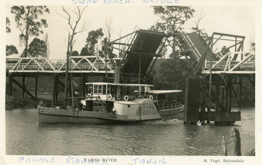 Lakes Entrance Historical Society
Postcard - P.S. Tanjil, Vogt, Stanley, 1920 c
Two copies existBlack and white postcard showing P S Tanjil passing downstream under Swan Reach Bridge on Tambo River, East Gippsland, Victoria.Paddle Steamer Tanjil Tambo River Swan Reach Bridge. S. Vogt Bairnsdaleships and shipping, waterways, bridges -
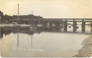 Chelsea & District Historical Society Inc
Photograph - Patterson River, Rail and Road Bridge
The first bridge over the river was built in the early 1880's, prior to this it was a pontoon bridge.Black and white photo of the road bridge (Point Nepean / Nepean Highway) and rail bridge, near the mouth of the Patterson River. Taken from the mouth of the river.patterson river, road bridge, rail bridge, chelsea, transport, patterson river bridge, carrum bridge -
Glenelg Shire Council Cultural Collection
Photograph - Photograph - Casterton, Victoria, c. 1963
SOURCED FROM CASTERTON TOWN HALL (FORMER SHIRE OF GLENELG)Black and white photo of Glenelg River Bridge at CastertonBack: 'Glenelg River Bridg at Casterton' handwritten, blue biro. Blue line, arrowed each end, drawn across photo, 3" written above line. Black number stamp.glenelg river, casterton, tourism -
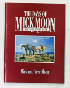 Orbost & District Historical Society
book, The Days of Mick Moon - along the Snowy River, 1988
A 47 pp book containing anecdotes of frontier life around Buchan, stories and line drawings. It has a dark red cover with the title in white print. In a frame is a painting of a stockman adjusting the saddle on a brown horse with white horse standing next to it. There are two black and white dogs lying nearby. The setting is the alpine region of Victoria. the book was authored by Mick and Vere Moon.snowy-river moon-mick buchan -
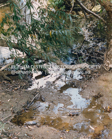 Eltham District Historical Society Inc
Photograph (Item) - Print, Craig Price, Trees, Water And Beer Bottles - River Bank Eltham, 1988
Craig Price 1988 Entrant No. 148 Ref: Series 34, Items 37, 38, 109, 110 No negative (or missing) SHIRE OF ELTHAM COMMUNITY PHOTOGRAPHIC SURVEY Photography is an artform which many of us practice, sometimes purely for artistic pursuit, sometimes to record the people and events in our lives. In 1988, as part of a local Bicentennial project, the Shire of Eltham conducted the Eltham Community Photographic Survey. Up to 100 entries were to be selected by a panel of photographers for entry into the Eltham Photographic Survey Exhibition. Entries had to be submitted by May 13, 1988. Entrants whose images were selected for the exhibition were contacted and requested to further submit an entry form providing entrant’s name, area of residence, age, and proposed captions. These details were then used to produce labels for the exhibition mounts. Where negatives had not been supplied, these were requested to support the display of printed enlargements mounted on 10” x 8” cardboard. The mounted prints were made available post exhibition for sale at $8.50 each for colour prints and $7.00 for B&W prints. Residents in the Shire were invited to collect a free roll of film and take a photograph of what they either liked or did not like about the area. A total of 160 entrants submitted multiple entries for the exhibition. Of those selected for exhibition, entrants ranged in age from 9 to 70 years. All custom colour and black and white printing for the exhibition was completed by Wattle Studios of Eltham. The Eltham Photographic Survey was jointly auspiced by the Shire of Eltham and Wattle Studios, of 953 Main Road, Eltham. The project was greatly assisted by: • David McRitchie, Media Studies Lecturer Victoria College, Rusden Campus. • Ian and Annette Toohill of Wattle Studios • Tracy Naughton, Eltham Community Arts Officer • Neville Emerson Pty. Ltd. • Superior Press, Eltham • Kodak Australasia Pty. Ltd. • Agfa Gevaert Ltd. • Townsend Colourtech Pty. Ltd. • The Australian Bicentennial Authority • Eleanor Bowers, Secretary, Eltham Arts Council The exhibition was placed on display in the Woolworths Arcade, Eltham between Monday June 6th and Saturday June 11, 1988. It was also intended to hold the exhibition at a venue in the Shire’s North Riding from Monday, June 20 to Friday June 24. It was then displayed at the Were Street Theatre, Montmorency from Friday, June 24 to Thursday, July 7. Series 34: Eltham Community Photographic Survey 1988 - Prints & Documentation Series consists of 117 photographs of Shire scenes taken by members of the community. Items I - 41 are larger photographs mounted on card, which were exhibited. Items 42 - 117 are unmounted copies, alternative takes and other entries. Corresponding negatives contained in Series 35: Eltham Community Photographic Survey 1988 – Negatives which consists of 267 colour and B&W negatives and one colour slide of Shire scenes taken by members of the community. The negatives are arranged by the entrant number of the photographer. The Eltham Community Photographic Survey collection is significant to the local community as it was curated by the local community - ordinary people of all ages - representing what they liked and did not like in the area where they lived. It represents an unfiltered representation of the Shire of Eltham as it was in 1988. It also represents one of many projects as part of the national programme of events and celebrations to commemorate the bicentenary. It is a time capsule of life in the 1980s of this urban and rural municipality in Melbourne's north. Front: Entrant No. and name on printed label Rear: Entrant No., name and address on printed label; also 'Series 34' and the 'Item No.' in pencilshire of eltham archives, bicentennial project, eltham, eltham community photographic survey, eltham photographic survey exhibition, series 34, series 35, craig price, yarra river -
 Eltham District Historical Society Inc
Photograph (Item) - Print, Mathew Wakefield, Untitled (Yarra River Scene), 1988
Mathew Wakefield 1988 Entrant No. 40 Ref: Series 34, Items 87, 88 The photographer noted that in a sad indictment of the local community, this German Shepherd dog and another had been abandoned by their owners to scavenge through the bins and chase the drunks around the lake at dawn. Both dogs were impounded and the owners never claimed them. As a consequence they were eventually both put down. SHIRE OF ELTHAM COMMUNITY PHOTOGRAPHIC SURVEY Photography is an artform which many of us practice, sometimes purely for artistic pursuit, sometimes to record the people and events in our lives. In 1988, as part of a local Bicentennial project, the Shire of Eltham conducted the Eltham Community Photographic Survey. Up to 100 entries were to be selected by a panel of photographers for entry into the Eltham Photographic Survey Exhibition. Entries had to be submitted by May 13, 1988. Entrants whose images were selected for the exhibition were contacted and requested to further submit an entry form providing entrant’s name, area of residence, age, and proposed captions. These details were then used to produce labels for the exhibition mounts. Where negatives had not been supplied, these were requested to support the display of printed enlargements mounted on 10” x 8” cardboard. The mounted prints were made available post exhibition for sale at $8.50 each for colour prints and $7.00 for B&W prints. Residents in the Shire were invited to collect a free roll of film and take a photograph of what they either liked or did not like about the area. A total of 160 entrants submitted multiple entries for the exhibition. Of those selected for exhibition, entrants ranged in age from 9 to 70 years. All custom colour and black and white printing for the exhibition was completed by Wattle Studios of Eltham. The Eltham Photographic Survey was jointly auspiced by the Shire of Eltham and Wattle Studios, of 953 Main Road, Eltham. The project was greatly assisted by: • David McRitchie, Media Studies Lecturer Victoria College, Rusden Campus. • Ian and Annette Toohill of Wattle Studios • Tracy Naughton, Eltham Community Arts Officer • Neville Emerson Pty. Ltd. • Superior Press, Eltham • Kodak Australasia Pty. Ltd. • Agfa Gevaert Ltd. • Townsend Colourtech Pty. Ltd. • The Australian Bicentennial Authority • Eleanor Bowers, Secretary, Eltham Arts Council The exhibition was placed on display in the Woolworths Arcade, Eltham between Monday June 6th and Saturday June 11, 1988. It was also intended to hold the exhibition at a venue in the Shire’s North Riding from Monday, June 20 to Friday June 24. It was then displayed at the Were Street Theatre, Montmorency from Friday, June 24 to Thursday, July 7. Series 34: Eltham Community Photographic Survey 1988 - Prints & Documentation Series consists of 117 photographs of Shire scenes taken by members of the community. Items I - 41 are larger photographs mounted on card, which were exhibited. Items 42 - 117 are unmounted copies, alternative takes and other entries. Corresponding negatives contained in Series 35: Eltham Community Photographic Survey 1988 – Negatives which consists of 267 colour and B&W negatives and one colour slide of Shire scenes taken by members of the community. The negatives are arranged by the entrant number of the photographer. The Eltham Community Photographic Survey collection is significant to the local community as it was curated by the local community - ordinary people of all ages - representing what they liked and did not like in the area where they lived. It represents an unfiltered representation of the Shire of Eltham as it was in 1988. It also represents one of many projects as part of the national programme of events and celebrations to commemorate the bicentenary. It is a time capsule of life in the 1980s of this urban and rural municipality in Melbourne's north. Rear: Entrant No., name and address in blue ink; also 'Series 34' and the 'Item No.' in orange inkshire of eltham archives, bicentennial project, eltham, eltham community photographic survey, series 34, series 35, film - fuji 100, mathew wakefield, scan - 35mm negative, yarra river -
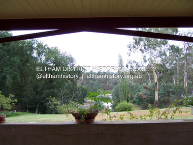 Eltham District Historical Society Inc
Photograph - Digital Photograph, Marguerite Marshall, View of the Yarra River from 'Worlingworth', 10-26 Banoon Road, Eltham, 30 January 2006
'Worlingworth', Eltham, home of noted anthropologist the late Professor Donald Thomson and his wife Dorita Thomson. Covered under Heritage Overlay, Nillumbik Planning Scheme. Published: Nillumbik Now and Then / Marguerite Marshall 2008; photographs Alan King with Marguerite Marshall.; p127This collection of almost 130 photos about places and people within the Shire of Nillumbik, an urban and rural municipality in Melbourne's north, contributes to an understanding of the history of the Shire. Published in 2008 immediately prior to the Black Saturday bushfires of February 7, 2009, it documents sites that were impacted, and in some cases destroyed by the fires. It includes photographs taken especially for the publication, creating a unique time capsule representing the Shire in the early 21st century. It remains the most recent comprehenesive publication devoted to the Shire's history connecting local residents to the past. nillumbik now and then (marshall-king) collection, banoon road, donald thomson, dorita thomson, eltham, worlingworth -
 Eltham District Historical Society Inc
Photograph, Fay Bridge, Yarra River near Laughing Waters Road, Eltham, April 2016
fay bridge collection, 2016-04, laughing waters, yarra river -
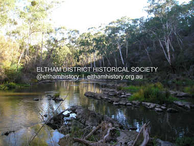
 Eltham District Historical Society Inc
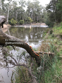
Photograph, Fay Bridge, Yarra River near Laughing Waters Road, Eltham, June 2016
Viewed from the Warrandyte side opposite the Eel trap at Killeaveyfay bridge collection, 2016-06, laughing waters, yarra river -
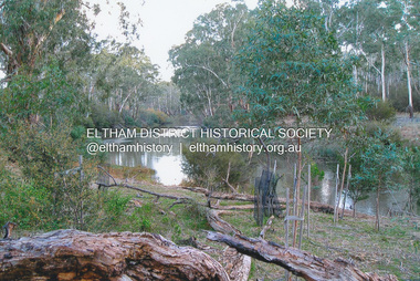
 Eltham District Historical Society Inc
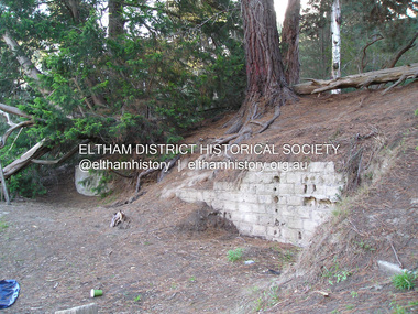
Photograph, Fay Bridge, Ruins at Griffith Park, Eltham near the Yarra River, June 2016
Griffith Park is the former property and home of Cr Fred Griffith in the 1950sfay bridge collection, 2016-06, griffith park, ruins -
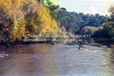
 Eltham District Historical Society Inc
Photograph, Fay Bridge, Yarra River near the eastern boundary of former Warrandyte Aboriginal Reserve, North Warrandyte, 11 August 2023
Accessed via The Boulevard, North Warrandytefay bridge collection, aboriginal reserve, north warrandyte, warrandyte aboriginal reserve, 2023-08-11 -
 Eltham District Historical Society Inc
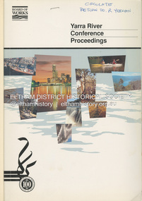
Book, Melbourne Metropolitan Board of Works, Yarra River Conference Proceedings, 1991
Conference staged by the Board of Works to present a range of papers examining the river's environment, recreational uses, natural resources, development, commerce and land use. Conference delegates included representatives from Eltham Shire Council and was held in April 1991. Session 1 Heritage and Environment: Flora and fauna / Paul Gullan. -- Geology and topography / Brian Finlayson. -- Aboriginal culture / Margaret Gardiner. Session 2 History. Session 3: Management plans and policies : overview of responsibilities / Dr Colin Leigh. --Role of the media / Peter Cole-Adams. -- Urban development / Paul Jerome. -- Port of Melbourne area / Leigh McKay. -- Recreation / Ken Marriott. Session 4: Perspectives - the current view. Session 5: Issues, challenges, potential solutions.non-fictionConference staged by the Board of Works to present a range of papers examining the river's environment, recreational uses, natural resources, development, commerce and land use. Conference delegates included representatives from Eltham Shire Council and was held in April 1991. Session 1 Heritage and Environment: Flora and fauna / Paul Gullan. -- Geology and topography / Brian Finlayson. -- Aboriginal culture / Margaret Gardiner. Session 2 History. Session 3: Management plans and policies : overview of responsibilities / Dr Colin Leigh. --Role of the media / Peter Cole-Adams. -- Urban development / Paul Jerome. -- Port of Melbourne area / Leigh McKay. -- Recreation / Ken Marriott. Session 4: Perspectives - the current view. Session 5: Issues, challenges, potential solutions.yarra river, melbourne -
 Eltham District Historical Society Inc
Document - Property Binder, Plenty River Bridge, Main Road, Lower Plenty
Extracts Heidelberg Council Minutes re Plenty Bridge, 3 September1862, 10 May 1865, 22 May 1865, 5 June 1865 , 10 October1866, 14 November1866, 13 February 1867.main road, property, houses, shops, businesses, plenty bridge -
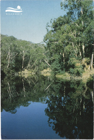 Eltham District Historical Society Inc
Postcard - Photograph, Shire of Nillumbik, Yarra River, southern boundary of the Shire of Nillumbik, c.2010
Nillumbik Shire Council c.2010 Arts Environment Heritagepostcard, birrarung, shire of nillumbik, yarra river -
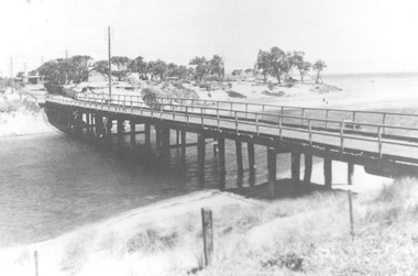
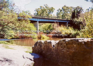 Eltham District Historical Society Inc
Photograph - Colour Print, Warrandyte Bridge over Yarra River, c.1987
Boundary for the Shire of Eltham and now Shire of Nillumbikwarrandyte bridge, yarra river