Showing 3063 items matching "scales"
-
 Glenelg Shire Council Cultural Collection
Photograph - Photograph - aerial view of Portland, c. 1954
Black and white aerial photograph of coastline around Portland. Black border, scale all sides, 5 rows of 3 't' at regular intervals. Three quarters ocean, one quarter land. See Other InformationFront: '820 -48' - handwritten, white, border 'RUN 6' 'PORTLAND', printed, white, borderaerial photography, central portland, portland harbour, south west coastline -
Glenelg Shire Council Cultural Collection
Photograph - Photograph - aerial view of Portland, c. 1954
Black and white aerial photograph of coastline around Portland. Black border, scale all sides, 5 rows of 3 't' at regular intervals. Both sides of headland can be seen. 60/40 ocean to landFront: '784 - 150 - handwritten, white, border 'RUN 7 A PORTLAND', printed, white, borderaerial photography, central portland, portland harbour, south west coastline -
 Federation University Historical Collection
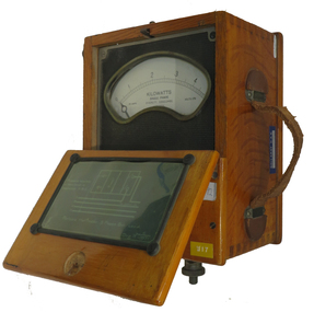
Instrument - Electrical Instrument, Everett AC Wattmeter, 1923
Would have been used by staff and students of electrical Engineering at the School of Mines, Lydiard St. campus up until the start of the Mount Helen campus E building third floor. The meter would have had limited use in classes until 2009. This Wattmeter became part of the historical collection in 2011 after the movement of Engineering out of the E building. In working condition and a good example of early 20th century electrical instruments.A polished natural timber case with partial flip top lid and leather carry handle, housing a single phase AC Wattmeter, rated at 170 volts , 30 amps Scale 0 to 5 kilowatt. Serial no :210088Schematic diagram on inside lid showing how to connect the Wattmeter to measure a 3 phase balanced load. Paper sticker on top "1/92" Information for voltage and current ranges painted with white paint on left hand side by Voltage terminals Voltage terminals labelled A and N Also white on black "W8" on same surface Aluminium plate "67" on right hand side near current terminals which are engraved To A and Ti A to indicate current flow direction Aluminium sticker with Ballarat CAE Electrical Engineering by carry handleeverett instruments, single phase, wattmeter, electrical, scientific instruments -
Bendigo Historical Society Inc.
Map - CAMPBELL COLLECTION: BENDIGO AND DISTRICT MAPS
Map. Eaglehawk, Parishes of Huntly and Nerring. Scale 20 chains to 1 inch. Total area 6211 acres. Eaglehawk Kerang Railway, to Epsom 2 miles. Manure Depot. (number 390 in map cupboard 1)map, bendigo, allotments -
Bendigo Historical Society Inc.
Map - CAMPBELL COLLECTION: BENDIGO AND DISTRICT MAPS, 9-4-29
Map. Campaspe, Parish of Kimbolton, Scale 20 chains to 1 inch. Total area 4117 acres, Campaspe River, Prepared in W.P.B. by W.J.Galbraith from Parish and Assessment Plans. (number 384 in map cupboard 1)W.J.Galbraithmap, bendigo, agricultural lands -
Bendigo Historical Society Inc.
Map - CAMPBELL COLLECTION: BENDIGO & DISTRICT MAPS, 14-6-29
Map. Eppalock, Sedgwick and Strathfieldsaye. Scale 20 chains to 1 inch. Total area 3972 acres. Prepared in W.P.B. from Assessment Plan and Parish Plans. H.A. Darby. (number 378 in map cupboard 1)H.A.Darbymap, bendigo, agricultural lands -
 National Vietnam Veterans Museum (NVVM)
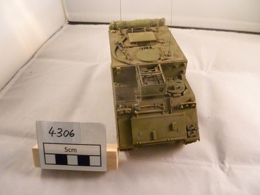
Model - Model, APC M577
Scale model of a Armed Personnel Carrier (APC) variant with additional headroom and aux motor to provide power when it is stationary. It carried additional radios and crew and was used for artillery and signals. M.577 colour is olive green.armoured personnel carrier, model, command post vehicle -
 National Vietnam Veterans Museum (NVVM)
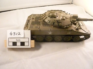
Model - Model, M551 Sheridan tank
A scaled model of an olive green US M551 Sheridan tracked tank which is closed up. there are no crew on it.There is a white US Army star on the side of the tank and also the top of the turret. The colour of the tanks is olive green.White US Army star on turret and side.model, tank -
Bendigo Historical Society Inc.
Document - MAP INDEX SHEETS, No dates on item
Map index sheets for Military survey Inch to the Mile scale maps.Covering Victoria , Tasmania, Northern Territory,Queensland and New South Wales. There are Four sheets numbered 9156 a, b , c and d. These are photocopied sheets, NOT originalsdocument, map index sheets, inch to the mile index sheets -
 Ballarat Tramway Museum
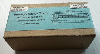
Model - Model Bendigo Birney Tram, John Eastaff, c1990
Model of a Bendigo Birney tram prior to the painting of the safety stripes by the SEC during the 1960s. Not fitted with a trolley pole. The sheet gives the story of the tram in Adelaide and Bendigo and colour schemes. The Tenshodo bogie would have enabled the tram to be motorised. Made by John Eastaff Model (JEM) of Adelaide.Demonstrates an model kit that represented the Bendigo Birney trams.Model of Bendigo Birney tram by JEM Models, comprising cardboard box, cast metal parts and instructions. HO Scale. In box as received from the donor is a Tenshodo WB 24.5 motorised bogie or wheel set or truck.models, tramcars, bendigo, birney tramcars, jem models, john eastaff models -
 Surrey Hills Historical Society Collection
Photograph, Mr Duus fruit shop display in Union Road, Surrey Hills
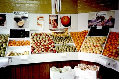
Mr Duus of Union Road, Surrey Hills was a butcher and greengrocer Note the correct spelling is "DUUS". A 1965 calendar from Duus Brothers is in vertical file under "butchers". Anthony Paul, Edward William and Alan Edward Duus were all butchers. Trevor William Duus was a carrier. In 1980 they all lived in Croydon.Interior of greengrocer shop. Displays of fruit, apples, bananas, oranges, polystyrene boxes of onions, lettuce. Scales suspended from ceiling. Brick walls with posters of fruit and rolls of plastic bags attached to front of display boxes.shops, greengrocer, posters, union road, surrey hills, duus brothers, tony duus, anthony duus -
University of Melbourne, Burnley Campus Archives
Plan, Proposed Stores & Garage Renovations, 1997
Burnley Development Site for Amrad Operations Pty. Ltd. By Johnston Merat Kurdiovsky Pty. Ltd. Dated March 1997. Scale 1:100. (1) Site Improvements Plan. (2) Elevations - Building & Fence Treatment.amrad, burnley, stores, garages, johnston merat kurdiovsky p/l -
 University of Melbourne, Burnley Campus Archives
Plan, Survey: Site 1 - Front Lawn, Main Building, 1985
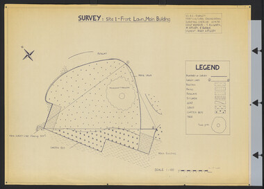
Plan of Front Lawn area with legend. V.C.A.H - Burnley Horticultural Engineering Surveying Exercise dated 10.09.1985. Group Members: T. Allworth, M. Appleby, B Barker (Student: Mary Appleby). Scale 1:100.vcah, lawns -
 Bendigo Historical Society Inc.
Map - SNOB'S HILL - PLAN OF SNOB'S HILL AREA
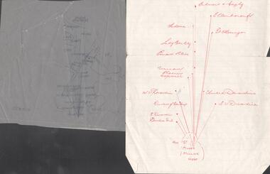
Plan drawn on tracing film of sand heap, dams, trig point and mines. Some un-named streets are also drawn in. Piece of notepaper has mines drawn in on a larger scale. Notes prepared by Albert Richardson.map, bendigo, goldfields, snob's hill, plan of snob's hill area, new st mungo mullock heap, duchess trib, s devonshire, duchess of edinburough, w u devonshire, hopewell, phoenix, unicorn, princess alice, lady barkly, sadowa, e u devonshire, united devonshire, l?, ellenborough, belmont & saxby, snob's hill -
 Bendigo Historical Society Inc.
Plan - MARKS COLLECTION: FORTUNA PLANS
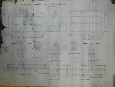
Copy of Plan: on top of plan 'Additions to Fortuna Villa for Geo Lansell Esq, scale 8 feet to one inch' Drawings of additions: ground plan, garden plan, second and third floor plan (mainly elevations).buildings, house, fortuna villa -
University of Melbourne, Burnley Campus Archives
Plan - Student Work, Grey Street Residence, December 2013
student work, assignment, landscape design, st kilda, b. terry, 3 generations -
 Kiewa Valley Historical Society
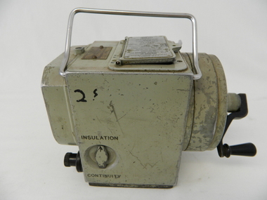
Tester Direct Current, mid 1900's
This tester was used between 1950 and 1980's. As part of the Occupation, Health and Safety requirements, equipment used to monitor the performance of electricity producing generators, regularly, hand held testers were used to check the insulation and the "earth" pin were up the the required operational levels. As the generators and their ancillary monitoring equipment was spread over a large area and cumbersome to service small hand held devices were required. These had to always be safe for the user to operate. A selected range of high quality meters were recalibrated every two years in the Meter and Calibration Laboratory at Yarraville(near Melbourne) This meter is very significant to The Kiewa Hydro Electricity Scheme because it was an integral part of maintaining the electricity producing water driven generators of the power stations. The reason why this meter was so essential is that provided the safety check on equipment used to monitor each Hydro Generator that they were complying within the grid network parameters. Grid parameters are set so that if there is an electrical fault on the system, that fault can be attended to with a very small change in the output stability of each generator. It is essential that the voltage of the network remain within the set limits. Generators are at Dartmouth, Mackay, Clover, West Kiewa, Yarrawonga, Cain Curran and three Power Stations in the Thornton area.This hand driven current generator produces 500 volts by winding the handle(on funnel curved side) to keep the voltage constant(one minute per test). The whole body is made from caste aluminium. One of the functions of this meter is to test the isolation resistance of any equipment being tested. This is to see if that equipment is safe to handle(no electrical shocks). The second function is to test the earth pin of any portable electrical equipment. The turn key on one side can direct which function is required(marked insulation or continuity). On the top side(enclosed in a glass fronted marked scale) is a continuity scale(top) and an insulation scale(bottom). This is covered , when not in use by "flip up" lid with manufacturer's details and name of the instrument. Opposite the winder are two screw tight knobs. One marked earth(left side) and one marked line(right side). On the top and next to the glass windowed scales in a post manufacture SEC Vic equipment equipment ID number. For carrying purposes there is chromed steel (fold together) handle.The bottom of the unit has two metal "feet" 150mm long by 114mm wideManufacturer's details on top side "MEG" underneath "INSULATION AND CONTINUITY TESTER" below this "constant 500 VOLT pressure" below this "REGISTERED MEG MEGGER TRADE MARK" below this "REG DESIGN NO. 690326" below this "UNITED KINGDOM PATENT Nos. 193746, 197178, 198182, 202062, 202398, 204649, 350715" below this "SUPPLIED BY THE GENERAL ELECTRIC Co. Ltd OF ENGLAND" below this "MAGNET HOUSE, KINGSWAY LONDON W.C.2" 'sec vic kiewa hydro scheme, alternate energy supplies, alpine feasibility studies temperature, rainfall -
 Kiewa Valley Historical Society
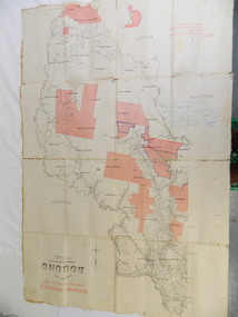
Map - Kiewa Valley, County Map of Bogong, 27/11/1905
This map has been owned by the Ryder Family of the Kiewa Valley for possibly over 100 years (1905?). It was used when the family mustered and maintained cattle on their grazing lease on the Bogong High Plains. Obviously a field map used on these occasions.This map was used by the Ryder Family who lived in the Kiewa Valley and who grazed cattle on their lease on the Bogong High Plains during summer.Showing reserves Under the Forest Act of 1907. This is a paper map which has been mounted or glued on pink and cream floral cotton. It is obvious by its poor condition that it has been used outdoors in the field. It is not in very good condition as it has been folded 4 times (8 divisions) and it is badly worn and cracked in the creases.Photo Lithographed at the Department of Lands and Surveys by T.E.McGauran 27/11/05 Price 1/3d. Scale - 2 miles to an inch. F.S. Hilcke Oct. 2nd 1905.department of lands and surveys map; ryder family; bogong high plains -
 Clunes Museum
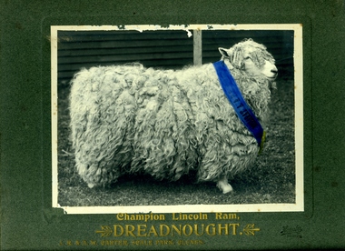
Photograph
PHOTOGRAPH OF A CHAMPION LINCOLN RAM - "DREADNOUGHT" IN GOLD LETTERING ON THE CARDBOARD MOUNT: CHAMPION LINCOLN RAM "DREADNOUGHT" J.R. AND A.W. CARTER "SCALE PARK" CLUNES ON THE RIBBON AROUND THE NECK OF THE RAM: "BALLARAT A P & S"local history, photography, photographs, carter family -
 Friends of Kurth Kiln
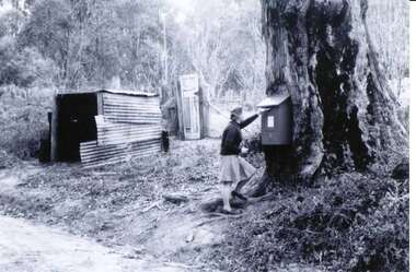
Photograph of Red Letter Box, Photograph taken ca 1976
Although the Beenak Post Office officially closed on 31 August 1951, the Mail Box continued to be used until 1976. The history of Beenak (the town that never was) is part of the Yarra Valley Ranges, and this picture tells the story of the historic MailboxBlack and White Picture of the original Beenak Post Office Letter Box, used for collecting mail during the Beenak Sawmilling operations. The Friends of Kurth Kiln have errected a Commemorative Plaque on site next to the huge gum tree that still carries the scar where the the mail box had been mounted. A full scale replica of the box has been fitted to the shed at Kurth Kiln, made and painted by Henk Bouck under the supervision of ex PMG officer John Waghorn beenak, post office -
 Ballarat Diocesan Historical Commission
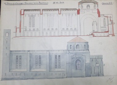
sketch, Architectural rendering for new St Patrick's Cathedral Ballarat
Rendering of proposed new cathedral for Ballarat by J. C. Hawes but never executed. Hawes designed many church buildings in Australia, West Indies, USA and UK. This image is one of a large suite of plans and drawings held in the archive.One of a series of large format sketches and proposed plans for a new cathedral at Ballarat by architect priest J.C.Hawes in 1944.Captioned St Patrick's Cathedral Ballarat, Victoria Australia 1/8 Inch Scale - Drawing No 2- and signed Lower Right John C Hawes Architect 1944. -
 Port Melbourne Historical & Preservation Society
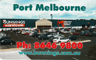
Card - Bunnings Warehouse magnet Business Card, c.2015
Bunnings Warehouse, Port Melbourne, opened in 1994. It was the first large scale hardware store in the Port Phillip area.Business card in form of a fridge magnet with picture of Bunnings Port Melbourne as a background.business and traders - hardware -
 Bendigo Military Museum
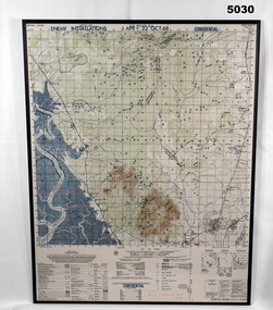
Map - MAP, MOUNTED, US Army 1966, Map information as of 1965
Map - colour map titled "XA BINH BA, VIETNAM" Scale 1:50,000. Map depicts "ENEMY INSTALLATIONS 1 APR - 22 OCT 68, CONFIDENTIAL" Map mounted on sheet of timber, sealed with a clear varnish.mapping, vietnam war -
Glenelg Shire Council Cultural Collection
Photograph - Photograph - aerial view of Portland coastline, c. 1954
Black and white aerial photograph of coastline around Portland. Black border, scale all sides, 5 rows of 3 't' at regular intervals. Mostly ocean, small area of land top left. See Other Information.Front: '820 - 47' - handwritten, white, border 'RUN 6' 'PORTLAND', printed, white, borderport of portland archives, aerial photography, portland harbour, south west coastline -
Glenelg Shire Council Cultural Collection
Photograph - Photograph - aerial view of Portland, c. 1954
Black and white aerial photograph of coastline around Portland. Black border, scale all sides, 5 rows of 3 't' at regular intervals. Half ocean, half land, separated by beach, further left than 8472Front: '607 - 91 ' - handwritten, white, border 'RUN - 6 PORTLAND', printed, white, borderaerial photography, central portland, portland harbour, south west coastline -
Glenelg Shire Council Cultural Collection
Photograph - Photograph - aerial view of Portland, c. 1954
Black and white aerial photograph of coastline around Portland. Black border, scale all sides, 5 rows of 3 't' at regular intervals. 75/25 land to ocean. Further left than 8475, ?end of beach.Front: '607 - 94 ' - handwritten, white, border 'RUN - 6 PORTLAND', printed, white, borderaerial photography, central portland, portland harbour, south west coastline -
Glenelg Shire Council Cultural Collection
Photograph - Photograph - aerial view of Portland, c. 1954
Black and white aerial photograph of coastline around Portland. Black border, scale all sides, 5 rows of 3 't' at regular intervals. Curved section of coastline top right corner. 90/10 ocean to landFront: '784 - 154'- handwritten, white, border 'RUN 7 A PORTLAND', printed, white, borderport of portland archives, aerial photography, portland harbour, south west coastline -
Glenelg Shire Council Cultural Collection
Photograph - Photograph - aerial view of Portland, c. 1954
Black and white aerial photograph of coastline around Portland. Black border, scale all sides, 5 rows of 3 't' at regular intervals. Right hand end of headland no longer visible. 50/50 ocean to land.Front: '784 - 151'- handwritten, white, border 'RUN A PORTLAND', printed, white, borderaerial photography, central portland, portland harbour, south west coastline -
Glenelg Shire Council Cultural Collection
Photograph - Photograph - aerial view of Portland, c. 1954
Black and white aerial photograph of coastline around Portland. Black border, scale all sides, 5 rows of 3 't' at regular intervals. Another curve in land, away from ocean. 70/30 ocean to landFront: '784 - 153' - handwritten, white, border 'RUN 7 A PORTLAND', printed, white, borderaerial photography, central portland, portland harbour, south west coastline -
Glenelg Shire Council Cultural Collection
Plan - Plan - S.S Admella Model Plans, SS 'Admella', n.d
Photocopy of model plan for lines and general arrangement of SS 'Admella'. scale 1:48. Photocopy paper is parchment style. Plan used by 'Float-a-boat' model makers for the construction of the Admella model acquired by Grant District council.