Showing 31827 items
matching south
-
 Bayside Gallery - Bayside City Council Art & Heritage Collection
Photograph, Department of Crown Lands and Survey, Victoria, Melbourne Project: Brighton, Hampton, Sandringham, 1976
The Department of Crown Lands and Survey (1857-1983) was responsible for the administration of survey and mapping and the sale, occupation and management of crown land throughout its existence. This aerial photograph shows parts of Brighton, Hampton and Sandringham and was taken on 1 December 1976brighton, department of crown lands and survey, aerial photograph, bayside, port phillip bay, map, cartographic material, hampton, sandringham, green point, sandringham yacht club, south road, beach road, hampton street, melbourne project 1976 -
 Bayside Gallery - Bayside City Council Art & Heritage Collection
Photograph, Department of Crown Lands and Survey, Victoria, Melbourne Project: Brighton and Hampton, 1976
The Department of Crown Lands and Survey (1857-1983) was responsible for the administration of survey and mapping and the sale, occupation and management of crown land throughout its existence. This aerial photograph shows parts of Brighton and Hampton and was taken on 1 December 1976. brighton, department of crown lands and survey, aerial photograph, bayside, port phillip bay, map, cartographic material, melbourne project 1976, brighton yacht club, middle brighton baths, hampton, green point, brighton beach, south road, the esplanade, hampton street -
 Ballarat Tramway Museum
Photograph - Black & White Photograph/s, Wal Jack, SEC No. 12 in 1930's colours at Gardens Loop, 6/10/1940
Black & white photo of SEC No. 12 in 1930's colours at Gardens Loop, in loop facing south. On rear in ink 'T39, Ballarat No. 12, ex Geelong No. 28, at Gardens, Ballarat, 6-10-40'. Kodak photo paper and machine stamp '4928' Set of two almost identical photographs, Photos re-imaged 18/7/2019. See image i2 for rear of photograph. N772 - 120 Negative see image i4 - the better photograph. N1126 - 512 Negative - see image i3 See abovetrams, tramways, gardens, wendouree parade , tram 12 -
 Kew Historical Society Inc
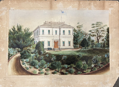
Work on paper, Madford: the property of A.S. King Esq
The Victorian-era mansion Madford in Wellington Street had several incarnations before it was finally demolished. While the precise details of its original construction have not been discovered, we know that it was originally named Elm Lodge, and that the property was offered for sale in 1863 by Thomas Mitchell, of the firm Mitchell & Bonneau, wholesale ironmongers and merchants. The house was sold in about 1873 to William Siddeley (1827-1905), who was described on the occasion of his death as ‘the father of Australian shipping’. The next owner was Arthur Septimus King (1827- 99), who renamed the house Madford after his purchase of the property in 1875. It was A.S. King for whom this artwork was completed. Following King’s death in 1899, portions of the property were sold, including to the Borough of Kew in 1905, to form the Alexandra Gardens. Then, in 1920, the house and its remaining lands were sold to the Catholic Church who opened St Anthony’s Home for Children on the site in 1922. That building was promptly demolished, and the site redeveloped circa 1976.Gift of James Pearson, 2022This fine perspective drawing of the architectural elements of Madford [formerly Elm Lodge, later St Anthony's Home for Babies] is contrasted with the freer addition in watercolour of the layout and plants of the garden facing Wellington Street. The view selected is the south-facing main facade and the west facing side. After A.S. King purchased the house in 1875, it was extended with new wings at the rear to accommodate his large family. There is no indication of these extensions in the painting so its creation must predate the renovations, and probably depicts the original building on the site."MADFORD / The Property of A. S. KING Esq"elm lodge, madford, st anthony's home for babies, houses -- wellington street -- kew (vic.), thomas mitchell, william siddeley, arthur septimus king -
 Kew Historical Society Inc
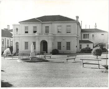
Photograph, Madford, Wellington Street, circa 1965, c. 1965
This work forms part of the collection assembled by the historian Dorothy Rogers, that was donated to the Kew Historical Society by her son John Rogers in 2015. The manuscripts, photographs, maps, and documents were sourced by her from both family and local collections or produced as references for her print publications. Many were directly used by Rogers in writing ‘Lovely Old Homes of Kew’ (1961) and 'A History of Kew' (1973), or the numerous articles on local history that she produced for suburban newspapers. Most of the photographs in the collection include detailed annotations in her hand. The Rogers Collection provides a comprehensive insight into the working habits of a historian in the 1960s and 1970s. Together it forms the largest privately-donated collection within the archives of the Kew Historical Society.‘Elm Lodge’ had a frontage to Wellington Street and extended to Cotham Road. It was renamed ‘Madford’ in 1874, after its purchase by the pastoralist Arthur Septimus King, the grandson of Philip Gidley King, third Governor of New South Wales. The Alexandra Gardens were developed on the northern section of Madford after the sale of the land to the Borough of Kew in 1905. King’s house, and the remaining garden, was sold to the Catholic Church in 1920, and subsequently developed into ‘St Anthony’s Home for Babies’ in 1922. The organisation relocated to Footscray in 1975, and the building demolished."Madford (formerly Elm Lodge) in Wellington Street Kew during the period when it was St. Anthony's Home for babies (now demolished). From the 1860s it had been the home of the King family. Harold Septimus King was one of the notable residents of Kew."madford, elm lodge, wellington street (kew), dorothy rogers -
 Kew Historical Society Inc
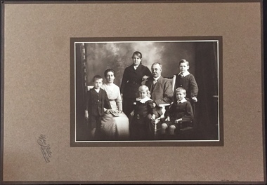
Photograph - The Weir family of Broken Hill, Sykes Studio, c.1914
An item forming part of a collection of costumes, photographs and documents relating to the Weir family who lived in the mansion originally named Illapa, 84 Princess Street, Kew, from c.1917 to 1950. This historically significant collection includes items relating to both George Weir (1866-1937) and his wife Edith Mary Weir (1867-1948). George Weir attained national prominence in the mining industry, becoming General Manager of the North Broken Hill Silver Mining Company in 1903 (later renamed North Broken Hill Mining Company 1905-12, and North Broken Hill Ltd 1912-1988), and subsequently President of the Mine Owners Association. He was to remain General Manager of North Broken Hill Ltd until his retirement in 1926.Important group family photograph, taken in Broken Hill, of the two Weir parents and their children. Another aspect of the photograph is that it is revealing about fashion and the tastes of the period.Studio portrait of George and Edith Weir and their five children, taken by a photographer of the Sykes Studio in Broken Hill, New South Wales. The members of the family are from left to right: Cecil Rigby Weir (1904-1983), Edith Mary Weir (nee Betteridge) (1867-1948), Edith Rigby Weir (1899-1981), John Rigby Weir (1910-1971), George Weir (1866-1937), Horace Rigby Weir (1907-1988), and George Rigby Weir (1901-1927). [John Rigby Weir was the father of the donor]weir collection, george weir, horace rigby weir, george rigby weir, john rigby weir, edith rigby weir, edith mary weir (nee betteridge), sykes studio -- broken hill -
 Kew Historical Society Inc
Map, MMBW, MMBW Plan No.39 Kew & Heidelberg, 1900-1910
The Melbourne and Metropolitan Board of Works (MMBW) was established by an act of the Victorian Parliament in 1890 to prepare for and to implement a sewerage and water reticulation system across what was then inner Melbourne, its surrounding and middle distance suburbs, including Kew. The MMBW was disbanded in 1991.The map collection of the Kew Historical Society has at its core the historic maps assembled and originally stored in the City Engineer's Department of the City of Kew. These include maps in a number of scales. The vast majority of maps were produced by the MMBW in the first two decades of the twentieth century, and are solid working maps, backed by linen for durability. These maps are historically significant to Kew, the City of Boroondara and to the history of the development of state utilities in Victoria. A number of the Kew maps have additional details added by former municipal officers, including the levels reached by various floods. As these were working documents, information was added to them long after the period of their initial production and distribution.Early map of part of the Borough of Kew, created in the first decade of the twentieth century, at a scale 160 ft to 1 inch. The map covers what was then the north western section of Kew, bordered on its north by Wills Street and the Kew Lunatic Asylum, in the west by the River Yarra [and the later added Yarra Boulevard] , by Princess Street in the East and Holroyd Street in the south. The map shows the extent of urban development by that time, prominent institutions and the outlines of built structures in the municipality. Contour lines were added in ink to the map at a later stage.MELBOURNE AND METROPOLITAN BOARD OF WORKS / PLAN NO. 39 / KEW & HEIDELBERGmelbourne & metropolitan board of works, mmbw maps, mmbw plans, borough of kew, cartography -
 Kew Historical Society Inc
Map, MMBW, MMBW Plan No.67 Kew, 1900-1910
The Melbourne and Metropolitan Board of Works (MMBW) was established by an act of the Victorian Parliament in 1890 to prepare for and to implement a sewerage and water reticulation system across what was then inner Melbourne, its surrounding and middle distance suburbs, including Kew. The MMBW was disbanded in 1991.The map collection of the Kew Historical Society has at its core the historic maps assembled and originally stored in the City Engineer's Department of the City of Kew. These include maps in a number of scales. The vast majority of maps were produced by the MMBW in the first two decades of the twentieth century, and are solid working maps, backed by linen for durability. These maps are historically significant to Kew, the City of Boroondara and to the history of the development of state utilities in Victoria. A number of the Kew maps have additional details added by former municipal officers, including the levels reached by various floods. As these were working documents, information was added to them long after the period of their initial production and distribution.Early map of part of the Borough of Kew, created in the first decade of the twentieth century, at a scale 160 ft to 1 inch. The map covers what was then the north central part of Kew, bordered on its north by the Outer Circle Railway Spruzen and Beresford Avenues, in the west by Princess Street, in the south by High Street, and in the east by (about) Belford Road. The map shows the extent of urban development by that time, prominent institutions and the outlines of built structures in the municipality. Contour lines were added in ink to the map at a later stage.MELBOURNE AND METROPOLITAN BOARD OF WORKS / PLAN NO. 67 / KEW melbourne & metropolitan board of works, mmbw maps, mmbw plans, borough of kew, cartography -
 Kew Historical Society Inc
Map, MMBW, MMBW Plan No.68 Kew, 1900-1910
The Melbourne and Metropolitan Board of Works (MMBW) was established by an act of the Victorian Parliament in 1890 to prepare for and to implement a sewerage and water reticulation system across what was then inner Melbourne, its surrounding and middle distance suburbs, including Kew. The MMBW was disbanded in 1991.The map collection of the Kew Historical Society has at its core the historic maps assembled and originally stored in the City Engineer's Department of the City of Kew. These include maps in a number of scales. The vast majority of maps were produced by the MMBW in the first two decades of the twentieth century, and are solid working maps, backed by linen for durability. These maps are historically significant to Kew, the City of Boroondara and to the history of the development of state utilities in Victoria. A number of the Kew maps have additional details added by former municipal officers, including the levels reached by various floods. As these were working documents, information was added to them long after the period of their initial production and distribution.Early map of part of the Borough of Kew, created in the first decade of the twentieth century, at a scale 160 ft to 1 inch. The map covers what was then the north central part of Kew, bordered in the north by Oak Avenue, in the west by the Yarra River and Connor's Creek, in the south by Beresford and Carnegie Avenues, and in the east by Glass's Creek and Burke Road. The map shows the extent of urban development by that time, prominent institutions and the outlines of built structures in the municipality. Contour lines and the levels of historic floods were added in ink to the map at a later stage.MELBOURNE AND METROPOLITAN BOARD OF WORKS / PLAN NO. 68 / KEW melbourne & metropolitan board of works, mmbw maps, mmbw plans, borough of kew, cartography -
 8th/13th Victorian Mounted Rifles Regimental Collection
Photograph
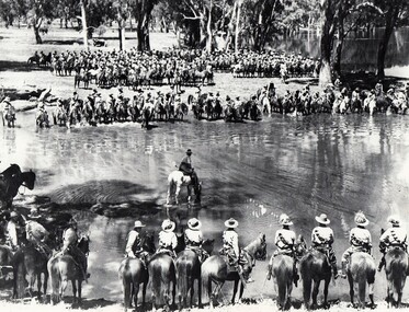
A rare photograph of massed Light Horse in Victoria shortly before mechanisation consigned the horse to history.Black and white photograph of large group of horsemen in ranks waiting in the process of watering horses at a lagoon. One copy of the image claims it to be 8th Light Horse Regiment watering horses at a Murray River lagoon, South Corowa NSW, September 1939; Wahgunyah Troop, C Squadron - this side of lagoon, Lieutenant J. Nott on grey horse in water. A second copy (Cat No 0690) asserts it is 4 regiments of light horse being 8th, 13th, 20th and 4th watering horses near Torquay Victoria, March 1940.On a label on reverse of 0690: "Picture taken about March 1940 when the 13th Light Horse from Gippsland, the 8th Light Horse from Upper Murray, the 4th Light Horse from the Western Districts and the 20th Light Horse from the Goulburn Valley were in camp near Torquay. Mr Cappur Webb of Glendoxey, Seymour, a member of the 20th said the picture must have been taken during and exercise about five miles north of Torquay. “We used to water our horses in that lake”, he said." -
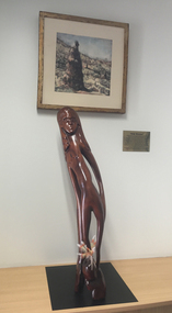 Federation University Art Collection
Sculpture - Artwork - Sculpture, Badger Bates, "Gitji Woman' by Badger Bates
William Brian (Badger) BATES (1947- ) Born Wilcannia Barkantji Badger Bates is a Barkantji Elder, political activist and contemporary artist. Known primarily for printmaking, wood and stone carving, his work is intrinsically linked to his lifelong fight for the safety and health of the Barka (the Darling River).'Gitji Woman' is carved from a very old piece of log found at Wittabrinna Creek near Tibooburra, Western New South Wales. The tree was dead for 60-80 years, and was hollow inside. "I could see a figure in the wood so I folowed the shapes already three. The woman has a drawn out figure with long fingers and is coming out of the log, she is an ancestral spirit. I put the pink cockatoo and emu feathers in the leg in the way people used to decorate themselves for corroborees."badger bates, paakantyi, wilcannia, timber, aboriginal, barkantji -
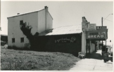 Kilmore Historical Society
Photograph, 13 Sydney Street, 1970's
Was the site of J. Quinn Bakery.20cm x 12.5cm black and white photograph of the Breakells Bakery and shop at 13 Sydney Street. This photo was taken from the south side of the building. Pictured is the shopfront, the outside of the single story shop building and a light coloured two story building in a the back of the shop building. On the side of the building advertising for "Kayes Hair Boutique". At the front of the shop there is a sign for "Hot Food". And on the awning of the shop there are multiple signs including: "Milkbar", "Streets ice cream" and "Fresh bread, pies & pasties". Printed on standard card stock.Written on the back: 486 14-86-35bakers, baker and bakeries, bakeries, 1970's -
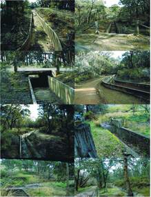 Bendigo Historical Society Inc.
Photograph - COLIBAN MAIN CHANNEL, July,2009
Photograph - colour. All photographs are of the Coliban Main Channel. Photo's 1,2,3,4 + 5 = were taken from South Mandurang Road, Spring Road end. Photo's 6,7,8,9,10,11,12 + 13 = were taken top of dirt road section of Springs Road. Photo's 14 + 15 = Taken between Sedgwick and North Harcourt, used to be called 'Prestonvale'. Photo No.14 is called Wirths Tunnel, 633 metres in length. Three more sheets of photo's of the Coliban Main Channel, between Sedgwick and Harcourt North. If more info.Ray Smith and Phil Wilkin - Bendigo Historical Society.place, water, coliban race, coliban main channel. -
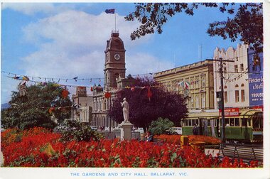 Ballarat Tramway Museum
Postcard, Rose Stereograph Co, "The Gardens and City Hall. Ballarat Vic.", mid 1960's
Has a strong association with the Rose Stereograph Co, demonstrates the gardens displays in Ballarat c1960's and yields information about the streetscape at the time.Colour postcard print of the central median gardens, Sturt St, with the Town Hall in the background and bogie tram No. 37 on the South Side. Has festoon lighting and other street decorations (Begonia Festival?) in the view. In the background are Myers, the Town Hall and Fletcher Jones store. No. 37 has the destination of Sebastopol and a "Switch to Electric Cooking" roof advertisement. Title "The Gardens and City Hall. Ballarat Vic." Postcard - Rose Series Colorview No. 509. On rear is the rose of Rose Stereograph Co and information. Duplicate of Reg Item - 1025On reverse side - black ink stamp "E.G.Butland"trams, tramways, town hall, gardens, sturt st, begonia festival, tram 37 -
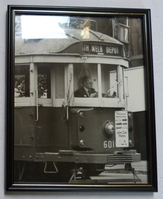 Melbourne Tram Museum
Photograph - Framed Photographs, John Phillips and Malvern Framing Gallery, 1990's
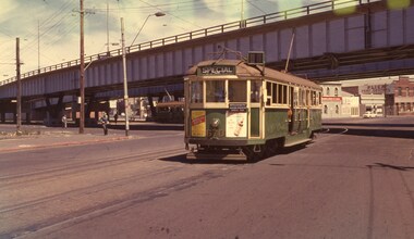
Framed photograph of Ron Scholten driving No. 601, during the 1990's? on a route 7, South Melbourne depot tram. Tram has an advertisements for John Ould Motors on the front dash panel. Photo by John Phillips. Framed in a wooden black frame with a think gold stripe, paper rear cover with a cotton hanging strip stapled in. Frame by Malvern Framing Gallery, 261 Glenferrie Road, Malvern, Vic 3144 with a 7 digit phone number - has the company sticker on the bottom of the frame on the rear.On top left of rear "Photo John Phillips" in pencil.trams, tramways, drivers, south melbourne depot, tram 601 -
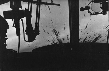 National Vietnam Veterans Museum (NVVM)
Photograph, Gibbons, Denis, The Playboys 2
Denis Gibbons (1937 – 2011) Trained with the Australian Army, before travelling to Vietnam in January 1966, Denis stayed with the 1st Australian Task Force in Nui Dat working as a photographer. For almost five years Gibbons toured with nine Australian infantry battalions, posting compelling war images from within many combat zones before being flown out in late November 1970 after sustaining injuries. The images held within the National Vietnam Veterans Museum make up the Gibbons Collection.A black and white photograph of a Huey Gunship from the 1st Platoon 334th Armed Helicopter with its windscreen sprayed with mud from the explosion after firing two rockets into a VietCong sampan, loaded with explosives and ammunition attempting to enter South Vietnam down the Mekong River from Cambodia. The sampan was blown to pieces with all on board being killed and the force of the explosion pushing the nose of the helicopter upwards. nearly turning the aircraft over. The pilot had to fight the controls to regain a normal flying attitude.photograph, 1st platoon, 334th armed helicopter coy, huey helicopter, the playboys, mekong river, cambodia, gibbons collection catalogue, denis gibbons, photographer, vietnam war, vietcong, sanpan -
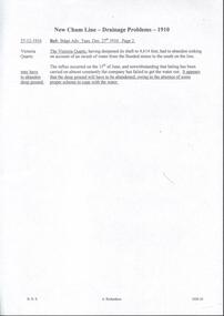 Bendigo Historical Society Inc.
Document - DRAINAGE PROBLEMS - NEW CHUM LINE DRAINAGE PROBLEMS 1910
Handwritten extract from the Bendigo Advertiser 27/12/1910 Page 2. ''The Victoria Quartz, having deepened its shaft to 4,614 feet, had to abandon sinking on account of an inrush of water from the flooded mines to the south on the line. The influx occurred on the 15th of June, and notwithstanding that baling has been carried on almost constantly the company has failed to get the water out. It appears that the deep ground will have to be abandoned, owing to the absence of some proper scheme to cope with the water.'' Albert Richardson Mining History Collection.document, gold, drainage problems, drainage problems, new chum line drainage problems 1910, bendigo advertiser 27/12/1910 page 2, victoria quartz, albert richardson -
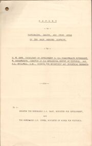 Bendigo Historical Society Inc.
Document - MCCOLL, RANKIN AND STANISTREET COLLECTION: REPORT ON CASTLEMAINE, MALDON & OTHER AREAS
Copy of a typewritten report on Castlemaine, Maldon, and other areas of the main Bendigo District by H.W. Gepp Consultant on Development to the Commonwealth Government. W. Baragwanath Director of the Geological Survey of Victoria and F.L. Stillwell D.Sc. Council for Scientific and Industrial Research. Mentions Castlemaine, Fryertown, Maldon, South German Mine, Mt. Tarrengower Tunnel, Raywood, Sebastian, Wedderburn, Inglewood, Whipstick, Lightning Hill, Black Forest Mine, Old Tom Mine. Trentham. Dated 17th September 1931. Consists of 19 Foolscap PagesH.W. Gepp, W. Baragwanath, F.L. Stillwell.gold, mining, report, gold mining, bendigo, castlemaine, maldon -
 Melbourne Tram Museum
Postcard, Nu-color-Vue, Nu-color-Vue of Swanston St, c1970's
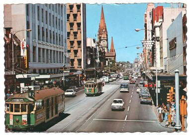
Postcard - full colour with serrated edge - Nu-color-Vue of Swanston St looking south with the Shrine of Remembrance in the view. Taken from just north of the corner of Little Bourke St. Has trams 373 (Carnegie, route 67) and 374 running a route 5. Has Christmas decorations in the street. Photo early 1970's. The rear is printed in green ink - card number ML 144, with place for stamp. Has title "Melbourne Victoria - Swanston Street looking to the Shrine of Remembrance".trams, tramways, postcards, swanston st, carnegie, tram 373, tram 374 -
 Melbourne Tram Museum
Letter, Australian Electric Traction Association (AETA), "Transporting Melbourne", 4/12/1996 12:00:00 AM
Letter - 8 A4 pages stapled in top left hand corner - AETA to "Transporting Melbourne", Ministry of Transport, dated 4-12-1996 forward comments or making a submission regarding the proposed framework. Endorse the concept, backlog in Melbourne public transport, railway electrification, tramway and light rail extensions; East Malvern Station, Box Hill, Station Pier, Westfield Shopping centre, Highpoint West, South bank Route and other suggestions made regarding re-routing of trams services.trams, tramways, aeta, submissions, new tramway, melbourne, public transport, box hill -
 Melbourne Tram Museum
Magazine, William F Scott, "Times Past", Sep. 1995
Australian Railway Enthusiast Magazine - September 1995, pager 9 (note dated June 1995 on this page only), featuring photographs of cable trams with the heading "Times Past" with captions by William F. Scott. - cable car set - bogie trailer - side on view - bogie car 472 in Sydney Road - cable car set at South Melbourne terminus, Victoria St MMTB with the destination of North Fitzroy, c1923 Also has an obituary on Eldon Hogan who died on 6/5/1995.trams, tramways, cable trams, south melbourne, north fitzroy, bogie cable trailers, sydney rd, tram 472 -
 Melbourne Tram Museum
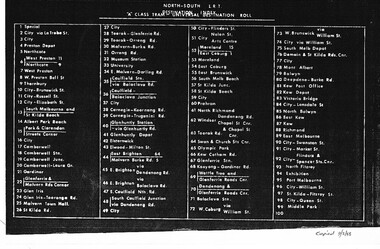
Document - List, Metropolitan Transit Authority (MTA), "Destination rolls", 9/02/1988 12:00:00 AM
Set of 5 foolscap photocopied sheets, lists the destination for each depot and the positioning on the roll. Copied by John Prideaux 9/2/1988. 1 - North South LRT - A class Tram Universal Destination Roll 2 - A class Tram Universal Destination Roll 3 - Z3 class tram - ditto 4 - "B" Roll - Z (1 + 2) class tram - ditto 5 - Universal (A) Destinations - possibly the "A" Roll for Z1 and Z2. See 3634 and 3635 for a c2010 Yarra Trams listing."copied 9/2/88" on the bottom right hand corner of most sheets in ink.trams, tramways, destination roll, the met, a class, light rail, z class, z3 class -
 Melbourne Tram Museum
Newspaper, The Age, “Fears Caulfield to Rowville tram plan no longer on track”, 30/05/2019 12:00:00 AM
Newspaper clippings titled: “Fears Caulfield to Rowville tram plan no longer on track” Newspaper clipping from the Age 30/5/2019 by Timna Jacks Councils in Melbourne's south-east suburbs concerned that plans for new tram line linking Caulfield train station and Monash University's Clayton campus have been shelved due to no money allocated in the budget. Premier Daniel Andrews had promised the government would plan and design an 18 kilometre tram route from Caulfield to Rowville.trams, tramways, planning, caulfield, tram routes, new tramway -
 Melbourne Tram Museum
Photograph - Set of 3 Colour Negatives, Phil A'Vard, 10/02/1962 12:00:00 AM
Set of 3 photographs taken on the AETA tour Sat. 10/2/1962 - Closure of the Local Tram Routes at Footscray. .1 - W4 670 passing under the King St bridge in Queensbridge St, South Melbourne. Has an AETA tour Auxiliary board is showing Special. .2 - ditto, followed by W3 655 crossing the Maribyrnong Road Bridge. .3 - ditto - turning on the reserved track alongside Wests Road. Taken on Perutz film - see 3997 for the AETA Tour circular. and see 5998 for other photographs.trams, tramways, footscray, aeta, maribyrnong river bridge, maribyrnong rd, wests rd, queensbridge st, w4 class, w3 class, tram 670 -
 Melbourne Tram Museum
Magazine, Dale Budd, "Melbourne on the brink of change", May. 1998
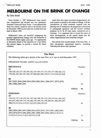
Photocopy, 12 sheets, of a magazine article titled "Melbourne on the brink of change", Trolley Wire, May 1998 by Dale Budd about the corporatisation of Melbourne's trams into Swanston and Yarra Trams. Gives details of the fleet, operational aspects, ticketing and driver-only operation. Includes notes on South Melbourne depot sale, historic fleet, non-passenger cars, Z class tram overhauls, pantograph operation, possible privatisation, Preston Workshops, low floor trams, W class. Also a brief update of March 1998.trams, tramways, swanston trams, yarra trams, south melbourne depot, driver only modifications, ticket machines, lists, depot allocation, z class, w class, heritage fleet, privatisation -
 Melbourne Tram Museum
Photograph - Black and White photograph, late 1920's
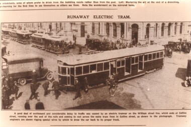
Sepia toned photograph titled "Runaway Electric Tram" of a W class tram that has over run or runaway from the William St terminus and is blocking cable trams in Collins St. Could be tram 230, 236, 290, 296. Has the original newspaper caption under neath - date not know - late 1920's. Shows tramway staff (captioned as Engineers) attaching a cable to pull the tram back over the intersection. Possibly one a set of cards made for the 70th anniversary of South Melbourne Depot.trams, tramways, w class, accidents, collins st, william st, cable trams -
 Melbourne Tram Museum
Pamphlet, The Met, "Met Plan", Sep. 1988
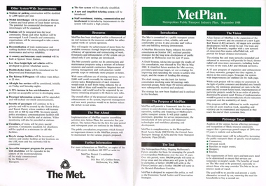
Folded A2 sheet to A4 size, full colour, printed both sides, titled "Met Plan" dated September 1988, detailing planning for Melbourne Public Transport, known as "MetPlan", prepared by The Met. Shows the various proposals for railway upgrades, tram extensions, details the purpose, the Task, Vision, Patronage, Resources, system improvements. Has details of projects proposed for the Western, Northern, Eastern and South Regions. On the inside has a large map of Melbourne showing the various projects. 2nd copy added 23-10-2016trams, tramways, melbourne, traffic control, transportation, met, planning, public transport, metplan, tramway proposals, railways -
 Melbourne Tram Museum
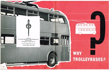
Book, The British Electrical & Allied Manufacturers' Association Inc" of London, "Why Trolleybuses?", May. 1956
Booklet - 16 pages, centre stapled, black and white photographs with red colour printed headings, titled "Why Trolleybuses?", published "The British Electrical & Allied Manufacturers' Association Inc" of London. Notes at BEAMA Publication No. 143, published as the 2nd edition, May 1956. Looks at the benefits of trolley buses over motor buses, their features, silence, life and cost. Has photographs of buses in Great Britain, Denmark, Portugal, Finland, South Africa, New Zealand, Australia (Adelaide) and Tasmania, along with sketches of animals."4K2" in ink on front cover and AETA stamp top and bottom of cover.trams, tramways, trolley buses, uk, electrical equipment -
 Melbourne Tram Museum
Photograph - Black & White Photograph/s, 1950's? to 1960's
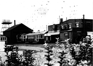
Black and white photograph of the area where the works or service or scrubber trams were parked at South Melbourne Depot. Has offices and shed in the background along with the depot water tank. Photo taken in the late 1950's early 1960's. In the view are No. 8 (later 8W), 10 (later 10W) and possibly No. 7 (later 7W) - cannot see the number but the photo matches that of the tram on page 76 of Destination City - 5th Edition) Printed on Fujichrome paper. Not known who took the photograph or when it was printed.Stamped in black ink on back "TMSV Sales"trams, tramways, south melbourne depot, scrubber tram, track cleaner, tram 7, tram 8, tram 10, tram 7w, tram 8w, tram 10w -
 National Vietnam Veterans Museum (NVVM)
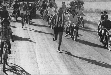
Photograph, Gibbons, Denis, Great Hung Vuong Day Roadrace
Denis Gibbons (1937 – 2011) Trained with the Australian Army, before travelling to Vietnam in January 1966, Denis stayed with the 1st Australian Task Force in Nui Dat working as a photographer. For almost five years Gibbons toured with nine Australian infantry battalions, posting compelling war images from within many combat zones before being flown out in late November 1970 after sustaining injuries. The images held within the National Vietnam Veterans Museum make up the Gibbons Collection. A black and white photograph of National Route 23, Phuoc Tuy Province, South Vietnam, Trooper Jack Thurgar 1st Special Air Service Sqnuadron, in 1st place leads Capt Craig Leggett the second runner up, also from 1st Special Air Service Squadron, to the finish line in the Great Hung Vuong Day Roadrace, 15 April1970. The third runner up, also from SAS, can just be seen behind the Army Land Rover. No Vietnamese runner is evident in the photophotograph, national route 23, phuoc tuy province, trooper jack thurgar, 1st sas sqn, capt craig leggett, gibbons collection catalogue, great hung vuong day road race, 1st special air service sqnuadron, land rover, denis gibbons