Showing 6762 items matching " rivers"
-
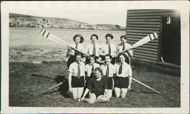 City of Warrnambool Rowing Club
Photograph
The photograph is believed to be taken in 1936. The rowers are young women- so this may be a school crew.Black and white photograph of 9 rowers and 2 oars on the banks of the Hopkins River, Warrnambool.No names given. -
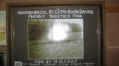 City of Warrnambool Rowing Club
Black and white photograph, Warrnambool Regatta Boxing Day 1908
Won by M.U.I.O.O.F. Crew: W. Marfett stroke, R.J. Russell 3, A.J. Fisher 2, H.G. Marfell bow, V. Williamson cox. “As its name suggests, Manchester Unity Independent Order of Oddfellows (MUIOOF) had its origins in Manchester, England. It was established in Melbourne in 1840 when Augustus Greeves, a member of the MUIOOF in England, migrated to Australia. On his arrival in Melbourne, Greeves teamed up with journalist Thomas Strode, to form the first lodge—The Australia Felix Lodge. The lodge received its Constitution on 7 December 1840 and this is recognised as the birth date of Manchester Unity in Victoria.” Warrnambool rowing club was founded in 1973, with regattas starting in 1885 and a VRA regatta in 1890. Timber framed black and white photograph of a mens rowing crew on the hopkins river, warrnambool.Warrnambool Regatta Boxing Day 1908 Friendly Society's Four Won by: M.U.I.O.O.F.rowing, city of warrnambool rowing club, warrnambool rowing club, hopkins river warrnambool, warrnambool regatta, 1908, 1908 -
 Brimbank City Council Art Collection
Photograph, Re-enactment of the Gallipoli Landings, 1919 (original)
Photographic re-enactment of the Gallipoli Landings , staged at Saltwater River Anzac Day 1919inscription along bottom of picture -
 Sunbury Family History and Heritage Society Inc.
Photograph, SUNBURY BATHS
The scene featured on the post card is a view of The Nook on the Jacksons Creek. For many years before the Aquatic Centre was build in the town, The Nook was the swimming place for local residents. The surrounding area had seats and change rooms. The Sunbury Swimming club was established at this site before the Aquatic Centre was built.A sepia photograph in post card format of river bend and small sandy beach on the bank.the nook, swimming -
 The Dunmoochin Foundation
Oil Painting, Melbourne 1962, 1962
Thick impasto painting depicting a bird's eye view of the city of Melbourne and the Yarra river.Signed and dated 'Eric Stewart 1962'. eric stewart, painting, landscape, melbourne, yarra river -
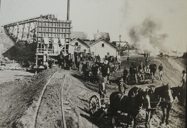 Wodonga & District Historical Society Inc
Photograph - Constructing the Hume Weir, c1928
This image is from Wodonga Historical Society's large collection of photographs documenting the construction of the Hume Dam during its initial construction and ongoing development. Hume Dam took 17 years to construct from the turning of the first sod on 28 November 1919 by Sir Ronald Munro-Ferguson, Governor-General of Australia. The first filling was in December 1934 and it was officially opened on 21 November 1936. Between 1950 and 1961 further modifications were made which enlarged its storage capacity. Progressive improvements have been made since that time to ensure the dam meets modern safety standards.This photo reflects a major stage in the construction of the Hume Dam.A large black and white image of construction of the Hume Weir on the Murray River mounted on board.hume dam construction, hume weir australia -
 Lakes Entrance Historical Society
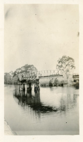
Photograph - Bridges, Bulmer, H D, 1887
Black and white photograph of the first road bridge over the Mitchell River at Bairnsdale, Victoria.township, waterways, bridges -
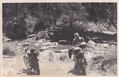 Falls Creek Historical Society
Photograph - George Shirling at the West Kiewa River
George Shirling arrived in Falls Creek in 1962. He engaged Phil Nowell to build the original Koki Alpine Lodge which opened in 1965 with 14 beds. George operated the lodge with Michael “Baldy” Blackwell as manager. He also graduated in sport psychology in 1981 and was invited to become team psychologist for the Australian Winter Olympic team which went to Albertville, France, in 1992. He later owned the Red Onion Chalet. George credited the success of Koki to “Baldy” Blackwell. “Baldy” and Phil Nowell started the Trackers Mountain Lodge in partnership during the 1980s. In 1971 George sold Koki Lodge to Sigi Doerr. In 2024 the renamed Koki Alpine resort remains a highly popular destination in Falls Creek. George Shirling passed away on 27th February 2023. He had remained actively involved in Falls Creek and was generous with his time and knowledge, always an amazing supporter of The Falls Creek Museum and Falls Creek Village.This photo is significant because it captures an image of two pioneers of pioneers and active members of Falls Creek Village.A black and white image of George Shirling with two motorbikes on the bank of the West Kiewa River.george shirling, koki lodge -
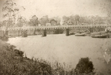
 Lakes Entrance Historical Society
Photograph - Bridges, Jemmeson, Edie, 1925
Also photograph of the bridge closed 7 x 11.5Black and white photograph of the swing bridge open over the Latrobe River at Longford, Victoria.bridges, waterways -
 National Wool Museum
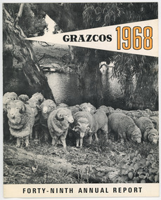
Document - Grazcos Annual Report, Grazcos Co-operative Limited, 1968
The co-operative was registered in 1919 as the Graziers Co-op Shearing Company Limited. It changed its name in September 1948 to Grazcos Co-operative Ltd. In 1981 the co-operative merged with Farmers & Graziers Co-op Ltd to form Farmers Grazcos Co-op Ltd. This item is part of a collection of Annual Reports from Grazcos dated from 1949 - 1980.Booklet featuring black and white image of sheep with river in background, and black and yellow text. front: GRAZCOS / 1968 / FORTY-NINTH ANNUAL REPORTagricultural co-operative, agricultural wholesaling, annual reports, rural life, rural industry, business, corporate body -
 Stawell Historical Society Inc
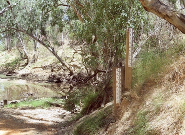
Photograph, Water height markers 2017 --- Coloured
Colour photo. Water height markers 2017Colour photo of river height markers beside a small body of water in bush setting.Water height markers - 2017water river -
 Sunbury Family History and Heritage Society Inc.
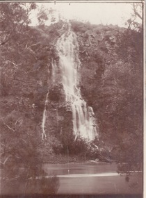
Photograph, c1920s
The waterfall is cascading down the Johnson Cliff which is on the Jacksons Creek downstream from Sunbury town.A sepia photograph with a narrow cream border mounted on cardboard of a waterfall cascading into the river below. johnsons cliff, jacksons creek, waterfalls -
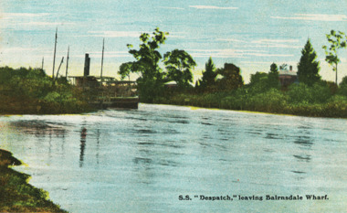 Lakes Entrance Historical Society
Postcard - S.S. Dispatch, VSM Series, 1900 c
Coloured postcard of SS Despatch leaving the Bairnsdale wharf on Mitchell River Bairnsdale VictoriaSS Despatch leaving Bairnsdale Wharfships and shipping, waterways, wharfs -
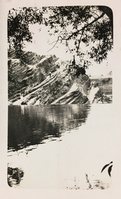
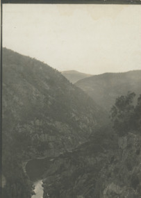 Lakes Entrance Historical Society
Photograph - Snowy River Gorge at Turlock Ard, Rev John Flynn, 1906
Photographic proof on light cardBlack and white photograph of views of Snowy River Gorge at Tulock Ard Gelantipy VictoriaJohyn Flynn Postcards from Buchan P39waterways -
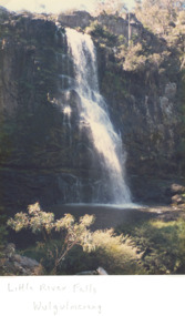 Lakes Entrance Historical Society
Photograph - Little River Falls , Wulgulmerang near Buchan Victoria, Bess Larkins, 1980 c
Colour photograph of the Little River Falls in full spate at Wulgulmerang near Buchan Victoriaenvironment, parks, topography -
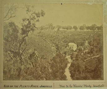 City of Whittlesea
Photograph (item) - Photographs - Landscapes, View on the Plenty River, Janefield
View on the Plenty River, Janefield / Vue de la Riviere Plenty - Janefield -
 National Wool Museum
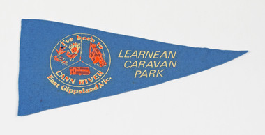
Pennant
LEARNEAN CARAVAN PARK I've been to CANN RIVER East Gippsland, Vic.cann river, east gippsland, victoria -
 University of Melbourne, Burnley Campus Archives
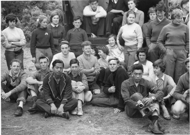
Photograph - Black and white print, Tidal River Excursion, 1955
Black and white photograph. Group of students standing and seated on the ground beside a truck. Also see B10.0144 (127-134).On reverse, "School of Horticulture Group Tidal River Cup Day Nov 1955."students, truck, school of horticulture, tidal river, 1955, excursion -
![Photograph - Construction of the F19 [Eastern Freeway], Ron Setford, October 1973](/media/collectors/550653872162f11fb04854aa/items/6808c3e9025de50d1e73220c/item-media/6808c404025de50d1e7324ef/item-fit-380x285.jpg) Kew Historical Society Inc
Kew Historical Society IncPhotograph - Construction of the F19 [Eastern Freeway], Ron Setford, October 1973
Ron Setford and his wife Grace Setford lived in Tanner Avenue, East Kew, from c.1946 to c.1995. A keen photographer, he recorded the changing face of Kew over a 20 year period. Apart from 30 photographs of built structures and places in Kew dating from 1960 and 1961, 145 of his 35mm colour slides chronicle the development of the F19 (later renamed Eastern) Freeway through the Yarra Valley in Kew over a five year period from c.1972 to c.1977. This important collection was donated to the Society by his granddaughter in 2025.This collection of 175 35mm slides is of local and statewide significance, owing to its subject matter, particularly the major development of road transport infrastructure during the 1970s with the construction of the Eastern Freeway. The photographer also took care to annotate and date most of his slides which enable the researcher to pinpoint temporal and spatial locations."Eastern Freeway / Chandler H/way to Fairfield / River Bridge Oct 73"ron setford, eastern freeway, f19 freeway -
 Bendigo Historical Society Inc.
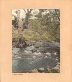
Photograph - STREAM AT MALMSBURY
Photograph, hand tinted. Stream at Malmsbury (Coliban River). History: with note 'Photographs from Mrs Ella Bourke, 131 Barnard St, Bendigo, ph 438269'. Photographs Francis (Frank) Thomas Kennedy'. James Lerk 'Coliban River'??Francil (Frank) Thomas Kennedyplace, landscape view, see also 2001.152.01, 2001.153.01, 2001.154.01, 2001.157.01, 2001.158.01, 2001.159.01, 2001.160.01, 2001.162.01 -
 University of Melbourne, Burnley Campus Archives
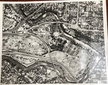
Photograph - Black and white print, Aerial View of Burnley Campus C.1970, c. 1970
Colour photograph of black and white photograph. Aerial View of Burnley Campus. Enlargement. Shows position of Campus in bend of Yarra River after alterations to the position of the river due to building of Freeway, new ovals and Richmond Public Golf Course.burnley campus, aerial view, yarra river, richmond public golf course -
 City of Kingston
Photograph - Colour, 1993
Carrum is a suburb in the City of Kingston bordered by the Patterson River in the north and Kananook Creek in the south. To the east the suburb is adjacent to Patterson Lakes. The Carrum Station was opened in 1882, when the railway line from Mordialloc was extended to Frankston. In the early 20th century, it was a destination for holidaymakers occupying tents and cabins. The area now consists of older housing and over time there have been many new housing developments.Carrum is located in the area that was originally part of the Carrum Carrum Swamp. The district had originally been the home of the Bunerong people who fished, gathered food and found refuge in the sand dunes. The Swamp was drained in 1879 when the Patterson Cut was formed and became known as Patterson River. Apart from local farmers, fishermen and hotel-keepers, there were few permanent residents until the early 20th century when it had become popular as a beach resort. In the 1920s and 1930s the area became occupied by more permanent residents.Laminated aerial colour photograph of Carrum and Patterson Lakes in the City of Kingston. The photograph also includes Kananook Creek and the northern section of Seaford. Prominent features include Roy Dore Reserve, Carrum Primary School, Patterson River Secondary College, Keast Park Seaford, the Seaford Swamp Drain and a section of Downs Estate situated on the traditional lands of the Bunurong people.Black type on white adhesive sticker: No. 7140 Black type of white adhesive sticker: 31-1-93 Black handwritten ink (marker): * [an asterisk] Yellow circular adhesive stickerpatterson lakes, seaford, carrum carrum swamp -
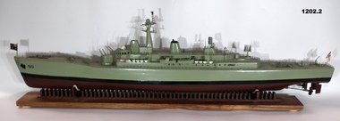 Bendigo Military Museum
Craft - MODEL & BASE, HMAS SWAN
Model of HMAS Swan built by Shipwright Charles Axiak. Original ship construction in Melbourne and entered service 1970. Was a River Class Destroyer. Model maker worked in British Dockyards during WW2 and emigrated to Australia in 1955. He worked in Williamstown dockyards involved with construction of the Swan,1. Model of River Class Destroyer. green in colour from water line. Black line and brown at bottom. Small Australian flag at front and naval flag at back. 2. Wooden stand, tailor made to hold the model of the 'Swan'. Brown in colour with long flat board and separate pieces of wood embedded in the base to make the cradle. High points of cradle covered by some white felt to protect boat. Bottom of stand has felt studs."50" painted at front of boat.ships model, hmas swan -
 Kew Historical Society Inc
Photograph - Dight's Falls, 1924
Henry Beater Christian (1886-1962) , was a descendant of one of the earliest settler families in Kew. Employed at the Kew Asylum as a 'public servant', he was a skilled amateur photographer, photographing numerous scenes in Kew and on his travels around Victoria. The majority of his photographs date from 1916 to 1929. His finest photographs are housed in two photograph albums. Digital copy of a photograph from page 6 of the 47-page photograph album containing 261 gelatinous silver images, loaned by Diane Washfold with permission given to digitise and hold a copy in our collection. This is a photograph id of the. Yarra River at Dight's Falls. The point of view is from the freshwater section of the river looking across to the cliffs on the Kew side of the river. Standing on the cliffs is a tiny figure of a man. "Yarra Rvr / Kew"henry beater christian (1886-1962), landscape photography, kew (vic.) — yarra river, christian-washfold collection, photograph albums, dight's falls -
 Melbourne Tram Museum
Photograph - Digital Image, Kevin O'Reilly, Richmond looking east along the Yarra River, c1930's
Image from CD (Compact Diskette for use in computers) - see Reg Item 135. Image titled "Richmond 7" on CD, of looking east along the Yarra River where the Church St Bridge Richmond crosses the River, Alexandra Ave. Has an ex HTT Maximum Traction tram crossing the bridge. Shows now Herring Island after the Yarra River was cut through to form the island.trams, tramways, richmond, chapel st, church st, yarra river -
Kew Historical Society Inc
Collection, Floods in North Kew (Series), 1929–1934
Flooding of the Yarra Valley, including that section of the Yarra bordering Kew and Kew East in the north and west of the municipality, was a regular occurrence. Extreme flood events of the Yarra River are recorded to have occurred in 1891, 1901, 1916, 1923 and 1934. The Municipality of Kew's response to these floods was to enact planning decisions restricting residential development in flood prone areas following the floods of 1916, 1921 and 1934. While floods continued after the development of the Upper Yarra Reservoir (construction 1948-57), the regularity and extent of these inundations diminished. Natural disasters had an impact on the development and settlement of Melbourne and its suburbs. Flooding in the Melbourne region was a regular event in the nineteenth and for most of the twentieth centuries. Changes in the impact of natural disasters could occur due to a number of factors. This collection of small snapshots, mostly taken from Kellett Grove in North Kew, provide provenanced evidence of flooding in the area before the development of the unnatural flood barrier that is the Eastern Freeway.Collection of 16 monochrome photographs, annotated on verso by different hands, of the flooding of the River Yarra in North Kew in the third and fourth decades of the twentieth century [1920s & 1930s]. Individual photos include the dates of different floods. Many of the photos were taken from the rear of 8 Kellett Grove; a house still extant in 2023yarra river -- north kew, floods -- yarra valley, floods -- north kew, floods -- 1929, floods -- 1934, natural disasters -- kew -
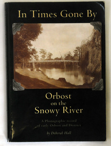 Orbost & District Historical Society
book, In Times Gone By, 2002
The book was written by Deborah Hall in order to preserve the memories of Orbost locals as well as to record its early history. Local history tends to be less documented than other types, with fewer books and artifacts than that of a country or continent. Many local histories are recorded as oral tales or stories and so are more vulnerable than more well known issues. Because it records in a scholarly way the meories of local residents, Deborah Hall's book is a commonly used reference for the early history of Orbost and districtA 158 pp book titled In Times Gone By Orbost on the Snowy River. It is a photographic record of early Orbost and District. It has a dark green coverwith a photograph of the first pile bridge over the Snowy river at Orbost. The book was authored by Deborah Hall.orbost-history reminiscences hall-deborah -
 Bendigo Military Museum
Photograph - PHOTOGRAPH - FRAMED WW1, Wayne Eels, C.2008/2009
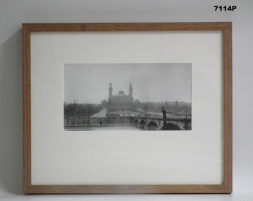
The Grinton Collection. “Palais due Trocadero"- built on the hill of Chjaillot, across the Seine from the Eiffel tower, Paris , France. Demolished in 1937. RRefer Cat No 1280 for Jack Grintons service details.Photograph framed. Photograph - black and white photograph on paper, depicting a large building (palace/exhibition space) with formal garden area, river, river wall and bridge in foreground. Frame - timber, light varnish finish, Perspex front, cardboard backing."Group 3: Trip of Lifetime". "A. Palais due Trocadero". framed accessories, camera on the somme, 38th bn, ww1, grinton, buildings -
Glenelg Shire Council Cultural Collection
Photograph - Photograph reprint of a scan of a photograph - Casterton, Victoria 1874, n.d
Vern McCallum CollectionReprint of a scan of a black and white photograph. A view of Casterton in 1874, taken from an elevated position. Glenelg River visible running left to right acros print, 2 bridges over river. Print is mounted on archival, white, mountboard frame. -
 Lakes Entrance Historical Society
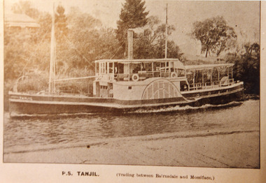
Photograph - P.S. Tanjil, 1910 c
Sepia photograph of postcard showing P S Tanjil in the Mitchell River Bairnsdale Wharf, house on rise opposite the wharf. Wharf decking across bottom of photo. Vegetation and pine trees on river bank. Tanjil travelling upstream. Bairnsdale VictoriaP.S Tanjil (Trading between Bairnsdale and Mossiface)ships and shipping, waterways, trading