Showing 3818 items matching "1890s-1930s"
-
 Kew Historical Society Inc
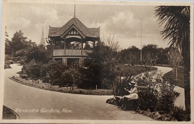
Postcard, Oastler (Leading Stationer), Alexandra Gardens, Kew, c.1910
The Kew Historical Society's postcard collection includes views of Kew, Melbourne and Greater Melbourne as well as those including overseas scenes sent or received from Europe or the Middle East. They date from the 1890s to the 2000s. These postcards may or may not include the name of the publisher or printer. A number of the cards were published as parts of popular series. A way of dating early postcards is to identify whether the reverse was divided by a central line which became the norm after 1902 in the United Kingdom. However, other postcards produced after this date do not always conform to this print layout.Historic postcard of local significance showing the layout of the Alexandra Gardens in Kew. The gardens were opened in 1908 and designed/planted by the Pockett Brothers, so the planting reflects their horticultural style as well as that of the period. The postcard also depicts the Kew Jubilee Rotunda (later demolished and replaced by a second structure in 1988).Monochrome postcard showing the original 'Jubilee Rotunda' in the Alexandra Gardens in Cotham Road.Alexandra Gardens, Kew Oastler Leading Stationer, Kew / Printed in Saxonypostcards -- kew (vic.), alexandra gardens -- kew (vic), rotunda -- alexandra gardens -- kew (vic.), oastler -- stationers -- kew (vic.) -
 Kew Historical Society Inc
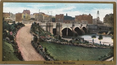
Postcard, Princess Bridge, Melbourne, c.1907
The Kew Historical Society's postcard collection includes views of Kew, Melbourne and Greater Melbourne as well as those including overseas scenes sent or received from Europe or the Middle East. They date from the 1890s to the 2000s. These postcards may or may not include the name of the publisher or printer. A number of the cards were published as parts of popular series. A way of dating early postcards is to identify whether the reverse was divided by a central line which became the norm after 1902 in the United Kingdom. However, other postcards produced after this date do not always conform to this print layout.Rare variant version of this view of Princes Bridge, from the south-east bank of the Yarra River, looking towards the city of Melbourne, showing landmarks of the period.Polychrome postcard of Princess Bridge in Melbourne.Princess Bridge, Melbourne Miss McGilivray, "Oak Bank", Peterborough, _____. princess bridge -- melbourne (vic.), river yarra, postcards -- melbourne (vic.) -
 Kew Historical Society Inc
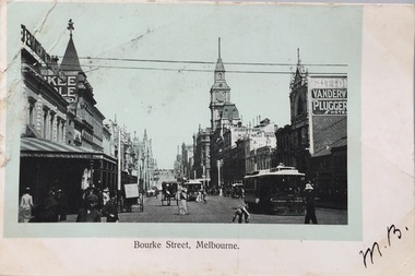
Postcard, Bourke Street, Melbourne, 1920-1920
The Kew Historical Society's postcard collection includes views of Kew, Melbourne and Greater Melbourne as well as those including overseas scenes sent or received from Europe or the Middle East. They date from the 1890s to the 2000s. These postcards may or may not include the name of the publisher or printer. A number of the cards were published as parts of popular series. A way of dating early postcards is to identify whether the reverse was divided by a central line which became the norm after 1902 in the United Kingdom. However, other postcards produced after this date do not always conform to this print layout.Monochrome postcard of Bourke Street, Melbourne, looking west from Swanston Street. The costumes of the women in the photograph would indicate the use of an earlier photograph dating from the 1885-1895.Mrs L. Clark, Ecclesbourne, Harp Road, East Kew / Wishing you many happy returns of the Day, M. Boylebourke street - melbourne, postcards -- melbourne (vic), photographic postcards -
 Kew Historical Society Inc
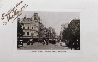
Postcard, Collins Street (looking West), Melbourne, 1907-1914
The Kew Historical Society's postcard collection includes views of Kew, Melbourne and Greater Melbourne as well as those including overseas scenes sent or received from Europe or the Middle East. They date from the 1890s to the 2000s. These postcards may or may not include the name of the publisher or printer. A number of the cards were published as parts of popular series. A way of dating early postcards is to identify whether the reverse was divided by a central line which became the norm after 1902 in the United Kingdom. However, other postcards produced after this date do not always conform to this print layout.Early postcard of MelbourneSepia tinted postcard of Collins Street, Melbourne, Th postcard design includes a line separating the address from the message on the reverse, which dates it after 1902. The stamp on the card is a red Victorian stamp with the head of Queen Victoria in use 1901-1911.Front title - Collins Street (looking West), Melbourne Reverse. - Mrs Garahy, Creek Parade, Clunes, Vic / Dear Mollie / All join with me in wishing you and our dear mother a very prosperous and happy New Year. I am enjoying my holidays very much. I heard Melba last week and went to the pantomime Humpty Dumpty. - it was all lovely. I’ll tell you all about them when I return to Clunes. We were all home for Xmas Day. The first time for 17 years. Fondest love. N.C. / I cut my right hand very badly last Monday and have not been able to write till today. N.C.postcards -- melbourne (vic.), collins street --- melbourne (vic) -
 Kew Historical Society Inc
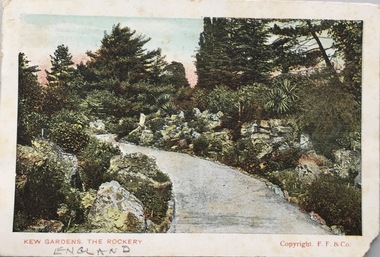
Postcard, Kew Gardens, The Rockery, 1902-1912
The Kew Historical Society's postcard collection includes views of Kew, Melbourne and Greater Melbourne as well as those including overseas scenes sent or received from Europe or the Middle East. They date from the 1890s to the 2000s. These postcards may or may not include the name of the publisher or printer. A number of the cards were published as parts of popular series. A way of dating early postcards is to identify whether the reverse was divided by a central line which became the norm after 1902 in the United Kingdom. However, other postcards produced after this date do not always conform to this print layout.Colour postcard of the Rockery, in Kew Gardens, London. Front - Kew Gardens, The Rockery / Copyright F.F. & Co. Reverse - POST CARD / FOR INLAND POSTAGE THIS SPACE, AS WELL AS THE BACK, MAY NOW BE USED FOR COMMUNICATION. FOR FOREIGN POSTAGE THE BACK ONLY (Post Office Regulation) /THE ADDRESS ONLY TO BE WRITTEN HERE. Dear Henry. Many thanks for Birthday greetings received today the first one to remember me. Hope you are well as this leaves all. Thi sis the only postcard in Sea Lake so excuse. No more just now with kind regards from Estherpostcards -- uk, postcards -- kew gardens, kew gardens -- the rockery -
 Kew Historical Society Inc
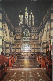
Postcard, Paul Ahearne, St Paul's Cathedral, Sanctuary, 1950-1965
The Kew Historical Society's postcard collection includes views of Kew, Melbourne and Greater Melbourne as well as those including overseas scenes sent or received from Europe or the Middle East. They date from the 1890s to the 2000s. These postcards may or may not include the name of the publisher or printer. A number of the cards were published as parts of popular series. A way of dating early postcards is to identify whether the reverse was divided by a central line which became the norm after 1902 in the United Kingdom. However, other postcards produced after this date do not always conform to this print layout.Colour postcard of the interior of St Paul's Cathedral, Melbourne by Max Ahearne, Renwick Pride, Gravure Print.St Paul's Cathedral, Melbourne, Australia - Sanctuary / Foundation stone, 1880; Consecrated 1891; Spires computed 1931. Exterior length, 276 feet. Moorhouse spire, 317 feet in height. Architect, William Butterfield, 1814-1900. / Colour photo by Max Ahearne, Renwick Pride, Gravure Print.st paul's cathedral -- melbourne (vic.), postcards -- churches -- melbourne (vic.) -
 Kew Historical Society Inc
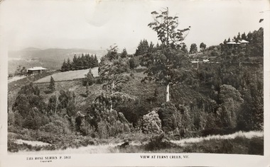
Postcard, Rose Stereograph Company, View at Ferny Creek, Vic, 1925-1939
The Kew Historical Society's postcard collection includes views of Kew, Melbourne and Greater Melbourne as well as those including overseas scenes sent or received from Europe or the Middle East. They date from the 1890s to the 2000s. These postcards may or may not include the name of the publisher or printer. A number of the cards were published as parts of popular series. A way of dating early postcards is to identify whether the reverse was divided by a central line which became the norm after 1902 in the United Kingdom. However, other postcards produced after this date do not always conform to this print layout.A Rose Series postcard of Ferny Creek in the Dandenongs to the north of Melbourne. The monochrome postcard is numbered P. 3811.Front: THE ROSE SERIES P. 3811 COPYRIGHT / VIEW AT FERNY CREEK, VIC. Reverse: POST CARD / THE ROSE SERIES DELUXE / A REAL PHOTOGRAPH PRODUCED IN AUSTRALIA / PUBLISHED BY THE ROSE STENOGRAPH CO., ARMADALE, VICTORIA / [Inscription] Many Happy Returns of the day, Mum.ferny creek - victoria, postcards -
 Kew Historical Society Inc
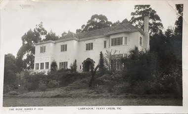
Postcard, Rose Stereograph Company, "Labrador," Ferny Creek, Vic, 1920-1939
The Kew Historical Society's postcard collection includes views of Kew, Melbourne and Greater Melbourne as well as those including overseas scenes sent or received from Europe or the Middle East. They date from the 1890s to the 2000s. These postcards may or may not include the name of the publisher or printer. A number of the cards were published as parts of popular series. A way of dating early postcards is to identify whether the reverse was divided by a central line which became the norm after 1902 in the United Kingdom. However, other postcards produced after this date do not always conform to this print layout.A Rose Series postcard of "Labrador" in Ferny Creek in the Dandenongs to the north of Melbourne. The postcard is numbered P. 1511.Front: THE ROSE SERIES P. 1511 COPYRIGHT / "LABRADOR' FERNY CREEK, VIC / THE ROSE SERIES DELUXE / A REAL PHOTOGRAPH PRODUCED IN AUSTRALIAferny creek - victoria, labrador - ferny creek, postcards, guest houses -- ferny creek (vic.), labrador -- ferny creek (vic.) -
 Kew Historical Society Inc
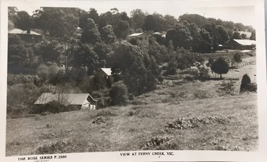
Postcard, Rose Stereograph Company, View at Ferny Creek, Vic, 1920-1938
The Kew Historical Society's postcard collection includes views of Kew, Melbourne and Greater Melbourne as well as those including overseas scenes sent or received from Europe or the Middle East. They date from the 1890s to the 2000s. These postcards may or may not include the name of the publisher or printer. A number of the cards were published as parts of popular series. A way of dating early postcards is to identify whether the reverse was divided by a central line which became the norm after 1902 in the United Kingdom. However, other postcards produced after this date do not always conform to this print layout.A Rose Series postcard of Ferny Creek in the Dandenongs to the north of Melbourne. The postcard is numbered P. 2880.Front: THE ROSE SERIES P. 2880 COPYRIGHT / VIEW AT FERNY CREEK, VIC / Reverse: POST CARD / THE "ROSE' SERIES DELUXE / A REAL PHOTOGRAPH PRODUCED IN AUSTRALIA / PUBLISHED BY THE ROSE STEREOGRAPH CO., ARMADALE, VICTORIArose stereograph company postcards, ferny creek - victoria, postcards -- ferny creek -
 Kew Historical Society Inc
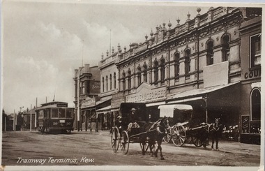
Postcard, Oastler (Leading Stationer), Tramway Terminus, Kew, c.1913
The Kew Historical Society's postcard collection includes views of Kew, Melbourne and Greater Melbourne as well as those including overseas scenes sent or received from Europe or the Middle East. They date from the 1890s to the 2000s. These postcards may or may not include the name of the publisher or printer. A number of the cards were published as parts of popular series. A way of dating early postcards is to identify whether the reverse was divided by a central line which became the norm after 1902 in the United Kingdom. However, other postcards produced after this date do not always conform to this print layout.A monochrome postcard of the tram terminus beside 'The Block' in Cotham Road, KewOastler, leading stationer, Kew / Printed in Saxonypostcards -- kew (vic.), trams -- kew (vic.), cotham road -- high street --- kew (vic.), the block -- cotham road -- kew (vic.) -
 Kew Historical Society Inc
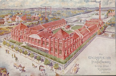
Postcard, The Wertheim Piano Factory, Bendigo Street, Richmond, Melbourne, c.1906
The Kew Historical Society's postcard collection includes views of Kew, Melbourne and Greater Melbourne as well as those including overseas scenes sent or received from Europe or the Middle East. They date from the 1890s to the 2000s. These postcards may or may not include the name of the publisher or printer. A number of the cards were published as parts of popular series. A way of dating early postcards is to identify whether the reverse was divided by a central line which became the norm after 1902 in the United Kingdom. However, other postcards produced after this date do not always conform to this print layout.Polychrome postcard of the Wertheim Piano factory in Richmond.KH-152. H.V. Barlow, Head Office, 173 William St., Melbournewertheim piano factory, bendigo street - richmond, postcards -- richmond (vic.) -
 Kew Historical Society Inc
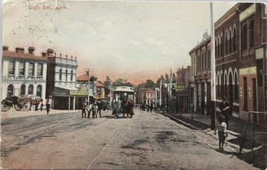
Postcard, High Str., Kew, c.1906
The Kew Historical Society's postcard collection includes views of Kew, Melbourne and Greater Melbourne as well as those including overseas scenes sent or received from Europe or the Middle East. They date from the 1890s to the 2000s. These postcards may or may not include the name of the publisher or printer. A number of the cards were published as parts of popular series. A way of dating early postcards is to identify whether the reverse was divided by a central line which became the norm after 1902 in the United Kingdom. However, other postcards produced after this date do not always conform to this print layout.Polychrome postcard of High Street, Kew looking west towards Kew Junction. The photograph was also printed in monochrome format by the publishers, with different names and additions.Reverse - (to) Miss __. J. Thompson, "Dry Lake", Kerang (from) Very sorry indeed to hear of your Mother's illness. Sincerely hope all quite well ere this. Still going about very tired waiting __ being away. Love to all M.B.L.high street -- kew (vic.), postcards -- kew (vic.), horse tram -- kew (vic.) -
 Kew Historical Society Inc
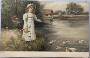
Postcard, Meissner & Buch, In Der Schonen Natur, 1902-1910
The Kew Historical Society's postcard collection includes views of Kew, Melbourne and Greater Melbourne as well as those including overseas scenes sent or received from Europe or the Middle East. They date from the 1890s to the 2000s. These postcards may or may not include the name of the publisher or printer. A number of the cards were published as parts of popular series. A way of dating early postcards is to identify whether the reverse was divided by a central line which became the norm after 1902 in the United Kingdom. However, other postcards produced after this date do not always conform to this print layout.Coloured postcard, produced in Germany, showing a girl feeding ducks beside a stream. The postcard was sent by Willie Feely to his cousin Alica (Alice Porter).Reverse: (To) Dear Alica. I will see you soon I will be home on Saturday week. I hope you are better. Give my love to your Mother and Father and Grandma I remain your loving Cousin, Wille Feely xxxxxxxxxx kissespostcards, german postcards, sentimental post cards -
 Kew Historical Society Inc
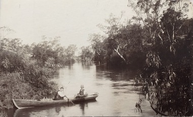
Postcard, Yarra Towards Fairfield, 1905-1914
The Kew Historical Society's postcard collection includes views of Kew, Melbourne and Greater Melbourne as well as those including overseas scenes sent or received from Europe or the Middle East. They date from the 1890s to the 2000s. These postcards may or may not include the name of the publisher or printer. A number of the cards were published as parts of popular series. A way of dating early postcards is to identify whether the reverse was divided by a central line which became the norm after 1902 in the United Kingdom. However, other postcards produced after this date do not always conform to this print layout.Monochrome postcard showing two men in a rowboat on the River Yarra at Kew in the area of Macaulay's Boat Shed.Handwritten later annotations: "Reg No KH-384. Yarra towards Fairfield. Macaulay's Boat House, Kew"postcards - kew (vic), river yarra - kew (vic), sport and recreation - kew (vic), recreation - kew (vic), boat sheds - kew (vic) -
 Kew Historical Society Inc
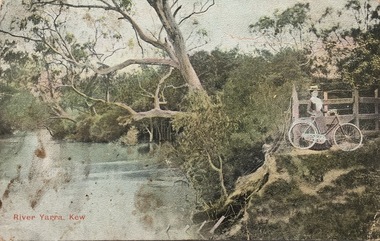
Postcard, River Yarra, Kew, 1905-1914
The Kew Historical Society's postcard collection includes views of Kew, Melbourne and Greater Melbourne as well as those including overseas scenes sent or received from Europe or the Middle East. They date from the 1890s to the 2000s. These postcards may or may not include the name of the publisher or printer. A number of the cards were published as parts of popular series. A way of dating early postcards is to identify whether the reverse was divided by a central line which became the norm after 1902 in the United Kingdom. However, other postcards produced after this date do not always conform to this print layout.One of a series of pictorial postcards showing a woman on a bicycle near to the River Yarra in Kew.Polychrome postcard of the River Yarra at Kew, showing a woman with a bike (right) looking away from the River.My dear friend I suppose you will think I am a "beauty", but I have no excuse to offer for not writing, only the longer I put it off the longer I want to. I hope the change did you a lot of good & that you feel quite well & strong. Everything here is something about the same. Our two new ministers are nice but I like Mr Dowsing better so far. The weather lately is glorious, just the thing for long walks. Jane Rowe & I go for a walk after church on Sunday nights. That is the most walking I do lately. No room for more. Love from your friend C.G.[sic]postcards -- kew (vic.), postcards -- yarra river -- kew (vic.), colour postcards -- kew (vic.) -
 Kew Historical Society Inc
Postcard, Little Residential, Your Little Piece of Kew, c.2013
The Kew Historical Society's postcard collection includes views of Kew, Melbourne and Greater Melbourne as well as those including overseas scenes sent or received from Europe or the Middle East. They date from the 1890s to the 2000s. These postcards may or may not include the name of the publisher or printer. A number of the cards were published as parts of popular series. A way of dating early postcards is to identify whether the reverse was divided by a central line which became the norm after 1902 in the United Kingdom. However, other postcards produced after this date do not always conform to this print layout.Commercial postcard produced by Little Residential showing the Kew War Memorial, the QPO Restaurant and the former Kew Court House.The reverse includes details about the company and its services (see image)postcards, qpo restaurant, kew post office, kew war memorial -
 Williamstown Botanic Gardens- Hobsons Bay City Council
Photos - Cannons, 1970
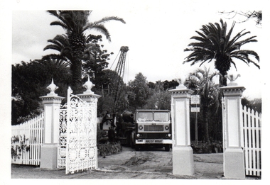
The Armstrong Cannons were originally placed at Fort Gellibrand, located at the southernmost tip of the Williamstown peninsula. The Fort was developed during the 1850s as part of a defensive system for the city and port of Melbourne. The importance of the Fort batteries declined from the 1890s, when they were effectively replaced by new facilities at Queenscliff and Point Nepean, but they were still used for gunnery practice. Local residents, through the Williamstown Town Council, complained to the Acting Minister for Defence that the concussion from the guns damaged windows, walls and foundations of buildings. The Armstrong Cannons were moved from Fort Gellibrand to the Gardens in 1906. A primary source of evidence of the cannons being in the Gardens. The cannons are remembered fondly as play equipment for the local children. Many tales have been told of climbing over them and pretending to be shot out of them A collection of seven black and white photographs documenting the removal of the cannons from the Gardens Photo 1 (a) Black and white landscape image. View is looking through the main gates looking at the front of the truck, which has the name Walter Wright across the front bumper, the crane and canon. The gates and fence are painted a light colour, probably white. Photo 2 (b) Black and white landscape image. Back of loader with cannon on it. Man standing on top of the cannon bending over either tying or untying ropes. Trunk of a palm tree is on the left side of the photo with a top of a palm tree in the background. Photo 3 (c) Black and portrait white image. A cannon being loaded by the crane on to trailer. Palm tree is in the background and fronds from a palm tree can be seen in the right top corner. Photo 4 (d) Black and white landscape image. Side on view of a cannon on the truck parked outside the grounds of the Gardens. The logo of the name of the trucking company is on the door of the truck above the words ‘WALTER H WRIGHT / TRANSPORT PTY LTD / S SCHULZ ST WEST MELB’. A second cannon can be seen in the background. A bus is in the background on the middle right side of the image. Photo 5 (e) Black and white landscape image. Truck with cannon on the back leaving the ground of the Gardens. Tree on the right side of the image and power pole is behind the truck. The logo of the name of the trucking company is on the door of the truck above the words ‘WALTER H WRIGHT / TRANSPORT PTY LTD / S SCHULZ ST WEST MELB’. ‘WALTER WRIGHT’ is on the front bumper Photo 6 (f) Black and white landscape image. Cannon tied down on the back of the truck as it is being driven across the street. Three houses in the background and two cars, one is a Volkswagen Photo 7 (g) Black and white landscape image. Cannon on the back of the truck which is parked over the street from the Gardens. Three houses are in the background. Two trees bare of leaves. The front of a car in in the foreground – it has a sun visor and the steering wheel is a light colour.armstrong cannons, williamstown botanic gardens, hobsons bay city council, 1970, walter h wright / transport pty ltd -
 Vision Australia
Audio - Sound recording, Vision Australia, Around Vision Australia: Episode 22
Covering issues and news about Vision Australia and the opportunities it provides for clients, volunteers and staff. Host: Stephen Jolley with guest interviews by Valerie Thomas. Stephen talks with Rachel Johnson about Tilly Aston establishing the first library in the 1890s, the production of 21st Century talking books and how to become a member of the library. Valerie Thomas interviews Dr Lynne Davies about the way Vision Australia reports assist the chairman implement the Client representative Council framework. Finally, Donor Relations Manager Sharon Standen provides an overview of her role in helping fund services.1 digital sound file in WAV formatradio shows, vision australia, valerie thomas, stephen jolley, rachel johnson, lynne davies, sharon standen -
 Buda Historic Home & Garden Castlemaine
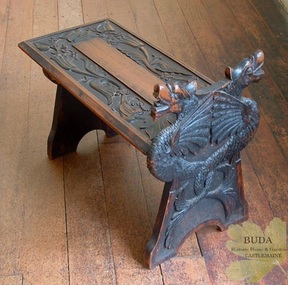
Domestic furniture, Timber hand-carved boot stool, c1900
The British Arts and Crafts Movement was a major influence on handcrafts made by the Leviny women at Buda. This Movement spread knowledge of craft techniques in the decorative arts and encouraged women to partake in fields that had traditionally been the domain of men, such as metalcraft and woodwork. The Leviny women studied art, design and craft techniques at the Castlemaine School of Mines from the 1890s to the early 1900s and this boot stool, hand-carved by Gertrude, is an example of the influence of the Arts and Crafts Movement on her decorative art. See: Zilles, Lauretta (2010), Buda and the Leviny Family, Castlemaine: Buda Historic Home & Garden Inc.This is a rare example of a unique hand-carved boot stool made in Australia by Gertrude Leviny in the British Arts and Crafts Movement style at the turn of the twentieth century.Timber boot stool, hand-carved by Gertrude Leviny. Made using the 'chip carving' technique, with dragon heads on upright at one end, and plant design in relief on the seat. Timber finish has a blackened effect.'K/40' (Old Registration Number)gertrude leviny, wood carving, arts and crafts movement, buda, castlemaine, dragon's heads, c1900, domestic furniture, castlemaine school of mines -
 Linton and District Historical Society Inc
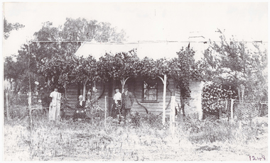
Photograph, Crosier Family Home at Happy Valley
This photograph is believed to have been taken in the 1890s at the Crosier property at Happy Valley (the Crosiers lived along the road leading to the Happy Valley School. Crosier descendants still live on this site). People in the photo are thought to be, L-R: Nell Crosier, Mary Crosier (née Hogan), Maggie Crombie (née Crosier), Jack Crombie. Mary Crosier was the second wife of Henry Crosier (1825-1901), a miner and farmer at Happy Valley. They had eight children. Their oldest daughter Maggie Crosier (1865-1932) married John Charles (Jack) Crombie in 1893. The Crombies farmed at Durham Lead.Black and white copy of original photograph showing a small weatherboard house with climbing plants along the verandah. Standing in front of the house are two women, with an older lady sitting between them, and a gentleman standing on the right, next to one of the women.crosier family home, miss crosier, mrs crosier, jack crombie, maggie crombie (nee crosier), happy valley -
 Orbost & District Historical Society
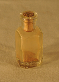
specimen bottle, circa 19th, early 20th century
On loan from John Mundy family. Searching for gold in the Orbost district began in the last half of the 19th century and continued until circa 1930s. The original Mundy family moved to a land "selection" at Betebolong in the early 1880's from Buchan. This item is reflective of the late 19th -early 20th century gold mining era in East Gippsland.A small square bottle with a push-in cork stopper. This bottle contains specks of gold or gold dust. mining-gold -
 Mission to Seafarers Victoria
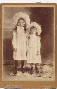
Photograph - Gelatin silver photograph, Wherrett & Co, c. 1910
This photograph is part of a donated sub-collection relating to the history of the Ladies Harbour Lights Guild. This photograph is presumed to be of two sisters named Lillie and Olive Duncan, who were members of the Guild in the 1930s & 1940s. Their father David Hood Duncan was a farmer. This is a photograph of social and historic significance, being part of a sub-collection of material that provides a snapshot of the type of individuals involved in the LHLG and the activities carried out by that organisation. The image is also significant as an insight into the childhood of these two young girls.Sepia photograph of two young girls in white long-sleeved dresses and wide ruffled white hats tied with a large bow under the chin. The photograph is mounted on a brown cardboard.Inscribed on base edge of mount "Wherrett & Co." "The Studio: SALE" ladies harbour lights guild, lillie duncan, olive duncan, girls, lhlg, sale -
 Warrnambool and District Historical Society Inc.
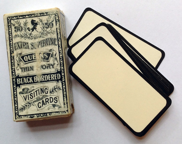
Domestic object - Card, visiting. Blank cards with black border, Early 20th century
These visiting cards have been commercially produced for those who have suffered a bereavement and wish to leave a visiting card when calling on friends, business acquaintances etc. They would have been used in the 19th century and up to about the 1930s. These cards have no known provenance but are of interest because they are a good example of bereavement customs a hundred years ago and earlier. These are two packs of visiting cards, white with black borders. They are made of lightweight card and enclosed in an open cardboard envelope and these are further contained in another cardboard envelope. Originally the envelopes contained 50 cards each but there are now 49 in one box and 41 in the other. The boxes are white with black and white printing and ornamental decorations. On front and back of box – ’50 Extra Superfine Queens Thin Ivory Black Bordered Visiting Cards’ bereavement customs, visiting cards -
 Eltham District Historical Society Inc
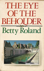
Book, Hale & Iremonger, The Eye of the Beholder by Betty Roland, 1984
Autobiography of a leftist playwright. From the cover notes: This is an insider's portrait of Australian bohemia of the 1920s and the 1930s and in particular of the establishment, under the magnetic influence of painter/philosopher Justus Jorgensen, of the artists' colony Montsalvat at Eltham, Victoria. Cover image: Pool at Montsalvat325 p. : ill., ports. ISBN 0868061700betty roland, justus jorgensen, montsalvat -
 St Kilda Historical Society
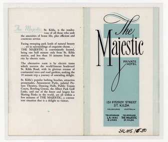
Ephemera - Flyer, Majestic Private Hotel, c1940s
Advertisement for the Majestic Private Hotel, 151 Fitzroy Street St Kilda. The building was constructed in 1912 as a block of flats, designed and built by JR Daley, and was renovated in the 1930s. After a fire in 1981, most of the rear of the building was demolished and replaced by modern apartments.White paper printed in black on both sides, and some teal, and laminatedmajestic hotel, fitzroy street -
 National Wool Museum
Photograph
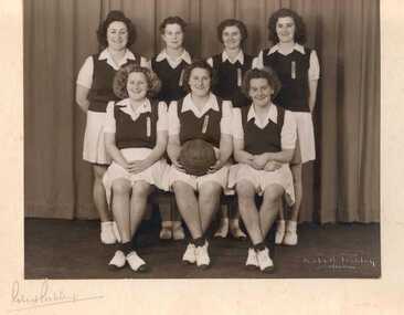
Photograph of the Federal Mills basketball team who were runners up in the A section. Mrs Alsop was a mill worker from early 1930s till early 1970s. She worked at Federal and Foster Mills in Geelong District and Yarra Falls, Melbourne.Robert Pockley / GEELONG Robert Pockley Vicky / Florie Allie / Mavis Nellie / Dot Sheila / N. Alsop 'A' Runners-uptextile mills sporting teams, textile mills staff, federal woollen mills ltd, sport, textile mills - sporting teams, textile mills - staff -
 National Wool Museum
Photograph
Photograph of Federal Mill basketball team players Phyl Bryant and Jess Kemp. Mrs Alsop was a mill worker from early 1930s till early 1970s. She worked at Federal and Foster Mills in Geelong District and Yarra Falls, Melbourne.Phy Bryant / Jess Kemptextile mills sporting teams, textile mills staff, federal woollen mills ltd, sport, textile mills - sporting teams, textile mills - staff -
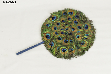 Whitehorse Historical Society Inc.
Accessory - Fan, Hand Screen, 1880 - 1930
Queen Alexandra and Queen Mary were photographed holding these fans.|In 'Feather Fans - Collectors Guide to Fans' by Susan Nayer - 'In1880 feather fans returned to fashion -- remained in use until 1930s at court presentations. Also known as Japanese Fans.`Women's fan. Blue and green peacock feathers in circle. Handle wrapped in blue ribbon. Used indoors beside the fire to protect a ladies complexions against the heat.costume accessories, female -
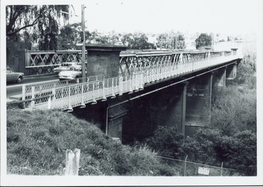 Kew Historical Society Inc
Photograph - Chandler Highway Bridge, 1977
The heritage listed Fairfield Bridge was originally constructed for the Outer Circle Railway to bridge the Yarra River between East Kew and Fairfield stations. In the 1930s it was converted for vehicular traffic. In the 2010s a new concrete bridge was erected beside it to increase vehicular capacity.Print copy of the Chandler Highway Bridge, [formerly the Fairfield Viaduct of the Outer Circle Railway] showing the original position of the walkway beside the bridge. The POV is from the Fairfield side looking towards Kew. CHANDLER HWY BRIDGE OVER YARRA / OCTOBER 1977 / ORIGINALLY BUILT FOR OUTER CIRCLE RWYchandler highway bridge, outer circle railway viaduct, bridges -- kew (vic.) -
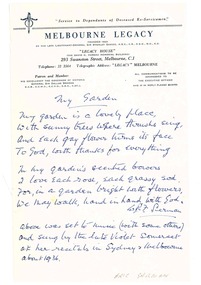 Melbourne Legacy
Document - Poem, Poems by Legatee Eric Serman, 1938
Eight poems written by Legatee Eric Serman on various topics, written in the 1930s. The titles include: The Tree; My Lady; My Garden; In Georgian Days; Sunset at Lakes Entrance and The Gate. Some are on Legacy letterhead. Eric Serman was president in 1928.A record of Legatee Eric Serman a past president of Legacy.Handwritten poems by Legatee Eric Serman - President 1928-29.past presidents, eric serman