Showing 1619 items matching "borough"
-
 Ringwood and District Historical Society
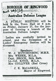
Document - Cuttings and letters, Australian Defence League - Ringwood branch, 1939-1945
Newspaper clippings and correspondence from Australian Defence League and Austraslian Military Forces to Cr. J.K. McCaskill, Borough of Ringwood, regarding speakers and attendance at inaugural local ADF branch, January, 1939. Photocopy of Cr. J.K. McCaskill's Certificate of Authority under War Damage Commission National Security Regulations. Newspaper clipping regarding Austerity War Loan Rally, Ringwood Town Hall, November, 1942. Photocopy of a souvenir - United Service of Thanksgiving (cover only) held in Ringwood Town Hall on 9th May 1945. Ladies are cordially invited to attend, and the formation of a Ladies' Emergency Section will be discussed. Speakers: W.J. Hutchinson, M.H.R., Mrs Weber, M.L.A., Capt. Brock, 24th Batt., Lt. Col. Knox, M.L.A., Mrs Colliver (Red Cross); Hon. N.J. Makin, Minister for Navy and Munitions; T.R.G. Williams, Mayor, Chairman, Ringwood War Loan Committee (1942). -
 Bendigo Historical Society Inc.
Document - H.A. & S.R. WILKINSON COLLECTION: CONDITION OF SALE
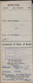
Contract of sale of land issued by H.A. Wilkinson and dated 8th October 1952 between Mrs. Ruby Knopp (seller) and Mrs. D. Richards (buyer) for land situate 10 Sandhurst Road Corner Collins Street California Gully, being south east of and adjoining allotment 566 section M, Borough of Eaglehawk having a frontage of 199 links by a depth of 305 links described in right to occupy residence area No. 5036, together with 5-roomed weatherboard dwelling and all sundry. Price 1,520 pounds.organization, business, h.a. & s.r wilkinson real estate -
 Bendigo Historical Society Inc.
Document - H.A. & S.R. WILKINSON COLLECTION: CONDITION OF SALE
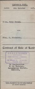
Contract of sale of land issued by H.A. Wilkinson and dated 8th October 1952 between Mrs. Ruby Knopp (seller) and Mrs. D. Richards (buyer) for land situate 10 Sandhurst Road Corner Collins Street California Gully, being south east of and adjoining allotment 566 section M, Borough of Eaglehawk having a frontage of 199 links by a depth of 305 links described in right to occupy residence area No. 5036, together with 5-roomed weatherboard dwelling and all sundry. Price 1,520 pounds.organization, business, h.a. & s.r wilkinson real estate -
 Bendigo Historical Society Inc.
Document - BASIL MILLER COLLECTION: TRAMS - 'RUNNING JOURNAL', April 1970
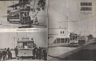
Journal of the Tramway Museum Society of Victoria. Ltd. Volume 7, No. 2. April 1970. Thirty cents, seventeen pages. Front cover (right) took by Mal Rowe. Showing maximum traction bogie car no. 25 of the S.E.C. Bendigo system rumbles over the stone pavement of Mitchell Street bound for the Borough of Eaglehawk. Built in 1917 for the Hawthorn Tramways Trust, the car saw service in Melbourne until 1947 when it was purchased by the S.E.C. History of document: Part of 'Basil Miller Tramways Collection'.document -
 Bendigo Historical Society Inc.
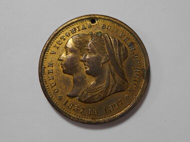
Medal - MEDAL COLLECTION: QUEEN VICTORIA JUBILEE MEDAL, 1897
Object. Brass coloured metal medal with 1mm hole drilled in the top edge. This coin was produced by the Borough of Eaglehawk to commemorate the 60th Jubilee Year of Queen Victoria. E.C.Brown was Mayor at the time. Obverse: In the centre overlapping profile of Queen Victoria at different ages. Around the edge ''QUEEN VICTORIA'S 60TH YEAR OF REIGN 1837 - 1897''. Reverse: Diamond outline around Royal Coat of Arms above an eagle with outstretched wings with mullock heap to the left and factory to the right . Around the edge ''EAGLEHAWK E.C. BROWN. MAYOR 1897''.numismatics, medals - commemorative, queen victoria's jubilee medal 1897 -
 Ballarat Tramway Museum
Document - Letter/s, State Electricity Commission of Victoria (SECV), 1/02/1962 12:00:00 AM
Yields information about the method of advising the City of Ballarat and the Borough of the planned closure of the tram system and the actual advice provided.Letter - four foolscap sheets, each with rounded corners, addressed to the Town Clerk, City of Ballarat and the Borough of Sebastopol, dated 1/2/1962, signed by the Secretary of the SEC D H Munro, advising Councils that the SEC no longer would support the tramways and that the propose to abandon them. Gives a history of the SEC involvement, finances, poor fare returns, time for the TRB to arrange bus replacement, future of the employees, includes Bendigo and Eaglehawk. Fourth sheet lists 11 years of finances and losses. With numbers of passengers carried.Date stamped 2/2/62 and has file number in the top right hand corner in ink.trams, tramways, closure, staff, sec, ballarat, city of ballarat, borough of sebastopol -
 Kew Historical Society Inc
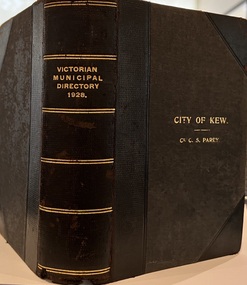
Journal, Arnall & Jackson: Printers & Stationers, Victorian Municipal Directory and Gazetteer : Also Commonwealth Guide and the Water Supply Record for 1928
The Victorian Municipal Directory provided annual details, and later bi-annual details, of all councils. Published by Arnall & Jackson (Printers and Stationers), copies were published in 'cloth' for sixteen shillings and 'half roan' for eighteen shillings. This copy was owned by Cr C.S.Parry. Elected to the Kew City Council as a representative of North Ward, Cr Parry was elevated to the position of Mayor in 1931. It, together with five other editions, was presented to the Kew Historical Society in 1987 by his grandson.Bound copy of the Victorian Municipal Directory and Gazetteer: Also Commonwealth Guide and the Water Supply Record for 1928. The volume contains 846 pages and includes sections on: - Comparative table – Municipal Returns for Twenty-one Years. - Index to Townships, Parishes and Railway Stations. - Changes and appointments. - Commonwealth of Australia (Constitution, Parliament, Departments and Officers). - State of Victoria (Parliament, Departments and Officers / Boards, Institutions, Trusts and Loans). - Municipalities in Victoria (Cities and Towns, Boroughs, Shires). - Water Supply (State Rivers and Water Supply Commission).non-fictionThe Victorian Municipal Directory provided annual details, and later bi-annual details, of all councils. Published by Arnall & Jackson (Printers and Stationers), copies were published in 'cloth' for sixteen shillings and 'half roan' for eighteen shillings. This copy was owned by Cr C.S.Parry. Elected to the Kew City Council as a representative of North Ward, Cr Parry was elevated to the position of Mayor in 1931. It, together with five other editions, was presented to the Kew Historical Society in 1987 by his grandson. victoria -- registers -- periodicals., victoria -- directories., water-supply -- victoria -- directories., municipal government -- victoria -- periodicals., cities and towns -- victoria -- directories. -
 Kew Historical Society Inc
Photograph, Madford, Wellington Street, circa 1965, c. 1965
This work forms part of the collection assembled by the historian Dorothy Rogers, that was donated to the Kew Historical Society by her son John Rogers in 2015. The manuscripts, photographs, maps, and documents were sourced by her from both family and local collections or produced as references for her print publications. Many were directly used by Rogers in writing ‘Lovely Old Homes of Kew’ (1961) and 'A History of Kew' (1973), or the numerous articles on local history that she produced for suburban newspapers. Most of the photographs in the collection include detailed annotations in her hand. The Rogers Collection provides a comprehensive insight into the working habits of a historian in the 1960s and 1970s. Together it forms the largest privately-donated collection within the archives of the Kew Historical Society.‘Elm Lodge’ had a frontage to Wellington Street and extended to Cotham Road. It was renamed ‘Madford’ in 1874, after its purchase by the pastoralist Arthur Septimus King, the grandson of Philip Gidley King, third Governor of New South Wales. The Alexandra Gardens were developed on the northern section of Madford after the sale of the land to the Borough of Kew in 1905. King’s house, and the remaining garden, was sold to the Catholic Church in 1920, and subsequently developed into ‘St Anthony’s Home for Babies’ in 1922. The organisation relocated to Footscray in 1975, and the building demolished."Madford (formerly Elm Lodge) in Wellington Street Kew during the period when it was St. Anthony's Home for babies (now demolished). From the 1860s it had been the home of the King family. Harold Septimus King was one of the notable residents of Kew."madford, elm lodge, wellington street (kew), dorothy rogers -
 Kew Historical Society Inc
Map, MMBW, MMBW Plan No.39 Kew & Heidelberg, 1900-1910
The Melbourne and Metropolitan Board of Works (MMBW) was established by an act of the Victorian Parliament in 1890 to prepare for and to implement a sewerage and water reticulation system across what was then inner Melbourne, its surrounding and middle distance suburbs, including Kew. The MMBW was disbanded in 1991.The map collection of the Kew Historical Society has at its core the historic maps assembled and originally stored in the City Engineer's Department of the City of Kew. These include maps in a number of scales. The vast majority of maps were produced by the MMBW in the first two decades of the twentieth century, and are solid working maps, backed by linen for durability. These maps are historically significant to Kew, the City of Boroondara and to the history of the development of state utilities in Victoria. A number of the Kew maps have additional details added by former municipal officers, including the levels reached by various floods. As these were working documents, information was added to them long after the period of their initial production and distribution.Early map of part of the Borough of Kew, created in the first decade of the twentieth century, at a scale 160 ft to 1 inch. The map covers what was then the north western section of Kew, bordered on its north by Wills Street and the Kew Lunatic Asylum, in the west by the River Yarra [and the later added Yarra Boulevard] , by Princess Street in the East and Holroyd Street in the south. The map shows the extent of urban development by that time, prominent institutions and the outlines of built structures in the municipality. Contour lines were added in ink to the map at a later stage.MELBOURNE AND METROPOLITAN BOARD OF WORKS / PLAN NO. 39 / KEW & HEIDELBERGmelbourne & metropolitan board of works, mmbw maps, mmbw plans, borough of kew, cartography -
 Kew Historical Society Inc
Map, MMBW, MMBW Plan No.67 Kew, 1900-1910
The Melbourne and Metropolitan Board of Works (MMBW) was established by an act of the Victorian Parliament in 1890 to prepare for and to implement a sewerage and water reticulation system across what was then inner Melbourne, its surrounding and middle distance suburbs, including Kew. The MMBW was disbanded in 1991.The map collection of the Kew Historical Society has at its core the historic maps assembled and originally stored in the City Engineer's Department of the City of Kew. These include maps in a number of scales. The vast majority of maps were produced by the MMBW in the first two decades of the twentieth century, and are solid working maps, backed by linen for durability. These maps are historically significant to Kew, the City of Boroondara and to the history of the development of state utilities in Victoria. A number of the Kew maps have additional details added by former municipal officers, including the levels reached by various floods. As these were working documents, information was added to them long after the period of their initial production and distribution.Early map of part of the Borough of Kew, created in the first decade of the twentieth century, at a scale 160 ft to 1 inch. The map covers what was then the north central part of Kew, bordered on its north by the Outer Circle Railway Spruzen and Beresford Avenues, in the west by Princess Street, in the south by High Street, and in the east by (about) Belford Road. The map shows the extent of urban development by that time, prominent institutions and the outlines of built structures in the municipality. Contour lines were added in ink to the map at a later stage.MELBOURNE AND METROPOLITAN BOARD OF WORKS / PLAN NO. 67 / KEW melbourne & metropolitan board of works, mmbw maps, mmbw plans, borough of kew, cartography -
 Kew Historical Society Inc
Map, MMBW, MMBW Plan No.68 Kew, 1900-1910
The Melbourne and Metropolitan Board of Works (MMBW) was established by an act of the Victorian Parliament in 1890 to prepare for and to implement a sewerage and water reticulation system across what was then inner Melbourne, its surrounding and middle distance suburbs, including Kew. The MMBW was disbanded in 1991.The map collection of the Kew Historical Society has at its core the historic maps assembled and originally stored in the City Engineer's Department of the City of Kew. These include maps in a number of scales. The vast majority of maps were produced by the MMBW in the first two decades of the twentieth century, and are solid working maps, backed by linen for durability. These maps are historically significant to Kew, the City of Boroondara and to the history of the development of state utilities in Victoria. A number of the Kew maps have additional details added by former municipal officers, including the levels reached by various floods. As these were working documents, information was added to them long after the period of their initial production and distribution.Early map of part of the Borough of Kew, created in the first decade of the twentieth century, at a scale 160 ft to 1 inch. The map covers what was then the north central part of Kew, bordered in the north by Oak Avenue, in the west by the Yarra River and Connor's Creek, in the south by Beresford and Carnegie Avenues, and in the east by Glass's Creek and Burke Road. The map shows the extent of urban development by that time, prominent institutions and the outlines of built structures in the municipality. Contour lines and the levels of historic floods were added in ink to the map at a later stage.MELBOURNE AND METROPOLITAN BOARD OF WORKS / PLAN NO. 68 / KEW melbourne & metropolitan board of works, mmbw maps, mmbw plans, borough of kew, cartography -
 Ringwood and District Historical Society
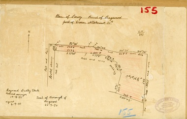
Map, Plan of Survey, Parish of Ringwood - Part of Crown Allotment 31A - 1950
Hand drawn and labelled copy of map with survey measurements of allotment on Isobel Avenue (Isabel Avenue?), Ringwood East. Raymond Dudley Steele Licensed Surveyor 10-8-50, signed 6-9-50, Seal of Borough of Ringwood 26-9-50. Rubber stamp - Dugdale, Simmons & Stevens, Solicitors, Peacock House, 486 Bourke Street Melbourne. Typewritten heading on backing paper - Capt. M.H. Moyes - Correspondence Supplementary to Statements. -
 Warrnambool and District Historical Society Inc.
Document, Gauley contracts .1 & .2, C 1878
In 1858 a tramway was constructed to move goods between Warrnambool township and jetty on Lady Bay which was over a mile away The terminus was established on the southern side of Merri Street. and the track went around the edge of Lake Pertobe reserve. Large stores were also built near where the present railway station is situated to hold produce and carriages. These documents relate to contracts between Marion Gauley ,contractor of Warrnambool and the borough of Warrnambool for the operation of horse work with the tramway. John McDermid sadler,and William Stevens farmer of Russell's Creek are acting as surety for the contract.The tramway was an important part of Warrnambool's infrastructure and history and the documents also include names of local people. Of particular interest is the fact that the contract in this case was given to a woman which would have been a little uncommon at that time.001259.1 Pale blue lined paper with red lined outline.Hand written in black pen with names and some other words underlined in red. Two signatures on bottom right with red seal beside each. Witness signature below on left hand side. One page only 001259.2 Pale blue lined paper with red lined outline.Hand written in black pen with names and some other words underlined in red. Two signatures on bottom right with red seal beside each. Witness signature below on left hand side. Of the four pages of the document , only the first page is used. 001259.1 Signed Roady Carew and Moses Daly. Richard Daly is crossed out in the document and Marion Gauley is inserted in greylead. September 1878 001259.2 John McDermid saddler William Stevens, Marion Gauley. Ninth of December 1878. warrnambool, warrnambool tramway, marion gauley, john mcdermid, william stevens -
 Stawell Historical Society Inc
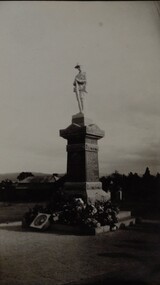
Photograph, Soldiers’ Memorial World War 1 in Main Street -- Different angle
Soldiers’ Memorial World War 1 with wreaths at base. The "Girl's Remembrance League" worked to raise money for the memorial to be built. Cost was 643.0.0 pounds. The memorial was unveiled on Saturday 10th Nov. 1923, by Archdeacon T.P. Bennett, (a respected pardre and old Stawell boy). Photo was copied from original donated by Mrs. L Matthew's whose mother Mrs. A. V. Cornish was a member of the Girls Remembrance League. Memorial was partly built by Robson & Grey, when partnership dissolved Mr. G.M. Robson completed the work. The Borough Council donated the land for the memorial.Black & white photograph of a World War 1. memorial. The fallen soldier statue is on a tiered granite base with flowers and wreaths around the base and steps of the memorial. There are two black & white photos one an enlargement. stawell ww1 -
 Ballarat Tramway Museum
Newspaper, The Courier Ballarat, "Start on removal of the tram lines", 21/9/1971
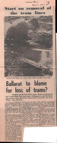
Newspaper clipping and photograph provides two stories about Ballarat Tramways following the last tram on 19/9/1971: 1 - "Start on the removal of the tram lines" - with a photo of welder K Drever of the CRB cutting rails in Sturt St. 2 - A piece, headed "Ballarat to blame for loss of trams?" quoting Mr N R White, SEC Chairman about the lack of willingness for Ballarat residents to use the trams, at the civic reception the previous day. Also quotes Cr. Chisholm, Mayor of Ballarat and Cr. Donald, President of the Borough of Sebastopol.Yields information about the commencement of track removal in Ballarat and the SECV Commissioners view of the tramway closure.Newspaper clipping from The Courier 21/9/1971Has the newspaper source in ink along the top edge.tramways, tramcars, secv, closure, tram track removal -
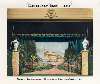 Bayside Gallery - Bayside City Council Art & Heritage Collection
Photograph - hand-coloured photograph, Brighton Centenary Year, Stage decoration, Mayoral Ball, c. 1959
This work was presented to The Mayor and Mayoress, Cr. and Mrs R.G. Ward, by the citizens of Brighton to commemorate the Brighton Centenary in 1959. Brighton was first incorporated as a borough on 18 January 1859, it became a town on 18 March 1887 and was proclaimed a city on 12 March 1919. The new Brighton Municipal Offices were designed by Kevin Knight of Oakley and Parkes with the engineers John Connell and Associates and were erected by Prentice Builders Pty Ltd. The foundation stone was laid on 13 February 1959 and the building was opened on 21 July 1961. The interior decoration and furniture was by Grant Featherston.brighton centenary, brighton town hall, stage decoration, mayoral ball, brighton municipal offices, civic centre, oakley and parkes, kevin knight, r.g. ward, mayor -
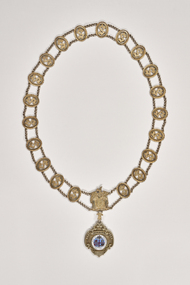 City of Greater Bendigo - Civic Collection
Ceremonial object - Shire of Strathfieldsaye Chain with President medallion, unknown
Strathfieldsaye was first incorporated as a road district on 20 August 1861, and became a shire on 17 September 1866.Strathfieldsaye Council was suspended on 20 July 1993, with a commissioner appointed, after allegations of the council being divided and unworkable.On 7 April 1994, the Shire of Strathfieldsaye was abolished, and, along with the City of Bendigo, the Borough of Eaglehawk, the Rural City of Marong and the Shire of Huntly, was merged into the newly created City of Greater Bendigo. (source Wikipedia). Strathfieldsaye was divided into three wards, each of which elected three councillors; Axedale Ward, Mandurang Ward, Strathfieldsaye Ward. The Shire of Sthrathfieldsaye President's chain was manufactured by P. Blashki and Sons in Stirling silver with a 22ct gold plated finish. Consisting of 20 links, the centre piece depicts the Australian Coat of Arms and drop features an enameled Shire of Strathfieldsaye coat of arms. President / Shire of Strathfieldsaye / Victoria / 1866 / Dieu et mon droit / PROGRESS / 1866city of greater bendigo ceremonial item, shire of strathfieldsaye, president of strathfieldsaye shire -
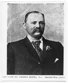 Tarnagulla History Archive
Photograph: copy of news image of George Minto, c. 1870s
Murray Comrie Collection. George Minto (b.1824 in Harwick, Scotland) was engineer at the Flour Mill in Tarnagulla, was Mayor of Tarnagulla Borough Council for a time and was engineer of the Shire of Marong for twenty years. For 13 years he occupied the position of surveyor to the Bendigo City Council. In his later life he lived in Kangaroo Flat. Whilst living there, on the 28th November 1914, he died, aged 90 and a half years. This photograph is a reasonable image created from a historic news source (unknown). Copy probably made by Murray Comrie in the 1970s.Monochrome photograph, being copy of a news clipping with image of George Minto. Printed caption 'The Late Mr. George Minto, Jun. (Bartlett Bros, photo)'. tarnagulla, people -
 Bendigo Historical Society Inc.
Map - CAMPBELL COLLECTION: BENDIGO AND DISTRICT MAPS, 1982
Map. Forest Commission Victoria, Bendigo Forest District, Sub-Plan 1 District Fire Prevention Plan, Greater Bendigo Area. Prevention Strategy Plan. Shire of Marong, Shire of Huntly, Borough of Eaglehawk, Shire of Strathfieldsaye, Sailors Gully, Epsom, Jackass Flat, White Hills, California Gully, Maiden Gully, Long Gully, North Bendigo, City of Bendigo, Bendigo East, Kennington, West Bendigo, Golden Square, Quarry Hill, Flora Hill, Spring Gully, Kangaroo Flat.Base prepared 1982. (number 397 in map cupboard 1)map, bendigo, forest district -
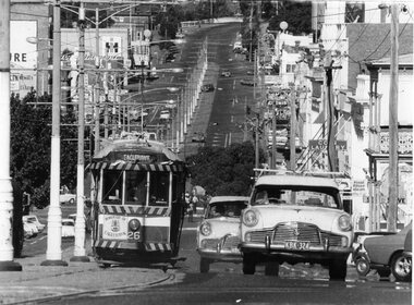 Ballarat Tramway Museum
Photograph - Black & White Photograph/s, Herald Sun, 16/04/1972 12:00:00 AM
Yields information the operation of Bendigo trams in View St Bendigo, on the Eaglehawk route, and the delivery of the tram to Eaglehawk following closure.Black and White photograph of Bendigo No. 26 climbing View St, Bendigo with the destination of Eaglehawk and a "Borough of Eaglehawk sign" on the front dash panel. Photo taken with a large telephoto lens to show up the hill. Has Mitchell St in the background and a number of cars in the foreground. Photo taken on the last day of operation - used in Keith Dunstan's "A Place in the Sun" 17/4/1972. Herald Sun newspaper photograph. Printed on Agfa paper. For a copy of the newspaper article see Reg. Item 2229. See A Place in the Sun 17/4/1972.On rear in ink "ED15/215" and "17/4/72" in ink and a "Herald Sun Newspaper copyright" stamp - very faint green ink.tramways, trams, bendigo, eaglehawk, closure, view st, tram 26 -
 Kew Historical Society Inc
Map, MMBW, MMBW Plan No.40 Collingwood & Kew, 1900-1910
The Melbourne and Metropolitan Board of Works (MMBW) was established by an act of the Victorian Parliament in 1890 to prepare for and to implement a sewerage and water reticulation system across what was then inner Melbourne, its surrounding and middle distance suburbs, including Kew. The MMBW was disbanded in 1991.The map collection of the Kew Historical Society has at its core the historic maps assembled and originally stored in the City Engineer's Department of the City of Kew. These include maps in a number of scales. The vast majority of maps were produced by the MMBW in the first two decades of the twentieth century, and are solid working maps, backed by linen for durability. These maps are historically significant to Kew, the City of Boroondara and to the history of the development of state utilities in Victoria. A number of the Kew maps have additional details added by former municipal officers, including the levels reached by various floods. As these were working documents, information was added to them long after the period of their initial production and distribution.Early map of part of the Borough of Kew, created in the first decade of the twentieth century, at a scale 160 ft to 1 inch. The map covers what was then the south western section of Kew, bordered on its north by Studley Park Road, in the west by Walmer Street and the River Yarra, by High Street South and Princess Street in the East and Barkers Road in the south. The map shows the extent of urban development by that time, prominent institutions and the outlines of built structures in the municipality. Contour lines and historic flood levels were added in ink to the map at a later stage.MELBOURNE AND METROPOLITAN BOARD OF WORKS / PLAN NO. 40 / COLLINGWOOD & KEWmelbourne & metropolitan board of works, mmbw maps, mmbw plans, borough of kew, cartography -
Ringwood and District Historical Society
Document, Packet: Ringwood Traders Association- Ringwood Carnival Committee, 1934. Newspaper cuttings 1958, 1934
Miscellaneous documents and newspaper cuttings.Packet includes: . Typed and hand written correspondence to Borough of Ringwood from Ringwood Traders Carnival Committee re Xmas Carnival, 1934. . Newspaper cuttings with images at Ringwood Lake Carnival with the Mayor Cr. Peter Vergers, 30/1/1958. . Newspaper cutting from the 'Mail' dated 27/3/1958 showing Leslie Caird, Queen of Cycling. -
 Warrnambool and District Historical Society Inc.
Administrative record - Town of Warrnambool Ledgers, Thomas Beattie, Warrnambool Rate Collector, early 20th century
These are two administrative record books from the Warrnambool Town Council which took over from the Warrnambool Borough Council in 1883 and existed until 1918 when it became the Warrnambool City Council. .1 Warrnambool Town Council letter book dating from 1904 to 1918 containing copies of letters written by the Rate Collector, Thomas Beattie .2 Warrnambool Town Council Contract Book dating from 1902 to 1909. The contract details include the name of the supplier or tradesman and the costs. Some of the contracts deal with the Corporation Baths, the Botanic Gardens and town tree planting. These record books are of historic interest as they include many projects in Warrnambool and the names of local people from early in the 20th centuryThese are two administrative record books from the Town of Warrnambool Council. .1 Letter Book with a blue cover and a pasted label and a brown leather spine and leather edging on the corners. The pages include an alphabetical index at the front of the book. .2 Ledger with a dark green cover and leather binding on the spine and the edges of the cover. The spine has red and brown leather labelsTown Of Warrnambool Contract Bookwarrnambool town council, thomas beattie warrnambool rate collector -
Clunes Museum
Weapon - NAVAL CANNON, 1847
IT IS ON PERMAMENT LOAN FROM HEPBURN SHIRE THE CANNON WAS ORIGINALLY ON THE BRITISH NAVAL SHIP "NELSON" IN FEBRUARY 1867. "NELSON" WAS HANDED OVER TO THE VICTORIAN NAVAL FORCES, ON LOAN FROM THE ROYAL NAVY. "NELSON" WAS SOLD 1898, IT IS BELIEVED THAT THE GUNS WERE THEN OFFERED FOR SALE TO COUNCILS. IT WAS DISPLAYED ON A SITE NEAR THE SCENIC ROAD, CLUNES, UNTIL THE WOODEN UNDERCARRIAGE WAS DESTROYED BY THE BUSHFIRES IN 1944. IT WAS LATER RETRIEVED AND KEPT IN THE CLUNES BOROUGH COUNCIL YARD UNTIL IT WAS RESTORED BY THE APPRENTICES AT THE BENDIGO ORDNANCE WORKSHOPS IN 1895. THE TIMBER USED FOR THE RESTORATION WAS TAKEN FROM AN ELM TREE NEAR THE CREEK IN CLUNES..1 NAVAL CANNON MOUNTED ON A WOODEN UNDERCARRIAGE. .2 CANNON BALLlocal history, military history, navy, military -
 Ballarat Tramway Museum
Map, Electric Supply Co. of Vic (ESCo), Ballarat Electoral Map - ESCo, 1900
Document prepared by the Electric Supply Co of Victoria, as part of an order under the Electric Light and Power Act 1896, section 5 of order No. 17 granted to company. Dated 19/2/1901 and signed by the Postmaster-General. Shows the order area being parts of the City of Ballaarat, Sebastopol and Ballarat East. Shows the street names, boundaries, principal power line routes, land reserves, parks, mine locations, railways and Lake Wendouree. Signed by R L Williams Town Clerk City of Ballarat, J R Hall for the Borough of Sebastopol, and John Gent for the Town of Ballarat EastYields information about the power supply to the Ballarat area.Cloth backed paper map, coloured and marked up as exhibit 17.Notes in ink including the signature of Benjamin Deakin 24/9/00 and certified by the three involved municipal Town Clerks.ballarat power supply, esco, electric supply co of victoria, city of ballaarat, east ballarat, sebastopol, orders, power lines, power supply -
 The Beechworth Burke Museum
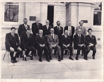
Photograph, 1973
Taken in 1973, this photograph features 13 men in suits, most of whom are council members of the United Shire of Beechworth, as well as a secretary and engineer. The photo is taken in a formal setting, suggesting there may have been an occasion at this time (potentially surrounding or related to the August council meeting). Previously a district (1856), then a borough (1863) and separate shire (1866) at this time the Local Government Area (LGA) had been known by this name for approximately two years, after having amalgamated with the still-existing borough. Beechworth amalgamated with Rutherglen and Chiltern Yackandandah to become the Indigo Shire Council in 1994. Little has been found about the men in the photograph, however this was at also around the time that women were becoming more widely accepted into positions on Victorian council (such as Valerie Mason, who was elected the first President of the United Shire of Beechworth council 6 years after this photograph.) The photograph has been taken in front of the Beechworth Shire Hall. The Hall was designed by architects J.J. Coe and Thomas Dalziel and is dated to 1859. Originally the building was used as the Shire Offices but also doubled as a fire station and a courthouse, with still surviving cells underneath. The Town Hall is now home to the Visitor Information Centre, is the starting point for historical Precinct walking tours and is available for hire for events or community meetings.The Beechworth Town Hall is one of five distinctive granite buildings on Ford Street that comprise the Justice Precinct, and is listed on the Victorian Heritage register. This photograph captures the ongoing importance and use of the Beechworth Town Hall and its ties to Council operations in the 1970s.Black and white rectangular photograph print matt photographic paperReverse - written in pencil upper right corner: 1997.2602; stamped in black ink across centre margin: Beechworth shire council Aug.1973/ Crs.H.H.Warner, H.C.Lucas, L.W. Powell, L. Leentjes, R.C. Sewell, T.J. Carroll/ G.Gray (Secry), Crs.R.P. O'Connor, D. Nankervis, D. McKenzie-McHaig, J.J. Macaulay, H.R. Sinclair/ D.Pope (Engineer), Absent Cr.J.V.Diffey; written in pencil in cursive lower left margin: Absent J Diffey; written in pencil bottom right edge: BMMA02602beechworth shire council, crs.h.h.warner, h.c.lucas, l.w. powell, l. leentjes, r.c. sewell, t.j. carroll, g.gray (secry), crs.r.p. o'connor, d. nankervis, d. mckenzie-mchaig, j.j. macaulay, h.r. sinclair, d.pope (engineer), cr.j.v.diffey, beechworth town hall -
 Glenelg Shire Council Cultural Collection
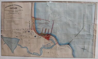
Work on paper - Drawing No. 2, Plan Shewing Works Recommended by Sir John Coode, 1879
Drawing of Portland Bay showing the proposed harbour. Portland town centre is shown as it Portland Botanic Gardens and Battery Hill.Top left: Victorian Harbours / Portland / Plan Shewing Works Recommended by / Sir John Coode / in his report dated Dec r 1879 / The proposed works shown by red colour / the extensions to be undertaken in the first instance across by red colour / subsequent extensions and reclamations are coloured brown Top Right: Drawing No. 2 Portland Borough Council stamped top leftportland harbour, sir john coode, portland, plans, drawings, 1800s -
 Ringwood and District Historical Society
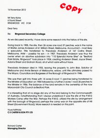
Document - Folder, Brief history of the Ringwood Secondary College site in Bedford Road, Ringwood, Victoria, since 1905 and subdivision in 1924
Terry Kane and Richard Carter were the authors of the short historyType written notes and plans pertaining to the land titles and history of the Ringwood Secondary College site from 1905, prior to the land being sold by the Borough of Ringwood in 1954 to the Education Department. Transcript of covering letter from Richard Carter to Mr T Kane dated 16 November 2012 - "Re: Ringwood Secondary College As we discussed recently, I have done some research into the history of the site. Going back to 1905, the site, then 26 acres one rood 37 perches, was in the name of Walter James Anderson of 61 William Street, Melbourne, Accountant - most likely a speculator. Title transferred to Theodosia Anderson of 167 Collins Street, Melbourne, Artist - possibly his son - In 1907. Theodosia Anderson was thus the owner when on abortive subdivision Into "110 Splendid Home Sites" as "Bedford Park Estate, Ringwood" took place In 1924, creating Anderson Street, Joyce Street, Adams Street and Graham Road, all of which sank without trace. Theodosia Anderson died In 1933, leaving the property to John Blair, Solicitor of Melbourne and Annie Benson of Melbourne, widow, until title ultimately passed to The Mayor, Councillors and Burgesses of the Borough of Ringwood In 1946. Title was then spilt Into three with 14 acres 0 rood 11 perches being transferred to the Minister of Education on 1954 followed by a further 2 acres 1 rood 26 perches to the Minister In 1956. The balance of the land remains In the ownership of the now Maroondoh City Council as Bedford Park. It Is Interesting that at no stage did any of the land belong to the Commonwealth of Australia, notwithstanding that I always understood It was the site of the P.M.G. Workers Camp after the War. Perhaps the P.M.G. utilized the site by arrangement with the borough of Ringwood; perhaps the camp was on the opposite site of Hill Street (Government Road). More research Is needed on this point. Yours faithfully, CE CARTER & SON PTY LTD Richard Carter Managing Director" -
 Warrnambool and District Historical Society Inc.
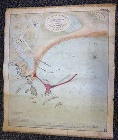
Map - Warrnambool Port 1879, 1879
The port facilities in Warrnambool Bay were in constant use from the first years of Warrnambool’s settlement but there were also difficulties for the shipping trade – a small and unsafe anchorage, the lack of loading facilities and little natural protection from the southerly gales. From the 1870s on there was local agitation for some sort of Breakwater to be built and an Andrew Kerr design was approved by the Warrnambool Council but no funds were made available from the Victorian Government. Throughout the 1870s the building of a Breakwater was a major political issue in the district with preliminary work being funded and started in 1874. In 1879 the Government agreed to a further inspection of the area and an official report. Sir John Coode (1816-1892) was commissioned to make this report. He had come to Australia in 1872 to advise on harbour construction. Coode recommended a 1800 feet long Breakwater and wharf connected to the shore and it was this proposal that the plan described herein and drawn up in 1879 was to accompany. The original plan was eventually modified because of the cost and a Breakwater was completed in 1890 under the direction of the engineer, Arthur Dudley Dobson, with extensions early in the 20th century. This plan is of great interest as it shows in simple graphic form the original plans proposed by Sir John Coode for the Warrnambool Breakwater. It is therefore of great historical importance. The Breakwater was not the maritime success that it was hoped it would be but it is today a significant feature of our foreshore. This is a Plan drawn up in 1879 by Victorian Harbours to accompany Sir John Coode’s Report on the proposed Warrnambool Breakwater. The chart detail is hand-drawn and hand-tinted on canvas with the names of places, geographical and marine features and local points of interest added in print. The edges of the chart are rubbed and the chart is somewhat faded and dirty but the main colours of red, green and brown are still clearly discernible. The title of the plan is printed in an oval inset at the top of the chart. The plan shows two possible Breakwater designs, one from the Borough Surveyor (Andrew Kerr?) and one from Sir John Coode.Victorian Harbours Warrnambool Plan to accompany Sir John Coode’s report Dated 28th Feby 1879 warrnambool breakwater, andrew kerr, sir john coode, arthur dudley dobson, warrnambool, warrnambool harbour, warrnambool history, warrnambool beach -
 Ballarat Tramway Museum
Document - Letter/s, Lloyd Jenkins, Apr. 1999
Copy of letter to the Secretary (Original with Secretary and copy to Alan Bradley) from Lloyd Jenkins accompanying the donation of history of the Borough of Sebastopol (see Reg. Item 1090), along with notes discussing the reason for the tram track to Sebastopol crossing from one side of Albert St. to the other near Trinity Church and other stories of the tramway. The water supply dam for the Star of the East dam was in the way. Also comments regarding Fares Please! Has date received stamp in top right hand corner. Part of letter in May 1999 Fares Please! See May 1999 Fares Please!In top right hand corner, btm date received stamp and correspondence number.trams, tramways, sebastopol, albert st, star of the east, stories