Showing 1188 items matching "east family"
-
 Lakes Entrance Historical Society
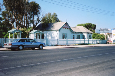
Photograph - Historic House, Fish, Marie, 2002c
This building was the home of the Carpenter family for about 80 years, converted to a restaurant known as 'Skippers', relocated as a private residence in 2003, whole lot demolished to make way for the Lakes Entertainment Centre.|This is the before paired photograph used in the 150 year Lakes Entrance 1858-2008 display.|The after paired photograph number is 01447.1|Also one 12 x 16 framed photograph used in room display.Colour photograph of a weatherboard building on Esplanade. The building has an iron roof, picket fence at front. Carpenters Holiday Centre sign to east of building. Motor vehicle parked on street. Lakes Entrance VictoriaCarpenters Holiday Centre houses, room display, local history -
 Port Melbourne Historical & Preservation Society
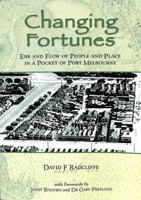
Book, David Radcliffe, Changing Fortunes, March 2021
"Ebb and flow of people and places in a pocket of Port Melbourne " Also contains many references throughout the book to PMHPS collectionWhat it was like to live around the upper reaches of the former Sandridge Lagoon from pre settlement times up until the 1940s. It locates the history of many families who built their dreams on a pocket of reclaimed land in Port Melbourne in the 1880s "Ebb and flow of people and places in a pocket of Port Melbourne" Soft cover book. Green in colour with images of aerial photo of port Melbourne on front and back covers. On back page "once as it was - Boon Wurrong Foundation" yalukit willam, boon-warrung, george beazley, anne chaffey, swallow & ariell ltd, port melbourne town hall, sandridge lagoon, business and traders - milkbars, spring street, esplanade east, built environment - commercial, built environment - domestic, domestic life -
 Stawell Historical Society Inc
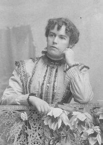
Photograph, Mrs Edith Alice Huttley nee Martin
Huttley - Martin FamilyB/w Studio: Young Woman -pensive. On faux balcony with flowersMelbourne "Eden" Sydney superior Platinotype Edith Alice Martin m Alfred Huttley (my mother) RAT EAST A A II AIhuttley, martin -
 Ringwood and District Historical Society
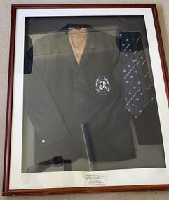
Clothing, East Ringwood Football Club Premiership Blazer 1974 and ties
... and the Clive Fairbairn Rapier Bats tie. Donated by the Ferguson family ...Includes the first VFL Park tie, first Sydney Swans tie and the Clive Fairbairn Rapier Bats tie. Donated by the Ferguson family. -
 Ringwood and District Historical Society
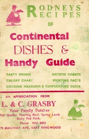
Booklet, Grasby, L. and C, Rodney's Recipes of Continental dishes and Handy Guide. From Your local Butcher (L & C Grasby, 78 Railway Avenue, East Ringwood, WU 6003) c1960, c1960
Given to customers of L. and C. Grasby, Your Family Butcher, 78, Railway Avenue, East Ringwood.Roney's Recipes of Continental Dishes and handy Guide of party drinks, calorie chart, dietetic charts, sporting facts, cooking measures and temperature guide.10 page booklet plus cream coloured covers with red and green printing on both sides. Contains recipes for various occasions, drinks, charts, cooking measures and temperature guide. Given to customers of the butcher. Covering letter from Mrs. Ives +Additional Keywords: Grasby / Ives, Mrs. Norma. All the Ives family lived at 2 Lois Street, East Ringwood until moved away, except for the eldest Ted and his daughter Lynda who lived at 4 Lois Street. -
 Bacchus Marsh & District Historical Society
Map, Atkins and Clarke Land Sale situate at Bacchus Marsh 1856 Copy 2
This plan of land allotments for sale indicates the property once owned by the Bacchus family in and around the township area of Bacchus Marsh. The Bacchus family sold their property in Bacchus Marsh to John Atkins and Robert Nalder Clarke in March 1851. Atkins and Clarke kept the property for a number of years until April 1856 when these allotments were put up for sale.This plan is almost identical to another copy held by the Bacchus Marsh and District Historical Society, VC Record 707, BMDHS collection). This plan, VC Record 452 Copy 2, contains a less detail than than VC Record 707 Copy 1. For example the selling agents and the surveyor who created the plan are not indicated on this copy of the plan. This copy of the plan does indicate the name Crook Street on the map. As the Crook family were the buyers of the Manor House property and surrounding land from Atkins and Clarke in 1856 it suggests that this copy is a later one of the earlier version. It is unlikely that the Crook family would have had the adjacent street named after them prior to purchasing the house and property. This is a very early land sales plan for the township of Bacchus Marsh and it therefore provides some clues as to how the early urban development of the township took place. Upon seeing the map in 1911 Bacchus Marsh Express newspaper editor Christopher Crisp wrote "The sale appears to have created the present township, which had a nucleus in earlier times further east", Express, 30 September, 1911, page 3. A single page paper map showing a portions of land available for sale in Bacchus Marsh in 1856. The subdivided land shown was owned by John Atkins and Robert Nalder Clarke, but previously owned by the Bacchus Family and was in and around their Manor House (Mansion) property in Bacchus Marsh.There are 5 portions of land further divided into numerous small portions. The land for sale is bounded by the present day streets of Main Street, Young Street, McFarland Street, Morton Streets, Crook Street, and part of the eastern section extends to the Lerderderg River. Scale: 4 chains to 1 inch. The map is pasted into a bound volume containing 76 maps or plans in total. High resolution digital image stored on BMDHS computer network. Plan of the first portion of land. The property of Messers Atkins and Clarke situate at Bacchus Marsh.land sales, land sales bacchus marsh, manor house bacchus marsh, crook family bacchus marsh -
 Linton and District Historical Society Inc
Photograph, Streetscape, Sussex Street, Linton, Railway Hotel, James Nelson Undertaker, Linton Public Library
Photograph taken after 1901 as James Nelson took over his family's undertaker's business in that year.This is a cropped version of a photograph (Registration no. 338) which shows both east and west sides of Sussex Street. The photograph has been mounted on card (for use at LDHS exhibition, 1983). This version of the photograph (showing Sussex St east side) is also Mounted photo 444.sussex street linton, railway hotel linton, james nelson undertaker, linton public library -
 Lakes Entrance Historical Society
Book, East Gippsland Historical Society, The Growing of Hops in the Mitchell and Tambo Valleys, 1983
An account of hop growing industry in the Mitchell and Tambo Valleys, Gippsland, Victoria, from commencement c.1869 to the decline and demise in 1916. Includes biographical details of families in the industry, setting up of gardens, hop pickers.industrial -
 Eltham District Historical Society Inc
Photograph - Digital Photograph, Alan King, Busst House, cnr Silver Street and Kerrie Crescent, Eltham, 2 February 2008
Considered the best of the early mud-brick houses built by Alistair Knox. Covered under Heritage Overlay, Nillumbik Planning Scheme. Published: Nillumbik Now and Then / Marguerite Marshall 2008; photographs Alan King with Marguerite Marshall.; p143 The Busst house hidden by trees at the corner of Silver Street and Kerrie Crescent is considered the best of the early mud-brick houses built by Eltham architect, Alistair Knox. Knox himself said, that the Busst house was the most mature mud-brick house designed at that period. ‘It related with true understanding to its steep site and expressed the flexibility of earth building ………to develop a new sense of flowing form and shape’. Built in 1948 for artist Phyl Busst, a former art student at Montsalvat, the house helped usher in Eltham Shire’s distinctive mud-brick residential character. Knox was the pivotal figure of the style developed from the 1950s to the 1970s. Scarcity of building materials after World War Two encouraged mud-brick building because earth was a cheap and plentiful building medium. But when Knox began building in mud-brick in 1947, no council in Victoria knew anything of this ancient art and he needed a permit. Fortunately the Commonwealth Experimental Building Station at Ryde in NSW, had been experimenting with earth construction to help overcome the shortages of that time. They published a pamphlet that became available in Melbourne on the same day the Eltham Council was to consider whether the earth building should be allowed. Knox caught one of the three morning trains to the city in those days and bought several copies of the pamphlet to give to each councillor. On his return he found the councillors standing on the steps of the shire offices after lunch at the local hotel. He heard that earth building had been discussed before lunch and that they were not in favor of it. Knox gave each councillor a pamphlet. They passed that plan and by doing so, opened the door for all future earth building in Victoria and by default, in Australia. Mud-brick houses attracted artists to Eltham, for their aesthetic appeal and because they were cheap. Those who built their own houses, included film maker Tim Burstall, artists Peter Glass, Clifton Pugh, Matcham Skipper, Sonia Skipper and husband Jo Hannan. For Knox, mud-brick building was more than just a cheap building medium. He saw it as harmonising with the surrounding bush and as a way of counteracting the growing materialism of the age. He wrote of its impact on ‘ 20th century man. It should counteract the confusion that the perpetual flow of high technology products have upon him ..’ Building the Busst house on a steep site was difficult because most earth-moving equipment was then in its infancy. For instance drilling for explosives was done by hand, which was a slow and painful process. Knox, assisted by his foreman Horrie Judd and Gordon Ford (who was to become a famous landscape designer), built two large main rooms - a living room/ kitchen downstairs - and upstairs, a studio/bedroom. The studio/bedroom opens onto the balcony, which covers the living area. The bath made of solid concrete by stonemason Jack Fabro, is particularly deep. Sunshine pours through the three French windows of the north-east facing kitchen/living area, which is lined with timber. The large hearth can fit a family around the fire while the timber floors and solomite (compressed straw) ceilings add to the cosy atmosphere. The garden is thick with trees, and in the late 1990s, Ford put in a pool near the original dry wall he had built as a young man.This collection of almost 130 photos about places and people within the Shire of Nillumbik, an urban and rural municipality in Melbourne's north, contributes to an understanding of the history of the Shire. Published in 2008 immediately prior to the Black Saturday bushfires of February 7, 2009, it documents sites that were impacted, and in some cases destroyed by the fires. It includes photographs taken especially for the publication, creating a unique time capsule representing the Shire in the early 21st century. It remains the most recent comprehenesive publication devoted to the Shire's history connecting local residents to the past. nillumbik now and then (marshall-king) collection, alistair knox, alistair knox design, busst house, kerrie crescent, mudbrick construction, mudbrick houses, silver street -
 Eltham District Historical Society Inc
Photograph - Digital Photograph, Alan King, Alistair Knox Park, Eltham, 2008
Alistair Knox Park, an oasis of peace and beauty. Covered under National Trust of Australia (Victoria) Landscape Significance and Heritage Overlay, Nillumbik Planning Scheme. Published: Nillumbik Now and Then / Marguerite Marshall 2008; photographs Alan King with Marguerite Marshall.; p173 It is hard to imagine that the Alistair Knox Park, an oasis of peace and beauty beside busy Main Road, Eltham, was once the township’s rubbish dump. It was only in the 1970s that the tip was transformed into this beautiful six hectare space, which later earned it a National Trust Landscape classification. Before its life as a dump, the area was used for small farms. Thanks largely to the foresight and efforts of local environmental builder Alistair Knox, the park was designed sympathetically with the character of the wider Eltham landscape. Then, appropriately, the park was named after Knox, who was an Eltham Shire Councillor from 1971 to 1975 and Shire President in 1975. The park designers were four major forces in the urban bush landscape garden –Knox, landscape designer Gordon Ford, artist Peter Glass and landscaper Ivan Stranger. The National Trust citation for the park, originally called Eltham Town Park, includes the Eltham railway trestle bridge and the Shillinglaw Cottage. The citation states ‘the semi-natural setting of the parkland provides a landscape which is evocative of the history of the area’. Manna Gums (Eucalyptus viminalis) and Candlebarks (Eucalyptus rubida) are significant features. Most of the park’s construction was directed by Bob Grant, Superintendent of the Parks and Gardens Department for the Eltham Shire Council. First plantings occurred in Arbour Week in 1973, then the lake and botanic area were completed in 1975, with Federal Government funding, and the toilet block in 1978. Bounded by the Eltham railway line, Panther Place, Main Road, Bridge and Susan Streets, the park is in a valley about a kilometre wide overlooked by steep hills at the east and west. The Diamond Creek flows through it and the picturesque historic timber trestle railway bridge edges the north. Informal plantings of Australian indigenous and native species in open and undulating grassed settings blend with the natural landscape of the Diamond Creek to the west. The bush-style plants, particularly around the creek, balance with open lawns, paths and a cascade flowing from a small lake to another below. A footbridge over the creek leads to the park’s west. The park includes an adventure playground and barbecue areas. The park stands on part of the land bought from the Crown in 1851 by Josiah Holloway, who subdivided it into allotments and which he called Little Eltham. Most of the land was subdivided into residential lots, but the creek valley, on which the park stands, was subdivided into farm-size lots, used mainly for orchards and grazing. One of the earliest owners was John Hicks Petty, who in 1874 bought a plot from Holloway. Other families who owned properties in that area, included Rees, Clark, Waterfall, Graham, Hill and Morant. In 1901 the railway was built through the area. Jock Read, an Eltham resident since around 1920, remembers several farms in the 1920s and ’30s that occupied the site of today’s park. A poultry farm, which extended from present day Panther Place, was owned by the Gahan family. Next to that farm was another for grazing cattle owned by Jack Carrucan. Beside this was land owned by John Lyon. A doctor lived beside this, and at the north-west corner of Bridge Street and Main Road stood a memorial to the soldiers who died in World War One, which was later moved to the RSL site. Mr Read also remembers other farms and orchards west of the creek In the early 1960s the Eltham Council began buying these farms and in the late 1960s turned the areas east of the Diamond Creek into a garbage tip. When this was filled above the creek’s flood plain, the tip was moved to the west of the creek.This collection of almost 130 photos about places and people within the Shire of Nillumbik, an urban and rural municipality in Melbourne's north, contributes to an understanding of the history of the Shire. Published in 2008 immediately prior to the Black Saturday bushfires of February 7, 2009, it documents sites that were impacted, and in some cases destroyed by the fires. It includes photographs taken especially for the publication, creating a unique time capsule representing the Shire in the early 21st century. It remains the most recent comprehenesive publication devoted to the Shire's history connecting local residents to the past. nillumbik now and then (marshall-king) collection, alistair knox park, eltham -
 Eltham District Historical Society Inc
Photograph - Digital Photograph, Alan King, Blue Lake, Plenty Gorge Park, 2008
A quarry was transformed into the Blue Lake. Published: Nillumbik Now and Then / Marguerite Marshall 2008; photographs Alan King with Marguerite Marshall.; p179 The dramatic steep-sided Plenty Gorge lies along the divide of two geological areas, and separates the Nillumbik Shire and the City of Whittlesea. On the Nillumbik side are undulating hills and sedimentary rock, and in Whittlesea, lies a basalt plain formed by volcanic action up to two million years ago. This provides the Plenty Gorge Park with diverse vegetation and habitats, making it one of Greater Melbourne’s most important refuges for threatened and significant species. The park, established in 1986, consists of around 1350 hectares, and extends 11 kilometres along the Plenty River, from Greensborough to Mernda. It provides a wildlife corridor for around 500 native plant and 280 animal species. The area’s plentiful food and water attracted the Wurundjeri Aboriginal people and then European settlers. By 1837 squatters had claimed large runs of land for their sheep and cattle. The Plenty Valley was among the first in the Port Phillip District to be settled - mainly in the less heavily timbered west - and was proclaimed a settled district in 1841.But by the late 1880s, the settlers’ extensive land clearing for animal grazing, then agriculture, depleted the Wurundjeri’s traditional food sources, which helped to drive them away. Many Wurundjeri artefacts remain (now government protected), and so far 57 sites have been identified in the park, including scarred trees, burial areas and stone artefacts. Pioneer life could be very hard because of isolation, flooding, bushfires and bushrangers. Following the Black Thursday bushfires of 1851, basalt was quarried to build more fire-resistant homes. Gold discoveries in the early 1850s swelled the population, particularly around Smugglers Gully; but food production made more of an impact. In the late 1850s wheat production supplanted grazing. In the 1860s the government made small holdings available to poorer settlers. These had the greatest effect on the district, particularly in Doreen and Yarrambat, where orchards were established from the 1880s to 1914. Links with a prominent early family are the remains of Stuchbery Farm, by the river’s edge bounded by Smugglers Gully to the north and La Trobe Road, Yarrambat, to the east. The Stuchberys moved to the valley in 1890, and the family still lives in the area. In 1890, Alfred and Ada first lived in a tent where four children were born, then Alfred built the house and outbuildings around 1896. They planted an orchard, then a market garden, and developed a dairy. The family belonged to the local Methodist and tennis communities. Their grandson Walter, opened the Flying Scotsman Model Railway Museum in Yarrambat, which his widow, Vi, continues to run. Wal was also the Yarrambat CFA Captain for 22 years until 1987. Walter sold 24 hectares in 1976 for development - now Vista Court - and in 1990, the remaining 22.6 hectares for the park. Remaining are an early stone dairy and remnants of a stone barn, a pig sty and a well. Until it was destroyed by fire in 2003, a slab hut stood on the Happy Hollow Farm site, at the southern end of the park. The hut is thought to have been built in the Depression around 1893. This was a rare and late example of a slab hut with a domestic orchard close to Melbourne. Emmet Watmough and his family first occupied the hut, followed by a succession of families, until the Bell family bought it around 1948. There they led a subsistence lifestyle for 50 years, despite encroaching Melbourne suburbia. The Yellow Gum Recreation Area includes the Blue Lake, coloured turquoise at certain times of the year. Following the 1957 bushfires, this area was quarried by Reid Quarries Pty Ltd for Melbourne’s first skyscrapers, then by Boral Australia. However in the early 1970s water began seeping into the quarry forming the Blue Lake and the quarry was closed. The State Government bought the site in 1997 and opened it as a park in 1999.This collection of almost 130 photos about places and people within the Shire of Nillumbik, an urban and rural municipality in Melbourne's north, contributes to an understanding of the history of the Shire. Published in 2008 immediately prior to the Black Saturday bushfires of February 7, 2009, it documents sites that were impacted, and in some cases destroyed by the fires. It includes photographs taken especially for the publication, creating a unique time capsule representing the Shire in the early 21st century. It remains the most recent comprehenesive publication devoted to the Shire's history connecting local residents to the past. nillumbik now and then (marshall-king) collection, blue lake, plenty gorge park -
 Eltham District Historical Society Inc
Photograph - Digital Photograph, Marguerite Marshall, Stuchbery Farm dairy, 14 March 2008
Stuchbery Farm was situated on the Plenty River bounded by Smugglers Gully to the north and La trobe Road, Yarrambat, to the east. Alan and Ada Stutchbery moved to the valley in 1890, first living in a tent where four children were born. Alfred built a home and outbuildings around 1896. They planted an orchard, then a market garden and developed a dairy. Published: Nillumbik Now and Then / Marguerite Marshall 2008; photographs Alan King with Marguerite Marshall.; p179 The dramatic steep-sided Plenty Gorge lies along the divide of two geological areas, and separates the Nillumbik Shire and the City of Whittlesea. On the Nillumbik side are undulating hills and sedimentary rock, and in Whittlesea, lies a basalt plain formed by volcanic action up to two million years ago. This provides the Plenty Gorge Park with diverse vegetation and habitats, making it one of Greater Melbourne’s most important refuges for threatened and significant species. The park, established in 1986, consists of around 1350 hectares, and extends 11 kilometres along the Plenty River, from Greensborough to Mernda. It provides a wildlife corridor for around 500 native plant and 280 animal species. The area’s plentiful food and water attracted the Wurundjeri Aboriginal people and then European settlers. By 1837 squatters had claimed large runs of land for their sheep and cattle. The Plenty Valley was among the first in the Port Phillip District to be settled - mainly in the less heavily timbered west - and was proclaimed a settled district in 1841. But by the late 1880s, the settlers’ extensive land clearing for animal grazing, then agriculture, depleted the Wurundjeri’s traditional food sources, which helped to drive them away. Many Wurundjeri artefacts remain (now government protected), and so far 57 sites have been identified in the park, including scarred trees, burial areas and stone artefacts. Pioneer life could be very hard because of isolation, flooding, bushfires and bushrangers. Following the Black Thursday bushfires of 1851, basalt was quarried to build more fire-resistant homes. Gold discoveries in the early 1850s swelled the population, particularly around Smugglers Gully; but food production made more of an impact. In the late 1850s wheat production supplanted grazing. In the 1860s the government made small holdings available to poorer settlers. These had the greatest effect on the district, particularly in Doreen and Yarrambat, where orchards were established from the 1880s to 1914. Links with a prominent early family are the remains of Stuchbery Farm, by the river’s edge bounded by Smugglers Gully to the north and La Trobe Road, Yarrambat, to the east. The Stuchberys moved to the valley in 1890, and the family still lives in the area. In 1890, Alfred and Ada first lived in a tent where four children were born, then Alfred built the house and outbuildings around 1896. They planted an orchard, then a market garden, and developed a dairy. The family belonged to the local Methodist and tennis communities. Their grandson Walter, opened the Flying Scotsman Model Railway Museum in Yarrambat, which his widow, Vi, continues to run. Wal was also the Yarrambat CFA Captain for 22 years until 1987. Walter sold 24 hectares in 1976 for development - now Vista Court - and in 1990, the remaining 22.6 hectares for the park. Remaining are an early stone dairy and remnants of a stone barn, a pig sty and a well. Until it was destroyed by fire in 2003, a slab hut stood on the Happy Hollow Farm site, at the southern end of the park. The hut is thought to have been built in the Depression around 1893. This was a rare and late example of a slab hut with a domestic orchard close to Melbourne. Emmet Watmough and his family first occupied the hut, followed by a succession of families, until the Bell family bought it around 1948. There they led a subsistence lifestyle for 50 years, despite encroaching Melbourne suburbia. The Yellow Gum Recreation Area includes the Blue Lake, coloured turquoise at certain times of the year. Following the 1957 bushfires, this area was quarried by Reid Quarries Pty Ltd for Melbourne’s first skyscrapers, then by Boral Australia. However in the early 1970s water began seeping into the quarry forming the Blue Lake and the quarry was closed. The State Government bought the site in 1997 and opened it as a park in 1999.This collection of almost 130 photos about places and people within the Shire of Nillumbik, an urban and rural municipality in Melbourne's north, contributes to an understanding of the history of the Shire. Published in 2008 immediately prior to the Black Saturday bushfires of February 7, 2009, it documents sites that were impacted, and in some cases destroyed by the fires. It includes photographs taken especially for the publication, creating a unique time capsule representing the Shire in the early 21st century. It remains the most recent comprehenesive publication devoted to the Shire's history connecting local residents to the past. nillumbik now and then (marshall-king) collection, ada stuchbery, alan stuchbery, dairy, stuchbery farm, farm buildings, yarrambat, plenty gorge park -
 Ringwood and District Historical Society
Document, Certificate of Title - Leslie Mills of Plymouth Road, East Ringwood, Farmer - part of Crown Section 20, Parish of Warrandyte, County of Evelyn - 19th January, 1932
A4 copies of Landata Victoria Historical Search documents - Vol 5781 Fol 1156174.Leslie Mills is now the proprietor of an Estate in Fee-simple subject to the Encumbrances notified hereunder ... 10 acres or thereabouts, together with a right of carriage way over Grandview Grove (later Bemboka Road), Warranwood, Victroia. Transfers include Alexander William Brown of Tooradin, Farmer - 29th October, 1945, (died 25th June, 1957), Probate granted 28th January, 1958, to Alfred Hart Brown of Dandenong, Estate Agent, and Harry Britten Elms of Cardinia, Gentleman (*** See Probate details below) Oliver Burgess, Grandview Grove Ringwood, Florist - 14th May, 1964, Privatus Proprietary Limited, St.Kilda Road, Melbourne - 27th October, 1977, John Patrick Kelly, Company Director and Yvonne Gloria Kelly, Married Woman, joint proprietors, 10th September, 1980 *** Inventory of Real Estate Assets (for Probate purposes 4/10/1957) detailed in Family Genealogy record for A.W. Brown includes: "Grandview Grove, Ringwood Land containing 10 acres or thereabouts situate in Grandview Grove Ringwood being part of Crown Section 20 Parish of Warrandyte County of Evelyn and being the land described in Certificate of Title Volume 5781 Folio 174 on which is erected a 7 room house, a bungalow, shed and 2 glass houses valued by E. Miles, Ringwood - £5077-0-0 -
 Nhill and District Historical Society Inc.
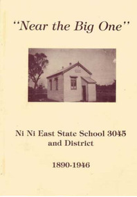
Book - Near the Big One, Graham Schultz, Ni Ni East State School 3045 and District 1890-1946, 1994
History of the Ni Ni East State School 3045 and families in the district from 1890 to 1946Near the Big One; Ni Ni East State School 3045 and District 1890-1946. Soft cream-colored cover, with a picture of the Ni Ni East State School on front. Written and published by the Ni Ni East Reunion Committee, in 1994; 89 pagesnon-fictionHistory of the Ni Ni East State School 3045 and families in the district from 1890 to 1946ni ni east - history, ni ni east state school, australian history, education, rural life -
 Nhill and District Historical Society Inc.
Book - Near the Big One, Near the Big One; Ni Ni East State School 3045 and District 1890-1946
History of the Ni Ni East State School 3045 and the families of the district5 copies of Near the Big One; Ni Ni East State School 3045 and District 1890-1946. Soft cream-colored cover, with a picture of the Ni Ni East State School on front. Written and published by the Ni Ni East Reunion Committee, in 1994; 89 pagesnon-fictionHistory of the Ni Ni East State School 3045 and the families of the districteducation, ni ni east state school, school - history, ni ni east - history, school days, australian history, nhill free press -
 Whitehorse Historical Society Inc.
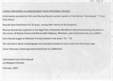
Document - Real estate notes, maps, flyers, Trove Park Estate, 1969, 2022
A history of the Trove Park Estate, Vermont from 1880's to 2022 is provided by notes, maps, pictures and auction flyers. The Estate was originally part of the Uplands Estate of 34 acres in the Mount Pleasant district.A history of the Trove Park Estate, Vermont from 1880's to 2022 is provided by notes, maps, pictures and auction flyers. The Estate was originally part of the Uplands Estate of 34 acres in the Mount Pleasant district.A history of the Trove Park Estate, Vermont from 1880's to 2022 is provided by notes, maps, pictures and auction flyers. The Estate was originally part of the Uplands Estate of 34 acres in the Mount Pleasant district.trove park drive estate vermont, mt pleasant, trove park, uplands vermont, bishop edward, round chris & murray, mulcahy mendelson & round, trove park drive vermont no 7 -
 Bendigo Historical Society Inc.
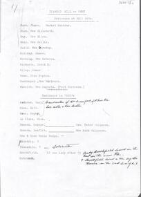
Document - DIAMOND HILL RESIDENTS 1955 AND 1920'S
BHS CollectionTyped 2 page document detailing the residents who lived at Diamond Hill in late 1920's, 1955 and 1981. Names include: Bush, James, market gardener Busyh, Mrs Elizabeth Day, Mrs Ellen Guild, Mrs Dorothy Holiday, James, Hocking, Mrs Rebecca Richards, David H Riley, James, Rower, Miss Sopghie Rushmeyer, Mrs Gertrude Weseloh, Mrs Augusta, Post Mistress Residents in 1920's Ändrews, Mary 9grandmother of Mrs Crawford, McIvor Road, Tweo sisters and their brother are Bill Rowe and ophy Rower. Le Clare, Miss Deason, Zephyr Mulqueen,Mrs Peter, Deason, Leaflet, Mulqueen, Mrs Ruityh Mrs and Miss Mabel Budgte Bidstrip Teasedale, Brookfield, Schrunck Andy Brookfield lived in the tent on the new road. Brookfield lived in the big storehouse on the east side of the road Dempster Bush Herbel, Miss Rose ( Mrs Luke Murphy) Dean, Herman Erwin, Andy Holidays ( 3 families) Wescloh, ( partly indecipherable) Augusta ( post mistress) Mrs Day Schilling, Roy Rushmeyer. (Ruschmeyer) 1981: Bush Rushmeyerbendigo, mining, diamond hill -
 Melbourne Tram Museum
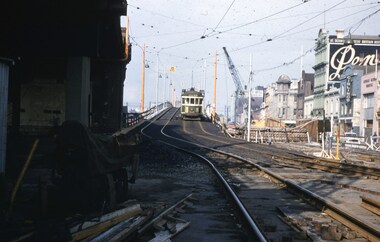
Slide - Set of 4, John Webster, 16/11/1959 12:00:00 AM
Set of four Colour slides, Kodak, white cardboard of trams using the Flinders St overpass of King St, 16-11-59. .1 - W2 538 descending the temporary track over King St as part of the first stage of construction. Tram has the destination of East Kew Route 40. .2 - ditto at the base of the bridge. Tram has adverts for Uncle Toby's Oats, .3 - W5 725 entering the temporary track near Queen St. Tram has destination of Spencer St, route 48 and adverts for 3AW, Pimms No. 1 and Penfolds Wine. On the far right is a MMTB Mk III bus to Kew - Earl St. .4 - ditto with the Yarra Family Hotel in the background. Note the tram stop sign. .In the background are adverts for Penfolds Wines, Bushels, the Flinders St viaduct, Nestles Milk, Girlings Store and the Cafe / Milk bar that was under the viaduct.Hand writing on rear in ink; .1 - 16-11-59 - Melbourne Vic. .2 - ditto ..3 and .4 - 16-11-59 Tram 725 entering temporary track in Flinders St Melbourne Vic.trams, tramways, trackwork, flinders st, king st, track construction, bridges, w2 class, east kew, route 40, w5 class, route 48, tram stops, tram 538, tram 725 -
 Bacchus Marsh & District Historical Society
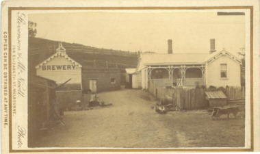
Photograph, Symington Brewery, Hopetoun, near Bacchus Marsh 1883
The family of William Symington arrived in Melbourne in 1855. By 1858 they had come to Bacchus Marsh and built a house at Hopetoun a few kilometres east of the town. A brewery next to the house was also built around this time. It was a licensed brewery between 1862 and 1886. The elder William Symington died in March 1867 and the brewery was then operated by his son the younger William Symington for a number of years. It ceased operations sometime before 1900. Small sepia unframed photograph on card with gold border framing photograph. Housed in the album, 'Photographs of Bacchus Marsh and District in 1883 by Stevenson and McNicoll'. The image shows the brewery and house which belonged to the Symington family of Hopetoun, near Bacchus Marsh. The house is a timber structure with two chimneys and a front verandah. The front yard of the house is enclosed by a timber fence. At the front of the fence can be seen a dog kennel. Other tools, such as a wheelbarrow, lie in the yard. The brewery building is of timber and brick. On the hillside behind the buildings are paddocks fenced with post-and -rail fencing.On the front: Stevenson & McNicoll. Photo. 108 Elizabeth St. Melbourne. COPIES CAN BE OBTAINED AT ANY TIME. On the back: LIGHT & TRUTH inscribed on a banner surmounted by a representation of the rising sun. Copies of this Portrait can be had at any time by sending the Name and Post Office Money Order or Stamps for the amount of order to STEVENSON & McNICOLL LATE BENSON & STEVENSON, Photographers. 108 Elizabeth Street, MELBOURNE. stevenson and mcnicoll 1883 photographs of bacchus marsh and district, breweries, symington family bacchus marsh, william symington 1840-1929, william symington 1802-1867 -
 Melbourne Tram Museum
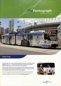
Magazine, Yarra Trams, "The Pantograph", 2007 to 2010
1 - Issue 1 - March 2007 - with photo of the Police Tram (2109) - Welcome message from the CEO Dennis Cliche, Good Friday appeal, Burwood highway works, new sub-stations at Coburg, Royal Park, Brunswick depot, Camberwell depot, East Preston, Essendon, Bundy Clock, Glenhuntly, Kew Depot, Malvern, Southbank,, Safety, events, Lunar Festival .2 - issue 2 - June 2007 - 18 pages, Malvern Depot (a green depot), Paul Matthews profile, trackwork at Glen Huntly and Essendon depots, Depot news, Joyce Barry tribute, Hawthorn depot museum, fund raising. .3 - issue 3 - Octr. 2007 - 16 pages - fund raising - Melbourne city romp, Des Davies retirement, CPR rescue of a collapsed driver, depot news, retirements and a chemical and fire incident on the Vermont South line. .4 - issue 4 - Jan. 2008 - 12 pages - fundraising, family events, depot news, retirements, TramTracker Jake .5 - issue 11 - Winter 2010 - 16 pages - St Kilda Road Superstops, Michel Mason - CEO, Malvern depot centenary, Transformation, new maps on trams, fundraising, the leadership team, depot news, uniforms, South Caulfield Junction upgrade. .6 - 20 pages issue 12, Summer 2010, published soon after Keolis took over operations of Yarra Trams. The first 10 pages, look at Trams on the Fringe, Feedback, Football trams, staff matters, and features a story on page 10 of the Hawthorn Tram Depot museum and Driver Shaun McCarthy wearing the brown uniform in front of tram 1041. Fully Scanned. The second ten pages are reversed (upside down) and titled "Le Pantographer", featuring a Bordeaux tram on the cover. Provides details of Keolis operations such as Lyon, Bordeaux, Lille, Le Mans, Caen, Angers, Dijon and other operations. .7 - issue 6 - Spring 2008 - Meerkats, fleet operations, training, Art Alive, Kew depot - new inspection pits, Long Lay Malvern, Did You Know campaign, and looking for Cricket players - part scanned. .8 - issue 13 - Autumn 2011 - Michel Masson CEO, visit of French Media, Ron Scholten Retirement, photo of Geoff Dean of Camberwell, - part scanned. .9 - issue 5 - June 2008 - Tram works Swanston and Flinders, tram 111, cricket .10 - issue 8 - Autumn 2009 - Good Friday appeal, public transport ombudsman, Malvern centenary, my friend Mike .11 - issue 9 - Spring 2009 - Chris Cairns safety campaign, route 48, Myki, Tramtracker, Jake.Demonstrates Yarra tram staff newslettersEleven issues of Yarra Tram's internal newsletter "The Pantograph", all A4, center stapled. Issues not fully scanned, unless noted.trams, tramways, keolis, yarra trams, fohtd, hawthorn, uniforms, coburg, substation, royal park, burwood highway, fund raising, bundy clock, environment, glenhuntly depot, essendon depot, malvern depot, south caulfield, tram 2109, tram 84, route 48, tram 111, good friday -
 Bacchus Marsh & District Historical Society
Map, Plan of the second portion of the property of Messers Atkins and Clarke situate at Bacchus Marsh 1856
This plan of land allotments for sale indicates part of the property once owned by the Bacchus family in and around the township area of Bacchus Marsh. The Bacchus family sold their property in Bacchus Marsh to John Aitkins and Robert Nalder Clarke in March 1851. Aitkins and Clarke kept the property for a number of years until April 1856 when these allotments were put up for sale.This is a very early land sales plan for agricultural land close to the township of Bacchus Marsh. It therefore provides some clues as to how the early urban development of the township and agricultural development of the nearby area took place. Upon seeing the map in 1911 Bacchus Marsh Express newspaper editor Christopher Crisp wrote "The sale appears to have created the present township, which had a nucleus in earlier times further east", Express, 30 September, 1911, page 3.A single page paper plan showing allotments of land for sale. The subdivided land shown was owned by John Aitkins and Robert Nalder Clarke, but previously owned by the Bacchus Family and was in and around their Manor House (Mansion) property in Bacchus Marsh. This plan shows allotments in the second portion of land to be sold which was located east of the Manor House on the eastern side of the Lerderderg River. The land for sale was made up of 15 allotments. The plan is pasted into a bound volume containing 76 maps or plans in total. BMDHS Loc: AR/B12/S4 Bacchus Marsh Township and Nearby Districts Maps Volume In-house Digital copies: BMDHS, Computer Network: Maps\Bacchus Marsh Township and Nearby Districts Maps Volumebacchus marsh victoria maps, bacchus family, land sales, manor house bacchus marsh -
 Wodonga & District Historical Society Inc
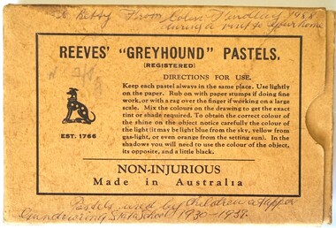
Functional object - Reeves' "Greyhound" Pastels
This box of pastels was donated to the Wodonga & District Historical Society by Betty L. Barberis (nee Barton), a prominent artist. They were given to her by Mr Colin Findlay, the teacher at Upper Gundowring Primary School from 1930 to 1939. His students at that school and many others used these pastels each day. Reeves’ “Greyhound” business was originally established by William Reeves who opened his first shop near St Paul’s Cathedral in London, England in 1766. The greyhound crest was later adopted as their emblem, taken from the coat-of-arms of the extinct Ryves family of Dorset. It consisted of a black-seated greyhound spotted with gold. After William’s death, the business was carried out by his brother, in partnership with various businessmen. They sold a wide range of art supplies in England and their trade extended to supplying drawing instruments and stationery products to the East India Company in the early 1800s. In the 1920s the Greyhound Colour Works at Enfield became known especially for its famous Greyhound pastels. Reeves Greyhound products were also being made in Melbourne, Australia. They were marketed widely through schools in all States from the 1920s onwards. Reeves continues to be a huge brand both in the United Kingdom and internationally, placed in over 70 countries worldwide including America, France, Germany, Italy, Japan, South Africa and Australia.These pastels are significant because they were widely used in Victorian Schools and were donated to our Collection by a prominent local artist.A cardboard box with a corrugated cardboard to store 12 pastels. The pastels are held in a cardboard tray insert.REEVES' 'GREYHOUND" PASTELS (REGISTERED) Directions for use Non-INJURIOUS Made in Australia On each pastel: REEVES GREYHOUND reeves greyhound pastels, primary school art supplies, education 1930s, upper gundowring primary school, betty l. barberis -
 Eltham District Historical Society Inc
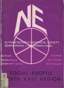
Book, North Eastern Suburbs Family and Community Services Regional Consultative Council, Social Profile North East Region, January 1985
Comprehensive statistical overview of Melbourne's north east region. The profile draws on census data for 1976 and 1981. Local Government summaries for the local government areas of Diamond Valley, Eltham, Heidelberg, Northcote, Preston and Whittlesea. Sections include demographic profiles (including family type and migrant populations), workforce, housing, education, support services, children's services, transport, recreation and leisure facilities, local government authorities, and local government area profile summaries.non-fictionComprehensive statistical overview of Melbourne's north east region. The profile draws on census data for 1976 and 1981. Local Government summaries for the local government areas of Diamond Valley, Eltham, Heidelberg, Northcote, Preston and Whittlesea. Sections include demographic profiles (including family type and migrant populations), workforce, housing, education, support services, children's services, transport, recreation and leisure facilities, local government authorities, and local government area profile summaries.population, social profile, social service, demographics -
 Wodonga & District Historical Society Inc
Domestic object - Small Butter Churn, E. Cherry & Sons, c1880 - 1920
North east Victoria was a major dairy producing region in the late nineteenth century. The Wodonga Butter Factory Ltd was established in 1892. Many families living in the town or on farms also owned their own cow for family needs and produced their milk and butter. This churn is representative of the equipment they used to process their own dairy products at home. This churn was made by E. Cherry & Sons which was established in Gisborne, Victoria in 1858. Edward Cherry (1830-1910) arrived in Australia from Hertfordshire, England, in 1855. The business manufactured churns and in 1875 opened a larger factory. On his death, the business was taken over by his son and continued to operate until the 1970s.This item has strong links to the history of Wodonga and north east Victoria. It has interpretative potential in the areas of local agricultural history, and the social history of food and farming.A wooden butter churn with metal turning handle and removable lid. The wooden paddle inside is attached to the turning handle which rotates to churn the butter. The model number is T1. It was probably made by E Cherry & Sons of Gisborne although the brand is blurred.On one side in black: "T 1"butter churns, dairying industry, domestic appliances, e. cherry churns -
 Ringwood and District Historical Society
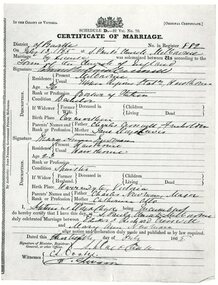
Document, An excerpt of the account book from Charles Newman 1860-1893, including marriage certificate of Mary Ann Newman, daughter of Charles, to Edward Richard Crosswell
An excerpt of the account book from Charles Newman 1860-1893, including marriage certificate of Mary Ann Newman, daughter of Charles, to Edward Richard Crosswell on 13 July 1865 at St Paul’s Church, Melbourne. Major Charles Newman (1795-1866) had one of the first pastoral holdings east of Melbourne in the 1830s. It was located around the confluence of the Yarra River and the Mullum Mullum (or Deep) Creek. The family built the historic, and heritage-listed, Pontville Homestead, constructed in the 1840s and still there today. Caroline Madden, who married Nicholas Madden, one--time owner of the Coach & Horses Hotel, was the daughter of Edward Crosswell. -
 Warrnambool and District Historical Society Inc.
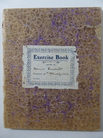
Book, Exercise book Winnie Goodall, Early 20th century
This exercise book has been used by Winnifred (Winnie) Goodall in 1916 when she was a pupil at the Warrnambool Technical School. The material in the book mostly consists of letter-writing practice for business purposes. The Goodalls were pioneer settlers in the Warrnambool district with William and Ellen Goodall arriving in the area in the late 1840s. Eventually they had a property named Wanstead on the Allansford Road in East Warrnambool. One son, William, was an early manager of the Framlingham Aboriginal Settlement. Another son, Thomas, was a Warrnambool law clerk and Winnie, (born 1901 to mother Leah), was his granddaughter. The Warrnambool Technical School was established in 1913.This exercise book is of interest as an example of school work completed by a Warrnambool Technical School student in 1916. It is also of interest because it belonged to Winnie Goodall, a member of an important pioneering family in the Warrnambool district. This is a school exercise book with a cardboard cover and 17 double pages. The cover has a mottled pattern of brown and mauve and the pages have been attached by metal staples but the staples have been removed. The pages have blue ruled lines with handwritten material in blue and black ink. Some of the pages have red hand-drawn lines. The cover is slightly torn. On the first page two cartoon sketches from a newspaper have been pasted in. The front cover has a printed label in blue and white colouring pasted on, with handwritten information on the label. There is a has a circular black , white and blue logo pasted on the inside front cover.‘Exercise Book Written by Winnie Goodall, Commenced 9th February 1916’. Inside cover Logo: Sons of Temperance Warrnambool Division Instituted March 11 1870 Be Firm and Faithful Love Purity Fidelity winnifred goodall, warrnambool technical school, sons of temperance warrnambool -
 Bacchus Marsh & District Historical Society
Map, Plan of the property of Messers Atkins and Clarke to be sold at the Mansion, Bacchus Marsh 19th April 1856. Copy 1
This plan of land allotments for sale indicates the property once owned by the Bacchus family in and around the township area of Bacchus Marsh. The Bacchus family sold their property in Bacchus Marsh to John Atkins and Robert Nalder Clarke in March 1851. Atkins and Clarke kept the property for a number of years until April 1856 when these allotments were put up for sale.This plan is almost identical to another copy held by the Bacchus Marsh and District Historical Society, VC Record 452, BMDHS collection). This plan, VC Record 707 Copy 1, contains a little more detail overall than VC Record 452 Copy 2, such as who did the survey work for the plan (R.C. Bagot) and who the selling agents were, (W.M. Tennent), and on the right side of the plan near the Lerderderg River is indicated the general area for a second parcel of land from this sale which is to be sold. There is also a compass illustration indicating north and south compass points.This is a very early land sales plan for the township of Bacchus Marsh and it therefore provides some clues as to how the early urban development of the township took place. Upon seeing the map in 1911 Bacchus Marsh Express newspaper editor Christopher Crisp wrote "The sale appears to have created the present township, which had a nucleus in earlier times further east", Express, 30 September, 1911, page 3.A single page paper plan showing allotments of land for sale. The subdivided land shown was owned by John Atkins and Robert Nalder Clarke, but previously owned by the Bacchus Family and was in and around their Manor House (Mansion) property in Bacchus Marsh.There are 5 portions of land further divided into numerous small portions. The land for sale is bounded by the present day streets of Main Street, Young Street, McFarland Street, Morton Streets, Crook Street, and part of the eastern section extends to the Lerderderg River. Scale: 8 chains to 1 inch The plan is pasted into a bound volume containing 76 maps or plans in total. BMDHS Loc: AR/B12/S4 Bacchus Marsh Township and Nearby Districts Maps Volume In-house Digital copies: BMDHS, Computer Network: Maps\Bacchus Marsh Township and Nearby Districts Maps VolumeHeading: Plan of the first portion of land. The property of Messers Atkins and Clarke situate at Bacchus Marsh. To be sold by W.M. Tennent & Co. at the Mansion on the Ground on Saturday the 19th April 1856. Below heading: Jas Ferguson, Lithographer On upper right side: Subdivided by R.C. Bagot London and Liverpool Chambers, Melbourne. 'Thos Taubman'. Post Office Stamp: BACCHUS MARSH VICTORIA MY 6, 63bacchus marsh victoria maps, bacchus family, land sales, manor house bacchus marsh -
Glen Eira Historical Society
Article - St Peter's Catholic Church, Bentleigh East
Included In The File is A Newspaper Clipping From The Age Newspaper, Dated Sat 09/11/1974 On The Opening Written By Stuart Sayers. The Article Mentions A Brief History Of The Church & School Beginnings & The Opening Ceremony. There Are Two Copies Of The Living Harvest (One Without The Cover), The Book Gives A Detailed History Of St Peter's Catholic Church, Bentleigh East Written By W.T. Dobson And Published in 1974. From The First White Settlers, The Irish Exodus, And The Irish Catholic families, The School House And The History Of The Parish & Clergy Up To 1974.st peter's catholic church, niall patrick rev, emerald hill, bentleigh east, dobson w. t., yarra, moorabbin, heriot m. b., elsternwick, north road, quinn fred, bentleigh, centre road, kennedy james joseph, melbourne south, bignell road, kennedy market garden, oakleigh, st peter's parish, st james parish, the living harvest, catholic church, hibernian society, bavarian brass band, st peter's primary school, st james regional college, brighton catholic school, brighton – st kilda mission, niall patrick william fr, dendy henry, guiney john mr, king richard, king john, keys george, o’ shanassy john, keys robert, were jonathan b., o’ connell john fr, glass hugh mr, o’ farrell peter, brady peter, kennedy james, boland michael, mccormick francis, orrong road, little brighton, oakleigh, port phillip bay, east boundary road, north road, ormond, old dandenong road, mordialloc creek, moorabbin, springvale, no good damper road, kingstown, keysborough, bignell road, south road, heatherton, big brighton, gardenvale, elsternwick, brady road, jasper road, chesterville road, cochrane road, mcguinness road, h.a.c.b.s., school house, st patrick's church, brighton parish, denominational school, little brighton school, moorabbin catholic school, temporary chapel, st james regional college, sister of mercy, lanigans ball, east brighton public hall company ltd, east bentleigh hall, messrs. robert dunn & son, bavarian brass band, st joan of arc parish, east bentleigh parish, the sisters of our lady of sacred heart, the anchor club, mccormick cornelius, cochrane james, cochrane david, mcguinness margaret, cormick john, cahill james, quinn frederick, prendegast john patrick, naughton dennis, leary william, charlston john, carey matthew fr, gibbons patrick, kennedy joseph james, o’ sullivan tim fr, mckenna fred fr, casey william fr, browne joseph fr, crawford mal fr, hanrahan mr, gillon rose miss, sampson kate mrs, horan miss, coakley daniel fr, dillon kevin fr, whitehouse ray fr, mannix daniel dr, dobson william mr, gahan patrick, hallinan thomas, delaney john, fitzgerald patrick, st peter's catholic church -
 Warrnambool and District Historical Society Inc.
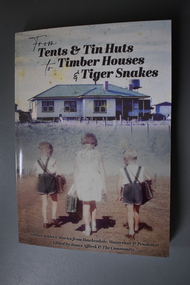
Book, From tents & tin huts to timber houses & tiger snakes: Soldier Settler stories from Hawkesdale, Macarthur & Penshurst, April 2021
Soldier settler family stories from the Hawkesdale, Macarthur and Penshurst areas.A4 soft bound book with photograph of timber house in country location with post and wire fence and three children walking towards the house; a girl in light-coloured dress carrying a school case is in the middle with a boy in crossover top shorts with school bag over their right shoulders on either side of her. Text is black.non-fictionSoldier settler family stories from the Hawkesdale, Macarthur and Penshurst areas.military history, soldier settlement wwii, hawkesdale, macarthur, penshurst, eugene von guerard, robert dowling, first australians -
Lakes Entrance Historical Society
Album, M Fish, East Gippsland Settlement
Many copied from publications of Bairnsdale, Metung, Lakes Entrance, Lake Tyers, including Whiter Family and Whiters Camp Park, Gill Roberts family and "Firefly" S.S. Dargo, P.S. Tanjil, Captain James Bull, Scone Cottage, Bancroft Bay, W H Glover Scarborough Hotel, J.C. Dahlsen, Kitty Johnson, Nelly Blair, Red folder containing 85 images of East Gippsland settlements and activities East Gippsland Victoriawaterways, township, ships and shipping, genealogy