Showing 2828 items
matching government roads
-
 Eltham District Historical Society Inc
Scrapbook Album, The Colour and Texture of Eltham, 1997, 1997
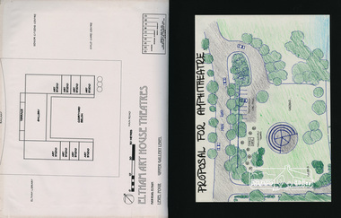
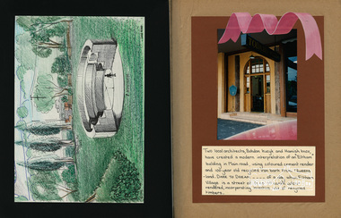
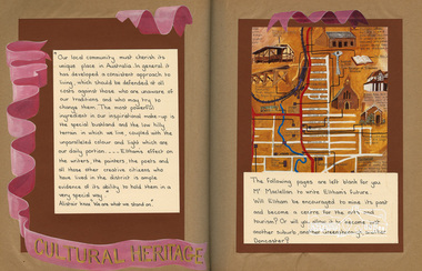
Put together by a member of the Eltham Community Action Group in participation with various artists, writers, local business people and other local citizens and sent to Minister Maclellan, Planning Minister in the Kennet Government in protest of proposed plans to sell the former Eltham Shire Office site at 895 Main Road Eltham in order to develop a Shell Service Station and Hungry Jacks fast food outlet. The purpose was to express what is unique about the character of Eltham, why people live and work there and why such a development would be out of character and inappropriate for the Eltham Gateway along with alternative development proposals. This protest was the catalyst for the formation of the Eltham Community Action Group.Scrapbook album approx 40 x 30 x 4 cm, black hardcovers and 36 double page openings, numerous blank pages.alan marshall, alistair knox park, alistair knox, alternative proposals, ampitheatre, artists, betty langley, bohdan kucyk, bootmakers cottage, bridge street, cultural heritage map, david armfield, diamond creek, diamnond valley news, eltham art house theatres, eltham community action group, eltham library, eltham traders, eltham, flavour of eltham, george stebbing, gordon ford, hamish knox, helen lucas, hungry jacks, janet r boddy, jarrold cottage, jarrold family, john pizzey, jon weaving, lena skipper, letters, local business register, 895 main road, main road, eltham shire office, matcham skipper, ming mackay, minister maclellan, montsalvat, mudbrick, newspaper clippings, peter dougherty, peter glass, pioneers and painters, railway line, shell service station, shelltham, protests, shillinglaw cottage, shire of eltham, nillumbik shire, st margaret's anglican church, todaro, trestle bridge, wingrove cottage, charles symons wingrove -
 Eltham District Historical Society Inc
Scrapbook Album, The Colour and Texture of Eltham, 1997, 1997
Put together by a member of the Eltham Community Action Group in participation with various artists, writers, local business people and other local citizens and sent to Minister Maclellan, Planning Minister in the Kennet Government in protest of proposed plans to sell the former Eltham Shire Office site at 895 Main Road Eltham in order to develop a Shell Service Station and Hungry Jacks fast food outlet. The purpose was to express what is unique about the character of Eltham, why people live and work there and why such a development would be out of character and inappropriate for the Eltham Gateway along with alternative development proposals. This protest was the catalyst for the formation of the Eltham Community Action Group.Scrapbook album approx 40 x 30 x 4 cm, black hardcovers and 36 double page openings, numerous blank pages.alan marshall, alistair knox park, alistair knox, alternative proposals, ampitheatre, artists, betty langley, bohdan kucyk, bootmakers cottage, bridge street, cultural heritage map, david armfield, diamond creek, diamnond valley news, eltham art house theatres, eltham community action group, eltham library, eltham traders, eltham, flavour of eltham, george stebbing, gordon ford, hamish knox, helen lucas, hungry jacks, janet r boddy, jarrold cottage, jarrold family, john pizzey, jon weaving, lena skipper, letters, local business register, 895 main road, main road, eltham shire office, matcham skipper, ming mackay, minister maclellan, montsalvat, mudbrick, newspaper clippings, peter dougherty, peter glass, pioneers and painters, railway line, shell service station, shelltham, protests, shillinglaw cottage, shire of eltham, nillumbik shire, st margaret's anglican church, todaro, trestle bridge, wingrove cottage, charles symons wingrove -
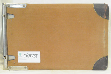
 Orbost & District Historical Society
programs, 1961
The Snowy River Shire was a local government area in the Australian Alps region of New South Wales, Australia from 1939 until May 2016. It was named after the Snowy River that runs through it. Prior to 1936, it had been named as Dalgety Shire since establishment in 1906. This opening of the Monaro - Gippsland Road took place on 4th May 1961. There had long been a movement in Monaro for the construction of a road to connect Monaro and Gippsland, via Inglebyra and Black Mountain. The only track was for stock, made by pioneers many years ago, and it was very circuitous. It was stated at a meeting at Dalgety that the road would open up large areas for settlement for grazing, and for timber suitable for bridgé building. The road would assist stock deal ing between Monaro and Gippsland. It would also considerably shorten the distance from Victoria for tourists visiting Canberra and Kosciusko. A committee was formed to put the proposal before the Dalgety Shire Council in the 1930s.This item is a useful research tool.Four copies of a road opening program. It has black print on white. There are black / white photographs, historical details and details of the official opening.program monaro-road snowy-river-shire -
 Orbost & District Historical Society
program, 1936
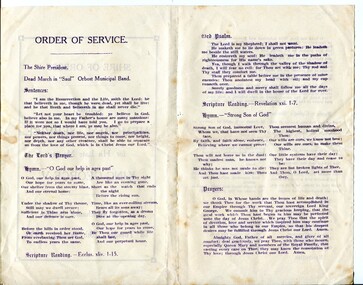
This service was held on January 28, 1936 at the Mechanics' Institute, Orbost. Born in 1865, George V was the second eldest son of Edward VII and Alexandra 1865. He first visited Australia with his elder brother Prince Albert as midshipmen aboard the HMS Bacchante in 1880. He was King of the United Kingdom and the British Dominions, and Emperor of India, from 6 May 1910 until his death in 1936. The Shire of Orbost was a local government area about 380 kilometres east of Melbourne. The shire covered an area of 9,347 square kilometres and existed from 1892 until 1994. Originally, Orbost was part of the Bairnsdale Road District which was created on 30 April 1867. Splitting away as part of the Shire of Tambo in 1882, Orbost was first incorporated as a shire in its own right as the Shire of Croajingolong on 30 May 1892. It received its present name on 17 February 1893. On 3 January 1913 part of its western riding was annexed to Tambo as its Cunninghame Riding. On 2 December 1994, the Shire was abolished, and merged with City and Shire of Bairnsdale, Shire of Tambo, most of the Shire of Omeo and the Boole Boole Peninsula from Shire of Rosedale into the Shire of East Gippsland.This item reflects the significance of monarchy for Australia and the constitutional history of Australia.The item reflects the interest in the royal family to Australians at this time as well as the general feeling of respect and admiration felt by the rural communities towards the British Royal Family..A folding single sheet, white paper program with a dark purple print. It is a program for the Orbost Shire Council memorial service for the death of King George V. On the front is "Shire of Orbost Memorial Service for his late Majesty King George V". Details of the time and venue are below. This print is inside a rectangular border. On the back of the program are the words of the national anthem, Kipling's "Recessional" and a prayer. Inside is the order of the service.royalty george-v-death-memorial orbost-shire-council -
 Orbost & District Historical Society
menu, 1912
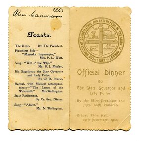
This item is an invitation to a dinner given by the Shire President and Mrs Hugh Cameron for the State Governor and Lady Fuller to be held in the Orbost Shire Hall on November 19, 1912. The governor and his wife left Melbourne on November 14 on a visit to East Gippsland. Hugh Cameron (1850-1921) was on the Orbost Shire council from 1892-1915. (more info. in O.D.H.S. newsletter -Tambo Shire) The Shire of Orbost was a local government area about 380 kilometres east of Melbourne, the state capital of Victoria, Australia. The shire covered an area of 9,347 square kilometres (3,608.9 sq mi), and existed from 1892 until 1994. Originally, Orbost was part of the Bairnsdale Road District which was created on 30 April 1867. Splitting away as part of the Shire of Tambo in 1882, Orbost was first incorporated as a shire in its own right as the Shire of Croajingolong on 30 May 1892. It received its present name on 17 February 1893. On 3 January 1913 part of its western riding was annexed to Tambo as its Cunninghame Riding. On 2 December 1994, the Shire was abolished, and merged with City and Shire of Bairnsdale, Shire of Tambo, most of Shire of Omeo and the Boole Boole Peninsula from Shire of Rosedale into the Shire of East Gippsland. This item is associated with Orbost Shire Council which no longer exists. It is also associated with Hugh Cameron.A small menu on a cream folded card with blue print. On the front is stamped a large blue logo of the Shire of Orbost. The text is "Official Dinner". On the back is a list of toasts and inside is the menu.On back - handwritten - "Alex Cameron"orbost-shire-council cameron-hugh -
 Orbost & District Historical Society
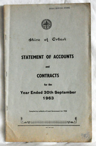
statement of accounts, Shire of Orbost Statement of Accounts, 1963
This document was made by the Shire of Orbost, local government. The Shire of Orbost was a local government area about 380 kilometres (236 mi) east of Melbourne, the state capital of Victoria, Australia. The shire covered an area of 9,347 square kilometres (3,608.9 sq mi), and existed from 1892 until 1994. Originally, Orbost was part of the Bairnsdale Road District which was created on 30 April 1867. Splitting away as part of the Shire of Tambo in 1882, Orbost was first incorporated as a shire in its own right as the Shire of Croajingolong on 30 May 1892. It received its present name on 17 February 1893. On 3 January 1913 part of its western riding was annexed to Tambo as its Cunninghame Riding. On 2 December 1994, the Shire was abolished, and merged with City and Shire of Bairnsdale, Shire of Tambo, most of Shire of Omeo and the Boole Boole Peninsula from Shire of Rosedale into the Shire of East Gippsland. Local governments play an important role in the lives of citizens in Australia. Local government authorities exist to provide services and amenities to local communities, and are also responsible for regulating and providing services for land and property in their district. This item is representative of a time when Orbost had its own Shire Council. A document with a light blue cover, black print. It is a "statement of accounts for the Shire of Orbost for the year ended 30th September, 1963".document-statement-of-accounts orbost-shire -
 Ringwood and District Historical Society
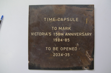
Time Capsule Notice, Uninstalled plaque - one of an unknown number of time capsule plaques produced and circulated by Victorian State Government to mark the state's 150th Anniversary, 1984/85, 1984 - 1985
Installed 1984 - 1985Time Capsule Notice. Bronze, engraved with white paint infill. Inscribed as follows: 'Time Capsule/ to mark/ Victoria's 150th Anniversary/ 1984 - 85/ to be opened/ 2034 - 35.Time Capsule/ to mark/ Victoria's 150th Anniversary/ 1984 - 85/ to be opened/ 2034 - 35 -
 Ringwood and District Historical Society
Invitation card, Ringwood Historical Research Group AGM Invitation card 1967, 26-Jul-67
Invitation from President of RHRG, E.V. Pullin & secretary B.M. Jamieson to Mr. K. Ward, Chamber of Commerce, to be present at the 1967 AGM. Speaker was Mr. H.S. McComb on "Development of Region East from Melbourne 1837-1860 According to Government Surveys".Buff coloured card marked Ringwood Historical Research Group inviting person to annual meeting on Wed 26-Jul-1967 in Lower Town Hall, Ringwood, at 8pm +Additional Keywords: Pullin, E.V. / Jamieson, B.M. / Ward, K. / McComb, H.S. -
Ringwood and District Historical Society
Map, Government Printer, Melbourne, Ringwood Zone Ordinance Survey Map, 1935
Ordinance survey map glued to cheesecloth, of Ringwood zone - Commonwealth topographical map dated 1.8.35, scale 1:63,360. Information correct up to June 1922. "Ringwood 81" printed on the reverse side.; Envelope and note from donor of item, with return letter of appreciation from Ringwood & District Historical Society dated 20-May-2005. +Additional Keywords: Reid, Don -
Ringwood and District Historical Society
Shield, Awaiting Cataloguing: Commemorating Australian Government's provision of funds to Parkwood Secondary College, 2008
Commemorating Australian Government's provision of funds to Parkwood Secondary College"Australian Government - The Australian Government provided the funds to Parkwood Secondary College to enable the construction of these Multi Purpose courts under the Investing In Our Schools Programme 2008" -
Ringwood and District Historical Society
Envelope, Packet: Government Gazette photostats incl Toll charges 1864, Ringwood Cemetery 1871, Berwick items
... Road Ringwood North melbourne Government Gazette photostats (10 ...Government Gazette photostats (10 pages); Toll charges 1864; Berwick Road District 1862; Berwick Shire 1864; Berwick Shire added to 1871; Ringwood Cemetery 1871; Lillydale Shire 1872 -
 Ringwood and District Historical Society
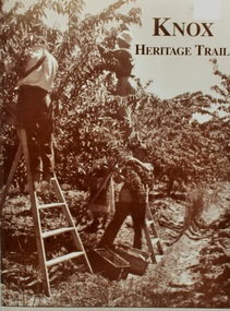
Book, Knox Heritage Trail Book. By Glen Turnbull, Knox Historical Society 2002, 2002
A Federation Fund Project 1901-2001 Commonwealth Government Initiative. Contents- brief history of the district, Knox Heritage Trust Sign Locations. Shire of Ferntree Gully Council 1901. History of Federal Electorates. History of the Knox Historical Society. Many photographs. 60 pagesBook 'Knox Heritage Trail' 60 pages. Front page shows three fruit pickers with ladders and two fruit boxes.Back page has photo of tree ferns. in sepia colour. +Additional Keywords: Turnbull, Glen -
Ringwood and District Historical Society
Envelope, Jean Gordon Government Printer - Melbourne, Ringwood Primary School: Documents re Proposed school rooms, Canteen and Library plans, electrical plans. 1969-1973, 1969-1973
School PlansRingwood Primary School Documents:; 1969 Proposed school rooms - Plans.; No Date - Canteen Plans.; 1973 Library - Plans.; No Date - Electrical Plans. +Additional Keywords: Gordon, Jean -
Ringwood and District Historical Society
Envelope, Local Government
List of Mayors and Borough City Engineers (hand written notes); Lists compiled for City of Ringwood History -
 Ringwood and District Historical Society
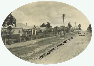
Photograph, Warrandyte Rd. looking north past Mullum Rd(undated)
... and Financial Agent, District Government Valuer, Ringwood" Dirt Road ...Dirt Road with houses. Text on photo states "Warrandyte Road" and "Mullum Rd To Estate"Typed below photograph, "Warrandyte Rd. looking north past Mullum Rd." On back of Oval copy of photograph (original?), is stamped the name "J.B. McAlpin, Estate and Financial Agent, District Government Valuer, Ringwood" -
 Ringwood and District Historical Society
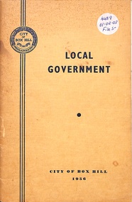
Booklet, Local Government - City of Box Hill 1956
Yellow soft-covered booklet collated and written for the Council of the City of Box Hill - 3rd Edition 1956. Summarised history with black and white photographs. -
 Orbost & District Historical Society
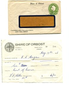
envelope and receipt, Snowy River Mail as "Mail" Print, May 17 1956
This receipt was issued to R. C. Morgan of Orbost. on May 17, 1956. It was for rent of reserve for six shillings. It was issued by the Orbost Shire Council. The Shire of Orbost was a local government area about 380 kilometres east of Melbourne, the state capital of Victoria, Australia. The shire covered an area of 9,347 square kilometres and existed from 1892 until 1994. Originally, Orbost was part of the Bairnsdale Road District which was created on 30 April 1867. Splitting away as part of the Shire of Tambo in 1882, Orbost was first incorporated as a shire in its own right as the Shire of Croajingolong on 30 May 1892. It received its present name on 17 February 1893. On 3 January 1913 part of its western riding was annexed to Tambo as its Cunninghame Riding. Local governments play an important role in the lives of citizens in Australia. Local government authorities exist to provide services and amenities to local communities, and are also responsible for regulating and providing services for land and property in their district. This item is representative of a time when Orbost had its own Shire Council. A widow - faced envelope with a green threepence stamp top right corner. At the top is "Shire of Orbost". Bottom right is "If not claimed within 7 Days please return to SHIRE HALL, ORBOST".There is a receipt to R.C. Morgan for 6/- being for the "rent of reserve" and signed by L.A. Walker. It has the Orbost Shire logo in the top left corner.orbost-shire-council morgan-r.c. -
 Ringwood and District Historical Society
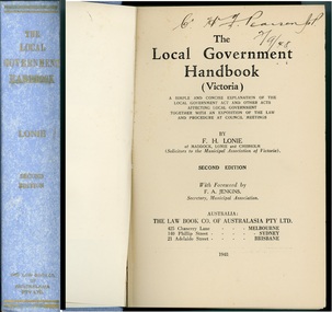
Book, Deaton & Spencer Pty. Ltd, The Local Government Handbook (Victoria) - Second Edition 1948, 1948
Blue hard cover reference book by F.H. Lonie of Maddock, Lonie and Chisholm, solicitors to the Municipal Association of Victoria. A concise explanation of the Local Government Act and procedure at Council meetings.Dedication (by Leigh Blackburn) - To my son Peter James Blackburn 1945-1991 who shared with me my association with the Stokes company. Foreword by F.A. Jenkins, Secretary, Municipal Association. -
 Ringwood and District Historical Society
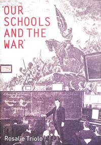
Book, Australian Scholarly Publishing Pty Ltd, Our Schools and the War - Rosalie Triolo, 2012
Rosalie Triolo presented Our Schools and the War as Ringwood and District Historical Society guest speaker - June, 2022. Dr Rosalie Triolo is the History Method lecturer in the Faculty of Education at Monash University and is active as a writer and presenter in state and national History Education communities. She taught for 13 years in country and metropolitan Victorian government secondary schools, and has been involved for 30 years with the History Teachers’ Association of Victoria. She p[resents regularly to academic and general audiences on different aspects of the Great War and Australian education, and has led battlefield tours for History teachers as well as Australian History fellowships for student-teachers. The doctorate on which this book is based was awarded a Monash University Mollie Holman medal.Soft cover book detailing how The Great War profoundly touched the lives of Australian teachers, school children, and local communities.Handwritten inscription - For RDHS, Congratulations on all you are doing so well. Sincerely, Rosalie Triolo, June 2022. -
 Ringwood and District Historical Society
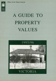
Book - Collection, Valuer General of Victoria, Guide to Property values in Victoria 1988-2006 (16 volumes), 1988-2004
part of the Richard Carter CollectionCollection of 16 books from the Office of the Valuer general with data and analysis of property values in Victoria by City and by Shire. With maps of local government. 1988-1994 A4 in size reducing to a slightly smaller size 1996-2006. Originals not kept - only scanned pages of City of Ringwood and Maroondah City Council PDFed. Refer to Victorian Government websites (www.land.vic.gov.au, www.consumer.vic.gov.au and others for Excel downloads and further details. -
 Ringwood and District Historical Society
Photograph, Overlooking Ringwood from Loughnans Hill showing the antimony mine and brick works c.1914
Two postcards, same view but different reverse sides. One was made by "Empire" with a 1d postage (see description below); the other with "JB McAlpin, Estate and Financial Agent, District Government Valuer, Ringwood". A letter on one of the postcards is dated 1914 and is addressed to "Mrs. F. Palmer, c/- Mrs. E. F. Tregaskis, White Horse Road, Ringwood, via Melbourne". The letter is to her mother and the daughter's name is "Eveline". The following is written on the back of one of the enlargements, "View of Ringwood East taken from Loughnans Hill showing the antimony mine and brick works. Houses across centre are in Warrandyte Road. -
 Ringwood and District Historical Society
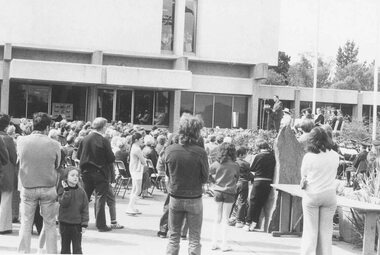
Photograph, Minister for Local Government speaking at 'Back to' Ringwood Civic Centre, 1974
Written on back of photograph, 'Minister for Local Government speaking at 'Back to' Civic Centre, 19/10/74'. -
 Orbost & District Historical Society
ledger, 1950's ; 1960's
... . The Country Roads Board was the government authority.... The Country Roads Board was the government authority ...This ledger was used by the Shire of Orbost to record transactions with the Country Roads board in 1950's and 1960's. The item was donated to Orbost & District Historical society from P.R.O.V. as a Place of Deposit (POD) item for safe keeping by a local history group or museum. The shire covered an area of 9,347 square kilometres and existed from 1892 until 1994 when it became part of the East Gippsland Shire Council. Orbost was at first included in the Bairnsdale Shire from 1882 and was later part of the Tambo Shire. Because of travelling distances the Croajingalong Shire was created in 1892 (name changed to Orbost Shire 17.2.1893 with James Cameron as the first Shire President. In 1994 it amalgamated to become part of East Gippsland Shire Council. The Country Roads Board was the government authority for the construction and maintenance of main roads in Victoria between 1913 and 1983. It was succeeded by the Road Construction authority on 1 July 1983 and later merged with the Road Traffic Authority on July 1 1989 to form the Roads Corporation. James Cameron, an Orbost farming pioneer and Member of the Legislative Assembly, fathered the Country Roads Board. This item is a hand-written record of accounts of the Orbost Shire local Government. It pre-dates computer records,The Shire of Orbost Council no longer exists having been absorbed into th East Gippsland Shire council.A heavy brown coloured ledger with steel bindings. Covers are probably wooden. It contains hand-written records of transactions the Country Roads Board. -
 Orbost & District Historical Society
ledger, late 1950's - 1970's
... of East Gippsland Shire Council. The Country Roads Board... of East Gippsland Shire Council. The Country Roads Board ...This ledger was used by the Shire of Orbost in the late 1950's - 1970's.The item was donated to Orbost & District Historical society from P.R.O.V. as a Place of Deposit (POD) item for safe keeping by a local history group or museum. The shire covered an area of 9,347 square kilometres and existed from 1892 until 1994 when it became part of the East Gippsland Shire Council. Orbost was at first included in the Bairnsdale Shire from 1882 and was later part of the Tambo Shire. Because of travelling distances the Croajingalong Shire was created in 1892 (name changed to Orbost Shire 17.2.1893 with James Cameron as the first Shire President. In 1994 it amalgamated to become part of East Gippsland Shire Council. The Country Roads Board was the government authority for the construction and maintenance of main roads in Victoria between 1913 and 1983. It was succeeded by the Road Construction authority on 1 July 1983 and later merged with the Road Traffic Authority on July 1 1989 to form the Roads Corporation. James Cameron, an Orbost farming pioneer and Member of the Legislative Assembly, fathered the Country Roads Board This item is a hand-written record of Orbost Shire Council accounts. It pre- dates computer records. The Shire of Orbost local council no longer exists having been absorbed by the East Gippsland Shire Council.A black ledger with wooden covers. It contains hand-written records of transactions between Orbost Shire Council and the Country Roads Board.bottom left corner - Orbost in black on a white East Gippsland Shire logoledger accounts shire-of-orbost country-roads-board -
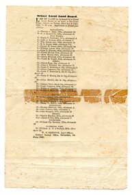 Orbost & District Historical Society
programe, 1888
Local land boards were community based "tribunals" consisting of a chairman appointed by the the state government and two(?) local members who were there or their knowledge of local land management practices. These boards were establishe in the mid-late 19th century and generally dealt with disputes about fencing, water rights, general land enquiries and the opening or closing of local roads.This document is a record of local land issues in the late 19th century. A sheet of paper, held together with sticky tape, stating the names of cases to be read by court regarding land. document land-use land-board gregson -
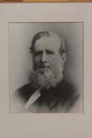 Learmonth and District Historical Society Inc.
Photo - Baird,J.(1863), Richards & Co.Ballarat, James Baird,"circa 1863", "circa 1863"
Councilor James Baird was elected as a member of the first Ballarat Shire Council in 1863 becoming the first Shire President for 1863-64,and was on council until 1865.He was then re-elected to council in1868 until 1887.He then served three more terms as President 1874-75 ,1875-76, and 1879-80.This original photo is of the first President of the newly formed Ballarat Shire. On 16th November (monday)1863, it was declared that the Ballarat Road Board District to be a Shire known as the Shire of Ballarat.This document was signed and sealed by Colonial Governor Charles H.Darling. The declaration was published in The Government Gazette on tuesday 24th November 1863. This rectangular black and white photo of James Baird,(circa 1863),is in a white mount with a wide walnut frame.The inner part of the frame has three parts, a narrow decorative gold painted trim,a narrow black trim,then a wider gold "frame"which has carved edging on outer and in each corner is featured carved "leaf " decorations. Richards & Co. Ballarat.james baird, ballarat shire, first shire president 1863, ballarat road board district, colonial governor charles h darling, 16th november 1863 -
 Cheese World Museum
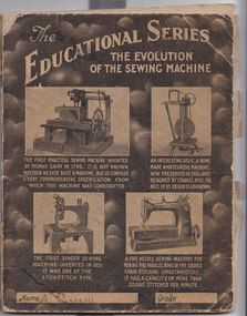
Exercise Book, A Carroll Exercise Book
This exercise book was donated by Donna Daly, who found it among her parents belongings. Her parents were Josie and Tich Kelly and she was unsure of the connection with A Carroll.This document is significant as it indicates records kept on-farm by some farmers. It records prices received for milk, calves, pigs and the amount of the government subsidy during this period which covers the time of World War II. It provides an interesting comparison with the Taylor milk passbook from 1895 and associated milk slips which are also held by Warrnambool Cheese & Butter Factory.Fawn coloured exercise book with pictures of old sewing machines on the front cover and Arithmetic tables on the back in blue printing. The contents include farm records from 1935 to 1945 documenting income from dairy, calves and pigs.A Carroll (front cover) A Carroll, Mepunga West (back cover) -
 Flagstaff Hill Maritime Museum and Village
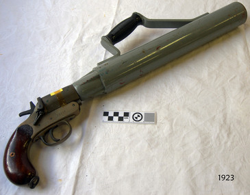
Equipment - Line throwing pistol, 1925-1945
This is a SPRA, or Schermuly’s Pistol Rocket Apparatus. The large firearm type pistol would have been used to throw a line between ships, usually in the event of saving lives. The line throwing pistol consists of a long barrel with handle attached, a pistol grip and trigger, which fires a short blank cartridge. Accessories for the pistol included: flares, 12 gauge adaptor (to shoot 12 gauge flares), a wood plunger, and boxes of faked line. The stamp on the handle, Crown over "NP" is a Birmingham Proof House mark that dates the pistol between 1904 and 1954. However Schermuly's line throwing pistol was invented in the 192s and used on British Naval Ships from 1929. The serial number '22507' is only 806 numbers later than one on sale as a British Military WWII issue SRPA '21701'. This pistol appears to be made 125-1945. The apparatus was used as a life saving device for crew and passengers on vessels in distress that were only a few hundred metres from shore, often eliminating the need to launch a boat and risk lives to go out to the vessel in dangerous conditions. It could also be used from ship to ship rescue. The pistol would launch a line from shore to the vessel. The line would be attached to the vessel, then shore crew would send out equipment, including a breeches buoy, in which the stranded people could be pulled to shore. It has saved many lives at sea. The cartridge is loaded into the breech of the pistol and the rocket is inserted into the muzzle. On pulling the trigger, the gases generated by the fired cartridge eject the rocket on its correct line of flight, and at the same time, burst through the waterproof disc and ignite the propellant mixture, which carries the rocket and line on the remainder of the flight. The rocket consists of a weldless steel case filled with propellant mixture sealed in by a waterproof disc. Fixed to the rocket case is a direction bridle, to the end of which a short length of flexible steel wire is attached, this in turn being connected to the end of the line to be thrown. A complete rocket set, or line throwing kit. would include a wood carrying case, two coils of faked line in separate compartments, three rockets and a can of six cartridges. William Schermuly (1857 – 1929) - Founder of the Schermuly business. In 1897 he invented a trough-fired, line throwing apparatus. In 1920 he and his third son, Alfred James Schermuly, invented the pistol rocket apparatus and promoted this overseas during the 1920s. The system was approved by the British Navy in 1929 through an Act of Parliament, which made it compulsory for ships over 500 tons to carry this equipment. The company, Schermuly Pistol Rocket Apparatus Ltd., grew quickly during and after World War II but business eased off during the 1970s before it eventually closed in the 1990s. Saving lives in Warrnambool – The coastline of South West Victoria is the site of over 600 shipwrecks and many lost lives; even in Warrnambool’s Lady Bay there were around 16 known shipwrecks between 1850 and 1905, with eight lives lost. Victoria’s Government responded to the need for lifesaving equipment and, in 1858, the provision of rocket and mortar apparatus was approved for the lifeboat stations. In 1859 the first Government-built lifeboat arrived at Warrnambool Harbour and a shed was soon built for it on the Tramway Jetty, followed by a rocket house in 1864 to safely store the rocket rescue equipment. In 1878 the buildings were moved to the Breakwater (constructed from 1874-1890), and in 1910 the new Lifeboat Warrnambool arrived with its ‘self-righting’ design. For almost a hundred years the lifesaving and rescue crews, mostly local volunteers, trained regularly to rehearse and maintain their rescue skills. They were summoned when needed by alarms, gunshots, ringing bells and foghorns. In July 1873 a brass bell was erected at Flagstaff Hill specifically to call the rescue crew upon news of a shipwreck. Some crew members became local heroes but all served an important role. Rocket apparatus was used as recently as the 1950s. This line-throwing pistol is part of he Rocket Launching Equipment used to perform life-saving rescue at sea from the 1920s. It is significant for its connection with local history, maritime history and marine technology. Lifesaving has been an important part of the services performed from Warrnambool's very early days, supported by State and Local Government, and based on the methods and experience of Great Britain. Hundreds of shipwrecks along the coast are evidence of the rough weather and rugged coastline. Ordinary citizens, the Harbour employees, and the volunteer boat and rescue crew, saved lives in adverse circumstances. Some were recognised as heroes, others went unrecognised. In Lady Bay, Warrnambool, there were around 16 known shipwrecks between 1850 and 1905. Many lives were saved but tragically, eight lives were lost.Pistol, line-throwing, SPRA (Schermuly's Pistol Rocket Apparatus). This line throwing pistol has a wooden pistol grip, brass trigger mechanism, and a long, wide, steel barrel with Bakelite handle attached to the top. Inscriptions are stamped onto the pistol.Stamped on handle: "5" and "[symbol of a Crown] above NP" , "22507", "[within oval] SPRA" Stamped on barrel: "L22507".gun, pistol, flagstaff hill, warrnambool, shipwrecked coast, flagstaff hill maritime museum, maritime museum, flagstaff hill maritime village, great ocean road, line throwing, line throwing pistol, spra, schermuly's pistol rocket apparatus, sea rescue, pyrotechnicks, marine technology, schermuly pistol rocket apparatus ltd., william schermuly, alfred schermuly, pistol line thrower, flagstaff hill maritime museum and village, maritime village, lady bay, warrnambool harbour, port of warrnambool, shipwreck, life-saving, lifesaving, rescue crew, rescue, rocket rescue, rocket crew, beach rescue, line rescue, rescue equipment, rocket firing equipment, rocket rescue equipment, maritime accidents, shipwreck victim, rocket equipment, rescue boat, lifeboat, volunteer lifesavers, volunteer crew, life saving rescue crew, lifesaving rescue crew, rocket apparatus, rocket rescue method, shore to ship, rocket apparatus rescue, stranded vessel, line throwing mortar, rocket rescue apparatus, line thrower, lifeboat warrnambool, rocket machine, rocket head, rocket launcher, rocket line, beach rescue set, rocket set, schermuly, line-firing pistol, line throwing gun, pistol rocket apparatus, line throwing cartridge, line-throwing rocket, firearm, life saving, lsrc