Showing 1119 items matching "land development"
-
 Melbourne Tram Museum
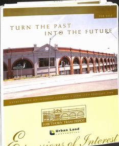
Document - Folder with papers, Urban Land corporation, "Hawthorn Tram Depot - Expressions of Interest Documentation", late 1998
White two spring clip folder with papers, titled "Hawthorn Tram Depot - Expressions of Interest Documentation", sub-titled "Turn the Past into the Future" Has a photo of Hawthorn Tram depot and an image on the front cover. Closing date 17/2/1999, prepared by the Urban Land Corporation with the assistance of VicTrack. Approx 110 pages with supplementary papers in the end covers. Contains a table of contents, checklist, EOI Process, Development Brief, Site conditions. Gives details of the heritage registration, site plans, building plans, property title and detailed room condition and use of the ground floor. Supplementary papers include the marketing brochure, letters and a detail feature and level survey by Bosco Johnson surveyors, 30-9-1998.trams, tramways, htt, hawthorn tram depot, sale of land, property -
 Melbourne Tram Museum
Document - Research Essay, Leigh J Harding, "Development of Tram Engine Houses", 1966
Research Essay, possibly the final draft, by Leigh J Harding looking at the engine houses that powered the Melbourne cable tram system from an Engineering and Architectural viewpoint. Has pencil notations to where photographs would be placed. Provides details on the background to their construction by the Melbourne Tramways Trust in the 1880s. Includes notes on the land acquisition, site plan, internal layout plan and notes on the operations and disposal. Notes on the Essendon, Bendigo and Ballarat power stations are included. The author was a Melbourne University Architecture student with this very detailed study part of his course.Yields information about the Melbourne cable tram engine houses and similar buildings.Report - 82 foolscap pages - typed and handmadetramways, tramcars, cable trams, engine house, winding houses, architects, power station -
Lakes Entrance Historical Society
Book, Morrissey D W and Morrissey E W, Lakes Entrance a Short History and Tourist Guide
A short history of lakes Entrance from early settlement, including references to forest survey, land sales, shipping, fishing industry and development of the town and tourist industry A short history of lakes Entrance from early settlement, including references to forest survey, land sales, shipping, fishing industry and development of the town and tourist industrysettlers, land settlement -
 Melbourne Tram Museum
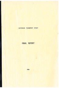
Document - Report, Ministry of Transport, Geelong Steam Preservation Society, "Victorian Transport Study - (The Lonie Report)", 1980
... to State Development - 94 pages .5 - Land transport in Victoria... to State Development - 94 pages .5 - Land transport in Victoria ...Set of reports, known as the "Victorian Transport Study - (The Lonie Report)", produced during 1980 and supplementary reports. Prepared from Robert Maclellan Minister of Transport by W. M Lonie. Documents resulted in significant change to the Victorian transport structures, especially the way freight and railway transport was handled. see http://en.wikipedia.org/wiki/Lonie_Report (accessed 25-9-2014) Documents generally perfect bound into manila coloured covers - unless noted otherwise. Comprises: .1 - Final Report - 174 pages .2 - Background to Transport Finance - white comb bound - 192 pages .3 - Summary of Submissions - fawn colour comb bound - 70 pages .4 - Background to State Development - 94 pages .5 - Land transport in Victoria - Historical background - white comb bound - 31 pages .6 - Bicycles - 19 pages .7 - Car pooling - 15 pages .8 - VicRail Financial system - 35 pages .9 - Transport of Fertilisers - 17 pages .10 - Staggered working hours - white comb bound - 16 pages .11 - Administration of Transport - 79 pages .12 - Metropolitan Roads - 60 pages .13 - Transport of Students - 24 pages .14 - Fuel for transport - unbound - stapled in top corner - photocopy of a bound document - 42 pages. This set does not comprise the full set of reports produced - see final document. .15 Autum 2016 issue of the Geelong Steam Preservation Society (Bellarine Railway) which contains an article on the Lonie Report "From Rags to Riches (Part 1). - See images 620a, 620b and 620c. The Winter issue did not have any materials on tramways.trams, tramways, transport, victoria, lonie report, railways, melbourne, tramways -
 Bacchus Marsh & District Historical Society
Map, Plan of the second portion of the property of Messers Atkins and Clarke situate at Bacchus Marsh 1856
This plan of land allotments for sale indicates part of the property once owned by the Bacchus family in and around the township area of Bacchus Marsh. The Bacchus family sold their property in Bacchus Marsh to John Aitkins and Robert Nalder Clarke in March 1851. Aitkins and Clarke kept the property for a number of years until April 1856 when these allotments were put up for sale.This is a very early land sales plan for agricultural land close to the township of Bacchus Marsh. It therefore provides some clues as to how the early urban development of the township and agricultural development of the nearby area took place. Upon seeing the map in 1911 Bacchus Marsh Express newspaper editor Christopher Crisp wrote "The sale appears to have created the present township, which had a nucleus in earlier times further east", Express, 30 September, 1911, page 3.A single page paper plan showing allotments of land for sale. The subdivided land shown was owned by John Aitkins and Robert Nalder Clarke, but previously owned by the Bacchus Family and was in and around their Manor House (Mansion) property in Bacchus Marsh. This plan shows allotments in the second portion of land to be sold which was located east of the Manor House on the eastern side of the Lerderderg River. The land for sale was made up of 15 allotments. The plan is pasted into a bound volume containing 76 maps or plans in total. BMDHS Loc: AR/B12/S4 Bacchus Marsh Township and Nearby Districts Maps Volume In-house Digital copies: BMDHS, Computer Network: Maps\Bacchus Marsh Township and Nearby Districts Maps Volumebacchus marsh victoria maps, bacchus family, land sales, manor house bacchus marsh -
Lakes Entrance Historical Society
Book, South Gippsland Development League, Land of the lyrebird, 1966
A story of early settlement in the great forest of South Gippsland including fauna hardships experienced by the early explorers and settlers and the settling and development of this once hostile and impenetrable part of Victoria. IllustratedRuth Clarkexplorers, settlers, fauna -
 Falls Creek Historical Society
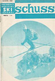
Journal - Schuss Vol. 26. No 6 August 1960
Schuss was advertised as Victoria’s Official Ski Journal It was issued monthly from 1935 to 1961 except during the war when summer issues covered two months. This continued after the war, but it averaged 10 issues annually over its 25 year life. Schuss was published by the Ski Club of Victoria which had a membership of 38 Ski Clubs and demanded to be recognised as the prime authority on skiing in the state. The other 30 ski clubs with 85% of the members disagreed and the politics of skiing became heated. These clubs formed the Federation of Victorian Ski Clubs with their own journal, Ski Horizon. With the establishment of the Victorian Ski Association, Ski-Horizon published its last issue in Nov - Dec. 1955 and the role of the official journal was fully taken over by “Schuss”. This item is significant because it contains stories, images and information documenting the development of the ski facilities at Falls Creek.The journal includes stories and events chronicling developments in Victoria and internationally. The cover features a photo of a downhill skier. Page 272 featured N.E.D.S.A notes contributed by Molly Bunyan. Page 292 carried an advertisement for the pre-selection sale for land in the Mt Beauty Estate. Ab short article on page 302 explained was now fully wired for electricity which should be connected in early August.schuss journal, skyline lodge, mount beauty estate, n.e.d.s.a. events at falls creek -
 Department of Energy, Environment and Climate Action
Altona Collection Photography and Cataloguing - November 2024
In November 2024, a small group of cheerful volunteers from the Forests Commission Retired Personnel Association (FCRPA) toiled over nine days to dust-off, photograph and record nearly 300 artifacts in DEECA's Altona Museum. It followed a similar project at the FCRPA's Beechworth Museum in February 2024. The Altona project was generously supported by DEECA / FFMVic to engage professional photographer Mark Jesser from Wodonga whose boundless energy and good humour helped to create these amazing images. Special thanks go to the FFMVic Chief Fire Officer, Chris Hardman, as well as Andrew Stanios and Kat Jensen for making it happen. FFMVic crews and the ever-patient staff from Altona took a strong interest and also helped to shift some of the heavy items like pumps and the Bedford tanker which was very welcome. The Forests Commission and its successors continuously encouraged bushfire research and innovation. In 1946 a large parcel of industrial land was purchased at North Altona as a fire cache and workshop. The Altona workshop became a hotbed of new technological thingumajigs… a marvellous blend of Aladdin’s Cave of Wonders coupled with Wallace and Gromit’s madcap contraptions… an exhilarating place where lots of gizmos were invented and tested… mostly with astounding results... but nearly always with some head-scratching frustrations… and thankfully not too much explosive mayhem. In fact, a lot of Australia’s pioneering equipment development was led by staff from Altona, often in collaboration with other State forestry and fire authorities. The CSIRO also contributed significantly. The US Forest Service, the US Bureau of Land Management and US State agencies such as the California Department of Forestry and Fire (CalFire) as well as the Canadian Forest Service faced similar challenges and proved strong and willing partners in sharing knowledge, ideas, equipment and expertise over many decades. The collection at Altona started in the 1970s by fire equipment wizard Barry (Rocky) Marsden. As obsolete equipment was returned to the Fire Protection Workshop for auction, Rocky began the process of selecting some which would be interesting to retain and display. The items at Altona represent just a small sample of the amazing story of Victoria's forestry and bushfire heritage. The largest item was undoubtedly the Bedford tanker which took two days and nearly 1000 photos which were later stitched together with photoshop. The oldest item is probably the Ericsson wall telephone from 1904. There are also many unique items, but the CSIRO incendiary machine and ping-pong incendiary machine developed at Altona probably had the most significant impact on fire management in Australia. There are plenty of gaps in the collection, but some items are in regional DEECA offices. It’s hoped to merge the FCRPA's Beechworth collection to Altona one day and rename the site to honour Rocky Marsden. There may be some additions to the Altona museum over time, but space is limited. The museum is available to visit by appointment. Peter McHugh - January 2025 forests commission victoria (fcv) -
 Department of Energy, Environment and Climate Action
Aerial Drip Torch (ADT) or "Dragon"
The Aerial Drip Torch (ADT) was an idea conceived in Canada in the 1970s by John Muraro It was developed in 1982 by the New Zealand Forest Service to become the Ashley Aphid Helitorch. Forestry Tasmania acquired one of the machines and modified it in February 1987. Also known as a dragon helitorch it consisted of a large 135-litre tank containing jellied petrol, a displacement pump, propane ignition system, burner nozzle and fire extinguisher system. It was first trialled in Victoria at Swifts Creek in 1991 and the Aerial Drip Torch (ADT) has now become standard practice.Two Aerial Drip Torches (ADTs) were built in the 1990s by the Fire Equipment Development Centre at North Altona, They were developed in conjunction with the Department of Conservation and Land Management in Western Australia. The first was trialled during the 1991/92 autumn burning season. The machine proved to be successful and a second machine was introduced in 1998 to assist with burning operations across the State. The ADTs were commonly used for regeneration burning (controlled burning of logging slash). The first ADT introduced in 1992 had a dry weight of 160kg and a capacity of 130 litres, providing about an hour of operation. Following initial use, systematic modifications were adapted including improved ignition of gel at the drop tube, installation of an air bleed valve at the pump to assist pump priming and improved mounting brackets for the CO2 bottles and propane canister attached to the machine. The second, and lightweight ADT, introduced in 1998 had a dry weight of 68kg and a capacity of 200 litres due to a smaller lightweight frame and plastic (Polyfin) tank. In operation the ADT is suspended below a helicopter via four strops attached to the vessel and a cable to the helicopter cargo hook. Gelled fuel is dispensed via a drop tube which is attached to the pump outlet of the machine, and ignited via a gas torch. Safety features built into the first ADT were: a brass melting plug designed to be activated at 200 C bursting disc designed to burst at170 Kpa should the vessel over pressurise. a pressure relief valve set to 35 Kpa ( vessel operated between 16 &34 Kpa) a low pressure sensor designed to shut down the machine should the vessel pressure drop below 15Kpa. the vessel is filled with CO2 above the gelled fuel to eliminate ignition with in the vessel. CO2 is used to expel any residue of ignited gel from the drop tube to prevent ignition when flying outside the boundaries of the burning area. See FIRE EQUIPMENT NOTE - 46 [ https://drive.google.com/file/d/1CKtcH-3rUlrtbE9dkNP27PYT2-raVVhF/view ]forests commission victoria (fcv), bushfire, bushfire aviation, planned burning -
Lakes Entrance Historical Society
Book, Town and Country Planning Board Melbourne, Gippsland Lakes Land Use Strategy Plan, 1978
Background report to the strategy plan to guide future development of the Gippsland Lakeswaterways, recreation -
Lakes Entrance Historical Society
Book, Adams John, The Tambo Shire Centenary History, 1981
A history of the Shire of Tambo, East Gippsland, Victoria, including many aspects of settlement, development, industries, transport, and the hardy people who tamed this varied and often inhospitable region.A history of the Shire of Tambo, East Gippsland, Victoria, including many aspects of settlement, development, industries, transport, and the hardy people who tamed this varied and often inhospitable region.land settlement, transport -
 Bacchus Marsh & District Historical Society
Map, Plan of the property of Messers Atkins and Clarke to be sold at the Mansion, Bacchus Marsh 19th April 1856. Copy 1
This plan of land allotments for sale indicates the property once owned by the Bacchus family in and around the township area of Bacchus Marsh. The Bacchus family sold their property in Bacchus Marsh to John Atkins and Robert Nalder Clarke in March 1851. Atkins and Clarke kept the property for a number of years until April 1856 when these allotments were put up for sale.This plan is almost identical to another copy held by the Bacchus Marsh and District Historical Society, VC Record 452, BMDHS collection). This plan, VC Record 707 Copy 1, contains a little more detail overall than VC Record 452 Copy 2, such as who did the survey work for the plan (R.C. Bagot) and who the selling agents were, (W.M. Tennent), and on the right side of the plan near the Lerderderg River is indicated the general area for a second parcel of land from this sale which is to be sold. There is also a compass illustration indicating north and south compass points.This is a very early land sales plan for the township of Bacchus Marsh and it therefore provides some clues as to how the early urban development of the township took place. Upon seeing the map in 1911 Bacchus Marsh Express newspaper editor Christopher Crisp wrote "The sale appears to have created the present township, which had a nucleus in earlier times further east", Express, 30 September, 1911, page 3.A single page paper plan showing allotments of land for sale. The subdivided land shown was owned by John Atkins and Robert Nalder Clarke, but previously owned by the Bacchus Family and was in and around their Manor House (Mansion) property in Bacchus Marsh.There are 5 portions of land further divided into numerous small portions. The land for sale is bounded by the present day streets of Main Street, Young Street, McFarland Street, Morton Streets, Crook Street, and part of the eastern section extends to the Lerderderg River. Scale: 8 chains to 1 inch The plan is pasted into a bound volume containing 76 maps or plans in total. BMDHS Loc: AR/B12/S4 Bacchus Marsh Township and Nearby Districts Maps Volume In-house Digital copies: BMDHS, Computer Network: Maps\Bacchus Marsh Township and Nearby Districts Maps VolumeHeading: Plan of the first portion of land. The property of Messers Atkins and Clarke situate at Bacchus Marsh. To be sold by W.M. Tennent & Co. at the Mansion on the Ground on Saturday the 19th April 1856. Below heading: Jas Ferguson, Lithographer On upper right side: Subdivided by R.C. Bagot London and Liverpool Chambers, Melbourne. 'Thos Taubman'. Post Office Stamp: BACCHUS MARSH VICTORIA MY 6, 63bacchus marsh victoria maps, bacchus family, land sales, manor house bacchus marsh -
City of Kingston
Photograph - Colour, Circa 1993
Edithvale is a suburb in the City of Kingston. It is located between Aspendale and Chelsea on the Port Phillip Bay and built within remnant areas of the Carrum Carrum swamp. The foreshore precinct comprises a wide sandy beach, with low sand dunes and numerous historic boat sheds. The suburb consists of older style dwellings and former holiday houses, combined with mid-century housing and newer homes. The large blocks are increasingly subdivided and the existing dwellings demolished to accommodate units and townhouses, thus changing the landscape of the area and reducing the tree canopy.The beachside suburb of Edithvale was previously part of the extensive Carrum Carrum Swamp. The area was once a source of fish and eels for the Mayone-Bulluk clan of the Bunurong people. Over time the area was drained and predominantly devoted to dairy farming and holiday houses. The farms were gradually sold and subdivided with a large number of homes built after World War II and in the 1960s. Edithvale is mainly residential with a shopping strip along Nepean Highway but little significant industry was ever established in the area apart from a plaster works and confectionary factory, both now closed.Aerial colour photograph of Edithvale as viewed from Alexandra Avenue in the north to Ella Grove Chelsea/Edithvale in the south. The area is built-up with residential housing and facilities including Edithvale Primary School, numerous churches and the Edithvale Railway station. Large sections depict the remnant Carrum Carrum swamp. Edithvale Common and the former "Duck Inn" (Melbourne Water/Friends of Edithvale Seaford Wetlands) can be seen. Edithvale Recreational reserve, the velodrome and Edithvale Public Golf Course are prominent. The image shows vacant land in the area now known as Aspendale Gardens and the newer residential section of Chelsea Heights is not developed. A bike path has been established to cover the secondary drain. The Golf Links Court residential development located off Hughes Avenue is a large vacant block.Yellow circular adhesive sticker on plastic Black ink (marker): * (asterisk) Black type on white adhesive sticker: P000108edithvale, aspendale, chelsea, carrum carrum swamp -
 Bendigo Historical Society Inc.
Document - VICTORIA HILL - RECOMMENDATION - MINING PROJECT
Two (a & b) typed copy of a recommendation for mining project, accepted Nov. 1967. Recommendation for Central Nell Gwynne area, now a public purposes reserve for preservation as a permanent reminder of the gold mining era. Victoria Hill Area mentioned for it's geographical and historical significance. The New Chum Hill area rich in historical and mining. Notes on development of the Central Nell Gwynne, Victoria Hill and New or Old Chum Hill areas. Notes prepared by Albert Richardson.mine, gold, victoria hill, victoria hill, recommendation - mining project, central nell gwynne, jack barker, victoria hill area, big 180, victoria quartz, new chum hill (old chum hill), p. m. g. repeater station, mine's department, land's department, lansell, fortuna, a h q survey regiment, lazarus mine, b c v 8 television studio -
 Bendigo Historical Society Inc.
Document - VICTORIA HILL - LETTER TO THE TOWN CLERK FROM C. D. SHEUMACK
Typed letter from C . D. Sheumack, President of the Rotary Club of Bendigo South to The Town Clerk, City of Bendigo. Dated 14th July 1971. He is seeking approval and financial support to develop the vacant land opposite the Gold Mines Hotel for a park area. The Club desires to to erect a toilet block and Gas Barbeque provisions.document, memo, victoria hill, victoria hill, letter to the town clerk from c d sheumack, the bendigo tourist and development association, rotary club of bendigo south, gold mines hotel, c d sheumack -
University of Melbourne, Burnley Campus Archives
Plan - Photocopy, Sunshine Planning Scheme, 1993
Photocopies. 18.02.1993. (1) 5 copies Map User Guide - Sunshine Planning Scheme. List of Zones, Reservations and additional Planning Controls. (2) Sunshine Planning Scheme - Local Section. Zones and Reserved Land Map No 2. (3) Map No 3. (4) Map No 4. Used in planning Native Garden Woodlandsunshine, reservations, native garden, planning scheme, victoria department of planning and development -
 Bendigo Historical Society Inc.
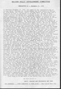
Document - Michele Matthews collection - paperwork and reports for re-zoning of Maiden Gully (1993 - 1996). Residents opposed the re-zoning as they had purchased land as "bush blocks", 25/02/2025
documents for Maiden Gully Sewerage SchemeMichele Matthews collection - paperwork and reports for re-zoning of Maiden Gully (1993 - 1996). Residents opposed the re-zoning as they had purchased land as "bush blocks" Coliban water Annual report 1993/94 21/12/1994 Maiden Gully Development Committee - newsletter No 1 - cttee met with representatives of Coliban Water Caliban Water information Bulletin January 1995 - Maiden Gully Sewerage Scheme 22/02/1995 Maiden Gully Development Committee - newsletter No 2 - cttee activities re the planned sewerage scheme 27/03/1995 - Coliban Water letter to WR & MS Matthews, owners 3 Clay Gully Court (Lot 56 LP 212245) undated - Maiden Gully Neighborhood Sewerage Schemes - Robin Hill Estate Scheme (cost allocation to property owners 21/04/1995 five-page letter of objection/complaint from WR & MS Matthews, owners 3 Clay Gully Court, re costs allocated against their property (Lot 56 LP 212245) 16/06/1995 five-page response from Coliban Water to WR & MS Matthews, owners 3 Clay Gully Court; regarding the outcome of their objection to the sewerage scheme 22/08/1995 letter from WR & MS Matthews, to resident re the results of their objections (and consequent concessions) from Coliban Water re the Robin Hill Estate Sept 1995 Maiden Gully Structure Plan, prepared by TEA planners & Planning Australia Consultants; provides a structure plan, for the Rural City of Marong, the propose future development of the Maiden Gully area Greater Bendigo Planning Scheme - Amendment L43 - Maiden Gully Township: * undated and author unstated - Maiden Gully questions sheet for residents re the proposed Maiden Gully Structure Plan - seven questions and answers * Fauna species - observed /recorded site 6; Maiden Gully (off Pioneer drive) * Explanatory report, three pages * 1/11/1995 Notice of Amendment to a Planning Scheme * Greater Bendigo Planning Scheme, Chapter 6, Amendment L43 (five pages) December 1995 Coliban Water "In the Pipe line", Maiden Gully Region Community Newsletter No 2 - Halfway mark for Sewerage Scheme March 1996 Coliban Water "In the Pipe line", Maiden Gully Region Community Newsletter No 3 - Home stretch for new sewer scheme May 1996 Coliban Water "In the Pipe line", Maiden Gully Region Community Newsletter No 4 - New sewerage scheme comes in well under budget Undated - Maiden Gully Township - Amendment L43 - Panel Hearing report (31 pages) maiden gully, sewerage scheme -
 Greensborough Historical Society
Photograph, Banyule Homestead 2011, 2000c
These photos were part of an objection to the proposed development and subdivision of part of the historic Banyule Homestead property.The Banyule Homestead dates from 1846, owned and built by Joseph Hawdon, sold in 1867 to Dr Martin. Leased to various farmers and eventually the land (274 acres) was subdivided in 1958. The Homestead presently sits on 2 1/2 acres of land. Set of 4 x A3 photos. Colour.Taken from western boundary overlooking lagoon.banyule homestead, joseph hawdon, heidelberg -
Glen Eira Historical Society
Article - Princes Park
This file contains four items. Princes Park information kit (misspelled princess park) compilation (clipped together) of photocopied material about aspects of the park, beginning with Princes Park North East Ground, official report for Glen Eira Council on condition of the park and recommendations for improvements, with blueprints and maps of proposed development. No date but most recent dated page (two letters from Douglas R Aylen, Chief Executive Officer, City of Caulfield, to residents about Princes Park playground is dated 20/05/1991. Includes photocopies of official materials on the purchase of land for the Park beginning in 1920. About sixty pages in all of which several relate to Caulfield Football Club and its campaign for a new pavilion 1967-70. Community News featuring Caulfields Parks and Gardens cutting from Caulfield Contact, 12/1991, on improvements to the park. Photocopy of letter from Rohan Storey Campaigns Coordinator, National Trust of Australia, Victoria to Manager, Planning Section, Glen Eira Council, dated 13/09/2002, headed National Trust Classification of Tree at Princes Park, South Caulfield Quercus suber (cork oak) at Regional level. Includes attached assessment form. Two black and white photocopies of photographs of Princes Park undated from Glen Eira Library Princes Park file, handwritten verso.princes park, parks and resources, glen eira city council, wilson k.d, harris mr, bricker d.c, caulfield football club, victorian football association, princes park trust, evans tim, ladson w.t, dixon r.c, caulfield church of christ, lewis mrs. i.e, caulfield south bowling club, hawkins a.w, briggs j.a, mcdonald s.l, renouf l.s, patience geoff, little ajax football club, gardenvale football club, south east suburban football club, southern metropolitan police football club, caulfield city soccer club, christian brother old boys, caulfield bears cricket club, national trust of australia (victoria), cork oak, tree, storey rohan -
Port Melbourne Historical & Preservation Society
Document - Application for Planning Permit Rex Hotel, City of Port Phillip, 15 Oct 1996
... was for the use and development of the land for the purpose 'of a place... by Lex Carter Pty Ltd was for the use and development of the land ...Two A4 sheets of white paper giving details of the Notice of Application for Planning Permit for the Rex Hotel, 145 Bay Street, Port Melbourne. The application by Lex Carter Pty Ltd was for the use and development of the land for the purpose 'of a place of assembly(club)". The conditions of license are set out on the 2nd page. Rex Hotel 70 pokies Liquor License 9am - 1am Pencil sketch of layout of cnr Bay & Graham Streets.business and traders - hotels, rex hotel, city of port phillip -
Glen Eira Historical Society
Album - Photograph Album, Beauville Estate Album, 2001
Originally labelled "Beauville Estate, Established 1936, Still Thriving 65 years on, 10th March 2001", the Beauville Estate Album contains colour photographs of houses in the Estate. They were taken around the time of the Beauville Estate’s 65th Heritage Celebration held on 10/03/2001 and donated to the Caulfield Historical Society shortly afterwards. Photographer Bev Baxter. Glen Eira’s Heritage Management Plan by Andrew Ward (1996) Vol 2 p78 states that by the end of 1934, the first 3 houses had been built in this housing estate.City of Glen Eira’s Heritage Management Plan Vol 2 p79 (p84 of the pdf version) – HO12 Beauville Estate and environs, Murrumbeena: The Beauville Historic Area is important at the State level as the first large housing estate undertaken by the AV Jennings Construction Co, later Jennings Group Limited, Victoria’s largest home builder. It is important also as a very early estate development incorporating a range of features other than houses and including made roads, shops and recreation facilities. In this respect it was the forerunner of the comprehensively planned housing estate of the post war era. The estate is distinguished by its aesthetic values, as is the earlier and comparable Hillcrest Estate, which are formed by a combination of restrained diversity in house styles, with the exception of no. 30 in the emerging International style, and by a landscaped garden environment.Colour photographs of house exteriors, as well as parks and tennis courts on the Beauville Estate. murrumbeena, houses, beauville avenue, architectural styles, 1930's, inter war style, a.v. jennings, av jennings, jennings, brick houses, beauville estate, murrumbeena road, lindsay avenue, gloucester court, dalny road, a v jennings construction co, beauville estate heritage area, glen eira city council, architectural features, plans, shops, residential development, tennis courts, housing estates, builders, building regulations, local government, commercial development, history, maps, photographs, commercial establishments, jennings group limited, land subdivision, gardens, beauville historic area, sir albert victor jennings -
 Kew Historical Society Inc
Photograph - Country Roads Board and Denmark Street Baby Health Centre, Ron Setford, 1961
Ron Setford and his wife Grace Setford lived in Tanner Avenue, East Kew, from c.1946 to c.1995. A keen photographer, he recorded the changing face of Kew over a 20 year period. Apart from 30 photographs of built structures and places in Kew dating from 1960 and 1961, 145 of his 35mm colour slides chronicle the development of the Eastern Freeway through the Yarra Valley over a five year period from c.1972 to c.1977. This important collection was donated to the Society by his granddaughter in 2025.This collection of 175 35mm slides is of local and statewide significance, owing to its subject matter, particularly the major development of road transport infrastructure during the 1970s with the construction of the Eastern Freeway. The photographer also took care to annotate and date most of his slides which enable the researcher to pinpoint temporal and spatial locations.A photograph providing a visual contrast of the pre and post-World War II architectural styles of the Denmark Street Baby Health Centre and two of the Country Roads Board office buildings. Each was built on part of the land fronting the Kew branch line. In May 1939, the Railway Commissioners agreed to lease a site at the Kew Railway Station for a Baby Health Centre. The single-storey cream brick building was designed by Roland Chipperfield. The Country Roads Board (1913–83), later renamed VicRoads, transferred its headquarters from the Royal Exhibition Building to Kew in 1961, following the completion of two modernist eight-storey office towers in 1960. The VicRoads buildings were closed in 2024, and there is ongoing debate about what replaces them.Nilron setford, photographs -- kew (vic.) -- 1960s, country roads board, vicroads, denmark street -- kew (vic.), denmark street baby health centre -
Lakes Entrance Historical Society
Book - Arthur Phillip, Hughes, Thea Stanley, 1982
An account of the life and achievements of Arthur Phillip, commander of the First Fleet, sent to Botany Bay; the relocation to Port Jackson, and the development of the settlement under his governorship. Written for students.An account of the life and achievements of Arthur Phillip, commander of the First Fleet, sent to Botany Bay; the relocation to Port Jackson, and the development of the settlement under his governorship. Written for students.law, government, land settlement -
 Greensborough Historical Society
Book, Making their mark: The Victorians; by Susan Priestley, 1984_
This text deals with the economic development of Victoria in the 19th and early 20th century.Published to commemorate the 150th anniversary of the European settlement of VictoriaHard cover. 382 pages, illus., maps.victoria land use, victoria economic conditions, victoria history, victoria social conditions, susan priestley, melbourne suburbs -
 Bendigo Historical Society Inc.
Document - MARKS COLLECTION: HISTORY OF FORTUNA
Four pages typewritten history of Fortuna Villa from Mr. Ballerstedt purchasing the mine and land from the Wittscheibe Brothers to the subsequent sale to George Lansell and the various developments.place, fortuna, fortuna villa -
 Eltham District Historical Society Inc
Audio - Audio Recording, Audio Recording; 2018-06-13 Jim Connor and the history of the former Shire of Eltham office site, 13 Jun 2018
June Meeting (Newsletter No. 240, Jun. 2018) Prior to Shillinglaw Cottage (c1878-80) being relocated to where it is now operated as a popular cafe near the Eltham Library, it was within Josiah Holloway’s 1850s subdivision known as Little Eltham, which later became the centre of the first Eltham township. Originally a farmer’s cottage it is historically significant because it is one of the Shire’s oldest dwellings and a fine example of the work of the well-known pioneer builder George Stebbing. In 1964 the then Shire of Eltham purchased the Shillinglaw property with the intention of demolishing the cottage and constructing new Shire offices on the site. However extensive community action resulted in funds being raised to have the building saved and relocated further south to the Eltham Common, where it was joined by the Eltham Library 1994. New Shire offices opened in 1965, but following municipal restructure in 1994 these were demolished and the land sold to a developer, which precipitated a dramatic trail of community angst, threats of legal action, the sacking of a newly elected council and several unsuccessful development proposals, by subsequent councils. After all these years the vacant site there is still guarded by the three trees that were outside the front of the Shillinglaw Cottage. At our Society meeting on Wednesday 13th June 2018 Jim Connor will speak about the dramatic tale encompassing the history of the former Eltham Shire office site and the adjoining War Memorial Buildings complex, which are now being considered for sale or redevelopment by the current Nillumbik Shire Council.1:17:57 duration Digital MP3 File 27 MB audio recording, eltham district historical society, jim connor, meeting, shire of eltham office site, society meeting -
 Eltham District Historical Society Inc
Audio - Audio Recording, Audio Recording; 2018-10-13 Eltham Community Town Hall Meeting, 13 Oct 2018
... process for the re-development of 895 and 903-907 Main Rd, Eltham... process for the re-development of 895 and 903-907 Main Rd, Eltham ...Meeting to discuss the Nillumbik Shire Council's proposed sale and devlopment of the former Shire Office site at 895 Main Road as well as the Eltham War Memorial including the Maternal and Infant Welfare Centre, Eltham Pre-school and Eltham War Memorial Hall and Memorial Gardens at 903-907 Main Road which also includes thje Eltham Senior Citizen's Centre. The meeting was attended by more than 300 people which considered the following: Motion from public meeting – Saturday 13th October, 2018 1. This meeting has no confidence in Nillumbik Shire Council's proposed process for the re-development of 895 and 903-907 Main Rd, Eltham and we deplore the cursory attention given to public consultation to date. 2. We call on Council: *to preserve the Eltham War Memorial building complex at 903-907 Main Rd, Eltham, and retain their existing uses in accordance with the Eltham War Memorial Trust purpose; and retain the Cenotaph and Eltham Senior Citizens' Centre. * to retain council ownership of all land at 895 and 903-907 Main Rd, Eltham for our community and future generations. * following meaningful engagement with residents of the Shire, to place sufficient planning controls on the site of the former Eltham Shire Office to ensure that any future development of that land responds to Eltham's form and character and properly protects public amenity, access and use. * to make all proposals for the development of 895 and 903-907 Main Rd, Eltham available for public inspection as soon as they are received by Council. Moved: Greg Johnson Seconder: Andrew Lemon * carried unanimously1:28:52 duration Digital MP3 File 30.5 MB 895 main road, 903-907 main road, community meeting, eltham pre-school, eltham shire office, eltham war memorial, eltham war memorial hall, infant welfare centre, nillumbik shire council, senior citizen's centre -
 Eltham District Historical Society Inc
Film - Video (DVD), Melbourne and Metropolitan Board of Works, Yarra River Conference Proceedings; a Board of Works centenary event, 13-16 April 1991
Yarra River Conference History Segment [Noted on VHS tape jackets "Due to unavoidable circumstances, the quality of these tapes in some setions is less than desired."] The Yarra River Conference, organised by the Board of Works as part of the Centenary Celebrations, was held in the Board's Head Office Theatrette from 13-16 April, 1991. A segment of the Conference focussed on the role that the Yarra River has played in relation to the historical development of Melbourne. Conceived and presented by a group of prominent historians as a chronological 'trip down the river in time', and profusely illustrated with slides, this segment traced the various impacts that urban and rural growth, development of marine commerce, recreational uses, and environmental problems have had on the Yarra during a century and a half of European occupation. As no formal written paper of this combined presentation is available, these two video-tapes provide a record for anyone who has an interest in tis fascinating aspect of the Yarra's history. The speakers who combined to present this segment are identified on the cover of Tape 2. Tape 1 (2 hours) 1838-1863 Deputy ?? to Utility Early navigators of the Yarra River; developing the port of Melbourne; the gold rush and its effect on the new colony; punts and bridges; water supply; pollution of the Yarra; the discovery of gold and early settlement of the Yarra valley; floods of 1839 and 1863. 1863-1891 Formation of the Harbour Trust; Coode Canal; pollution of the Yarra by industry; aborigines, gold miners, timber getters in the Upper Yarra areas; bridges; the flood of 1891. Tape 2 ( 1 1/2 hours) 1892-1934: People Begin to See Beauty and Romance to the River Henley-on-Yarra; realignment of the Yarra; MMBW is responsible for a sewerage system; new docks to cope with increased overseas trade; development of recreational parks; new reservoirs; timber production and timber tramways; bushfire; flood of 1934. 1935-1970: The River is Neglected Still, Except When it Proves Useful Bushfirs of 1939; the end of many sawmills; birth of tourism; increased interest in conservation and preservation of land for open space; further augmentation of water supply system; birth of containerisation changes the port; environmental concerns gain momentum. Speakers Dr Tony Dingle *, Department of Economic History, Monash University Dr Carolyn Rasmussen *, History Consultant Prof. Graeme Davison, History Department, Monash University Mr. Tom Griffiths, Lecturer in Public History, Monash Uiversity Mr. Patrick Miller, History Consultant Mr. Colin Jones, Author and Historian * Co-authors of the Board's history, 'Vital Connections'.video recording, yarra river, conference proceedings -
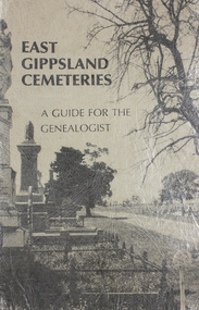 Lakes Entrance Historical Society
Book, Gibson, Tim, Monumental Bairnsdale Cemetery Memories, 1996
A guide to Bairnsdale Cemetery, Victoria, including a plan of the layout, a short history of its development, and genealogical notes of some of the remarkable people buried since commencement.cemeteries, social history, land settlement, memorials -
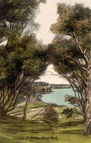 City of Kingston
Postcard - Postcard, Colour, E. Soffa, Glimpse of the sea, Black Rock, c. 1920
Postcards began to be produced in Victoria from 1876. Between 1900 and 1920, picture postcards in Australia became an incredibly popular phenomenon. People could cheaply and easily send messages, without the formality of a letter, and they provided a cheap form of souvenir. Eventually, every event of significance was commemorated in some way with a postcard, and this led to the development of a ‘picture on one side and a message/stamp on the other’ postcard we are familiar with today. They were also a popular form of advertising. This postcard appears to be one in a set of postcards promoting the Black Rock area.Colour postcard feturing a hand tinted photographic image taken from a height, looking down to the sea through bushland.holiday, postcard, black rock, bush land, seaside