Showing 3171 items matching "natural"
-
 Kew Historical Society Inc
Photograph, Floods in North Kew, 1934
Living with natural processes was frequently a challenge to early European settlers and later residents of what was in the 1850s administered by the Borondara Road Board. This was compounded by the area being bounded on three sides by rivers (Yarra River, Koonung Creek and Gardiner's Creek). In 1849, the historian James Bonwick recorded that "our district [Kew] suffered considerably. Mr Wade speaks of 80 acres, out of 100 acres of his cultivated paddock, covered by water." Newspapers continued to describe major flooding in Kew in 1863, 1869, 1878, 1880, 1889, 1891, 1916 and 1934. While the construction of the Upper Yarra dam in 1957 reduced the levels of flowing downstream, local and riverine floods continue.The Kew Historical Society's pictures and map collections testify to the impact of flooding in the district. They have historical importance in documenting the extent of flooding in the district and its affects on homes, services and recreation. Numerous photographs record flooding throughout the Twentieth Century.Floods in North Kew, 1934. Flood near the lagoon (Billabong?)floods (kew) 1934, yarra river -
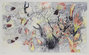 Merri-bek City Council
Lithograph, John Wolseley, After the Fire - Leaf Surge, 2003
British born artist John Wolseley relocated to Australia in 1976, where he travelled extensively through the outback mainly recording the natural history of remote north Australia in large, minutely detailed paintings. Since 2009, he has travelled to Darwin annually to continue his exploration of the Top End, visiting Arnhem Land and Daly River to work with Indigenous artists to research and capture the detail and essence of particular landscapes. His works reflect how landscape can be thought of as fields of energy in which plant forms move or dance with rhythmic life. After The Fire - Leaf Surge represents the vibrant regrowth of new foliage emerging from a landscape recently ravaged by fire. -
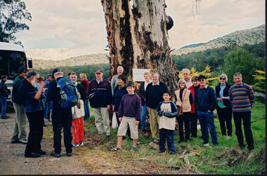 Wooragee Landcare Group
Photograph, 5 Sepember 2004
This photograph was taken at Riverview Farm, Victoria on Sunday the 5th of September as part of a day trip by the Wooragee Landcare Group. The event was about looking at land use on small farms and as a social get-together for the Group. Wooragee was also researching how small landholders could run some enterprises around the time of the trip. This photograph includes Julius Holt, Graeme Missen, Peter and Lesley Finedon, Sue Brunskill, Jacky Luisi, Bonnie Payne, Bob and Christine Stewart, Oliver Payne, and Gerri Boland. Wooragee Landcare Group was created in 1988. Its core mission is to work towards eradicating animals and pests from the land to protect the natural vegetation and promote revegetation projects.This photograph is a great example of the type of events that Wooragee Landcare Group has organized, while educating the public about the importance of land use management.Reverse: WAN NA E0NA2N2. NN1- 3 4556 / [PRINTED] (No. 9) / 188wooragee, wooragee landcare group, wooragee landcare's collection, land use, social, riverview farm, animals, pests -
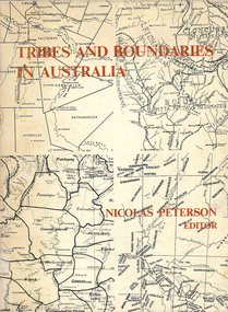 Victorian Aboriginal Corporation for Languages
Book, Nicolas Peterson, Tribes and boundaries in Australia, 1976
Some ecological bases for Australian tribal boundaries /? Norman B. Tindale Man and ecology in the highlands of southeastern Australia : a case study /? Josephine Flood The natural and cultural areas of Aboriginal Australia : a preliminary analysis of population groupings with adaptive significance /? Nicolas Peterson 'The chain of connection' : the material evidence /? D.J. Mulvaney Realities and transformations : the tribes of the Western Desert of Australia /? Joseph B. Birdsell Structure, event and ecology in Aboriginal Australia : a comparative viewpoint /? Aram A. Yengoyan Territoriality and the problem of demarcating sociocultural space /? Ronald M. Berndt Communication and change in mythology /? Kenneth Maddock Levels of organisation and communication in Aboriginal Australia /? D.H. Turner Boundaries and kinship systems in Aboriginal Australia /? F.G.G. Rose Tribes, languages and other boundaries in northeast Queensland /? R.M.W. Dixon Aboriginal language distribution in the Northern Territory /? E.P. Milliken.maps, b&w photographs, diagramsecology, environment, sociology, kinship systems, language distribution -
 Kew Historical Society Inc
Photograph - Grampians, 1924
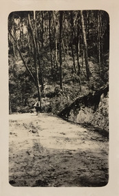
Henry Beater Christian (1886-1962) , was a descendant of one of the earliest settler families in Kew. Employed at the Kew Asylum as a 'public servant', he was a skilled amateur photographer, photographing numerous scenes in Kew and on his travels around Victoria. The majority of his photographs date from 1916 to 1929. His finest photographs are housed in two photograph albums. Digital copy of a photograph from page 12 of the 47-page photograph album containing 261 gelatinous silver images, loaned by Diane Washfold with permission given to digitise and hold a copy in our collection. The first and last pages in the album document the Yarra River at Studley Park and at Kew. The remainder of the album includes photographs of walking and car tours in rural Victoria including 'wilderness' areas in the Grampians, Gippsland and the High Country. Six album pages document a camping trip by Henry Christian to the Grampians in September 1924. The photos include pictures of lookouts, and natural features including rock faces and waterfalls, as well as his camp site. This photo is of a man, perhaps Henry Christian, holding his camera while standing on one of the lookouts on what is probably the Mt Victory trail. The photo was framed in a circle during the development process. "Mt Victory / Grampians / 9.24"henry beater christian (1886-1962), landscape photography, christian-washfold collection, photograph albums, grampians, mt victory, gariwerd -
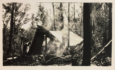 Kew Historical Society Inc
Photograph - Campsite in the Grampians, 1924
Henry Beater Christian (1886-1962) , was a descendant of one of the earliest settler families in Kew. Employed at the Kew Asylum as a 'public servant', he was a skilled amateur photographer, photographing numerous scenes in Kew and on his travels around Victoria. The majority of his photographs date from 1916 to 1929. His finest photographs are housed in two photograph albums. Digital copy of a photograph from page 12 of the 47-page photograph album containing 261 gelatinous silver images, loaned by Diane Washfold with permission given to digitise and hold a copy in our collection. The first and last pages in the album document the Yarra River at Studley Park and at Kew. The remainder of the album includes photographs of walking and car tours in rural Victoria including 'wilderness' areas in the Grampians, Gippsland and the High Country. Six album pages document a camping trip by Henry Christian to the Grampians in September 1924. The photos include pictures of lookouts, and natural features including rock faces and waterfalls, as well as his camp site. This photo is of one of his campsites. The tent, beside which a man is standing, is a simple canvas sheet held up by ropes and supported at one end by large slabs of bark. "Mt Victory / Grampians / 9.24"henry beater christian (1886-1962), landscape photography, christian-washfold collection, photograph albums, grampians, mt victory, gariwerd -
 Kew Historical Society Inc
Photograph - Grampians, 1924
Henry Beater Christian (1886-1962) , was a descendant of one of the earliest settler families in Kew. Employed at the Kew Asylum as a 'public servant', he was a skilled amateur photographer, photographing numerous scenes in Kew and on his travels around Victoria. The majority of his photographs date from 1916 to 1929. His finest photographs are housed in two photograph albums. Digital copy of a photograph from page 15 of the 47-page photograph album containing 261 gelatinous silver images, loaned by Diane Washfold with permission given to digitise and hold a copy in our collection. The first and last pages in the album document the Yarra River at Studley Park and at Kew. The remainder of the album includes photographs of walking and car tours in rural Victoria including 'wilderness' areas in the Grampians, Gippsland and the High Country. Six album pages document a camping trip by Henry Christian to the Grampians in September 1924. The photos include pictures of lookouts, and natural features including rock faces and waterfalls, as well as his camp site. This is a photo of a man in the distance on a bush track who is looking over his shoulder at the camera. He carries a sack and has a swag on his back. This may be Henry Christian or a companion."Grampians"henry beater christian (1886-1962), landscape photography, christian-washfold collection, photograph albums, grampians, gariwerd -
 Federation University Historical Collection
Document, Retirement of Alan Sonsee, 1976, 08/1976
Born in 1911, Cecil Alan Sonsee lived at Springmount near Creswick, and taught natural history at the Ballarat Teachers' College for 30 years. His teaching career stretched over a 48 year period. He spent six years as a student teacher before reaching the position of first class teacher. He had the distinction of never attending a teachers' college, but spending half his teaching career training students to become teachers. At the time of his retirement Mr Sonsee said during his years at the college, "the training had changed from a one year course to a two year course, followed by a three year course, and now a four year course was offered." He recalled "in the early days all country schools had eight grades and a child finished with a merit certificate. Today [1976], children went to high schools from sixth grade and most of the country schools had disappeared.' Alan Sonsee spent 10 years on a television program on BTV6 answering questions sent by viewers regarding aspects of plant and animal live. Mr Sonsee was a life member of both Creswick and Ballarat Field naturalists Clubs. Alan Sonsee died in 1985.1) Foolscap Department of Victoria Ballarat newsletter titled Education 'Regional Views'. The newsletter depicts an image of Alan Sonsee and outlines his career at the time of his retirement on 20 July 1976. The author of the newsletter is unknown. .2) newspaper article on the retirement of Alan Sonsee dated 25 August 1976 (probably from the Ballarat Courier).1) Mr "Nature Man" Retires After a quiet celebration, Mr C.A. Sonsee, a well-known staff member at Ballarat State College, retired from the Victorian Education Department on 20th July, 1976. Alan was the longest serving primary teacher seconded to the State College (Formerly the Ballarat teachers' College), probably the best known and certainly one of the most highly respected educationalists in this region. Leaving Ballarat high School in 1927, he spent the following years teaching at Smeaton, Willowvale, Lawrence (originally called Jerusalem) and Kooroocheang primary schools. However, during the last twenty-nine years, his fame and his influence spread further and further afield. From 1947 to 1976, under a number of principals, Alan endeared himself to thousands of students undergoing their tertiary preparation for teaching. And thousands is the word! Hundreds and hundreds of practising teachers of all ages came to this great teacher again and again for assistance in understanding natural phenomena, a broad field in which he is an acknowledged expert. What undoubtedly made him so accessible to the young and the no-so-young alike was his ready willingness to share with them is rich experience. The warmth of his nature, his kindliness, his dry humour enriched and enlivened the gifts he lavished liberally on all who needed help. Nor did he spare himself in the process. During his ling period of service to teachers, students and some two generations or so of school children, Field Naturalists also, within and well beyond Ballarat, profited from his participation and guidance. A car trip from Ballarat to Lancefield was made unforgettable by Alan's running and lively commentary; the time spent with him viewing and fossicking in an aboriginal flint area is still vivid, thouhg many moons have waxed and waned since then. And who can ever forget his palcid, home;y handling of "Mr nature Man" programmes on BTV 6 for over ten years? his name became a hose-hold word over an existence viewing area in Western Victoria - as his mail bag showed. Mr T. Turner was closely associated with C.A.S. for some twenty-three years as colleague and college principal. Recently tome said, "Alan was highly esteemed by staff and students, When I saw him lecturing I would be struck by the depth and breadth of his knowledge, and by the smooth, almost deceptively simple way he shared what he knew with others. I remember, too, his consideration for the views and the feelings of others; for the tolerance and range of his understanding of human nature. But, above all else, I remember him as a friend." All who know him in any way at all will want to say, "Thanks you, Alan, for everything you did for us. Thank you, Alan for what you are."alan sonsee, ballarat teachers' college, ballarat state college, education, teaching, ballarat field naturalists, creswick field naturalists, aborigines, lancefield flint, smeaton primary school, willowvale primary school, lawrence primary school, jerusalum primary school, kooroocheang primary school, nature studies, mr nature man -
![Photograph - Digital image, House St Helena and Diamond Creek Roads [Greensborough], 02/05/2013](/media/collectors/4f729f5697f83e03086015b8/items/5729bbd22162f108e8de5be2/item-media/5729bc112162f108e8de617d/item-fit-380x285.jpg) Greensborough Historical Society
Greensborough Historical SocietyPhotograph - Digital image, House St Helena and Diamond Creek Roads [Greensborough], 02/05/2013
These photographs of the house on the corner of St Helena and Diamond Creek Roads was taken in 2013 to show changes over 40 years, based on Ron Reynold's sketches in the 1973 publication 'Greensborough and Greenhills' published by Cypress Books... which states "Built on a steep hill in a bush setting in the early 1920s, for a Dr Wood, the weatherboard house now overlooks an area of activity and change. The owners, Mr and Mrs E. 'Bluey' Blackburn, remember when their 3/4 acre building block dropped to the edge of a dirt road. Today the view from the high verandah encompasses the Main Street shopping centre, new and old bridges, new roads and houses, the Plenty River, natural bush, hills and sports grounds."Digital copy of colour photograph.greensborough and greenhills, st helena road greensborough, diamond creek road greensborough, wood family, ron reynolds -
 Glenelg Shire Council Cultural Collection
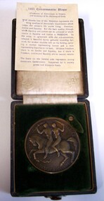
Plaque - Plaque - 1951 Commemorative Plaque, 1951
1951 Commemorative Plaque (Centenary of Government in Victoria and Centenary of the Discovery of Gold) THE obverse side of this Medallion represents the three qualitities of democratic Government which makes the citizen's life worth living. Freedom, Justice and Equality. But the basic quality, through which Equality and Justice can be achieved or which results in Equality and Justice is FREEDOM. So the artist, in agreement with the sub-committee, selected a beautiful horse, gallantly bounding forward, his broken shackles still on his foreleg, carrying a woman representing Justice and a man representing Equality on its back. Without Freedom there is no Justice and Equality, but if there is Freedom, Justice and Equality are its natural results. The Stake on the reverse side represents strong democratic Government. Supported by it society grows and blossoms freely.Medal: OBVERSE: Depiction of a bucking horse with two nude riders. The first rider is a man wielding what appears to be a torch. The second rider is a blind folded woman wielding a sword. The horse has a broken shackle on the left foreleg. Information sheet in case. Case: Black leather, white satin lining and green velvet insert. Top bears gold coat of arm of Government of Victoria.Front: Equality and Justice through freedom. Back: CENTENARY OF THE GOVERNMENT OF VICTORIA 1851-1951 (edge) Presented to THE TOWN OF PORTLAND 1951 (engraved, centre)medal, commemorative, centenary, victoria -
 Kew Historical Society Inc
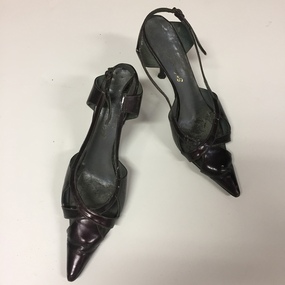
Footwear - Pair of Black Leather Stilettos, Schumacher, 1980s
The extensive fashion and design collection of the Kew Historical Society has been assembled over a number of decades. One subsection of this collection is shoes, designed and manufactured for Australian women by Australian and European designers. Many of the shoes, while often mass-produced, were generally constructed by skilled artisans using traditional shoe-making techniques. The shoes date from the 1890s to the 1980s. Schumacher Shoes was a family owned and operated retail show store in Melbourne who sought out the best in comfort, design, and style features. Brands are sourced from around the world, including renowned German, French, Italian; Spanish seasons collections. Made from, including sustainable, quality natural; man made materials.Black leather shoes, with high stilettos heels sling backs with a narrow pointed toe, designed by Schumacher of Collins Street, Melbourne.Schumacher / 296 (sic) Collins Street / Melbourneschumacher, women's shoes, footwear -
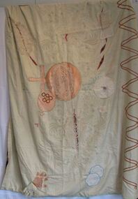 Queen Victoria Women's Centre
Re-purposed Quilt, Patsy Coverdale, The Century Bedspread, c.1975
Patsy Coverdale wrote on about the artwork which is found with the bedspread "This trousseau bedspread commemorates a century of our daily living, of four generations, a bedcover where many loves and lives have begun and ended. Once immaculate, its years of service, of blood, sweat and tears, have seen so many building washes that today's embroideries would shrink from. I rescued it, patched its tears and wears with needlework from ancestors and aunties to celebrate the International year of Women in 1975. It symbols include the IYW to the left, women's work and its rhythms and cycles, a pearl button for our pleasure centre. The male phallic symbol illustrates the organ's early development and its natural power with the energy of relativity behind it all."A quilt made for the centenary of the Hospital made for the International year of women 1975. Re-purposed from a quilt used at the hospital. Given to QVWC in 1997 for the grand opening. textile art, centenaries, hospitals -
 Phillip Island Conservation Society Inc.
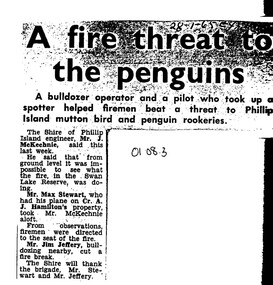
Work on paper - Photocopy of newspaper cutting, Wonthaggi Express or Powlett Express newspaper, "A fire threat to/the penguins", 28.01.1965
The article describes a fire incident which took place in January 1965 at Swan Lake, a water reserve at the entrance to Summerland Peninsula, Phillip Island. Due to an extremely heavy infestation of gorse (noxious weed) and natural tea tree scrub, along with poor vehicle access, the volunteer fire fighters could apparently not gauge the extent of the fire. A light plane operator visiting Cr Arthur Hamilton nearby was able to fly Phillip Island Shire Engineer, Jock McKechnie, over the lake to better direct the fire fighters. Swan Lake has many Bunurong Aboriginal middens and short-tailed shearwater rookeries, and, being not far from the Penguin Parade, a fire there posed a direct threat to the birds. The article is significant because it indicates the vulnerability of the Summerland Peninsula reserves to fire, the way the Shire Engineer, local bulldozer contractor and volunteer fire fighters tackled the fire outbreak. photocopy of newspaper cutting. Dark copying at top. Double column heading. Single column black text on white paper28-1-65 EXswan lake phillip island, summerland peninsula, bunurong aboriginal middens, short-tailed shearwaters, mutton birds, little pengiuns, penguin parade, jock mckechnie, cr arthur hamilton, fire fighters, , max stewart, jim jeffery -
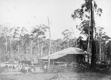 Stawell Historical Society Inc
Photograph, Saw Mills at Childe’s Glenbower Creek in Halls Gap 1866
Saw Mills Halls Gap (Childe’s Glenbower Creek). Part of a collection of Photographs by Mr. O.G. Armstrong as commissioned by the Shire of Stawell for the Inter-colonial and Paris Exhibition in Melbourne in 1866. During the years of gold, the hardwood forests around Stawell were ravaged to provide timber for the mines. It was used undergrounds to shore up workings, and millions of feet of it were fed into furnaces and kilns in which the quartz was roasted. In the years after the gold boom, hardwood from the Grampians was milled for building timber. Wherever there are large tracts of natural bushland, fires are always a danger. A huge fire in January 1939 caused havoc in the Grampians, burning out towns and sawmills such as the one pictured. There have been no sawmills in the Grampian since that fire. stawell industry -
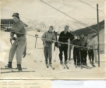 Kiewa Valley Historical Society
Photographs – Skiers at Falls Creek – Set of 10 black and white photographs
After World War II, the Kiewa Hydro-Electric Scheme was started in the Kiewa River valley by the State Electricity Commission of Victoria. On land previously used only for summer cattle grazing in the natural alpine grasslands, the first ski lodge was built in 1948 by workers from the hydro scheme as skiing was a popular recreation. Many of the hydro employees were of European background and had grown up enjoying skiing and snow sports in their homelands and were keen to continue to pursue their winter sports interests. The first lift, a rope tow, was built in 1951 and the first chairlift in Australia was constructed there in 1957. Two T-Bars were opened in 1961. In 1964, the Victorian Municipal Directory recorded that Falls Creek had 29 ski club lodges and 16 commercial lodges.Employees of the State Electricity Commission of Victoria in the Kiewa River Valley were the earliest skiers on the Bogong High Plains and built one of the first ski lodges at Falls Creek. They were amongst those pivotal in the development of the skiing and tourist industry at Falls Creek and on the Bogong High Plains. Set of 10 black and white photographs of various skiers at Falls Creek Victoria1. From Left-John Robertson Myrtleford; Bill Bridgford, St Trinians; Girl not known; Roy Wolpole, Myrtleford; Fin McAuliffe, Myrtleford; Looking on foreground, Toni St Elmo 2. Falls Creek. Property of State Electricity Commission of Victoria Publicity Photo Negative No PB4046. Publicity Branch, 15 William St Melbourne. 3. Avic Lajons 4. No markings 5. Bill Bridgeford (lower person on slope) 6. Max Lawrence? Facing skiers 7. 6575. Indistinguishable red stamp on back 8. 6875. Ces Dobson on tractor 9. From left on tow. John Robertson (Myrtleford); Bill Bridgeford (St Trinians); Girl unknown; Roy Walpole (Myrtleford); Vin McAuliffe (Myrtleford); Looking on foreground Toni Beveridge. 10. From Left 1; 2; 3. Bill Bridgeford; 4. George McPherson ? (Myrtleford); 5. John Robertson (Myrtleford); 6. Elsbeth Rollenson? (Myrtleford); 7; 8; 9. 11. Bogong. Looking N.E from Big River fire track. Skiers on way to Falls Creek. Spion Kop on left. Going around Ropers Cerner near the 18 mile post falls creek, skiing, bogong high plains -
 Kiewa Valley Historical Society
Postcard Circa 1950, Mt. Beauty Village, Kiewa Hydro-Electricity Project, circa 1950
This postcard was produced in the 1950's for the tourist trade in the Kiewa Valley and Alpine region. It encompasses the period when the State of Victoria was pressured by the ever increasing demand by industry and its population for electricity supplies. Hydro electricity was seen as an untapped natural resource to quench this demand. The Victorian Alps and the rivers flowing into its valleys was ideal for the construction of the Kiewa Hydro Electricity Scheme. The late 1940's saw the development of this scheme and the changing of sections of alpine landscape is covered by this and other postcards/pictures (tourists, construction workers, and established rural populations). This period in time was before the established wildlife and forest/nature groups became political activist who changed legislative acts to protect the environment. The regulatory pondage on the northern aspect of the village had no water over-spill from the unfinished power station.This rural region in 1950 (Kiewa Valley/alpine plains) was at most only significant to a smaller group of winter sports, summer hikers/horse riders and rural farmers/graziers. The numbers of tourists and the increase in the local resident population was boosted by the construction of the Hydro Electricity Scheme. This influx to the regional population resulted in a corresponding diversity in services and brought about an environment that responded to a growing level of tourists and thereby permitting this industry to grow more rapidly than it would have naturally. This postcard details an attraction to the "cleaner" method of providing electricity. This postcard was purchased in 1950 by a surveyor at Landford's Gap. The couple shown in this photograph would have been employed by the S.E.C. under the Kiewa Hydro-Electricity Scheme.This item is a scanned black and white photograph of a panoramic view of Mount Beauty Village in 1950 (a closed village, entry by pass only). The regulatory pondage has earthen walls but no water.See 0480 (A) -(D) and (F) for other photos of similar postcards"MT. BEAUTY VILLAGE KIEWA HYDRO-ELECTRIC PROJECT"kiewa valley tourism, victorian alps, alternate energy supplies, alpine population growth -
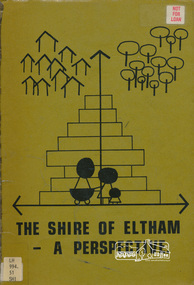 Eltham District Historical Society Inc
Book, Shire of Eltham, The Shire of Eltham - A Perspective, July 1981
This report was produced by the Shire of Eltham (Planning Department) following a population study of the Shire. It also includes other areas of general interest. The Document contents includes Present and Future - Population - Housing - Residential Lands - Social Characteristics - Development and History. Includes maps, tables and diagrams. Part 1: The Existing situation - introduction, the Shire of Eltham, physical characteristics, historical development, population growth. Characteristics of the population - size and distribution, age / sex, natural increase, migration. Socio-Economic Factors: socio-economic status, employment/workforce, education, other social factors. Housing/ building statistics: characteristics of Housing stock, current residential trends, other types of building activity. Residential Land: existing vacant lots, estimated additional lots. Part 2: The Future. Land availability, the future population.The Shire of Eltham Council resolved on publication of this report "to commend it to the ratepayers as a most valuable resource document". It provides a comprehensive statistical review of the Shire of Eltham, Victoria in 1981 with some population and development predictions for the future.Spiral bound, soft cover, includes indexBarcode and identification markings including stamped "WITHDRAWN" from Heidelberg Regional Library Serviceshire of eltham, planning, population -
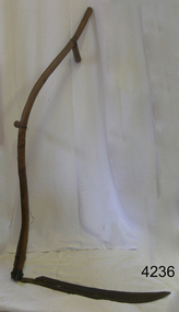 Flagstaff Hill Maritime Museum and Village
Tool - Scythe, 1930-1960
A Scythe was one of the most important of all agricultural hand tools, consisting of a curved blade fitted at an angle to a long, curved handle and used for cutting grain. In modern scythes the handle has a projecting peg that is grasped by one hand, facilitating control of the swinging motion by which grass and grain are cut. The exact origin of the scythe is unknown, but it was little used in the ancient world. It came into wide use only with agricultural developments of the Carolingian era (8th century AD) in Europe, when the harvesting and storing of hay became important to support livestock through winters. Scythes can still be found in use today by hobby farmers and permaculturists. ( producing food, by using ways that do not deplete the earth's natural resources) to cut grass in a more eco-friendly way as opposed to using a machine.A hand tool used for the cutting of crops and grain, modern versions are still being produced today in Europe. The subject item gives us a snapshot into agricultural practices in times past.Scythe with long wood Snath (curved handle) with 1 hand holding piece & curved blade. Noneflagstaff hill, warrnambool, shipwrecked-coast, flagstaff-hill, flagstaff-hill-maritime-museum, maritime-museum, shipwreck-coast, flagstaff-hill-maritime-village -
 Robin Boyd Foundation
Document - Script, Robin Boyd, University of the Air. Design in Australia 8. Conclusions, 1964
Robin Boyd was involved in creating several TV series for the ABC University of the Air. 'Design in Australia' was an eight part series. (Items D184-D193 contain all the manuscripts except part six titled 'Communications'.) In part 8, Boyd concludes his lecture with an overview of the state of Australian design. Boyd points to the uniqueness of Australia's natural landscapes and asks a series of pointed questions, implying that Australian design does not reflect or match up to its context. In Boyd's view, Australia now produces world-class designers, but lacks a world-class design culture, leading the best professionals to leave for the US or UK. Boyd concludes by arguing that Australian design culture can be developed into something both connected to the rest of the world and still uniquely Australian.This is a draft script for the ABC television program 'University of the Air', subtitled 'Design in Australia', broadcast in 1965.Typewritten (c copy), foolscap, 12 pagesInscription in pencil on p.8 - "good ideas (Kings + fountain)"university of the air, design in australia, robin boyd, henry lawson, d.h. lawrence, kangaroo novel, canberra, manuscript -
 Queenscliffe Maritime Museum
Instrument - Azimuth Mirror
William Thomson described a new "Marine Azimuth Mirror" at the 1877 meeting of the British Association for the Advancement of Science, and patented the design in Britain and the U.S. This instrument is an example of the improved design, with a reflecting prism in place of the original mirror. Thomson introduced this form in the early 1880s. The signature indicates that it was made during the period 1900-1913. A child prodigy, William Thomson went to university at the age of eleven. At twenty-two he was appointed Professor of Natural Philosophy in Glasgow where he set up the first physics laboratory in Great Britain and proved an inspiring teacher. He primarily researched thermodynamics and electricity. On the practical side he was involved in the laying of the Atlantic telegraph cable. He was also the partner of a Glasgow firm that made measuring instruments from his own patents.An instrument of significant importance which made marine navigation easier and more accurate in the early twentieth century.An Azimuth mirror with wooden box.Kelvin & Hughs Ltd Serial No - illegible Made in Great Britainazimuth mirror, william thompson, lord kelvin, naviagtion, marine instruments -
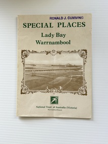 Warrnambool and District Historical Society Inc.
Pamphlet - Special Places Lady Bay Warrnambool, Philprint Warrnambool, 1989
This pamphlet was produced for the Warrnambool Branch of the National Trust of Australia (Victoria) for Heritage Week, April 16-23, 1989 and contains information written by Warrnambool residents about their locality. This was a co-operative venture by people with a common interest in protecting the natural environment near their home. Areas covered in the written information include: Formation of the Coast, Archaeological survey, Gunditjmara History, vegetation, history and recreational uses of the Lady Bay area. The map shows special places of interest including past and present navigational aids, sites of shipwrecks and other historical places of interest. The Warrnambool Branch of the National Trust was originally formed in March 1969 and merged with the Port Fairy Branch in late 1970. In October 1979, the Warrnambool Branch was reformed and operated into the late 1990's. This is an example of a publication produced by the Warrnambool Branch of the National Trust Australia (Victoria). It provides historical information and perspectives of the recreational uses in and around Lady Bay Warrnambool.An A2 piece of buff coloured thick paper folded into eight to make an A5 pamphlet. The front cover has green printing with the National Trust symbol of three eucalyptus leaves in green. There is a brown sepia photograph showing a view across Lady Bay with the suspension bridge across the Merri River in the foreground, Viaduct Road in the middle ground and the breakwater in the background. There is a purple inked stamp on the top right hand corner. The rear cover has brown writing and includes logos of bodies who assisted with the publication. There is a brown line drawing of the viaduct and pier at the Warrnambool Breakwater. The inside of the unfolded pamphlet contains a map of Lady Bay and adjacent area showing places of interest and shipwrecks marked in red circlesFront cover: Special Places Lady Bay Warrnambool National Trust of Australia (Victoria) Warrnambool Branch Ronald J. Cummingwarrnambool, lady bay warrnambool, national trust australia victoria warrnambool branch, heritage week 1989, lady bay shipwrecks -
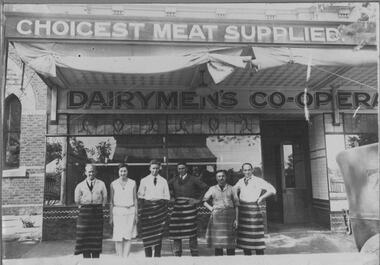 Bacchus Marsh & District Historical Society
Photograph, Dairymen's Co-operative Butchers Shop. Main Street Bacchus Marsh. 1923
Bacchus Marsh Dairymen's Co-operative Association factory began in 1910. The Co-op, as it was known locally, also had a store in Main Street. This butcher's shop was opened in 1923 and was located at 160 Main Street. The Co-op purchased milk from local farmers and trucked the milk direct to a factory in Melbourne. Due to financial difficulties, the Co-op ceased trading in the early 1980s. Records show that this site was in continuous use as a butcher's and allied industries from 1856 to 2011. The original building underwent several changes and additions until it was sold in 1922 to the Dairymen's Co-operative, who erected a new brick building in 1923. This building housed the Hospital Opportunity Shop from 2011 until 2016 when it was taken over by Natural Health and is still in use by this business.Black and white photographic print mounted on grey cardboard with decorative borders. Photo shows staff standing in front of the shop with two store signs. Along the top the verandah a sign reads: CHOICEST MEAT SUPPLIED. The lower sign along the top of the shop frontage reads: DAIRYMEN'S CO-OPERA. This sign is incomplete, indicating that the butcher's shop was part of the Dairymen's Co-operative Association store. At the front of the store six members of the staff stand in a line. There are five men, all wearing the traditional blue and white striped butcher's apron and one woman who is probably the cashier. At the top of the cantilever verandah, two rolls of canvas awning are tied up, ready to be let down on a hot day. On the left of the photo a portion of the brick Baptist Church can be seen. The store frontage continues to the right. The reflection of the store on the opposite side of the street can be seen in the window. The store frontage is finished with tiles along the bottom of the display window and an inset of leaded glass along the top of the window. On the footpath there is a scattering of sawdust, once used traditionally in butcher shops to soak up blood from the meat. The end of a 1920's vehicle has been captured as it passes in front of the store. On the back: On a printed label: OPENING OF BACCHUS MARSH DAIRYMAN'S CO-OPERATIVE BUTCHERS SHOP. 1923 L. to R. Norm Farrow, Sheila Muir, Bill Bence, Norm Mathews, Jim Cash and Ern Coe, (Manager). shops bacchus marsh vic., bacchus marsh dairymen's co-operative association, butcher's shops, main street bacchus marsh vic. -
 Stawell Historical Society Inc
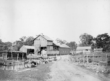
Photograph, Fountain Head Brewery at Armstrong 1866
Fountain Head Brewery Armstrong's. Part of a collection of Photographs by Mr. O.G. Armstrong as commissioned by the Shire of Stawell for the Inter-colonial and Paris Exhibition in Melbourne in 1866. The brewery, a three-storey high building, was established close to two streams which joined the Concongella Creek near Armstrong, although the water required to run the brewery was obtained from a natural underground spring which is still visible. Further findings of Gold in Victoria around 1859-1860 brought a large rush of miners to the area. Some stayed on to become merchants, farmers, etc. Jens Kofoed, a shipwright from the Netherlands, was one who came to the area at this time. He and his family move to Armstrong in 1860, establishing the Fountain Head Brewery, which employed quite a number of people for about 40 years. stawell industry -
 Sunbury Family History and Heritage Society Inc.
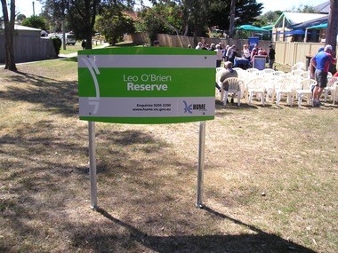
Photograph, Leo O'Brien Reserve, November 2015
The sign was erected in the reserve in November 2015. Leo O'Brien was a long time Sunbury resident and the son of Terence O'Brien, who farmed in the district. The reserve is on a section of land that Leo owned, which fronted Barkly Street to the west and Jackson Street to the east. As Sunbury developed the higher section of the property was subdivided for housing and today Terence Street is in that subdivision. The Leo O'Brien Reserve area could not be developed for housing because that land is part of the former main drain, which was a natural waterway that flowed through a part of Sunbury an entered Jacksons Creek at the end of Brook Street. Today the open drain is covered over. Terrence O'Brien served as Shire President on Shire of Bulla Council during the first two decades of the twentieth century and was also a member of the Sunbury Waterworks Trust from 1913 - 1914.A coloured photograph of sign placed at the entrance of a small open space. Tables and chairs have been set out for refreshments in the reserve.leo o'brien, leo o'brien reserve, terence o'brien -
 Wooragee Landcare Group
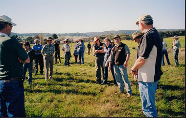
Photograph, 27 August 2004
This photograph was taken on Friday the 27th of August 2004 as part of an event called 'Direct Seeding Expo'. This event was one of many held by the Wooragee Landcare Group in the early 2000s which aimed to educate the local community on certain agricultural and biodiversity conservative techniques. This particular photograph shows attendees at the property of Neil and Anne Nankervis, inspecting sites where direct seeding had been used ten months earlier. Three different direct seeding techniques were demonstrated during the day by several experts in the field. Direct seeding involves the sowing of seeds directly into the soil to achieve germination and establishment. It is an alternative to planting seedlings in a contained nursery plot. This direct method is intended to mimic a more natural process of growth, revegetating larger areas in a more efficient manner.This photograph is significant as it provides evidence of a project undertaken by the Wooragee Landcare Group in the early 2000s to educate members of the public on alternative and potentially more efficient methods of planting seedlings. The Wooragee Landcare Group has been instrumental in the co-ordination of programs relating to biodiversity protection in the local area, providing great assistance to landholders.Landscape coloured photograph printed on gloss paperReverse: WAN NA EONA2N2. ANN+ 1 4240 / neil and anne nankervis, wooragee, wooragee landcare group, wooragee landcare, direct seeding expo, direct seeding, seeding, seedlings, direct seeding sites, alternative seeding, alternative seeding method -
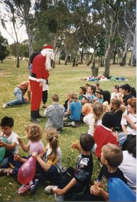 Broadmeadows Historical Society & Museum
Photograph - Group Photograph, Santa in the Sunshine: A Park Day Surprise, 1990
This photograph, taken during Jacana Primary School’s 1990 Christmas picnic, captures a relaxed and festive moment believed to have occurred at Greenvale Reservoir, a popular recreational destination in Melbourne’s northern suburbs. The image shows a group of children seated on the grass, engaging with a person dressed as Santa Claus, who is standing and interacting warmly with them. Balloons and a natural backdrop of trees contribute to the cheerful, outdoor atmosphere. The event reflects the community spirit and traditions of the time, where schools often organised end-of-year gatherings to celebrate the holiday season. Greenvale Reservoir, known for its open spaces and family-friendly environment, served as an ideal location for such festivities. This photograph offers a glimpse into the social and cultural fabric of suburban Melbourne in the early 1990s, highlighting the importance of communal celebration and childhood joy.This photograph holds cultural and historical value as a visual record of Jacana Primary School’s 1990 Christmas picnic, believed to have taken place at Greenvale Reservoir, a cherished recreational site in Melbourne’s northern suburbs. It captures a moment of community celebration, showcasing the traditions of Australian public schools in the late 20th century, where end-of-year gatherings fostered social bonds among students, families, and staff. The presence of Santa Claus engaging with children in an informal outdoor setting reflects the blending of festive customs with local recreational culture. The image is significant not only for its depiction of childhood joy and seasonal festivity but also for its connection to the broader social history of Melbourne’s suburban communities. It offers insight into the ways schools and families utilised public spaces to create meaningful shared experiences, contributing to the collective memory of the area. As a document of place, time, and tradition, this photograph is a valuable artifact for understanding the lived experiences of school communities and the role of public spaces in fostering social cohesion.Colour photograph on glossy paper in portrait format.PH18289 (crossed out) PH4209 (crossed out) PH-4868jacana, jacana primary school, christmas picnic, 1990, father christmas -
 Kew Historical Society Inc
Photograph, J F C Farquhar, The Yarra in Hyde Park, 1891
At the beginning of the 1890s, the Kew businessman and Town Councillor, Henry Kellett, commissioned J.F.C. Farquhar to photograph scenes of Kew. These scenes included panoramas as well as pastoral scenes. The resulting set of twelve photographs was assembled in an album, Kew Where We Live, from which customers could select images for purchase.The preamble to the album describes that the photographs used the ‘argentic bromide’ process, now more commonly known as the gelatine silver process. This form of dry plate photography allowed for the negatives to be kept for weeks before processing, hence its value in landscape photography. The resulting images were considered to be finely grained and everlasting. Evidence of the success of Henry Kellett’s venture can be seen today, in that some of the photographs are held in national collections.It is believed that the Kew Historical Society’s copy of the Kellett album is unique and that the photographs in the book were the first copies taken from the original plates. It is the first and most important series of images produced about Kew. The individual images have proved essential in identifying buildings and places of heritage value in the district.Hyde Park is now a small recreation reserve bordered by Willsmere and Kilby Roads and White Avenue. In 1982, Hyde Park was cut off from the Yarra River by the construction of the Eastern Freeway. The building of the latter was to transform the natural landscape, including the Yarra, as well as Hyde Park. The construction of the Freeway makes it difficult to view the scene with the photographer’s eye. Today’s Hyde Park is located on land purchased in 1847 by John Cowell, and in 1851 Catherine Cowell, yet the scene selected by the photographer may well have been located on farmland owned by the Wills family. Farquhar’s point-of-view emphasises both the pastoral and recreational elements of the scene: the grazing cows, three boys, and in the distance two figures, seated on the bank with a parasol. By 1891, an environmental consequence of human activity, including farming, was deforestation, leading to the erosion of the south bank of the Yarra. In contrast, the land on the Alphington side of the river in 1891 included remnant bushland.The Yarra in Hyde Parkkew illustrated, kew where we live, photographic books, henry kellett, yarra river -
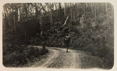 Kew Historical Society Inc
Photograph - Bushwalking on road between Glen Wills and Lightning Creek, c.1925
Henry Beater Christian (1886-1962) , was a descendant of one of the earliest settler families in Kew. Employed at the Kew Asylum as a 'public servant', he was a skilled amateur photographer, photographing numerous scenes in Kew and on his travels around Victoria. The majority of his photographs date from 1916 to 1929. His finest photographs are housed in two photograph albums. Digital copy of a photograph from page 32 of the 47-page photograph album containing 261 gelatinous silver images, loaned by Diane Washfold with permission given to digitise and hold a copy in our collection. John Chapman has written in 'Bushwalking Clubs - A Brief History', about the establishment in Victoria of the first bushwalking club in 1888, and the popularisation of bushwalking during the interwar period. Henry Christian's 'walks' appear to have been undertaken solely or with a companion/s. This black and white photo is part of a group of photos taken in the Victorian High Country. The page is labelled 'Near Glen Wills & Lightning Ridge" and includes photos of bush tracks, family groups, and natural features. The small black and white photo depicts a bushwalker, either Henry Beater Christian himself, or a companion, on a mountain road between Glen Wills and Lightning Creek. The walker carries a knapsack. His outfit includes a hat and gaiters."NEAR GLEN WILLS & LIGHTNING CRK"henry beater christian (1886-1962), landscape photography, christian-washfold collection, photograph albums, bushwalking, northeast victoria, victorian high country, glen wills, lighting creek -
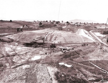 Wodonga & District Historical Society Inc
Album - Hume Reservoir Australia Album - Earth embankment on Victorian side from Top of Tail Tower Pillar, August 1927
This set of photos is from a leather bound album bearing the inscription "HUME RESERVOIR AUSTRALIA" plus 'The Rt. Hon. L. C. M. S. Amery, P. C., M .P.' all inscribed in gold. It was presented to The Rt. Hon. L. C. M. S. Amery, P. C., M. P, Secretary of State for Dominion Affairs on the occasion of his visit to the Hume Reservoir on 2nd November 1927. This album is of local and national significance as it documents the planning and development of the Hume Reservoir up to 1927. It was the largest water reservoir in the British Empire. The album records the pioneering engineering work that went into its construction.DEPARTMENT OF PUBLIC WORKS, N.S.W. RIVER MURRAY WATERS SCHEME. HUME RESERVOIR. 31. View from Top of Tail Tower Pillar - Earth Embankment, Victoria. This is a general view of the embankment which is being constructed by the Victorian Constructing Authority. The bank at its base is about 650 feet wide and it is about half its ultimate height. In the middle is the reinforced concrete core wall. At about the natural surface a tunnel for drainage and inspection purposes is built along the downstream side of the core wall but this cannot be seen. The Victorian workshops and township are located on the high ground beyond the embankment. The embankment curves round to the left at the side of the valley and will eventually block the gulley where the bushy tree stands. Access to one of the cuttings from which material is being got for the embankment is gained by means of this gulley at present. Part of another cutting may be seen on the right hand side at the back. August 1927.hume reservoir australia, river murray waters scheme, hume reservoir construction -
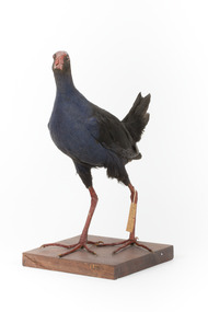 The Beechworth Burke Museum
Animal specimen - Australasian Swamphen, Trustees of the Australian Museum, 1860-1880
The Australasian swamphen is a visually striking and socially complex bird found across Oceania. It can be found in eastern Indonesia (specifically the Moluccas, Aru, and Kai Islands), Papua New Guinea, New Zealand, and Australia. As a member of the rail family (Rallidae), it belongs to the diverse order Gruiformes, which also includes cranes and other rail species. Like other rails, it possesses relatively short wings and a strong, elongated bill, both adaptations suited to its semi-aquatic wetland habitat. This swamphen is easily identified by its deep blue-purple plumage, prominent red frontal shield, and sturdy red legs. It primarily inhabits swamps, marshes, and other wet lowland areas, though its range has expanded to include pastures, roadsides, and farmland due to significant landscape modifications over the past 150 years. Unlike many wetland birds, it is highly adaptable and thrives in both natural and human-altered environments. Its diet is similarly flexible, consisting mostly of plant material such as grass stems, shoots, and leaves, but also including invertebrates and, on occasion, the young of other bird species. This specimen was misidentified as a Purple Swamphen in original catalogue records and is part of a collection of almost 200 animal specimens that were originally acquired as skins from various institutions across Australia, including the Australian Museum in Sydney and the National Museum of Victoria (known as Museums Victoria since 1983), as well as individuals such as amateur anthropologist Reynell Eveleigh Johns between 1860-1880. These skins were then mounted by members of the Burke Museum Committee and put-on display in the formal space of the Museum’s original exhibition hall where they continue to be on display. This display of taxidermy mounts initially served to instruct visitors to the Burke Museum of the natural world around them, today it serves as an insight into the collecting habits of the 19th century.This specimen is part of a significant and rare taxidermy mount collection in the Burke Museum. This collection is scientifically and culturally important for reminding us of how science continues to shape our understanding of the modern world. They demonstrate a capacity to hold evidence of how Australia’s fauna history existed in the past and are potentially important for future environmental research. This collection continues to be on display in the Museum and has become a key part to interpreting the collecting habits of the 19th century.This taxidermy specimen is of a Australasian swamphen which is mounted standing on a wooden platform and has a paper identification tag tied to its upper left leg. The specimen has dark colouring on its back and head with a purple-blue coloured neck, breast and belly. The bill is oversized and is orange/red which is the same colour as the frontal shield on the bird's face. The eyes are made from a red and black glass and the legs of this specimen are orange. The legs are elongated and the toes also long and unwebbed. 17e. / Purple Gallinule / Catalogue Page 35 / taxidermy mount, taxidermy, animalia, burke museum, beechworth, australian museum, skin, reynell eveleigh johns, bird, australian birds, swamphen, moorhen, purple bird, hen, purple swamphen, water bird