Showing 3063 items matching "scales"
-
 Federation University Historical Collection
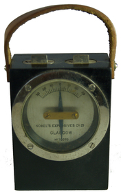
Equipment - Scientific Instrument, Nobel Explosives Co. Ltd, Nobel's Explosives Co Galvanometer, Between 1877 and 1926
Nobel Industries Limited was founded in 1870 by Swedish chemist and industrialist Alfred Nobel for the production of the new explosive dynamite in the United Kingdom. Ardeer, on the coast at Ayrshire, was chosen for the company's first factory. Between 1877 amd 1926 it was known as Nobel’s Explosives Company Limited. The business later diversified into the production of blasting gelatine, gelignite, ballistite, guncotton, and cordite. At its peak, the factory employed nearly 13,000 men and women. In 1926, the firm merged with Brunner, Mond & Company, the United Alkali Company, and the British Dyestuffs Corporation, creating a new group, Imperial Chemical Industries, then one of Britain's largest firms. Nobel Industries continued as the ICI Nobel division of the company. Small black timber box with small screw holding back on, and leather handle on top. A pivoted needle remains vertical as box angle changes. Graded scale behing top end of needle. Two adjusting points at top.No 10070nobel, ballarat school of mines, scientific instruments, galvanometer -
 Bright & District Historical Society operating the Bright Museum
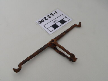
Scales, Weighing
Metal, suspension gold scales, very rusted, gold pans broken. 00223.1 : Arm and handle 00223.2 : Intact dish - brass with four suspension holes. Slight damage on side. 00223.3 : Two parts to the dish - badly damaged.weighing scales, goldfields, chinese, gold, buckland valley -
 Flagstaff Hill Maritime Museum and Village
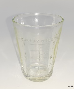
Container - Medicine Glass, ca. 1887 to early 20th century
This small medicine glass has ho manufacturer's or owner's marks. It has no side seams, the base is slightly concave, the embossed inscriptions are inside the glass, the clear glass has slight imperfections and ripples, and the glass is slightly opaque below the lip; these features point to the glass being blown into a mould, partially set, and spun between that mould and an internal mould that had the embossing on it, called a turn-mould process. The lip was then ground to be smooth. The process was patented in 1887 with the title of "Mold for blowing turned bottles".This medicine glass is significant as an example of medical equipment that has a design still used today. It is significant also for having the embossing inside the glass, which was likely produced by the turn-mould method of bottle (and container) making.Medicine glass or dose cup; clear glass with small imperfections and ripples in the glass, no side seams and a slightly concave base. All embossed marks are inside the glass. The imperial measurements are in graduated scales for tablespoons, teaspoons, and ounces and drachmas. "OUNCES DRACHMS" "TABLE TEA"flagstaff hill, warrnambool, shipwrecked coast, flagstaff hill maritime museum, maritime museum, shipwreck coast, flagstaff hill maritime village, great ocean road, medicine glass, measuring glass, dose cup, medicine dispensing, medicine measurement, sambell pharmacy warrnambool, sambell chemist and dentist, internal embossing, glass embossed inside, 20th century chemist, blown glass, two-piece mould, turn-moulded glass, turned bottles -
 Federation University Historical Collection
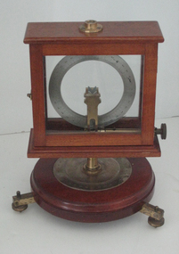
Scientific Instument, Dip Circle Apparatus
Dip circle apparatus contained in a glass-sided vertical wood cabinet, which can be rotated around a vertical axis through 360 degrees. Fully graduated circular scales and levelling screws in the base. Instructions for use available. scientific instrument, dip circle apparatus -
 Bendigo Historical Society Inc.
Map - CAMPBELL COLLECTION: BENDIGO AND DISTRICT MAPS, 11-2-37
Map. Parish of Shelbourne, County of Bendigo. Scale 40 chains to 1 inch. Drawn and reproduced at the Department of Lands and Survey, Melbourne, Victoria. Price 2/-.11-2-37. By Authority H.J. Green, Government Printer, Melbourne.H.J. Green, Government Printermap, bendigo, agricultural lands -
Clunes Museum
Poster, J Curwen & Sons, The Modulator, c.1800
Teaching aid used since the 1800's for learning to sing tonically Printed hanging poster with fabric back, dark green background with cream coloured printed music scales on parchment mounted on wooden rails top and bottom. Bottom rail has acorn ends as is finished in dark stain with varnishNilmusic, teaching aid, curwen & sons, the modulator -
Clunes Museum
Equipment - DRUG SCALES, W A WEBB LTD LONDON
USED IN THE CLUNES HOSPITAL.1 WOODEN BOX BASE WITH ONE DRAWER. .2 METAL MEASURING STAND SCALES. .3 METAL HANGER WHICH MAY HOLD SMALL TRAYS. .4 CURVED BOWL / MEASURING CONTAINERS (2 GLASS, 1 METAL)CLASS B TO WEIGH 2 OZSlocal history, medical & pharmacy, medical pharmacy -
Beechworth Honey Archive
Map- Albury/Wodonga
(5x) Map centred on Albury and Wodonga. Shows Albury and Wodonga, Murray River, Hume Highway, Murray Valley Highway and Riverina Highway. Scale 1:50,000. Paper is white on back and yellow on front. Ca 1974-1975 Labelled 'Albury series R 652'map, albury, wodonga, paper, beechworth honey -
University of Melbourne, Burnley Campus Archives
Plan, Gibson North Island Bed, 2017
(1) Hand-drawn plan of the Gibson North Island Bed with plants, numbers of them, flowering period and season. Scale 1:50. (2) Gibson plant selection and design principals (sic). Colour photographs of some of the plants.gibson north, flower beds, planting -
 Bendigo Military Museum
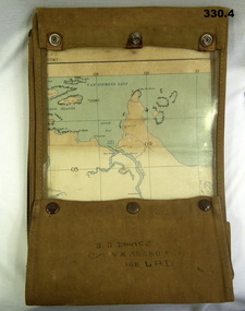
Accessory - MAP CASE & MAPS, C.1939 -45
John James Davies No VX35280 enlisted in the 2nd AIF on 1.8.40 age 31 years. At discharge on 30.11.45 he held the rank of WO 2nd class in 2/108th Aust Light Anti Aircraft detachment..1) Map case, canvas khaki. .2) Map of Darwin, NT. Scale 4 miles to 1 inch. .3) Map, folded, New Guinea made by Hec Robinson Sydney .4) Map Pine Creek N.T.zippered section marked "J. J. Davies VX35280 108 LAD”maps, canvas case, military -
 Flagstaff Hill Maritime Museum and Village
Instrument - Hydrometer, 1878 to 1930s
This Sikes brass hydrometer was manufactured by the optical and scientific instrument makers Kasner & Moss of 17 Collins Street West, Melbourne, in the latter part of the nineteenth century. The firm adverted hydrometers, as well as optical instruments, as early as August 13th, 1864, in The Age, Melbourne. This hydrometer set was donated to Flagstaff Hill in 1979 by local wine and spirits merchants Lynch Bros of Fairy Street, Warrnambool. Giffen Russell had established the business in 1878, and Harry Lynch took it over in the 1930s, and after he passed away in 1953 Kevin Matthew Lynch became proprietor of K M Lynch Food and Liquor. The business closed in the 2010s. The hydrometer may date back to the establishment of the business in 1878, as Kasner & Moss were selling hydrometers in Melbourne from 1864. Hydrometers were used to measure the density, or relative density, of liquids from the late 1600s. In 1816 Bartholomew Sikes won the competition for the most useful accurate hydrometer. Hydrometers were commonly used by distillers, vintners, and brewers to establish accurate measures of alcohol concentration in their beverages. Following this manufacturing process, government inspectors and excise officers used them to check that the labelled indications of alcohol-proof were correct and that the right amounts of duty were being paid. This hydrometer and its fitted and hinged wooden container show signs of heavy and protracted use in a working environment. Although the instrument has some parts missing and has been recently repaired, the original quality of the inlaid box and the fine engraving on the instrument and the attachable weights, are indications of the hydrometer’s very real value when new. This Sikes hydrometer, bearing the maker's mark of “Kasner & Moss Melbourne” and the registered number “20373”, was presented to the purchasing public as a precision-made instrument designed for professional use. The Sikes hydrometer is of local significance because of its implied association with the alcohol trade in the southwest region of Victoria. It was donated by a family member of Lynch Bros, a local licensed outlet for wines and spirits in the period before the general relaxation of liquor licensing laws in the State of Victoria. It may have belonged to Griffin Russell who established the liquor store in 1878.Hydrometer; original Sikes brass hydrometer in a polished wooden case with an inlaid plaque on the lid. The brass float is a sphere with a thin flat upper stem and a short, lower stem with a bulb-shaped end. The upper stem is engraved scale on both sides with the numbers 1 to 10, and five divisions between each number. There are ten fixed pegs in the base to secure the thick brass horseshoe-shaped, numbered, various-sized weights (20, 30, 40, 80, 90); the free pegs would have originally stored another five weights (10, 50, 60, 70, and 100). The empty compartment in the box suggests another part in the initial set, probably a thermometer. The fitted, fabric-lined box has two brass closures and two brass hinges. The scientific instrument shows signs of heavy use and repairs. The Serial Number on the float matches the Serial Numbers on the weights. The plaque on the lid, the float and the weights have inscriptions. Made by Kasner & Moss, Melbourne. Plaque: “SIKES HYDROMETER / KASNER & MOSS / MELBOURNE” On float's lower stem: “SIKES 20373” On one thin edge of the float's scale, engraved in script “Kasner & Moss” and stamped “MELBOURNE”, and symbol“P” rotated 90 degrees. On the opposite thin edge of the float: “N20.373”, “SIKES”, “I P % II O” (in ornate capitals). Each weight has s unique number, and the same serial number “20373”.flagstaff hill, flagstaff hill maritime museum and village, warrnambool, maritime museum, maritime village, great ocean road, shipwreck coast, sikes hydrometer, scientific instrument, pressure measurement, measuring instrument, ullage tool, customs, excise duty, tax, alcohol content, proof, calibrate, standard weights and measures, tariff, kasner & moss, scientific instrument makers, specific gravity, liquid density, alcohol testing, technology, alcohol measurement, proof spirit, wine and spirits merchants, local business, brass measuring instrument, k m lynch, giffen russell, harry lynch -
 The Beechworth Burke Museum
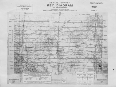
Photograph - Aerial Survey, 5/9/1947
This image is an Aerial Survey, Key Diagram of Beechworth and surrounding area. Issued by Department of Lands and Survey, Victoria in 1947. Photographed at an average height of 12300 feet above sea level, areas depicted are; Beechworth, Stanley, Bruarong, Baranduda, Muagegonga, Myrtleford, Everton, Wooragee North Tarrawinge, Dederang, Kergunyah North, Kergunyah, Yackandandah, El-Dorado, Barambogie, Murmungee, Barwidgee, Oxley, CarraragarmungeeBlack and white rectangular photograph. Image is printed on matt photographic paper and has a white un-printed border. Obverse: AERIAL SURVEY, KEY DIAGRAM OF PHOTOGRAPHS, APPROXIMATE SCALE OF MILES / DEPARTMENT OF LANDS AND SURVEY VICTORIA 5.9.1947. BEECHWORTH 792 ZONE 7. Reverse: BMM7010.1 (written in pencil) aerial survey, beechworth, burke museum, department of lands and survey, victoria, 1947 -
 Bendigo Historical Society Inc.
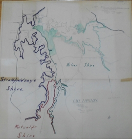
Map - STATE RIVERS AND WATER SUPPLY COMMISSION : LAKE EPPALOCK
State Rivers and Water Supply Commission of Victoria. Coliban System. Lake Eppalock. Map of Lake Eppalock foreshore area. Colour is used to delineate the areas of the Lake included in the three councils - McIvor Shire, Metcalf Shire and Strathfieldsaye Shire. Scale is 1 inch = 40 chains. Various notations in pencil have been added, with 'Coliban Office Plan' written and circled in the top right corner. A coloured (green) area is scaled as 'fore shore area in the charge of Derrinal Recreational Area Management Committee'. Individual leasing details have been added. state infrastructure, water supply, coliban system, state rivers and water supply commission of victoria. coliban system. lake eppalock. -
 Ballan Shire Historical Society
Map - Map. Shire of Ballan, Shire of Ballan
This is a fairly comprehensive map of the former Shire of Ballan which is now amalgamated into the Shire of Moorabool.A black and white map of the Shire of Ballan showing major roads, rivers, towns, settlements, State parks and forests and land subdivisions. It appears to be a copy of the original as no dates or maker or printer appear on the map. There is a scale of 2 miles to 1 inch.gordon, ballan, bungal, kerrit bareet, borhoneyghurk, bungeeltap, ballark, yaloak, gorong, beremboke, wallace, ingliston, hunterston, millbrook, bradshaw, myrniong, blackwood, moorarbool, greendale, bayup, trentham, bullarto, korweinguboora, glenlyon, bolwarra -
 Orbost & District Historical Society
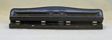
hole punch
This hole punch (also known as a hole puncher) is a common office tool that is used to create holes in sheets of paper, often for the purpose of collecting the sheets in a binder or folder. A 4 hole paper punch made of black painted metal. It has an adjustable centimetre scale for setting hole positions. At its base it has a removable plastic tray for collecting "holes". The blades are small cylinders that will punch small holes, stationery hole-punch -
 Federation University Historical Collection
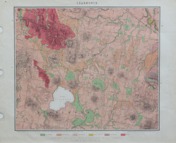
Map, Geological Map of Learmonth, 1882, 10/1882
Two copies: (printed noted attached) 3.) Rectangular geological map edged in masking tape. Six colours define geology and are predominantly pink. Scale 40 chains to one inch .4) Notes referring to the Geological Map of Learmonth learmonth, lake learmonth, glendaruel, burrumbeet, mt blowhard, morton's hill, mt bolan, addington, mt cavern, coghill's hill, mt hollowback, mt pisgah, weatherboard hill, webster's hill, foster's hill, mt bolen, one mile hill, vaughan's hill, tourello stattion, ballarat to maryborough railway, saddleback hill, ceres, brown's hill, ross's hill, norman taylor, robert burrows, richard shephard, james finnie -
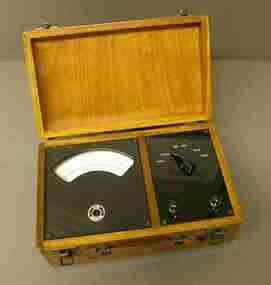 Federation University Historical Collection
Scientific Instument, Micro & Milli Ammeter D.C
Used in Physics and Electrical Engineering laboratory experiments.D.C. micro and milliammeter, 6 ranges: 100 microAmp; 500 microAmp; 1 milliAmp, 5 milliAmp, 10 milliAmp, 50 milliAmp. Semi-circular scale. In varnished wood case with hinged lid. Leather strap carry handle. Series No 5276 Type PC6scientific instrument, ammeter, electrical instrument, physics, electrical engineering, laboratory -
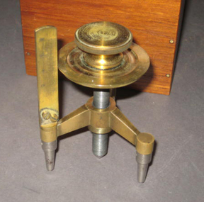 Federation University Historical Collection
Scientific Instrument, Spherometer
A spherometer is an instrument for the precise measurement of the radius of curvature of a sphere or a curved surface. Originally, these instruments were primarily used by opticians to measure the curvature of the surface of a lens. A fixed-frame tripod with adjustable central contact screw, equipped with micrometer scale. Brass construction with steel contact points. Designed for measuring curvature of lenses. Stored in a polished timber box. Made specially for Silberberg and Co. Ltd. Melbournescientific instrument, spherometer, h.b. silberberg & co ltd -
Bendigo Historical Society Inc.
Map - CAMPBELL COLLECTION: BENDIGO AND DISTRICT MAPS, 16-4-29
Map. Kennington, Parishes of Sandhurst, Mandurang and Strathfieldsaye. Scale 20 chains to 1 inch. Total area 2918 acres. Prepared in W.P.B. from A. and C.L. Plans by W.J.Galbraith, 16-4-29. (number 394 in map cupboard 1)W.J.Galbraithmap, bendigo, allotments -
Bendigo Historical Society Inc.
Map - CAMPBELL COLLECTION: BENDIGO & DISTRICT MAPS, 22-3 29
Map. Marong, Parishes of Marong, Lockwood and Mandurang. Scale 20 chains to an inch. Total area 5106 acres. Crusoe Reservoir on right. Compiled in W.P.B. from Field Survey and Parish Plans (number 373 in map cupboard 1)G.W.Lmap, bendigo, allotments -
Bendigo Historical Society Inc.
Map - CAMPBELL COLLECTION: BENDIGO AND DISTRICT MAPS
Map. Marong, Parishes of Marong, Lockwood and Mandurang. Scale 20 chains to an inch. Total 5106 acres. Compiled in W.P.B. from Field Survey and Parish Plans. Crusoe Reservoir to the right of map. (number 362 in map cupboard 1)map, bendigo, parish plan -
Bendigo Historical Society Inc.
Map - CAMPBELL COLLECTION: BENDIGO AND DISTRICT MAPS, 6-4-28
Map. Sedgwick, Parishes of Strathfieldsaye, Lyell, and Sedgwick. Scale 20 chains to 1 inch. Total area 5372 acres. Prepared in W.P.B. from C.L.and A. Plans by W.J.Galbraith 6-4-28. (number 400 in map cupboard 1)W.J.Galbraith.map, bendigo, agricultural lands -
Port Melbourne Historical & Preservation Society
Book, Universal Business Directories (Aust) Pty Ltd, Universal DeLuxe Streets Directory, 1959
1959 Streets Directory for Melbourne City and Suburbs including large scale maps, hospitals, schools, police stations, town halls, telephone booths, tram stops, railways. Fifth edition. Red and Buff cardboard cover, red binding.transport - roads, street directory -
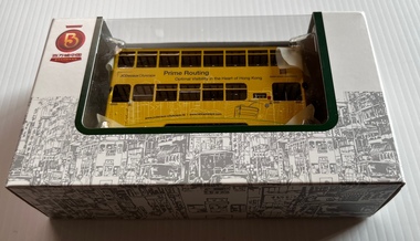 Ballarat Tramway Museum
Model - Model Hong Kong double decker 45, Bachmann Models, c1990
Model of a Hong Kong double deck tram, No. 45 made by Bachmann models, China. Painted in an overall advertising scheme for Prime Routing for JCDecaux advertising.Demonstrates of a model of Hong Kong double decker tram.Model of Hong Kong double decker tram in cardboard box, clear plastic packaging, instruction sheets made fitted with a motorised bogie, trolley pole. Model shows seats and stairways on upper deck. HO Scale. Model is operable.models, tramcars, hong kong, bachmann models -
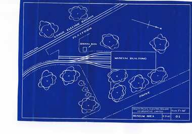 Ballarat Tramway Museum
Plan, South Pacific Electric Railway, SPER Museum Area, 9/09/1960 12:00:00 AM
A blueprint of drawing 01 of the South Pacific Electric Railway showing 1960 proposal for the layout of the SPER Museum area, scale 1" = 32'. Drawing No. 01, Shows NSWGR railway. Scan added and entry updated 19-8-13trams, tramways, sper, loftus, museum plan -
 Kew Historical Society Inc
Map, Osboldstone & Co Pty Ltd, Railway and Tramway Map of Melbourne and Suburbs With Tram Timetables, 1917
The Railway and Tramway Map of Melbourne and Suburbs With Tram Timetables lists existing Cable Tram Services before the entire network was electrified. By 1917 the tramways system was divided into regions including: the Melbourne Cable Tram Service; Prahran - Malvern Electric Trams; Hawthorn Electric Trams; Melbourne, Brunswick and Coburg Electric Trams; and Brighton Beach Electric Trams. The old Outer Circle railway line is marked as ending in Deepdene, with the remainder of the line to Fairfield marked as 'Unused'. The Kew tram along High Street in 1917 ended at the Harp Junction. The Kew Spur Line is also marked on the map.The Railway and Tramway Map of Melbourne and Suburbs With Tram Timetables is historically significant as it captures at a point in time, 1917, the development of public transport infrastructure in Melbourne. As such it illustrrates the theme: Connecting Victorians by transport and communications.Printed card-covered pocket sized map that folds out with three horizontal and vertical folds. Colour map, with scale, of the rail and tram networks on one side and sixteen sections of black and white printed text and timetable information on the reverse.railway maps -- melbourne (vic.), tramways maps -- melbourne (vic.), public transport -- melbourne (vic.) -- 1910-1920, cartography -
Glenelg Shire Council Cultural Collection
Plan - Plan / Line Drawings - Port of Portland Authority Single Screw Fishing Vessel, Victoria, c. 1980
PORT OF PORTLAND AUTHORITYLine drawings, Bob McLaren Pty Ltd, Boatbuilders, Ballina NSW. Single screw fishing vessel 72' 7" x 21'0". Scale 1/2 inch = 1 foot Drawing no. 72-7/P/1 as liftedFront: '45' - black texta, top right corner -
Glenelg Shire Council Cultural Collection
Plan - Plans / Line Drawings - Port of Portland Authority, Victoria, n.d
PORT OF PORTLAND AUTHORITYFront: '47' - black texta, top right corner -
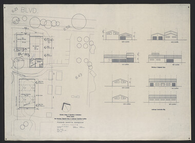 University of Melbourne, Burnley Campus Archives
Plan, Fooks Martin Sandow Pty. Ltd, Victorian College of Agriculture & Horticulture Burnley Campus New Workshop, Equipment Store, & Landscape Construction Facilities, 1996
Plans by Fooks Martin Sandow, August 1996. Scale 1:200. (1) New Mechanics Workshop, New Equipment Store, etc. and Landscape Construction, with Elevations. (2) Layout of Equipment Store - where each piece of equipment to be placed.vcah, fooks martin sandow, equipment store, landscape construction -
Linton and District Historical Society Inc
Plan, Sketch and plan for Pioneer Memorial and Garden, Linton
A memorial cairn honouring the memory of the pioneers of Linton and district was erected in 1939 and unveiled on 24 December of that year. In 1941 the Old Lintonians' Association decided to make improvements to the site of the cairn. In February 1941, and a plan was drawn up at the office of L. H. Vernon , Civil Engineer & Architect, Ballarat. Improvements were finished by May 1941, however it is understood that the design was never properly implemented.Original plan and "perspective sketch" for the Linton pioneer memorial and garden, drawn up in 1941. Coloured pencil and ink drawings on a sheet of parchment. Scale: 1/4 inch : 1 foot. Dated 7.2.41. The plan has been laminated.linton pioneer memorial, gardens, plans, technical drawings, l.h. vernon civil engineer & architect