Showing 3866 items
matching surveying-terrestrial
-
 University of Melbourne, Burnley Campus Archives
Plan, Yarra 500/045.043 Municipalities of Prahran 211 and Richmond 207, 1979
Melbourne and Metropolitan Board of Works Series 1:500. Map prepared by the Survey Division, MMBW January 1979. Scale 1:500. Area surrounding Heyington Station and St. Kevin's Junior Schoolmelbourne and metropolitan board of works, prahran, richmond -
University of Melbourne, Burnley Campus Archives
Card, The University of Melbourne, Survey of the Australian Hydroponics Industry, 1996
hydroponics, crops -
 Bendigo Historical Society Inc.
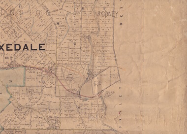
Map - Parish of Strathfieldsaye
Map owned by Henry Thomas (Jack) Qualtrough who worked for the Victorian Forestry Commission. Shire of Strathfieldsaye County of Bendigo canvas backed map. L5169. Includes Axedale, Kimbolton, Eppalock and Sedgewick. Photographed/Lithographed for the Department of Lands and Survey Melbourne by T E McGauran 24.3.07. Price 1/-.map, axedale, kimbolton, sedgewick, eppalock -
 Bendigo Historical Society Inc.
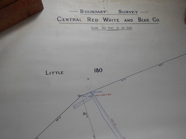
Administrative record - Central Red White and Blue Mine Map
Draftsman's drawing Boundary Survey of Central Red White and Blue Co Map. Handwritten signature of Garnet G Buich, Licensed Mining Surveyor Forms part of the Margaret Roberts Collection of mining records.bendigo, margaret roberts, gold, map, mine, central red white and blue -
 Bendigo Military Museum
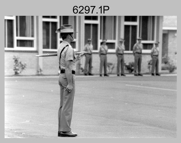
Photograph - Army Survey Regiment – RSM Handover at CO's Parade, Fortuna, Bendigo, 1995
These 15 photographs were taken in 1995 during a CO’s Parade at the Army Survey Regiment, Fortuna, Bendigo in 1995. On this occasion outgoing RSM WO1 Phil Meagher handed over to incoming RSM WO1 Ken Johnston OAM MM. WO1 Phillip Nicholas Meagher served in the Australian Regular Army (ARA) from Jan 1971 to Jun 1997. He was RSM of the Army Survey Regiment from 1992 to 1995. He was succeeded by WO1 Ken Johnston OAM MM from the Royal Australian Infantry Corps, who was RSM for the remainder of 1995. WO1 Johnston served in the Citizens’ Military Force and the ARA from Feb 1966 to Mar 2002. A tribute in the Army Newspaper on the 14 May 2014 and discoverable on the Trove website, stated he passed away on 12 May 2014. In this tribute it stated he was a Vietnam War Military Medal recipient, known as a “Digger’s Digger” and for his direct no-nonsense approach. As RSM of the Army Survey Regiment, WO1 Johnston was instrumental in shaping and sharpening the military skills and behaviours of personnel who chose to continue in their reallocation to other corps in the ARA or the 1st Topographic Support Squadron in Enoggera, QLD. His tenure is covered in more detail on page 164 of Valerie Lovejoy’s book 'Mapmakers of Fortuna – A history of the Army Survey Regiment’ ISBN: 0-646-42120-4. On this occasion CO LTCOL Duncan Burns presented MAJ Mick Banham the Defence Force Service Medal for 15 years of efficient remunerated service in the Australian Army. This is a set of 15 photographs taken of a RSM Handover at a CO’s Parade at the Army Survey Regiment, Fortuna, Bendigo, 1995. The photographs were printed on photographic paper and are part of the Army Survey Regiment’s Collection. The photographs were scanned at 300 dpi. .1) - Photo, black & white, 1995. Outgoing RSM WO1 Phil Meagher. .2) - Photo, black & white, 1995. L to R: MAJ Mick Banham, outgoing RSM WO1 Phil Meagher. .3) - Photo, black & white, 1995. L to R: CO LTCOL Duncan Burns, MAJ Mick Banham. .4) - Photo, black & white, 1995. L to R: ADJT CAPT Brenton McDonald, RP SGT Peter Coles, CO LTCOL Duncan Burns, MAJ Mick Banham receiving Defence Force Service Medal. .5) - Photo, black & white, 1995. L to R: ADJT CAPT Brenton McDonald, CO LTCOL Duncan Burns, MAJ Mick Banham (background), outgoing RSM WO1 Phil Meagher, incoming RSM WO1 Ken Johnston OAM MM, CAPT Bin Fashar Sutiman (Indonesian Army). .6) - Photo, black & white, 1995. L to R: SGT Perry Langberg, MAJ Dave Stephenson, SPR Trevor King, SPR Craig Smith, CAPT Colin Davidson, LCPL Mark Fedden, SPR Donna Grayland. .7) - Photo, black & white, 1995. L to R: unidentified (x3), RSM WO1 Phil Meagher, SGT Darren Wilkinson, SSGT Steve Drummond, unidentified, SPR Donna Grayland, SPR Allison Ottaway, unidentified, back of ADJT CAPT Brenton McDonald, unidentified (x4), CPL Darren Maher, SGT Laurie Justin. .8) - Photo, black & white, 1995. Outgoing RSM WO1 Phil Meagher, remainder unidentified. .9) - Photo, black & white, 1995. L to R: WO2 Peter Imeson, CPL Darren Maher, unidentified, SSGT Steve Winner. .10) - Photo, black & white, 1995. L to R: MAJ Mick Banham, ADJT CAPT Brenton McDonald, CAPT Doug Arman, WO1 Phil Meagher, CAPT Bin Fashar Sutiman (Indonesian Army), WO1 Ken Johnston OAM MM, CAPT Bill Griggs, unidentified. .11) - Photo, black & white, 1995. L to R: WO1 Ken Johnston OAM MM, ADJT CAPT Brenton McDonald. .12) - Photo, black & white, 1995. Outgoing RSM WO1 Phil Meagher. .13) - Photo, black & white, 1995. L to R: Outgoing WO1 Phil Meagher, incoming RSM WO1 Ken Johnston OAM MM. .14) - Photo, black & white, 1995. L to R: Incoming RSM WO1 Ken Johnston OAM MM, outgoing WO1 Phil Meagher. .15) - Photo, black & white, 1995. L to R: MAJ Mick Banham, RP SGT Peter Coles, outgoing RSM WO1 Phil Meagher..1P to.15P – There are no annotations.royal australian survey corps, rasvy, army survey regiment, army svy regt, fortuna, asr -
 Bendigo Historical Society Inc.
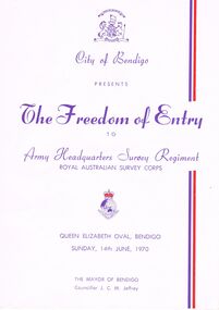
Document - THE FREEDOM OF ENTRY TO ARMY HEADQUARTERS SURVEY REGIMENT, QUEEN ELIZABETH OVAL, 14 June, 1970
The Freedom of Entry to Army Headquarters Survey Regiment Royal Australian Survey Corps, Queen Elizabeth Oval, Bendigo, Sunday, 14th June, 1970.The Mayor of Bendigo Councillor J C M Jeffrey. Presented by City of Bendigo. Photographs of the Mayor of Bendigo Councillor J C M Jeffrey, Colonel Commandant of the Regiment Brigadier D Macdonald and Commanding Officer Lt Col L B Sprenger, MBE. The City of Bendigo On the 14th day of June 1970 we extend to the Commanding Officer, Officers and Men of the A. H. Q. Survey Regiments Greetings Whereas the Bendigo City Council at a meeting held on the 20th day of April 1970 resolved unanimously that in appreciation of your loyal service to Our Sovereign Our Country and Our City and in recognition of the long and close association existing between the city and the Regiment in which so many of our citizens have been proud to serve, we hereby confer upon such Regiment by this Deed and in perpetuity the privilege honour and distinction of the Freedom of Entry into the City of Bendigo on Ceremonial Occasions in full panoply with Swords drown Bayonets fixed Drums beating Bands playing and Colours Flying. In Witness whereof the Common Seal of the Council was hereto affixed on the 14th day on June 1970 in the presence of J C M Jeffrey Mayor A J Watts Town Clerk. Order Of Ceremony Sunday, 14th June commencing at 1.45pm Bendigo Bands will play selections until 2.10pm, when Bands will move off the arena. The parade of Army Headquarters Survey Regiment Marches into the Queen Elizabeth Oval, Led by the Band of the Royal Australian Armoured Corps . . . Bendigo city council 1969-70 councillors listed . . . Officers Serving with Army Headquaters Survey Regiment on 14th June, 1970, listing . . . A Short History of the Regiment's Association with the City of Bendigo; 1942-1970. On 27th March, 1942, 'Fortuna' was occupied by LHQ Cartographic Company, Australian Survey Corps. . . . Commanding Officers of AHQ Survey Regiment. . . 11 pages.event, official, army survey regiment, the freedom of entry to army headquarters survey regiment royal australian survey corps, queen elizabeth oval, bendigo, sunday, 14th june, 1970.the mayor of bendigo councillor j c m jeffrey. presented by city of bendigo. photographs of the mayor of bendigo councillor j c m jeffrey, colonel commandant of the regiment brigadier d macdonald and commanding officer lt col l b sprenger, mbe. the city of bendigo on the 14th day of june 1970 commanding officer, officers and men of the a. h. q. survey regiments greetings bendigo city council at a meeting 1970 resolved unanimously that in appreciation of your loyal service to our sovereign our country and our city the freedom of entry into the city of bendigo on ceremonial occasions in full panoply with swords drown bayonets fixed drums beating bands playing and colours flying. order of ceremony sunday, 14th june commencing at bendigo bands bands. the parade of army headquarters survey regiment marches into the queen elizabeth oval, royal australian armoured corps . . . bendigo city council 1969-70 councillors listed . . . officers serving with army headquaters survey regiment on 14th june, 1970, listing . . . a short history of the regiment's association with the city of bendigo; 1942-1970. on 27th march, 1942, 'fortuna' was occupied by lhq cartographic company, australian survey corps. . . . commanding officers of ahq survey regiment -
 Bendigo Military Museum
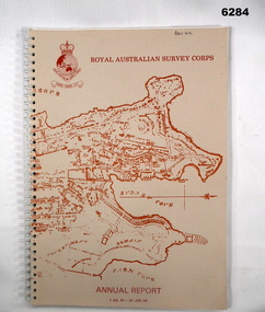
Booklet - Royal Australian Survey Corps - Annual Report 1 Jul 87 - 30 Jun 88, Director of Military Survey -Army, 01.09.1988
Royal Australian Survey Corps Annual Report detailing Surveying and mapping activities 1 July 87 - 30 Jun 88. The first part of the report details the highlights during the period followed by Annexes A to J detailing Australian Map and Chart production. Annex A: 45 pages, Annex B: 1 page Aust Doppler Satelite Stations, Annex C: 1 page, Aust airborne Profile Recording, Annex D: 1 page Aust Aerial photography, Annex E: 1 page Aust Analytical Aerotriangulation, Annex F: 1 page Inertial Positioning System Network Traverses Fils Svy, Annex G: 1 page Global Positioning System Station/networks TI4100 Svy, Annex H: 1 page, Defence Cooperation Programme, Annex I 3 Pages RASvy Officer Manning, Annex J: 1 page RASvy ARES Manning Levels.Buff coloured light cardboard covers. Old map of Sydney Cove area printed in red/brown on front cover and Survey Corps Badge in red top left corner. "Map of the town of Sydney 1836" printed on back cover. A4 sized paper pages, 17 numbered pages plus, Annex A: 45 x pages, Annex B: 1 x page Aust Doppler Satellite Stations, Annex C: 1 x page, Aust Airborne Profile Recording, Annex D: 1 x page Aust Aerial photography, Annex E: 1 x page Aust Analytical Aerotriangulation, Annex F: 1 x page Inertial Positioning System Network Traverses Fils Svy, Annex G: 1 x page Global Positioning System Station/Networks TI4100 Svy, Annex H: 1 x page, Defence Cooperation Programme, Annex I 3 x pages RASvy Officer Manning, Annex J: 1 x page RASvy ARES Manning Levels.royal australian survey corps, rasvy, fortuna, army survey regiment, army svy regt, asr -
 Bendigo Military Museum
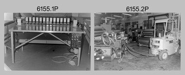
Photograph - Equipment and Personnel, Lithographic Squadron - Army Survey Regiment, Bendigo, c1975
This is a set of 21 photographs of Lithographic Squadron equipment and personnel as well equipment operated by Cartographic Squadron, Army Survey Regiment, Fortuna, Bendigo circa 1975. The photos were mainly taken in the Printing, Camera, proofing and external buildings. Cartographic Squadron’s CPL Arty Lane operated the Fotosetter type setting machine, as shown in photo .21P for many years in a room on the top floor of Fortuna Villa. There is more information on the Ultra-MAN-III Printing Presses, the KLIMSCH Commodore camera, Gavin Neilson and the Fotosetter type setting machine on pages 70-71, and the Newkoni Komori printing press on page 120 of Valerie Lovejoy’s book 'Mapmakers of Fortuna – A history of the Army Survey Regiment’ ISBN: 0-646-42120-4.This is a set of 21 photograph of Lithographic Squadron equipment and personnel, Army Survey Regiment at Fortuna, Bendigo, 1989. Black and white photographs .1P to .13P are on 35mm negative film and scanned at 96 dpi. Black and white photos .14P to .21P are on photographic paper and were scanned at 300 dpi. .1) - Photo, black & white, c1975, tri-linear film punch. .2) to .5) - Photo, black & white, c1975, Newkoni Komori printing press components. .6) - Photo, black & white, c1975, Newkoni Komori printing press components, Alex Cook. .7) - Photo, black & white, c1975, Newkoni Komori printing press components. .8) to .12) - Photo, black & white, c1975, northern exterior of print buildings. .13) - Photo, black & white, c1975, L to R: unidentified (x2), Jim Mulqueen, Ian ‘Lofty’ Turner. .14) - Photo, black & white, c1975, Log Electonics film processor. .15) - Photo, black & white, c1975, contact frame. .16) - Photo, black & white, c1975, film tri-punch stud registration table. .17) - Photo, black & white, c1975, Ultra-MAN-III Printing Presses. .18) to .19) - Photo, black & white, c1975, KLIMSCH Commodore camera, Gavin Neilson. .20) - Photo, black & white, c1975, map proof whirler. .21) - Photo, black & white, c1975, Fotosetter type setting machine.No personnel are identified. .14P, .16P to .19P and .20P to .21P are annotated with 5-digit numbers on top right corner of photo.royal australian survey corps, rasvy, army survey regiment, army svy regt, fortuna, asr, litho, carto -
 Bendigo Military Museum
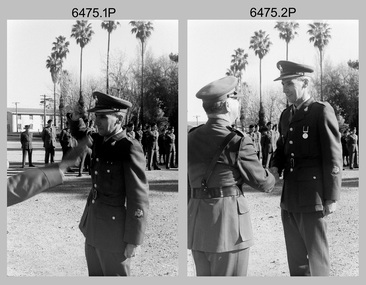
Photograph - Army Survey Regiment – CO’s Parade and Defence Force Service Medal Presentations, Fortuna Villa, Bendigo, c1977
This set of 18 photographs were taken at a CO’s parade at the Army Survey Regiment, Bendigo in c1977. LTCOL George Ricketts presented the Defence Force Service Medal to personnel in recognition of 15 years of efficient remunerated service, or the Clasp for 5 years of additional service. See item 6071.2P for a group photo of LTCOL George Ricketts with the medal recipients.This is a set of 18 photographs of a CO’s parade and the presentation of the Defence Force Service Medal, at the Army Survey Regiment, Bendigo in c1977. The black & white photographs are on 35mm negative film and are part of the Army Survey Regiment’s Collection. The photographs were scanned at 96 dpi. .1) to 2) - Photo, black & white, c1977. LTCOL George Ricketts presents medal to WO1 Joe Farrington. .3) - Photo, black & white, c1977. LTCOL George Ricketts presents medal to WO1 Ike Lever. .4) - Photo, black & white, c1977. LTCOL George Ricketts presents medal to RSM WO1 Aub Harvey. .5) - Photo, black & white, c1977. LTCOL George Ricketts presents medal to ex-serviceman John Rankine. .6) - Photo, black & white, c1977. LTCOL George Ricketts presents medal to CPL Ian ‘Lofty’ Turner. .7) - Photo, black & white, c1977. LTCOL George Ricketts presents medal to SGT Peter Saunders. .8) - Photo, black & white, c1977. LTCOL George Ricketts presents medal to SGT Ross Hyde. .9) - Photo, black & white, c1977. Unidentified squadron marching past Fortuna Villa. In background 2nd from left – SGT Bob Williams. In foreground L to R: WO1 Jim ‘Triple J’ Jefferies, CPL Neville Stone, CPL Andy Wilson. .10) - Photo, black & white, c1977. Unidentified squadron marching past Fortuna Villa. .11) & .12) - Photo, black & white, c1977. Unidentified squadron marching past Fortuna Villa. In foreground L to R: WO1 Jim ‘Triple J’ Jefferies, CPL Neville Stone, CPL Andy Wilson, CPL Bruce Gordon. .13) - Photo, black & white, c1977. Medal recipient ex-serviceman John Rankine with family after medal presentation. .14) & .15) - Photo, black & white, c1977. Centre: CAPT Terry Edwards with medal recipients L to R: SGT Peter Saunders and SGT Jim Mulqueen. .16) - Photo, black & white, c1977. Medal recipient RSM WO1 Aub Harvey with family after medal presentation. .17) - Photo, black & white, c1977. CO LTCOL Peter Constantine AM after medal presentation. .18) - Photo, black & white, c1977. Medal recipient SGT Jim Mulqueen with family after medal presentation.No personnel are identified.royal australian survey corps, rasvy, army survey regiment, army svy regt, fortuna, asr -
 Federation University Historical Collection
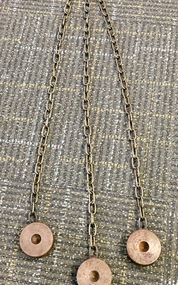
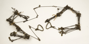
Instrument - Scientific Instruments, Tripod Location Chains
... surveying ...Surveying instrument accessories. Two sets. Used in conjunction with item 4129 - Collapsible leg surveying instrument, tripod. Could also be used with item 4130 - Plane Table which goes with the tripod mentioned.A set of three steel discs, connected in star configuration by three brass chains of equal length. Used to contain tripod ends on hard smooth surfaces.surveying, metal, steel discs, scientific instruments, location chains, plane table -
 Rutherglen Historical Society
Map, 1908
This is a map produced as part of a book entitled.. It is also stamped on the back in blue ink with an oval ring and the words North of England Institute. Newcastle. Mining & Meterolgical Faculty. Purchased on 23rd July 2017 by the Society after research by member Simon Killeen. Mining map of one of the first mines in Rutherglen area ( Chiltern West)Cream paper, black printing, rectangle with a drawingGeographical Survey of Victoria, Memoir, No6. Plate XX Plan of Underground Workings CHILTERN VALLEY CONSOLS MINE, RUTHERGLEN, PARISH OF CHILTERN WESTgold, rutherglen, mining, chiltern, underground mine map, geological survey, reef drives -
 Forests Commission Retired Personnel Association (FCRPA)
Gunter's Chain
... Surveying ...Before metrication was introduced into Australia in the 1970s land was measured in chains and links. Many old parish plans show length measurements in chains and links. Area was shown in acres, roods and perches. Gunter's chain was used for measuring distance in surveying. It was designed and introduced in 1620 by English clergyman and mathematician Edmund Gunter (1581–1626). Gunter developed the measuring chain of 100 links. The chain and the link, became statutory measures in England and subsequently the British Empire. After metrication units of length were measured in meters and area in hectares. The chain was later superseded by steel ribbon tape.The 66 foot long brass Gunter's Chain is divided into 100 links (each 7.92 inches long), and marked off into groups of 10 by shaped tags which simplify intermediate measurement. It was heavy but flexible enough to be dragged through the bush on surveying transects.(Hence the common forestry term "chainman). The chain was a precision part of a surveyor's equipment. It required frequent calibration, yet needed to be sturdy enough to be dragged through rough terrain for years. It has brass hand grips at each end of chain. 1 chain = 100 links = 22 yards = 66 feet = 792 inches. 10 chains = furlong 80 chains = 1 mile 1 acre = 10 square chains = 4 roods (1/4 acre) = 40 perches.forest measurement, surveying, forests commission victoria (fcv) -
 Lorne Historical Society
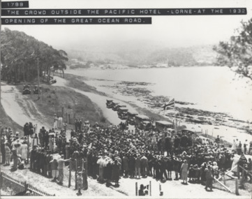
Photograph, Offical Opening Celebrations at Pacific Hotel Lorne 26th November 1932
The Great Ocean Road was officially declared open on 26th November 1932 at a ceremony near Lorne's Grand Pacific Hotel, the site where the first survey peg for the road was hammered into the ground 14 years before. opening ceremony: lorne pacific hotel: 26/11/1932 -
Glenelg Shire Council Cultural Collection
Certificate - Survey certificate, Apr-68
Retrieved from the files of the former MCD Manager at Portland Visitor Information CentreFoolscap size Certificate of Survey for "Lewis", No 165, dated 5th April 1968 entitling "Lewis" to operate within the limits of the Port of Portland until 7th Feb 1969. Embossed with the seal of the Marine Board of Victoria. -
Glenelg Shire Council Cultural Collection
Map - Map - Paper Survey, n.d
Paper survey map, ink and watercolour, framed under glass. Painted black gloss. Shows Fawthrop lagoon and surrounds including Fawthrop's home 'Windsor Cottage', outbuildings and garden, Cairncross and Howard holdings and othersBack: 'Town of Portland' -
Federation University Historical Collection
Map, Town of Buninyong, 1927, 09/1927
The date of this map is September 1927 revised from the original 1910 map. Buninyong was created a district on 09 July 1858, proclaimed a Shire on 16 February 1864, and the Buninyong Borough united on 01 October 1915.Township plan of the Town of Buninyong showing government roads and crown allotments. Earlier detail pencilled on (commercial buildings, etc) appears to be from an 1850 survey. Scale: 4 chains to 1 inch (1:3168)buninyong, map, buninyong botanical gardens, tannery dam, buninyong reservoir, chapel school, rev. hastie -
Glenelg Shire Council Cultural Collection
Photograph - Photograph - Main Breakwater construction, Portland, Dec-96
Port of Portland Authority ArchivesBack: Lady Bay Rain Dec 1996port of portland archives, main breakwater, construction, portland, harbour, harbour development -
Bendigo Historical Society Inc.
Map - PANNOOMILLOO : COUNTY OF BENDIGO, 17-12-13
Map. Pannoomilloo, County of Bendigo, Pannoobamawm, Warragamba, Milloo, Diggorra. Photo-Lithographed at the Department of Lands and Survey, Melbourne by W.J. Butson 17-12-13, Price 1/-. (number 82 in map cupboard 1)W.J. Butson.map, bendigo, pannoomilloo -
 Bendigo Historical Society Inc.
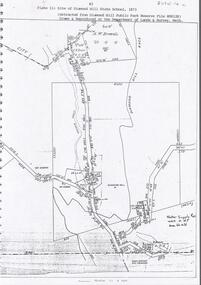
Document - DIAMOND HILL STATE SCHOOL SITE
Map (copy) showing the site of Diamond Hill State School, 1873. On top of page 'extracted from Diamond Hill Public Park Reserve File RS8128, drawn and reproduced at the Department of Lands and Survey, Melbourne'bendigo, education, diamond hill state school -
 Bendigo Historical Society Inc.
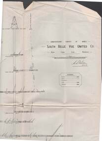
Map - STRUGNELL COLLECTION: UNDERGROUND SURVEY OF MINES, BENDIGO, 29-3-01
Map, Underground Survey of Mines, Bendigo, South Belle Vue United Co.,New Chum Line.Transverse Section. Signed H.S.Whitelaw29.3.01 Drawing appears to show samples of connecting horizontal shafts with their respective mineral contentsH.S.Whitelawmap, bendigo, south belle vue united co.. -
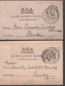 Bendigo Historical Society Inc.
Document - CONNELLY, TATCHELL, DUNLOP COLLECTION: LETTER ACKNOWLEDGEMENT CARDS
2 Buff coloured cards to Connelly , Tatchell & Dunlop acknowledging receipt of letters from Thos. F. Morkham, Secretary for Lands, dated 1898 and 1899. Official stamps on the front -with - Minister of Lands and survey Victoriabusiness, legal, connelly & tatchell -
Bendigo Historical Society Inc.
Map - CAMPBELL COLLECTION: BENDIGO AND DISTRICT MAPS, 1959
Map. Huntly, County of Bendigo, Neilborough, Bagshot, Nerring, Wellsford, Sandhurst. Township of Huntly. By Authority A.C. Brooks, Government Printer Melbourne. Drawn and reproduced at the Department of Lands and Survey, Melbourne, 1958. Price 5/-.A.C. Brooks, Government Printermap, bendigo, allotments -
Port Melbourne Historical & Preservation Society
Book, "City of Port Melbourne Childrens and Family Services - A Review 1989", 1989
"City of Port Melbourne Childrens and Family Services - A Review 1989". A detailed review of family and children's services in Port Melbourne. Including results of surveys sent to households with pre-school children. Yellow front page.local government - city of port melbourne -
Port Melbourne Historical & Preservation Society
Plan - Sandridge, Department of Lands and Survey, "The Township of Sandridge", 5 Nov 1860
Map of Sandridge, lithographed 1860, showing subdivisions on Evans Street, but no other development West of the railway Lihographed at the Department of lands and Survey, Melbourne 5th November 1860. Hand drawn annotations added at unknown date.Hand written "clay ground" 18 chains long, 7.5 chains broad, 26 chains from railwayengineering - roads streets lanes and footpaths, sandridge lagoon, transport - railways, town planning, local government - borough of sandridge -
Port Melbourne Historical & Preservation Society
Letter - Department of Lands and Survey re notification of crown grants for Sandridge municipal chambers and market site, Department of Lands and Survey, 20 Jun 1862
Handwritten letter on blue foolscap laid paper, from Dept of Lands and Survey 20.6.1862 notifying Town Clerk of two crown grants, for municpal chambers and for market site. Paper watermarked A.Cowan & Sons 1855Notations in pencil on back, upper leftlocal government - borough of sandridge, market reserve, port melbourne town hall -
Port Melbourne Historical & Preservation Society
Letter - Department of Lands and Survey re proclaimation for site of Sandridge municipal common, Department of Lands and Survey, 10 Oct 1863
Handwritten letter on blue foolscap laid paper, from Dept of Lands and Survey 10.10.1863, directing attention to proclamation in Government Gazette re site for Sandridge municipal common. Paper, watermarked TH Saunders 1862local government - borough of sandridge, port melbourne town hall -
Bendigo Historical Society Inc.
Document - DVD OF 1856 PETITION AND INDEX, 1856
DVD/CD. Transcription of names from 1856 Petition from persons at Sandhurst occupying Lands under Business Licenses praying that if the intention of Govt is carried into effect, their lands may be surveyed for sale and the improvements valued.bendigo, law, land improvements -
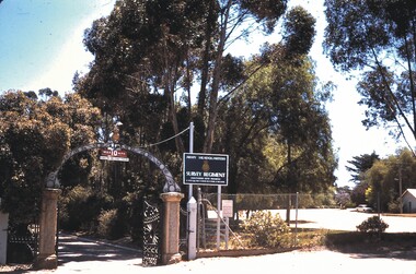 Bendigo Historical Society Inc.
Slide - BENDIGO STREET VIEWS & FORTUNA, Jan 1970
Slide. Bendigo Street Views & Fortuna. Front gate consisting of two brick pillars,wrought-iron arch,with Army Survey Regiment Icon on top,two w/iron gates & Sign to the right of the gates.slide, bendigo, bendigo street views & fortuna., bendigo street views & fortuna. -
 Whitehorse Historical Society Inc.
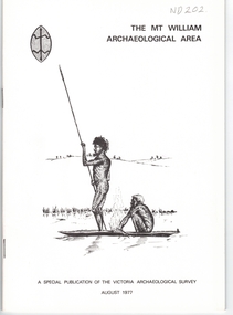
Document, Mt William Archaelogical Area, 1/08/1977 12:00:00 AM
Booklet issued by the Victorian Archaelogical Survey describing an abouiginal axe quarry at Mt William near Lancefield. The history of the site is described as is the archaelogical evidence.Booklet issued by the Victorian Archaelogical Survey describing an abouiginal axe quarry at Mt William near Lancefield. The history of the site is described as is the archaelogical evidence. A section describes the importance of axes in aboriginal culture. Map, illustrations.Booklet issued by the Victorian Archaelogical Survey describing an abouiginal axe quarry at Mt William near Lancefield. The history of the site is described as is the archaelogical evidence. aborigines, stone axes, mount william -
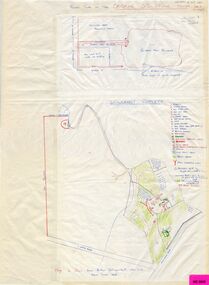 Whitehorse Historical Society Inc.
Map, Schwerkolt property and rough plan of old stone house, 1993
Map drawn by Arthur SchwerkoltMap drawn by Arthur Schwerkolt in 1993 from memory assisted by survey map of 1902. Covering letter from Glyn France [also at ND1367 (G-H-S-C 46) gives extra details.Map drawn by Arthur Schwerkoltschwerkolt cottage, schwerkolt, arthur, whalen, rosalie, france, glyn